The E17 postcode district is a postal district located in the E London - E postcode area with a population of 113,053 residents according to the 2021 England and Wales Census.
The area of the E17 postcode district is 5.34 square miles which is 13.84 square kilometres or 3,420.32 acres.
Currently, the E17 district has about 1480 postcode units spread across 7 geographic postcode sectors.
Given that each sector allows for 400 unique postcode combinations, the district has a capacity of 2,800 postcodes. With 1480 postcodes already in use, this leaves 1320 units available.
The E17 postal code covers the settlement of WALTHAMSTOW.
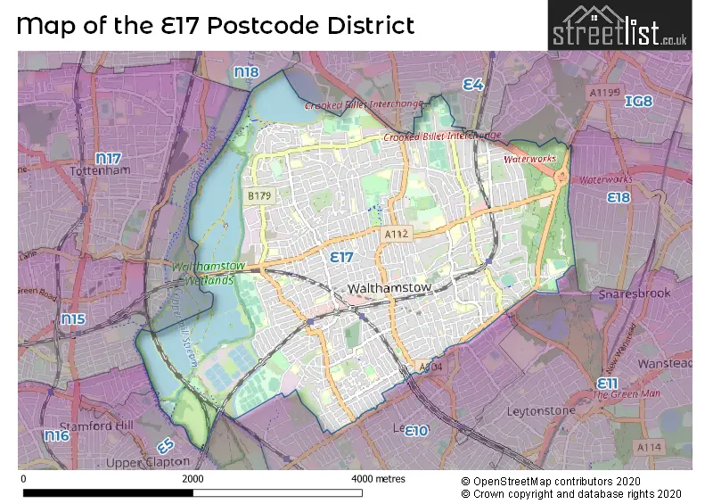
The E17 Postcode shares a border with E10 (LEYTON), E11 (LEYTONSTONE, WANSTEAD), E5 (HACKNEY), IG8 (WOODFORD GREEN), N17 (TOTTENHAM), E4 (CHINGFORD) and N18 (EDMONTON).
The primary settlement in the E17 postcode district is Waltham Forest, located in Greater London. The most significant post town in this district is London, also in Greater London.
For the district E17, we have data on 8 postcode sectors. Here's a breakdown: The sector E17 0 is non-geographic. It's often designated for PO Boxes, large organisations, or special services. The sector E17 3, covers Waltham Forest in Greater London. The sector E17 4, covers Waltham Forest in Greater London. The sector E17 5, covers Waltham Forest in Greater London. The sector E17 6, covers Waltham Forest in Greater London. The sector E17 7, covers Waltham Forest in Greater London. The sector E17 8, covers Waltham Forest in Greater London. The sector E17 9, covers Waltham Forest in Greater London.

Map of the E17 Postcode District
Explore the E17 postcode district by using our free interactive map.
When it comes to local government, postal geography often disregards political borders. However, for a breakdown in the E17 District: the district mostly encompasses the Waltham Forest London Boro area with a total of 1514 postcodes.
Recent House Sales in E17
| Date | Price | Address |
|---|---|---|
| 16/10/2023 | £730,000 | Downsfield Road, London, E17 8BZ |
| 13/10/2023 | £580,000 | Bridge End, London, E17 4ER |
| 13/10/2023 | £560,000 | Mayfield Road, London, E17 5RH |
| 11/10/2023 | £665,000 | Rosslyn Road, London, E17 9EU |
| 04/10/2023 | £690,000 | Albert Road, Walthamstow, London, E17 7PU |
| 14/09/2023 | £325,000 | Higham Hill Road, London, E17 5QY |
| 14/09/2023 | £450,000 | Brookscroft Road, London, E17 4JP |
| 11/09/2023 | £112,000 | Greenacre Gardens, London, E17 9EX |
| 11/09/2023 | £528,000 | Warner Road, London, E17 7EA |
| 08/09/2023 | £437,500 | Gloucester Road, London, E17 6AF |
Weather Forecast for E17
Press Button to Show Forecast for Walthamstow
| Time Period | Icon | Description | Temperature | Rain Probability | Wind |
|---|---|---|---|---|---|
| 00:00 to 03:00 | Cloudy | 7.0°C (feels like 5.0°C) | 5.00% | SE 4 mph | |
| 03:00 to 06:00 | Cloudy | 7.0°C (feels like 5.0°C) | 5.00% | SSW 4 mph | |
| 06:00 to 09:00 | Cloudy | 7.0°C (feels like 5.0°C) | 6.00% | SW 7 mph | |
| 09:00 to 12:00 | Cloudy | 9.0°C (feels like 7.0°C) | 8.00% | W 7 mph | |
| 12:00 to 15:00 | Cloudy | 10.0°C (feels like 8.0°C) | 10.00% | W 11 mph | |
| 15:00 to 18:00 | Light rain | 10.0°C (feels like 8.0°C) | 51.00% | WNW 9 mph | |
| 18:00 to 21:00 | Cloudy | 9.0°C (feels like 7.0°C) | 49.00% | NNW 7 mph | |
| 21:00 to 00:00 | Cloudy | 7.0°C (feels like 6.0°C) | 8.00% | ENE 7 mph |
Press Button to Show Forecast for Walthamstow
| Time Period | Icon | Description | Temperature | Rain Probability | Wind |
|---|---|---|---|---|---|
| 00:00 to 03:00 | Cloudy | 6.0°C (feels like 4.0°C) | 5.00% | NE 7 mph | |
| 03:00 to 06:00 | Cloudy | 5.0°C (feels like 3.0°C) | 4.00% | NE 7 mph | |
| 06:00 to 09:00 | Cloudy | 5.0°C (feels like 2.0°C) | 4.00% | NE 7 mph | |
| 09:00 to 12:00 | Partly cloudy (day) | 8.0°C (feels like 6.0°C) | 2.00% | ENE 7 mph | |
| 12:00 to 15:00 | Cloudy | 11.0°C (feels like 9.0°C) | 9.00% | E 4 mph | |
| 15:00 to 18:00 | Overcast | 11.0°C (feels like 10.0°C) | 14.00% | ENE 7 mph | |
| 18:00 to 21:00 | Cloudy | 10.0°C (feels like 9.0°C) | 11.00% | E 7 mph | |
| 21:00 to 00:00 | Cloudy | 7.0°C (feels like 5.0°C) | 11.00% | E 7 mph |
Press Button to Show Forecast for Walthamstow
| Time Period | Icon | Description | Temperature | Rain Probability | Wind |
|---|---|---|---|---|---|
| 00:00 to 03:00 | Cloudy | 6.0°C (feels like 3.0°C) | 14.00% | ENE 7 mph | |
| 03:00 to 06:00 | Cloudy | 5.0°C (feels like 3.0°C) | 18.00% | NE 7 mph | |
| 06:00 to 09:00 | Cloudy | 6.0°C (feels like 3.0°C) | 19.00% | NE 7 mph | |
| 09:00 to 12:00 | Overcast | 10.0°C (feels like 8.0°C) | 19.00% | ENE 9 mph | |
| 12:00 to 15:00 | Cloudy | 12.0°C (feels like 10.0°C) | 18.00% | E 9 mph | |
| 15:00 to 18:00 | Light rain | 12.0°C (feels like 10.0°C) | 52.00% | E 11 mph | |
| 18:00 to 21:00 | Light rain | 11.0°C (feels like 9.0°C) | 53.00% | ENE 9 mph | |
| 21:00 to 00:00 | Light rain | 10.0°C (feels like 7.0°C) | 49.00% | ENE 11 mph |
Press Button to Show Forecast for Walthamstow
| Time Period | Icon | Description | Temperature | Rain Probability | Wind |
|---|---|---|---|---|---|
| 00:00 to 03:00 | Light rain | 9.0°C (feels like 7.0°C) | 54.00% | ENE 9 mph | |
| 03:00 to 06:00 | Light rain | 10.0°C (feels like 8.0°C) | 56.00% | SE 9 mph | |
| 06:00 to 09:00 | Overcast | 10.0°C (feels like 8.0°C) | 51.00% | SE 7 mph | |
| 09:00 to 12:00 | Light rain shower (day) | 11.0°C (feels like 9.0°C) | 45.00% | SE 9 mph | |
| 12:00 to 15:00 | Heavy rain shower (day) | 13.0°C (feels like 11.0°C) | 61.00% | SSW 9 mph | |
| 15:00 to 18:00 | Light rain shower (day) | 14.0°C (feels like 12.0°C) | 43.00% | SW 11 mph | |
| 18:00 to 21:00 | Cloudy | 12.0°C (feels like 10.0°C) | 17.00% | SW 11 mph | |
| 21:00 to 00:00 | Cloudy | 10.0°C (feels like 9.0°C) | 8.00% | SW 7 mph |
Where is the E17 Postcode District?
The data confirms that the postcode district for E17 is located in the town of London. This district is known for its proximity to nearby towns like Walthamstow, Leyton, Leytonstone, South Woodford, Tottenham, Chingford, Woodford Green, and Edmonton. The centre of London is approximately 7.11 miles away from this postcode district.
The district is within the post town of LONDON.
The sector has postcodes within the nation of England.
The E17 Postcode District is in the Redbridge and Waltham Forest region of Outer London - East and North East within the London.
You may be interested in our page explaining the evolution of London's Postcodes| Postcode Sector | Delivery Office |
|---|---|
| E17 3 | Walthamstow Sdelivery Office |
| E17 4 | Walthamstow Sdelivery Office |
| E17 5 | Walthamstow Sdelivery Office |
| E17 6 | Walthamstow Sdelivery Office |
| E17 7 | Walthamstow Sdelivery Office |
| E17 8 | Walthamstow Sdelivery Office |
| E17 9 | Walthamstow Sdelivery Office |
| E | 1 | 7 | - | X | X | X |
| E | 1 | 7 | Space | Numeric | Letter | Letter |
Current Monthly Rental Prices
| # Bedrooms | Min Price | Max Price | Avg Price |
|---|---|---|---|
| £1,150 | £1,845 | £1,299 | |
| 1 | £700 | £2,250 | £1,593 |
| 2 | £1,485 | £3,359 | £2,181 |
| 3 | £1,850 | £3,400 | £2,542 |
| 4 | £2,500 | £5,200 | £3,189 |
Current House Prices
| # Bedrooms | Min Price | Max Price | Avg Price |
|---|---|---|---|
| £260,000 | £750,000 | £475,000 | |
| 1 | £88,750 | £575,000 | £332,455 |
| 2 | £111,250 | £750,000 | £416,372 |
| 3 | £140,000 | £1,200,000 | £637,361 |
| 4 | £425,000 | £1,400,000 | £780,341 |
| 5 | £570,000 | £1,400,000 | £857,000 |
| 6 | £700,000 | £1,250,000 | £975,000 |
Estate Agents who Operate in the E17 District
| Logo | Name | Brand Name | Address | Contact Number | Total Properties |
|---|---|---|---|---|---|
 | Walthamstow | The Stow Brothers | 236 Hoe Street, London, E17 3AY | 020 3889 9166 | 68 |
 | Walthamstow | Central Estate Agents | 179 Hoe Street, London, E17 3AP | 020 3909 6714 | 64 |
 | Walthamstow | Foxtons | 183-185 Hoe Street, London, E17 3AP | 020 3840 3515 | 34 |
 | Walthamstow | Bairstow Eves | 171 173 Hoe Street, Walthamstow, London, E17 3AL | 020 3835 3696 | 33 |
 | Walthamstow | Kings Group | 248 Hoe Street London E17 3AX | 020 3873 9738 | 32 |
| Type of Property | 2018 Average | 2018 Sales | 2017 Average | 2017 Sales | 2016 Average | 2016 Sales | 2015 Average | 2015 Sales |
|---|---|---|---|---|---|---|---|---|
| Detached | £554,625 | 4 | £690,278 | 9 | £540,923 | 13 | £505,150 | 20 |
| Semi-Detached | £644,089 | 57 | £628,844 | 57 | £610,426 | 62 | £506,912 | 46 |
| Terraced | £563,384 | 559 | £557,571 | 621 | £527,704 | 615 | £464,566 | 728 |
| Flats | £372,695 | 700 | £357,753 | 563 | £334,805 | 664 | £295,961 | 768 |