The EC2Y postcode district is a postal district located in the EC London - EC postcode area with a population of 3,330 residents according to the 2021 England and Wales Census.
The area of the EC2Y postcode district is 0.09 square miles which is 0.24 square kilometres or 58.73 acres.
Currently, the EC2Y district has about 92 postcode units spread across 3 geographic postcode sectors.
Given that each sector allows for 400 unique postcode combinations, the district has a capacity of 1,200 postcodes. With 92 postcodes already in use, this leaves 1108 units available.
The largest settlements in the EC2Y postal code are BARBICAN and LONDON.
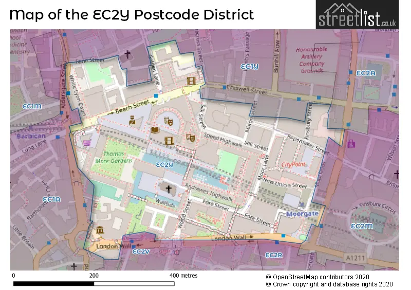
The EC2Y Postcode shares a border with EC2V (LONDON), EC1Y (ISLINGTON, LONDON) and EC2M (LONDON, ISLINGTON).
The primary settlement in the EC2Y postcode district is City of London. It is located in the City and County of the City of London. The most significant post town in this district is LONDON. City of London is the main settlement with the highest count, followed by Islington in Greater London.
For the district EC2Y, we have data on 3 postcode sectors. Here's a breakdown: The sector EC2Y 5, covers City Of London in City and County of the City of London. The sector EC2Y 8, covers City Of London in City and County of the City of London. The sector EC2Y 9, covers City Of London in City and County of the City of London. The sector EC2Y 9, covers Islington in Greater London.

Map of the EC2Y Postcode District
Explore the EC2Y postcode district by using our free interactive map.
When it comes to local government, postal geography often disregards political borders. However, for a breakdown in the EC2Y District: the district mostly encompasses the City and County of the City of London (84 postcodes), and finally, the Islington London Boro area (7 postcodes).
Recent House Sales in EC2Y
| Date | Price | Address |
|---|---|---|
| 22/09/2023 | £400,000 | Fann Street, London, EC2Y 8DY |
| 19/09/2023 | £535,000 | Moor Lane, London, EC2Y 9AP |
| 15/09/2023 | £550,000 | Moor Lane, London, EC2Y 9AP |
| 01/09/2023 | £700,000 | Frobisher Crescent, London, EC2Y 8HD |
| 31/08/2023 | £515,000 | Barbican, London, EC2Y 8DL |
| 31/08/2023 | £750,000 | Barbican, London, EC2Y 8DL |
| 28/08/2023 | £535,000 | Moor Lane, London, EC2Y 9AP |
| 25/08/2023 | £950,000 | Barbican, London, EC2Y 8ND |
| 18/08/2023 | £550,000 | Barbican, London, EC2Y 8NQ |
| 16/08/2023 | £665,000 | Barbican, London, EC2Y 8BL |
Weather Forecast for EC2Y
Press Button to Show Forecast for City Of London Youth Hostel
| Time Period | Icon | Description | Temperature | Rain Probability | Wind |
|---|---|---|---|---|---|
| 00:00 to 03:00 | Cloudy | 7.0°C (feels like 5.0°C) | 5.00% | ENE 7 mph | |
| 03:00 to 06:00 | Cloudy | 6.0°C (feels like 4.0°C) | 5.00% | NE 7 mph | |
| 06:00 to 09:00 | Cloudy | 5.0°C (feels like 3.0°C) | 4.00% | NE 7 mph | |
| 09:00 to 12:00 | Cloudy | 8.0°C (feels like 6.0°C) | 4.00% | ENE 7 mph | |
| 12:00 to 15:00 | Cloudy | 11.0°C (feels like 9.0°C) | 11.00% | ENE 7 mph | |
| 15:00 to 18:00 | Cloudy | 11.0°C (feels like 10.0°C) | 13.00% | ENE 7 mph | |
| 18:00 to 21:00 | Cloudy | 10.0°C (feels like 9.0°C) | 13.00% | E 7 mph | |
| 21:00 to 00:00 | Cloudy | 8.0°C (feels like 6.0°C) | 11.00% | E 7 mph |
Press Button to Show Forecast for City Of London Youth Hostel
| Time Period | Icon | Description | Temperature | Rain Probability | Wind |
|---|---|---|---|---|---|
| 00:00 to 03:00 | Cloudy | 6.0°C (feels like 4.0°C) | 17.00% | ENE 7 mph | |
| 03:00 to 06:00 | Cloudy | 6.0°C (feels like 4.0°C) | 18.00% | NE 7 mph | |
| 06:00 to 09:00 | Cloudy | 6.0°C (feels like 4.0°C) | 17.00% | NE 7 mph | |
| 09:00 to 12:00 | Overcast | 10.0°C (feels like 8.0°C) | 18.00% | ENE 9 mph | |
| 12:00 to 15:00 | Cloudy | 12.0°C (feels like 10.0°C) | 14.00% | E 9 mph | |
| 15:00 to 18:00 | Light rain | 13.0°C (feels like 11.0°C) | 51.00% | E 11 mph | |
| 18:00 to 21:00 | Light rain | 11.0°C (feels like 9.0°C) | 54.00% | ENE 9 mph | |
| 21:00 to 00:00 | Light rain | 10.0°C (feels like 8.0°C) | 54.00% | ENE 11 mph |
Press Button to Show Forecast for City Of London Youth Hostel
| Time Period | Icon | Description | Temperature | Rain Probability | Wind |
|---|---|---|---|---|---|
| 00:00 to 03:00 | Heavy rain | 10.0°C (feels like 8.0°C) | 75.00% | NE 9 mph | |
| 03:00 to 06:00 | Light rain | 10.0°C (feels like 8.0°C) | 56.00% | ESE 9 mph | |
| 06:00 to 09:00 | Light rain | 10.0°C (feels like 8.0°C) | 50.00% | SE 7 mph | |
| 09:00 to 12:00 | Light rain shower (day) | 11.0°C (feels like 9.0°C) | 45.00% | SE 9 mph | |
| 12:00 to 15:00 | Heavy rain shower (day) | 13.0°C (feels like 11.0°C) | 61.00% | S 9 mph | |
| 15:00 to 18:00 | Light rain shower (day) | 14.0°C (feels like 12.0°C) | 39.00% | SSW 11 mph | |
| 18:00 to 21:00 | Partly cloudy (day) | 13.0°C (feels like 11.0°C) | 13.00% | SW 11 mph | |
| 21:00 to 00:00 | Cloudy | 11.0°C (feels like 9.0°C) | 9.00% | SSW 7 mph |
Where is the EC2Y Postcode District?
The postcode district EC2Y is located in the town of London. It is approximately 1.71 miles away from the center of London. The district is also close to several nearby towns, including Barbican to the North West (0.04 miles away), Holborn and Covent Garden to the West (0.78 miles away), Inner Temple to the South West (0.84 miles away), Islington to the North (2.03 miles away), and Hackney to the North East (2.39 miles away).
The district is within the post town of LONDON.
The sector has postcodes within the nation of England.
The EC2Y Postcode District is covers the following regions.
- Camden and City of London - Inner London - West - London
- Haringey and Islington - Inner London - East - London
| Postcode Sector | Delivery Office |
|---|
| E | C | 2 | Y | - | X | X | X |
| E | C | 2 | Y | Space | Numeric | Letter | Letter |
Tourist Attractions within the Postcode Area
We found 1 visitor attractions within the EC2Y postcode area
| Museum of London |
|---|
| Museums & Art Galleries |
| Museum and / or Art Gallery |
| View Museum of London on Google Maps |
Current Monthly Rental Prices
| # Bedrooms | Min Price | Max Price | Avg Price |
|---|---|---|---|
| £1,950 | £3,033 | £2,481 | |
| 1 | £2,275 | £3,293 | £2,800 |
| 2 | £2,925 | £7,995 | £4,138 |
| 3 | £15,000 | £17,117 | £15,457 |
Current House Prices
| # Bedrooms | Min Price | Max Price | Avg Price |
|---|---|---|---|
| £399,000 | £625,000 | £504,154 | |
| 1 | £495,000 | £999,950 | £775,495 |
| 2 | £650,000 | £1,800,000 | £1,142,273 |
| 3 | £1,995,000 | £3,000,000 | £2,748,750 |
| 4 | £1,499,950 | £2,350,000 | £1,924,975 |
Estate Agents who Operate in the EC2Y District
| Logo | Name | Brand Name | Address | Contact Number | Total Properties |
|---|---|---|---|---|---|
 | City, Barbican & Clerkenwell | Frank Harris & Co. | 87 Long Lane, London, EC1A 9ET | 020 7601 1919 | 16 |
 | Barbican | Hamilton Brooks | 73 Long Lane, London, EC1A 9ET | 020 3879 9126 | 9 |
 | London | Nicola Lee Limited | 1b Charterhouse Square, London, EC1M 6EE | 020 3840 3426 | 7 |
 | London | Scott City Residential | 122 Newgate Street London EC1A 7AA | 020 3870 7036 | 5 |
 | The City, Central London | JLL | The Walbrook Building, 25 Walbrook, London, EC4N 8AF | 020 3889 9029 | 5 |
| Type of Property | 2018 Average | 2018 Sales | 2017 Average | 2017 Sales | 2016 Average | 2016 Sales | 2015 Average | 2015 Sales |
|---|---|---|---|---|---|---|---|---|
| Detached | £0 | 0 | £0 | 0 | £0 | 0 | £0 | 0 |
| Semi-Detached | £0 | 0 | £0 | 0 | £0 | 0 | £0 | 0 |
| Terraced | £0 | 0 | £950,000 | 1 | £0 | 0 | £875,000 | 1 |
| Flats | £935,008 | 103 | £1,013,336 | 144 | £1,046,864 | 82 | £988,509 | 150 |