The EC3R postcode district is a postal district located in the EC London - EC postcode area with a population of 319 residents according to the 2021 England and Wales Census.
The area of the EC3R postcode district is 0.05 square miles which is 0.14 square kilometres or 34.94 acres.
Currently, the EC3R district has about 89 postcode units spread across 4 geographic postcode sectors.
Given that each sector allows for 400 unique postcode combinations, the district has a capacity of 1,600 postcodes. With 89 postcodes already in use, this leaves 1511 units available.
The EC3R postal code covers the settlement of LONDON.
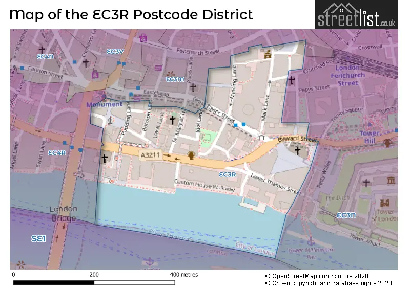
The postcode area has a boundary with Tidal Thames.
The EC3R Postcode shares a border with EC3M (LONDON), EC3N (LONDON) and EC4R (LONDON).
The primary settlement in the EC3R postcode district is City of London, located in the City and County of the City of London. The other significant settlement is Islington in Greater London. The most significant Postal Town in this district is London.
For the district EC3R, we have data on 4 postcode sectors. Here's a breakdown: The sector EC3R 5, covers City Of London in City and County of the City of London. The sector EC3R 6, covers City Of London in City and County of the City of London. The sector EC3R 6, covers Islington in Greater London. The sector EC3R 7, covers City Of London in City and County of the City of London. The sector EC3R 8, covers City Of London in City and County of the City of London.

Map of the EC3R Postcode District
Explore the EC3R postcode district by using our free interactive map.
When it comes to local government, postal geography often disregards political borders. However, for a breakdown in the EC3R District: the district mostly encompasses the City and County of the City of London (83 postcodes), and finally, the Islington London Boro area (3 postcodes).
Recent House Sales in EC3R
| Date | Price | Address |
|---|---|---|
| 26/06/2023 | £59,153,724 | St Mary At Hill, London, EC3R 8DY |
| 29/03/2023 | £40,000,000 | Great Tower Street, London, EC3R 5DJ |
| 13/03/2023 | £775,000 | Water Lane, London, EC3R 6AL |
| 08/11/2022 | £17,150,000 | Byward Street, London, EC3R 5BA |
| 28/10/2022 | £1,000,001 | Dunster Court, London, EC3R 7AH |
| 18/08/2022 | £4,590,000 | Water Lane, London, EC3R 6AP |
| 05/05/2022 | £2,840,000 | Water Lane, London, EC3R 6AP |
| 29/04/2022 | £610,000 | Monument Street, London, EC3R 8BT |
| 21/02/2022 | £1,700,000 | Water Lane, London, EC3R 6AL |
| 14/01/2022 | £4,680,000 | Water Lane, London, EC3R 6AL |
Weather Forecast for EC3R
Press Button to Show Forecast for City Of London
| Time Period | Icon | Description | Temperature | Rain Probability | Wind |
|---|---|---|---|---|---|
| 18:00 to 21:00 | Light rain | 9.0°C (feels like 8.0°C) | 51.00% | N 7 mph | |
| 21:00 to 00:00 | Cloudy | 8.0°C (feels like 6.0°C) | 11.00% | ENE 7 mph |
Press Button to Show Forecast for City Of London
| Time Period | Icon | Description | Temperature | Rain Probability | Wind |
|---|---|---|---|---|---|
| 00:00 to 03:00 | Cloudy | 7.0°C (feels like 5.0°C) | 5.00% | ENE 7 mph | |
| 03:00 to 06:00 | Cloudy | 6.0°C (feels like 4.0°C) | 5.00% | NE 7 mph | |
| 06:00 to 09:00 | Cloudy | 5.0°C (feels like 3.0°C) | 4.00% | NE 7 mph | |
| 09:00 to 12:00 | Cloudy | 8.0°C (feels like 6.0°C) | 4.00% | ENE 7 mph | |
| 12:00 to 15:00 | Cloudy | 11.0°C (feels like 9.0°C) | 11.00% | ENE 7 mph | |
| 15:00 to 18:00 | Cloudy | 11.0°C (feels like 10.0°C) | 13.00% | ENE 7 mph | |
| 18:00 to 21:00 | Cloudy | 10.0°C (feels like 9.0°C) | 13.00% | E 7 mph | |
| 21:00 to 00:00 | Cloudy | 8.0°C (feels like 6.0°C) | 11.00% | E 7 mph |
Press Button to Show Forecast for City Of London
| Time Period | Icon | Description | Temperature | Rain Probability | Wind |
|---|---|---|---|---|---|
| 00:00 to 03:00 | Cloudy | 6.0°C (feels like 4.0°C) | 17.00% | ENE 7 mph | |
| 03:00 to 06:00 | Cloudy | 5.0°C (feels like 4.0°C) | 18.00% | NE 7 mph | |
| 06:00 to 09:00 | Cloudy | 6.0°C (feels like 4.0°C) | 17.00% | NE 7 mph | |
| 09:00 to 12:00 | Overcast | 10.0°C (feels like 8.0°C) | 18.00% | ENE 9 mph | |
| 12:00 to 15:00 | Cloudy | 12.0°C (feels like 10.0°C) | 14.00% | E 9 mph | |
| 15:00 to 18:00 | Light rain | 13.0°C (feels like 10.0°C) | 51.00% | E 11 mph | |
| 18:00 to 21:00 | Light rain | 11.0°C (feels like 9.0°C) | 54.00% | ENE 9 mph | |
| 21:00 to 00:00 | Light rain | 10.0°C (feels like 8.0°C) | 54.00% | ENE 11 mph |
Press Button to Show Forecast for City Of London
| Time Period | Icon | Description | Temperature | Rain Probability | Wind |
|---|---|---|---|---|---|
| 00:00 to 03:00 | Heavy rain | 10.0°C (feels like 8.0°C) | 75.00% | NE 9 mph | |
| 03:00 to 06:00 | Light rain | 10.0°C (feels like 8.0°C) | 56.00% | ESE 9 mph | |
| 06:00 to 09:00 | Light rain | 10.0°C (feels like 8.0°C) | 50.00% | SE 7 mph | |
| 09:00 to 12:00 | Light rain shower (day) | 11.0°C (feels like 9.0°C) | 45.00% | SE 9 mph | |
| 12:00 to 15:00 | Heavy rain shower (day) | 13.0°C (feels like 11.0°C) | 61.00% | S 9 mph | |
| 15:00 to 18:00 | Light rain shower (day) | 14.0°C (feels like 12.0°C) | 39.00% | SSW 11 mph | |
| 18:00 to 21:00 | Partly cloudy (day) | 13.0°C (feels like 10.0°C) | 13.00% | SW 11 mph | |
| 21:00 to 00:00 | Cloudy | 11.0°C (feels like 9.0°C) | 9.00% | SSW 7 mph |
Where is the EC3R Postcode District?
The postcode district EC3R is located in the town of London. It is approximately 1.97 miles away from the center of London. The nearby towns to EC3R include Barbican, Inner Temple, New Cross, and St George's.
The district is within the post town of LONDON.
The sector has postcodes within the nation of England.
The EC3R Postcode District is covers the following regions.
- Camden and City of London - Inner London - West - London
- Haringey and Islington - Inner London - East - London
| Postcode Sector | Delivery Office |
|---|
| E | C | 3 | R | - | X | X | X |
| E | C | 3 | R | Space | Numeric | Letter | Letter |
Tourist Attractions within the Postcode Area
We found 1 visitor attractions within the EC3R postcode area
| Monument |
|---|
| Historic Properties |
| Historic Monument / Archaeological Site |
| View Monument on Google Maps |
Current Monthly Rental Prices
| # Bedrooms | Min Price | Max Price | Avg Price |
|---|---|---|---|
| £3,467 | £6,500 | £4,617 | |
| 1 | £2,100 | £6,067 | £4,188 |
| 2 | £3,100 | £10,183 | £6,739 |
| 3 | £18,200 | £36,833 | £23,174 |
Current House Prices
| # Bedrooms | Min Price | Max Price | Avg Price |
|---|---|---|---|
| 1 | £625,000 | £835,000 | £730,000 |
| 2 | £1,700,000 | £2,750,000 | £2,050,000 |
| 3 | £4,650,000 | £13,500,000 | £6,480,000 |
Estate Agents who Operate in the EC3R District
| Logo | Name | Brand Name | Address | Contact Number | Total Properties |
|---|---|---|---|---|---|
 | London | Right Now Residential | 108 Maltings Place, Tower Bridge Road, London, SE1 3LJ | 020 3909 0322 | 7 |
 | Wapping | Foxtons | Wapping High Street, London, E1W 2YN | 020 3840 3764 | 6 |
 | London | Goldstone Letting & Management Ltd | Floor 6, 28-30 Cornhill, City of London, EC3V 3NF | 07592 333692 | 4 |
 | Docklands | CBRE Residential | WeWork 30 Churchill Place London, E14 5RE | 020 3907 3038 | 4 |
 | London | Crown Home Buying & Letting | International House 1 St. Katharines Way London E1W 1UN | 020 3910 0884 | 4 |
| Type of Property | 2018 Average | 2018 Sales | 2017 Average | 2017 Sales | 2016 Average | 2016 Sales | 2015 Average | 2015 Sales |
|---|---|---|---|---|---|---|---|---|
| Detached | £0 | 0 | £0 | 0 | £0 | 0 | £0 | 0 |
| Semi-Detached | £0 | 0 | £0 | 0 | £0 | 0 | £0 | 0 |
| Terraced | £0 | 0 | £0 | 0 | £0 | 0 | £0 | 0 |
| Flats | £1,629,009 | 132 | £820,000 | 3 | £630,938 | 4 | £936,138 | 16 |