The EC3V postcode district is a postal district located in the EC London - EC postcode area with a population of 22 residents according to the 2021 England and Wales Census.
The area of the EC3V postcode district is 0.04 square miles which is 0.10 square kilometres or 25.49 acres.
Currently, the EC3V district has about 85 postcode units spread across 5 geographic postcode sectors.
Given that each sector allows for 400 unique postcode combinations, the district has a capacity of 2,000 postcodes. With 85 postcodes already in use, this leaves 1915 units available.
The EC3V postal code covers the settlement of LONDON.
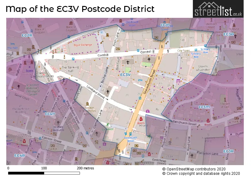
The EC3V Postcode shares a border with EC2N (LONDON), EC3A (LONDON), EC3M (LONDON) and EC2R (LONDON).
The primary settlement in the EC3V postcode district is City of London, located in the City and County of the City of London. This district also includes Islington, which is part of Greater London. The post town for this district is London.
For the district EC3V, we have data on 5 postcode sectors. Here's a breakdown: The sector EC3V 0, covers City Of London in City and County of the City of London. The sector EC3V 1, covers City Of London in City and County of the City of London. The sector EC3V 3, covers City Of London in City and County of the City of London. The sector EC3V 4, covers City Of London in City and County of the City of London. The sector EC3V 9, covers City Of London in City and County of the City of London.

Map of the EC3V Postcode District
Explore the EC3V postcode district by using our free interactive map.
When it comes to local government, postal geography often disregards political borders. However, for a breakdown in the EC3V District: the district mostly encompasses the City and County of the City of London area with a total of 79 postcodes.
Recent House Sales in EC3V
| Date | Price | Address |
|---|---|---|
| 14/10/2022 | £50,000 | Gracechurch Street, London, EC3V 0AS |
| 17/02/2021 | £1,500,000 | St Michaels Alley, London, EC3V 9DS |
| 09/02/2021 | £1,308,000 | Gracechurch Street, London, EC3V 0BT |
| 20/11/2020 | £585,000 | Cornhill, London, EC3V 3QQ |
| 08/09/2020 | £76,500,000 | Lombard Street, London, EC3V 9BQ |
| 11/03/2020 | £1,300,000 | Lombard Court, London, EC3V 9BJ |
| 07/01/2020 | £356,152 | Leadenhall Street, London, EC3V 4QT |
| 07/01/2020 | £351,932 | Leadenhall Street, London, EC3V 4QT |
| 07/01/2020 | £266,590 | Leadenhall Street, London, EC3V 4QT |
Weather Forecast for EC3V
Press Button to Show Forecast for City Of London
| Time Period | Icon | Description | Temperature | Rain Probability | Wind |
|---|---|---|---|---|---|
| 15:00 to 18:00 | Light rain | 11.0°C (feels like 9.0°C) | 70.00% | N 11 mph | |
| 18:00 to 21:00 | Cloudy | 10.0°C (feels like 8.0°C) | 48.00% | NNE 9 mph | |
| 21:00 to 00:00 | Clear night | 8.0°C (feels like 6.0°C) | 0.00% | N 9 mph |
Press Button to Show Forecast for City Of London
| Time Period | Icon | Description | Temperature | Rain Probability | Wind |
|---|---|---|---|---|---|
| 00:00 to 03:00 | Clear night | 6.0°C (feels like 4.0°C) | 0.00% | NNW 9 mph | |
| 03:00 to 06:00 | Clear night | 5.0°C (feels like 2.0°C) | 0.00% | NNW 9 mph | |
| 06:00 to 09:00 | Partly cloudy (day) | 5.0°C (feels like 2.0°C) | 1.00% | NNW 7 mph | |
| 09:00 to 12:00 | Cloudy | 8.0°C (feels like 5.0°C) | 4.00% | N 11 mph | |
| 12:00 to 15:00 | Cloudy | 10.0°C (feels like 8.0°C) | 4.00% | N 11 mph | |
| 15:00 to 18:00 | Overcast | 11.0°C (feels like 9.0°C) | 7.00% | N 11 mph | |
| 18:00 to 21:00 | Cloudy | 10.0°C (feels like 8.0°C) | 4.00% | N 9 mph | |
| 21:00 to 00:00 | Cloudy | 8.0°C (feels like 6.0°C) | 7.00% | NNE 7 mph |
Press Button to Show Forecast for City Of London
| Time Period | Icon | Description | Temperature | Rain Probability | Wind |
|---|---|---|---|---|---|
| 00:00 to 03:00 | Partly cloudy (night) | 7.0°C (feels like 5.0°C) | 2.00% | N 4 mph | |
| 03:00 to 06:00 | Cloudy | 6.0°C (feels like 4.0°C) | 4.00% | N 7 mph | |
| 06:00 to 09:00 | Cloudy | 5.0°C (feels like 3.0°C) | 7.00% | N 7 mph | |
| 09:00 to 12:00 | Overcast | 8.0°C (feels like 5.0°C) | 9.00% | NNE 9 mph | |
| 12:00 to 15:00 | Overcast | 10.0°C (feels like 8.0°C) | 9.00% | NNE 11 mph | |
| 15:00 to 18:00 | Overcast | 11.0°C (feels like 9.0°C) | 11.00% | NNE 11 mph | |
| 18:00 to 21:00 | Partly cloudy (day) | 10.0°C (feels like 8.0°C) | 4.00% | NNE 11 mph | |
| 21:00 to 00:00 | Clear night | 8.0°C (feels like 6.0°C) | 3.00% | NNE 9 mph |
Press Button to Show Forecast for City Of London
| Time Period | Icon | Description | Temperature | Rain Probability | Wind |
|---|---|---|---|---|---|
| 00:00 to 03:00 | Clear night | 6.0°C (feels like 4.0°C) | 2.00% | NNE 7 mph | |
| 03:00 to 06:00 | Clear night | 5.0°C (feels like 3.0°C) | 3.00% | N 4 mph | |
| 06:00 to 09:00 | Partly cloudy (day) | 5.0°C (feels like 3.0°C) | 2.00% | N 7 mph | |
| 09:00 to 12:00 | Cloudy | 8.0°C (feels like 6.0°C) | 8.00% | NNE 7 mph | |
| 12:00 to 15:00 | Cloudy | 10.0°C (feels like 9.0°C) | 10.00% | N 7 mph | |
| 15:00 to 18:00 | Overcast | 10.0°C (feels like 9.0°C) | 16.00% | NNW 7 mph | |
| 18:00 to 21:00 | Overcast | 10.0°C (feels like 8.0°C) | 18.00% | N 7 mph | |
| 21:00 to 00:00 | Light rain | 8.0°C (feels like 7.0°C) | 46.00% | NNE 4 mph |
Press Button to Show Forecast for City Of London
| Time Period | Icon | Description | Temperature | Rain Probability | Wind |
|---|---|---|---|---|---|
| 00:00 to 03:00 | Light rain shower (night) | 7.0°C (feels like 5.0°C) | 32.00% | ENE 4 mph | |
| 03:00 to 06:00 | Cloudy | 6.0°C (feels like 4.0°C) | 13.00% | N 4 mph | |
| 06:00 to 09:00 | Partly cloudy (day) | 6.0°C (feels like 5.0°C) | 10.00% | N 4 mph | |
| 09:00 to 12:00 | Cloudy | 9.0°C (feels like 7.0°C) | 10.00% | NNE 7 mph | |
| 12:00 to 15:00 | Overcast | 11.0°C (feels like 9.0°C) | 13.00% | NNE 9 mph | |
| 15:00 to 18:00 | Overcast | 11.0°C (feels like 9.0°C) | 16.00% | NNE 9 mph | |
| 18:00 to 21:00 | Cloudy | 11.0°C (feels like 9.0°C) | 8.00% | NNE 9 mph | |
| 21:00 to 00:00 | Partly cloudy (night) | 9.0°C (feels like 7.0°C) | 3.00% | NNE 7 mph |
Where is the EC3V Postcode District?
The postcode district EC3V is located in London. It is specifically situated in the LONDON district. Nearby towns include Barbican, Inner Temple, and Hackney, with distances of 0.59 miles to the North West, 1.04 miles to the West, and 2.68 miles to the North respectively. The postcode district is approximately 1.86 miles away from the center of London.
The district is within the post town of LONDON.
The sector has postcodes within the nation of England.
The EC3V Postcode District is covers the following regions.
- Camden and City of London - Inner London - West - London
- Haringey and Islington - Inner London - East - London
| Postcode Sector | Delivery Office |
|---|
| E | C | 3 | V | - | X | X | X |
| E | C | 3 | V | Space | Numeric | Letter | Letter |
Current Monthly Rental Prices
| # Bedrooms | Min Price | Max Price | Avg Price |
|---|---|---|---|
| 2 | £5,500 | £6,000 | £5,750 |
Current House Prices
| # Bedrooms | Min Price | Max Price | Avg Price |
|---|
Estate Agents who Operate in the EC3V District
| Logo | Name | Brand Name | Address | Contact Number | Total Properties |
|---|---|---|---|---|---|
 | Tower Bridge Lettings | Chestertons Estate Agents | 220 Tower Bridge Road, Tower Bridge, London, SE1 2UP | 020 3826 8110 | 1 |
 | London | Scraye | Great Titchfield Street, London, W1W 8AX | 020 3834 8234 | 1 |
| Type of Property | 2018 Average | 2018 Sales | 2017 Average | 2017 Sales | 2016 Average | 2016 Sales | 2015 Average | 2015 Sales |
|---|---|---|---|---|---|---|---|---|
| Detached | £0 | 0 | £0 | 0 | £0 | 0 | £0 | 0 |
| Semi-Detached | £0 | 0 | £0 | 0 | £0 | 0 | £0 | 0 |
| Terraced | £0 | 0 | £0 | 0 | £0 | 0 | £0 | 0 |
| Flats | £0 | 0 | £0 | 0 | £0 | 0 | £890,000 | 1 |
Hotels within the Postcode Area
We found 1 hotels and guest houses within the EC3V postcode area