The EH31 postcode district is a postal district located in the EH Edinburgh postcode area with a population of 2,568 residents according to the 2011 Scotland Census.
The area of the EH31 postcode district is 2.64 square miles which is 6.83 square kilometres or 1,688.51 acres.
Currently, the EH31 district has about 95 postcode units spread across 1 geographic postcode sectors.
Given that each sector allows for 400 unique postcode combinations, the district has a capacity of 400 postcodes. With 95 postcodes already in use, this leaves 305 units available.
The EH31 postal code covers the settlement of GULLANE.
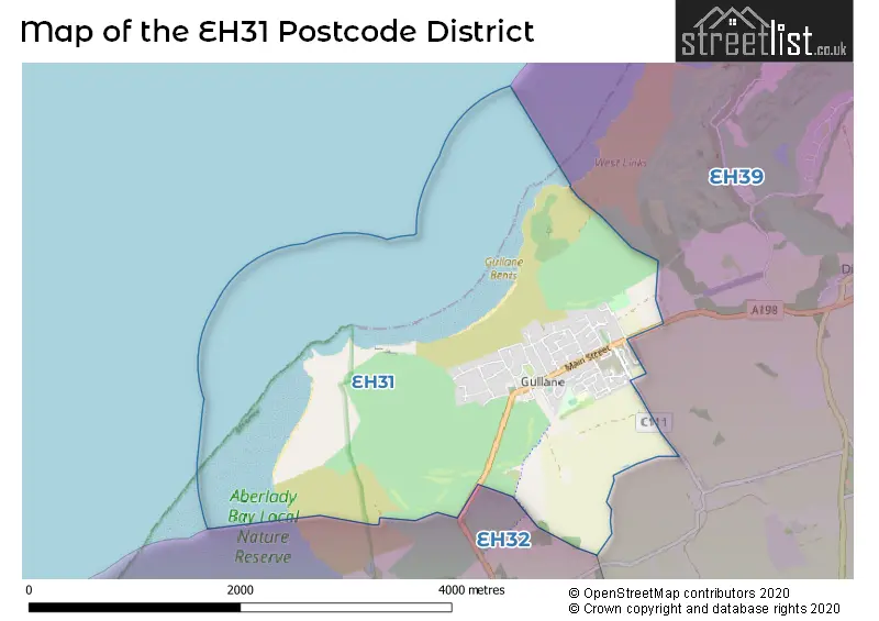
The postcode area has a boundary with Firth of Forth.
The EH31 Postcode shares a border with EH32 (PRESTONPANS, Port Seton, LONGNIDDRY) and EH39 (NORTH BERWICK, Dirleton, East Fortune).
The primary settlement in the EH31 postcode district is Gullane, located in the county of East Lothian in Scotland. The most significant Postal Town in this district is also Gullane.
For the district EH31, we have data on 1 postcode sectors. Here's a breakdown: The sector EH31 2, covers Gullane in East Lothian.
EH31 Postcode Sectors

Map of the EH31 Postcode District
Explore the EH31 postcode district by using our free interactive map.
When it comes to local government, postal geography often disregards political borders. However, for a breakdown in the EH31 District: the district mostly encompasses the East Lothian area with a total of 99 postcodes.
Weather Forecast for EH31
Press Button to Show Forecast for Gullane (Beach)
| Time Period | Icon | Description | Temperature | Rain Probability | Wind |
|---|---|---|---|---|---|
| 12:00 to 15:00 | Light rain shower (day) | 8.0°C (feels like 5.0°C) | 34.00% | N 9 mph | |
| 15:00 to 18:00 | Cloudy | 7.0°C (feels like 5.0°C) | 7.00% | NE 9 mph | |
| 18:00 to 21:00 | Cloudy | 6.0°C (feels like 4.0°C) | 5.00% | ENE 9 mph | |
| 21:00 to 00:00 | Cloudy | 4.0°C (feels like 2.0°C) | 4.00% | NE 4 mph |
Press Button to Show Forecast for Gullane (Beach)
| Time Period | Icon | Description | Temperature | Rain Probability | Wind |
|---|---|---|---|---|---|
| 00:00 to 03:00 | Partly cloudy (night) | 3.0°C (feels like 1.0°C) | 2.00% | NNE 4 mph | |
| 03:00 to 06:00 | Partly cloudy (night) | 3.0°C (feels like 1.0°C) | 1.00% | NNE 4 mph | |
| 06:00 to 09:00 | Partly cloudy (day) | 3.0°C (feels like 1.0°C) | 2.00% | NNW 7 mph | |
| 09:00 to 12:00 | Partly cloudy (day) | 7.0°C (feels like 5.0°C) | 2.00% | N 4 mph | |
| 12:00 to 15:00 | Cloudy | 8.0°C (feels like 7.0°C) | 8.00% | E 4 mph | |
| 15:00 to 18:00 | Partly cloudy (day) | 8.0°C (feels like 7.0°C) | 6.00% | SE 4 mph | |
| 18:00 to 21:00 | Cloudy | 7.0°C (feels like 6.0°C) | 8.00% | E 4 mph | |
| 21:00 to 00:00 | Cloudy | 5.0°C (feels like 3.0°C) | 7.00% | E 4 mph |
Press Button to Show Forecast for Gullane (Beach)
| Time Period | Icon | Description | Temperature | Rain Probability | Wind |
|---|---|---|---|---|---|
| 00:00 to 03:00 | Partly cloudy (night) | 3.0°C (feels like 2.0°C) | 1.00% | ENE 4 mph | |
| 03:00 to 06:00 | Partly cloudy (night) | 2.0°C (feels like 0.0°C) | 3.00% | NE 2 mph | |
| 06:00 to 09:00 | Mist | 3.0°C (feels like 2.0°C) | 14.00% | ENE 2 mph | |
| 09:00 to 12:00 | Partly cloudy (day) | 7.0°C (feels like 6.0°C) | 5.00% | SE 4 mph | |
| 12:00 to 15:00 | Cloudy | 9.0°C (feels like 8.0°C) | 10.00% | SE 7 mph | |
| 15:00 to 18:00 | Partly cloudy (day) | 9.0°C (feels like 7.0°C) | 9.00% | SE 9 mph | |
| 18:00 to 21:00 | Sunny day | 8.0°C (feels like 7.0°C) | 6.00% | ESE 7 mph | |
| 21:00 to 00:00 | Clear night | 5.0°C (feels like 3.0°C) | 5.00% | SE 7 mph |
Press Button to Show Forecast for Gullane (Beach)
| Time Period | Icon | Description | Temperature | Rain Probability | Wind |
|---|---|---|---|---|---|
| 00:00 to 03:00 | Partly cloudy (night) | 4.0°C (feels like 2.0°C) | 7.00% | E 7 mph | |
| 03:00 to 06:00 | Partly cloudy (night) | 4.0°C (feels like 2.0°C) | 8.00% | E 7 mph | |
| 06:00 to 09:00 | Partly cloudy (day) | 4.0°C (feels like 2.0°C) | 11.00% | NNE 7 mph | |
| 09:00 to 12:00 | Cloudy | 8.0°C (feels like 6.0°C) | 13.00% | NE 9 mph | |
| 12:00 to 15:00 | Cloudy | 10.0°C (feels like 8.0°C) | 14.00% | NE 9 mph | |
| 15:00 to 18:00 | Cloudy | 10.0°C (feels like 9.0°C) | 14.00% | E 7 mph | |
| 18:00 to 21:00 | Cloudy | 9.0°C (feels like 8.0°C) | 11.00% | E 7 mph | |
| 21:00 to 00:00 | Partly cloudy (night) | 8.0°C (feels like 5.0°C) | 8.00% | NNW 9 mph |
Where is the EH31 Postcode District?
The EH31 postcode district is located in Gullane, a town in Scotland. Gullane is situated near several other towns. To the east, there is North Berwick which is approximately 4.33 miles away. To the south-west, the town of Longniddry is located about 4.46 miles away. Further south-east, you will find Haddington, which is about 8.25 miles away. Additionally, Humbie is located to the south and is approximately 12.10 miles away. In terms of its relation to the center of London, Gullane is approximately 331.98 miles away.
The district is within the post town of GULLANE.
The sector has postcodes within the nation of Scotland.
The EH31 Postcode District is in the East Lothian and Midlothian region of Eastern Scotland within the Scotland.
Postcode Sectors within the EH31 District
| Postcode Sector | Delivery Office |
|---|---|
| EH31 2 | North Berwick Delivery Office |
| E | H | 3 | 1 | - | X | X | X |
| E | H | 3 | 1 | Space | Numeric | Letter | Letter |
Current Monthly Rental Prices
| # Bedrooms | Min Price | Max Price | Avg Price |
|---|---|---|---|
| 3 | £1,300 | £1,300 | £1,300 |
Current House Prices
| # Bedrooms | Min Price | Max Price | Avg Price |
|---|---|---|---|
| 1 | £270,000 | £270,000 | £270,000 |
| 2 | £220,000 | £220,000 | £220,000 |
| 4 | £465,000 | £600,000 | £515,000 |
Estate Agents who Operate in the EH31 District
| Logo | Name | Brand Name | Address | Contact Number | Total Properties |
|---|---|---|---|---|---|
 | North Berwick | Simpson & Marwick | 88 High Street, North Berwick, EH39 4HE | 01620 678806 | 2 |
 | Edinburgh | Rettie & Co | 4 Jamaica Street Edinburgh EH3 6HH | 1 | |
 | Edinburgh | Lindsays | Caledonian Exchange, 19A Canning Street Edinburgh EH3 8HE | 0131 381 1924 | 1 |
 | Edinburgh | Truscott Property | 10 Morningside Drive, Edinburgh, EH10 5LY | 0131 381 8912 | 1 |
 | covering Edinburgh | Purplebricks | Suite 7 First Floor Cranmore Drive Shirley Solihull B90 4RZ | 020 3834 8127 | 1 |