The EH32 postcode district is a postal district located in the EH Edinburgh postcode area with a population of 19,054 residents according to the 2011 Scotland Census.
The area of the EH32 postcode district is 14.59 square miles which is 37.80 square kilometres or 9,339.95 acres.
Currently, the EH32 district has about 515 postcode units spread across 2 geographic postcode sectors.
Given that each sector allows for 400 unique postcode combinations, the district has a capacity of 800 postcodes. With 515 postcodes already in use, this leaves 285 units available.
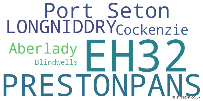
The largest settlement in the EH32 postal code is PRESTONPANS followed by Port Seton, and LONGNIDDRY.
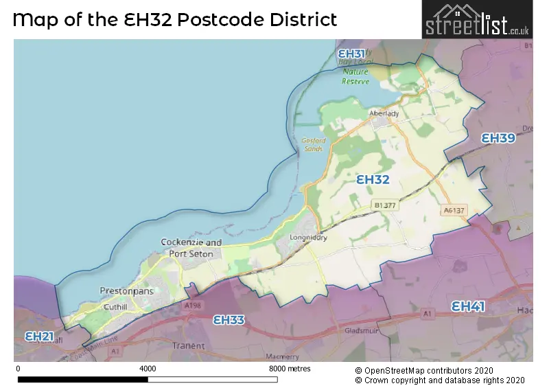
The postcode area has a boundary with Firth of Forth.
The EH32 Postcode shares a border with EH21 (MUSSELBURGH, Wallyford, Whitecraig), EH31 (GULLANE), EH33 (TRANENT, Macmerry, Elphinstone), EH41 (HADDINGTON, Gifford) and EH39 (NORTH BERWICK, Dirleton, East Fortune).
The primary settlement in the EH32 postcode district is Longniddry, located in the county of East Lothian, Scotland. Other significant settlements include Prestonpans and Aberlady which are also in East Lothian. The most significant post town in this postcode district is Prestonpans.
For the district EH32, we have data on 3 postcode sectors. Here's a breakdown: The sector EH32 0, covers Port Seton and Longniddry and Aberlady and Cockenzie in East Lothian. The sector EH32 2 is non-geographic. It's often designated for PO Boxes, large organisations, or special services. The sector EH32 9, covers Prestonpans in East Lothian.

Map of the EH32 Postcode District
Explore the EH32 postcode district by using our free interactive map.
When it comes to local government, postal geography often disregards political borders. However, for a breakdown in the EH32 District: the district mostly encompasses the East Lothian area with a total of 541 postcodes.
Weather Forecast for EH32
Press Button to Show Forecast for Longniddry (Beach)
| Time Period | Icon | Description | Temperature | Rain Probability | Wind |
|---|---|---|---|---|---|
| 00:00 to 03:00 | Partly cloudy (night) | 4.0°C (feels like 2.0°C) | 0.00% | NE 4 mph | |
| 03:00 to 06:00 | Cloudy | 4.0°C (feels like 1.0°C) | 4.00% | NW 9 mph | |
| 06:00 to 09:00 | Partly cloudy (day) | 4.0°C (feels like 1.0°C) | 2.00% | NNW 11 mph | |
| 09:00 to 12:00 | Partly cloudy (day) | 7.0°C (feels like 4.0°C) | 8.00% | N 9 mph | |
| 12:00 to 15:00 | Cloudy | 7.0°C (feels like 5.0°C) | 9.00% | N 9 mph | |
| 15:00 to 18:00 | Cloudy | 8.0°C (feels like 5.0°C) | 7.00% | NE 9 mph | |
| 18:00 to 21:00 | Partly cloudy (day) | 6.0°C (feels like 4.0°C) | 2.00% | ENE 9 mph | |
| 21:00 to 00:00 | Cloudy | 4.0°C (feels like 3.0°C) | 4.00% | NE 4 mph |
Press Button to Show Forecast for Longniddry (Beach)
| Time Period | Icon | Description | Temperature | Rain Probability | Wind |
|---|---|---|---|---|---|
| 00:00 to 03:00 | Partly cloudy (night) | 3.0°C (feels like 1.0°C) | 2.00% | NNE 4 mph | |
| 03:00 to 06:00 | Cloudy | 2.0°C (feels like 0.0°C) | 5.00% | NNE 4 mph | |
| 06:00 to 09:00 | Partly cloudy (day) | 3.0°C (feels like 1.0°C) | 2.00% | NNW 4 mph | |
| 09:00 to 12:00 | Partly cloudy (day) | 6.0°C (feels like 5.0°C) | 2.00% | N 7 mph | |
| 12:00 to 15:00 | Cloudy | 8.0°C (feels like 7.0°C) | 8.00% | ENE 4 mph | |
| 15:00 to 18:00 | Partly cloudy (day) | 8.0°C (feels like 7.0°C) | 6.00% | SE 4 mph | |
| 18:00 to 21:00 | Cloudy | 7.0°C (feels like 6.0°C) | 8.00% | E 4 mph | |
| 21:00 to 00:00 | Cloudy | 5.0°C (feels like 3.0°C) | 7.00% | E 4 mph |
Press Button to Show Forecast for Longniddry (Beach)
| Time Period | Icon | Description | Temperature | Rain Probability | Wind |
|---|---|---|---|---|---|
| 00:00 to 03:00 | Partly cloudy (night) | 3.0°C (feels like 2.0°C) | 1.00% | ENE 4 mph | |
| 03:00 to 06:00 | Mist | 2.0°C (feels like 0.0°C) | 14.00% | NE 2 mph | |
| 06:00 to 09:00 | Mist | 3.0°C (feels like 2.0°C) | 14.00% | ENE 2 mph | |
| 09:00 to 12:00 | Partly cloudy (day) | 7.0°C (feels like 6.0°C) | 5.00% | SE 4 mph | |
| 12:00 to 15:00 | Cloudy | 10.0°C (feels like 8.0°C) | 10.00% | SE 7 mph | |
| 15:00 to 18:00 | Partly cloudy (day) | 9.0°C (feels like 7.0°C) | 9.00% | SE 9 mph | |
| 18:00 to 21:00 | Sunny day | 8.0°C (feels like 7.0°C) | 6.00% | ESE 7 mph | |
| 21:00 to 00:00 | Clear night | 5.0°C (feels like 3.0°C) | 5.00% | SE 7 mph |
Press Button to Show Forecast for Longniddry (Beach)
| Time Period | Icon | Description | Temperature | Rain Probability | Wind |
|---|---|---|---|---|---|
| 00:00 to 03:00 | Partly cloudy (night) | 4.0°C (feels like 2.0°C) | 8.00% | E 7 mph | |
| 03:00 to 06:00 | Partly cloudy (night) | 4.0°C (feels like 2.0°C) | 9.00% | E 7 mph | |
| 06:00 to 09:00 | Partly cloudy (day) | 4.0°C (feels like 2.0°C) | 11.00% | NNE 7 mph | |
| 09:00 to 12:00 | Cloudy | 8.0°C (feels like 6.0°C) | 12.00% | NE 9 mph | |
| 12:00 to 15:00 | Cloudy | 10.0°C (feels like 8.0°C) | 14.00% | NE 9 mph | |
| 15:00 to 18:00 | Cloudy | 10.0°C (feels like 9.0°C) | 14.00% | E 7 mph | |
| 18:00 to 21:00 | Cloudy | 9.0°C (feels like 8.0°C) | 11.00% | E 7 mph | |
| 21:00 to 00:00 | Partly cloudy (night) | 8.0°C (feels like 5.0°C) | 8.00% | NNW 9 mph |
Where is the EH32 Postcode District?
The EH32 postcode district is located in Prestonpans, a town in East Lothian, Scotland. It is surrounded by several nearby towns, including Longniddry to the southwest (0.65 miles away), Gullane to the northeast (5.7 miles away), Haddington to the southeast (6.7 miles away), East Linton to the east (8 miles away), and Humbie to the south (8.7 miles away). Additionally, the distance from Prestonpans to the center of London is approximately 329.33 miles.
The district covers the post towns of PRESTONPANS.
The sector has postcodes within the nation of Scotland.
The EH32 Postcode District is in the East Lothian and Midlothian region of Eastern Scotland within the Scotland.
| Postcode Sector | Delivery Office |
|---|---|
| EH32 0 | Prestonpans Delivery Office |
| EH32 9 | Prestonpans Delivery Office |
| E | H | 3 | 2 | - | X | X | X |
| E | H | 3 | 2 | Space | Numeric | Letter | Letter |
Current Monthly Rental Prices
| # Bedrooms | Min Price | Max Price | Avg Price |
|---|
Current House Prices
| # Bedrooms | Min Price | Max Price | Avg Price |
|---|---|---|---|
| 1 | £132,500 | £135,000 | £133,750 |
| 2 | £155,000 | £242,000 | £202,217 |
| 3 | £140,000 | £635,000 | £288,455 |
| 4 | £275,000 | £1,500,000 | £509,285 |
| 5 | £450,000 | £1,650,000 | £820,000 |
Estate Agents who Operate in the EH32 District
| Logo | Name | Brand Name | Address | Contact Number | Total Properties |
|---|---|---|---|---|---|
 | North Berwick | Simpson & Marwick | 88 High Street, North Berwick, EH39 4HE | 01620 678806 | 4 |
 | Scotland | Keller Williams | 17 Fitzroy Place Glasgow G3 7RW | 03332 224360 | 4 |
 | Scotland Head Office | MOV8 Real Estate | 6 Redheughs Rigg Edinburgh EH12 9DQ | 03456 460208 | 3 |
 | Edinburgh | Clyde Property | 48/50 Morningside Road, Edinburgh, EH10 4BZ | 0131 381 3598 | 3 |
 | Edinburgh | A Annan Solicitors & Estate Agents | 266/268 Portobello High Street, Edinburgh, EH15 2AT | 01309 250468 | 2 |