The EH34 postcode district is a postal district located in the EH Edinburgh postcode area with a population of 2,540 residents according to the 2011 Scotland Census.
The area of the EH34 postcode district is 14.05 square miles which is 36.40 square kilometres or 8,993.71 acres.
Currently, the EH34 district has about 87 postcode units spread across 1 geographic postcode sectors.
Given that each sector allows for 400 unique postcode combinations, the district has a capacity of 400 postcodes. With 87 postcodes already in use, this leaves 313 units available.
The EH34 postal code covers the settlement of Pencaitland.
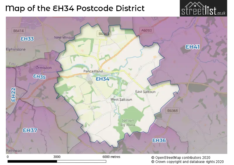
The EH34 Postcode shares a border with EH36 (HUMBIE), EH35 (Ormiston), EH33 (TRANENT, Macmerry, Elphinstone) and EH41 (HADDINGTON, Gifford).
In the EH34 postcode district in East Lothian, the primary settlement is Pencaitland. The most significant post town in this postcode district is Tranent.
For the district EH34, we have data on 1 postcode sectors. Here's a breakdown: The sector EH34 5, covers Pencaitland in East Lothian.
EH34 Postcode Sectors


Map of the EH34 Postcode District
Explore the EH34 postcode district by using our free interactive map.
When it comes to local government, postal geography often disregards political borders. However, for a breakdown in the EH34 District: the district mostly encompasses the East Lothian area with a total of 88 postcodes.
Weather Forecast for EH34
Press Button to Show Forecast for Tranent
| Time Period | Icon | Description | Temperature | Rain Probability | Wind |
|---|---|---|---|---|---|
| 21:00 to 00:00 | Cloudy | 6.0°C (feels like 4.0°C) | 4.00% | NE 7 mph |
Press Button to Show Forecast for Tranent
| Time Period | Icon | Description | Temperature | Rain Probability | Wind |
|---|---|---|---|---|---|
| 00:00 to 03:00 | Cloudy | 5.0°C (feels like 3.0°C) | 4.00% | ENE 4 mph | |
| 03:00 to 06:00 | Cloudy | 5.0°C (feels like 3.0°C) | 4.00% | SSE 4 mph | |
| 06:00 to 09:00 | Cloudy | 5.0°C (feels like 3.0°C) | 4.00% | S 4 mph | |
| 09:00 to 12:00 | Cloudy | 7.0°C (feels like 5.0°C) | 4.00% | NE 4 mph | |
| 12:00 to 15:00 | Cloudy | 8.0°C (feels like 7.0°C) | 7.00% | NNE 4 mph | |
| 15:00 to 18:00 | Cloudy | 10.0°C (feels like 9.0°C) | 5.00% | SE 2 mph | |
| 18:00 to 21:00 | Cloudy | 9.0°C (feels like 8.0°C) | 9.00% | SE 4 mph | |
| 21:00 to 00:00 | Cloudy | 8.0°C (feels like 6.0°C) | 10.00% | S 4 mph |
Press Button to Show Forecast for Tranent
| Time Period | Icon | Description | Temperature | Rain Probability | Wind |
|---|---|---|---|---|---|
| 00:00 to 03:00 | Overcast | 7.0°C (feels like 5.0°C) | 20.00% | S 4 mph | |
| 03:00 to 06:00 | Cloudy | 6.0°C (feels like 5.0°C) | 46.00% | SSW 4 mph | |
| 06:00 to 09:00 | Cloudy | 6.0°C (feels like 5.0°C) | 9.00% | SSW 2 mph | |
| 09:00 to 12:00 | Cloudy | 8.0°C (feels like 7.0°C) | 9.00% | N 2 mph | |
| 12:00 to 15:00 | Overcast | 10.0°C (feels like 9.0°C) | 13.00% | ENE 4 mph | |
| 15:00 to 18:00 | Overcast | 11.0°C (feels like 10.0°C) | 8.00% | ESE 4 mph | |
| 18:00 to 21:00 | Overcast | 10.0°C (feels like 9.0°C) | 8.00% | ESE 4 mph | |
| 21:00 to 00:00 | Overcast | 8.0°C (feels like 7.0°C) | 9.00% | SSE 4 mph |
Press Button to Show Forecast for Tranent
| Time Period | Icon | Description | Temperature | Rain Probability | Wind |
|---|---|---|---|---|---|
| 00:00 to 03:00 | Cloudy | 8.0°C (feels like 7.0°C) | 8.00% | SE 2 mph | |
| 03:00 to 06:00 | Cloudy | 7.0°C (feels like 6.0°C) | 6.00% | NW 2 mph | |
| 06:00 to 09:00 | Cloudy | 8.0°C (feels like 7.0°C) | 9.00% | NW 2 mph | |
| 09:00 to 12:00 | Overcast | 10.0°C (feels like 9.0°C) | 9.00% | NNW 4 mph | |
| 12:00 to 15:00 | Overcast | 12.0°C (feels like 11.0°C) | 8.00% | NNE 4 mph | |
| 15:00 to 18:00 | Cloudy | 12.0°C (feels like 12.0°C) | 6.00% | NE 4 mph | |
| 18:00 to 21:00 | Cloudy | 11.0°C (feels like 11.0°C) | 9.00% | E 4 mph | |
| 21:00 to 00:00 | Overcast | 9.0°C (feels like 8.0°C) | 11.00% | ENE 4 mph |
Press Button to Show Forecast for Tranent
| Time Period | Icon | Description | Temperature | Rain Probability | Wind |
|---|---|---|---|---|---|
| 00:00 to 03:00 | Cloudy | 7.0°C (feels like 6.0°C) | 7.00% | ENE 7 mph | |
| 03:00 to 06:00 | Cloudy | 7.0°C (feels like 4.0°C) | 7.00% | NNE 7 mph | |
| 06:00 to 09:00 | Cloudy | 6.0°C (feels like 4.0°C) | 7.00% | N 7 mph | |
| 09:00 to 12:00 | Cloudy | 8.0°C (feels like 6.0°C) | 9.00% | NNE 9 mph | |
| 12:00 to 15:00 | Cloudy | 10.0°C (feels like 8.0°C) | 5.00% | NNE 9 mph | |
| 15:00 to 18:00 | Cloudy | 11.0°C (feels like 9.0°C) | 5.00% | NE 7 mph | |
| 18:00 to 21:00 | Partly cloudy (day) | 10.0°C (feels like 8.0°C) | 2.00% | ENE 7 mph | |
| 21:00 to 00:00 | Partly cloudy (night) | 7.0°C (feels like 5.0°C) | 2.00% | ENE 7 mph |
Where is the EH34 Postcode District?
The postcode district EH34 is located in Tranent, a town in Scotland. Tranent is nearby several other towns, including Humbie to the south, Pathhead to the southwest, Longniddry to the north, Prestonpans to the northwest, Haddington to the east, and Dalkeith to the west. The distance from Tranent to the centre of London is approximately 324.15 miles.
The district is within the post town of TRANENT.
The sector has postcodes within the nation of Scotland.
The EH34 Postcode District is in the East Lothian and Midlothian region of Eastern Scotland within the Scotland.
Postcode Sectors within the EH34 District
| Postcode Sector | Delivery Office |
|---|---|
| EH34 5 | Tranent Delivery Office |
| E | H | 3 | 4 | - | X | X | X |
| E | H | 3 | 4 | Space | Numeric | Letter | Letter |
Current Monthly Rental Prices
| # Bedrooms | Min Price | Max Price | Avg Price |
|---|
Current House Prices
| # Bedrooms | Min Price | Max Price | Avg Price |
|---|---|---|---|
| 2 | £215,000 | £230,000 | £222,500 |
| 3 | £285,000 | £285,000 | £285,000 |
| 4 | £295,000 | £885,000 | £551,667 |
| 5 | £400,000 | £520,000 | £460,000 |
Estate Agents who Operate in the EH34 District
| Logo | Name | Brand Name | Address | Contact Number | Total Properties |
|---|---|---|---|---|---|
 | North Berwick | Simpson & Marwick | 88 High Street, North Berwick, EH39 4HE | 01620 678806 | 3 |
 | Kelso | Galbraith | 21 Woodmarket Kelso TD5 7AT | 01573 224244 | 1 |
 | Edinburgh | Warners Solicitors | 247B St. Johns Road, Edinburgh, EH12 7XD | 0131 381 3190 | 1 |
 | Edinburgh | Drummond Miller | Glenorchy House, 20 Union Street, Edinburgh, EH1 3LR | 0131 381 3029 | 1 |
 | Scotland Head Office | MOV8 Real Estate | 6 Redheughs Rigg Edinburgh EH12 9DQ | 03456 460208 | 1 |
Hotels within the Postcode Area
We found 1 hotels and guest houses within the EH34 postcode area
Winton House
Winton House, Pencaitland, East Lothian, Edinburgh, pencaitland, EH34 5AT.
View details