The EH47 postcode district is a postal district located in the EH Edinburgh postcode area with a population of 26,798 residents according to the 2011 Scotland Census.
The area of the EH47 postcode district is 25.72 square miles which is 66.62 square kilometres or 16,462.91 acres.
Currently, the EH47 district has about 732 postcode units spread across 4 geographic postcode sectors.
Given that each sector allows for 400 unique postcode combinations, the district has a capacity of 1,600 postcodes. With 732 postcodes already in use, this leaves 868 units available.
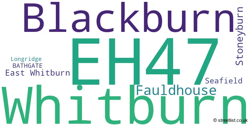
The largest settlement in the EH47 postal code is Whitburn followed by Blackburn, and Fauldhouse.
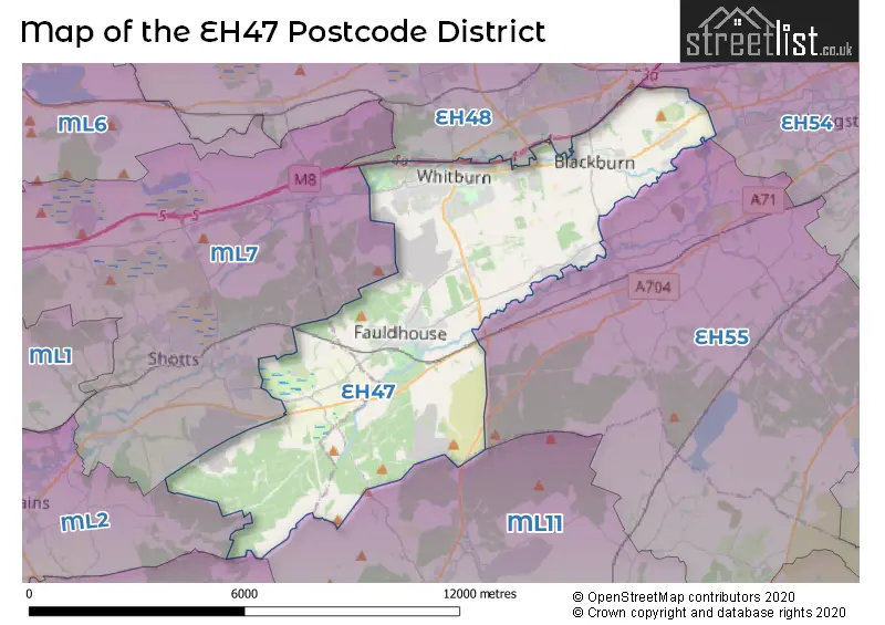
The EH47 Postcode shares a border with ML11 (LANARK, Lesmahagow, Forth), ML2 (WISHAW, Newmains, Overtown), ML8 (CARLUKE, Law, Crossford), EH54 (LIVINGSTON, Deans, Livingston Village), EH55 (WEST CALDER, Polbeth, Addiewell), ML7 (SHOTTS, Harthill, Salsburgh) and EH48 (BATHGATE, Armadale, Blackridge).
In the EH47 postcode district, the primary settlement is Bathgate, which is located in the county of West Lothian, Scotland. Other significant settlements in this district include East Whitburn, Blackburn, Seafield, Longridge, Stoneyburn, and Fauldhouse, all of which are also in West Lothian. The most significant post town in this district is Bathgate.
For the district EH47, we have data on 4 postcode sectors. Here's a breakdown: The sector EH47 0, covers Whitburn in West Lothian. The sector EH47 7, covers Blackburn and Seafield in West Lothian. The sector EH47 8, covers Whitburn and Stoneyburn in West Lothian. The sector EH47 9, covers Fauldhouse in West Lothian.

Map of the EH47 Postcode District
Explore the EH47 postcode district by using our free interactive map.
When it comes to local government, postal geography often disregards political borders. However, for a breakdown in the EH47 District: the district mostly encompasses the West Lothian (729 postcodes), and finally, the North Lanarkshire area (3 postcodes).
Weather Forecast for EH47
Press Button to Show Forecast for Whitburn
| Time Period | Icon | Description | Temperature | Rain Probability | Wind |
|---|---|---|---|---|---|
| 09:00 to 12:00 | Cloudy | 7.0°C (feels like 4.0°C) | 5.00% | NNW 11 mph | |
| 12:00 to 15:00 | Cloudy | 9.0°C (feels like 6.0°C) | 6.00% | NNW 11 mph | |
| 15:00 to 18:00 | Cloudy | 10.0°C (feels like 7.0°C) | 6.00% | NNW 13 mph | |
| 18:00 to 21:00 | Cloudy | 8.0°C (feels like 6.0°C) | 4.00% | N 9 mph | |
| 21:00 to 00:00 | Cloudy | 5.0°C (feels like 3.0°C) | 4.00% | N 7 mph |
Press Button to Show Forecast for Whitburn
| Time Period | Icon | Description | Temperature | Rain Probability | Wind |
|---|---|---|---|---|---|
| 00:00 to 03:00 | Cloudy | 4.0°C (feels like 2.0°C) | 5.00% | NNE 4 mph | |
| 03:00 to 06:00 | Cloudy | 2.0°C (feels like 1.0°C) | 5.00% | ESE 2 mph | |
| 06:00 to 09:00 | Cloudy | 3.0°C (feels like 2.0°C) | 5.00% | SSE 2 mph | |
| 09:00 to 12:00 | Partly cloudy (day) | 7.0°C (feels like 6.0°C) | 3.00% | NNW 4 mph | |
| 12:00 to 15:00 | Cloudy | 9.0°C (feels like 8.0°C) | 6.00% | NW 4 mph | |
| 15:00 to 18:00 | Overcast | 10.0°C (feels like 9.0°C) | 9.00% | WNW 7 mph | |
| 18:00 to 21:00 | Overcast | 10.0°C (feels like 9.0°C) | 9.00% | WNW 7 mph | |
| 21:00 to 00:00 | Cloudy | 8.0°C (feels like 6.0°C) | 4.00% | WSW 4 mph |
Press Button to Show Forecast for Whitburn
| Time Period | Icon | Description | Temperature | Rain Probability | Wind |
|---|---|---|---|---|---|
| 00:00 to 03:00 | Cloudy | 6.0°C (feels like 5.0°C) | 4.00% | SW 4 mph | |
| 03:00 to 06:00 | Cloudy | 6.0°C (feels like 5.0°C) | 8.00% | SW 2 mph | |
| 06:00 to 09:00 | Cloudy | 6.0°C (feels like 6.0°C) | 5.00% | SW 2 mph | |
| 09:00 to 12:00 | Partly cloudy (day) | 10.0°C (feels like 9.0°C) | 2.00% | NNW 4 mph | |
| 12:00 to 15:00 | Cloudy | 12.0°C (feels like 11.0°C) | 4.00% | NE 4 mph | |
| 15:00 to 18:00 | Cloudy | 13.0°C (feels like 12.0°C) | 4.00% | NE 4 mph | |
| 18:00 to 21:00 | Cloudy | 12.0°C (feels like 11.0°C) | 5.00% | ENE 4 mph | |
| 21:00 to 00:00 | Cloudy | 9.0°C (feels like 7.0°C) | 5.00% | SE 4 mph |
Press Button to Show Forecast for Whitburn
| Time Period | Icon | Description | Temperature | Rain Probability | Wind |
|---|---|---|---|---|---|
| 00:00 to 03:00 | Cloudy | 6.0°C (feels like 5.0°C) | 5.00% | SE 4 mph | |
| 03:00 to 06:00 | Cloudy | 6.0°C (feels like 5.0°C) | 6.00% | NE 2 mph | |
| 06:00 to 09:00 | Overcast | 7.0°C (feels like 6.0°C) | 8.00% | ENE 2 mph | |
| 09:00 to 12:00 | Cloudy | 10.0°C (feels like 9.0°C) | 7.00% | ENE 4 mph | |
| 12:00 to 15:00 | Cloudy | 12.0°C (feels like 10.0°C) | 10.00% | E 7 mph | |
| 15:00 to 18:00 | Cloudy | 12.0°C (feels like 11.0°C) | 13.00% | E 7 mph | |
| 18:00 to 21:00 | Cloudy | 12.0°C (feels like 11.0°C) | 6.00% | E 7 mph | |
| 21:00 to 00:00 | Cloudy | 9.0°C (feels like 8.0°C) | 6.00% | E 4 mph |
Where is the EH47 Postcode District?
The postcode district EH47 is located in Bathgate. Bathgate is a district town in Scotland. It is situated near several other towns. To the East of Bathgate is Crieff, which is approximately 2.54 miles away. To the West is Shotts, which is around 4.97 miles away. In the North East direction, you'll find Clydebank, which is about 5.92 miles away. Additionally, Carluke is situated to the South West, approximately 8.15 miles away from Bathgate. In terms of its distance from the centre of London, Bathgate is roughly 332.76 miles away.
The district is within the post town of BATHGATE.
The sector has postcodes within the nation of Scotland.
The EH47 Postcode District is in the West Lothian region of Eastern Scotland within the Scotland.
| Postcode Sector | Delivery Office |
|---|---|
| EH47 0 | Bathgate Delivery Office |
| EH47 7 | Bathgate Delivery Office |
| EH47 8 | Bathgate Delivery Office |
| EH47 9 | Bathgate Delivery Office |
| E | H | 4 | 7 | - | X | X | X |
| E | H | 4 | 7 | Space | Numeric | Letter | Letter |
Current Monthly Rental Prices
| # Bedrooms | Min Price | Max Price | Avg Price |
|---|---|---|---|
| 2 | £650 | £800 | £725 |
| 4 | £1,300 | £1,300 | £1,300 |
Current House Prices
| # Bedrooms | Min Price | Max Price | Avg Price |
|---|---|---|---|
| £70,000 | £280,000 | £150,000 | |
| 1 | £40,000 | £52,000 | £46,000 |
| 2 | £70,000 | £198,000 | £121,136 |
| 3 | £135,000 | £289,995 | £194,805 |
| 4 | £185,000 | £650,000 | £326,273 |
| 5 | £250,000 | £1,000,000 | £508,999 |
Estate Agents who Operate in the EH47 District
| Logo | Name | Brand Name | Address | Contact Number | Total Properties |
|---|---|---|---|---|---|
 | Whitburn | Brown & Co Properties Ltd | 17 Market Place, Whitburn, EH47 0EU | 01501 641962 | 12 |
 | Whitburn | BRIDGES PROPERTIES | 94D West Main Street Whitburn EH47 0QU | 01501 643098 | 7 |
 | West Lothian | Remax Property | Fairbairn Road, West Lothian, EH54 6TS | 01506 537260 | 5 |
 | Bathgate | Property Connections | 80 North Bridge Street Bathgate EH48 4PN | 01506 379843 | 4 |
 | Livingston | Slater Hogg & Howison | Unit 102 The Centre, Livingston, EH54 6HS | 01506 379894 | 2 |
Hotels within the Postcode Area
We found 4 hotels and guest houses within the EH47 postcode area
Best Western Glasgow Livingston Hilcroft Hotel, Livingston
East Main Street, Whitburn, whitburn, EH47 0JU.
View details