The EH48 postcode district is a postal district located in the EH Edinburgh postcode area with a population of 36,266 residents according to the 2011 Scotland Census.
The area of the EH48 postcode district is 31.42 square miles which is 81.37 square kilometres or 20,107.98 acres.
Currently, the EH48 district has about 922 postcode units spread across 4 geographic postcode sectors.
Given that each sector allows for 400 unique postcode combinations, the district has a capacity of 1,600 postcodes. With 922 postcodes already in use, this leaves 678 units available.
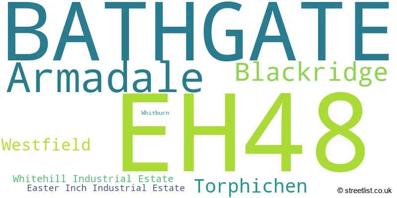
The largest settlement in the EH48 postal code is BATHGATE followed by Armadale, and Blackridge.
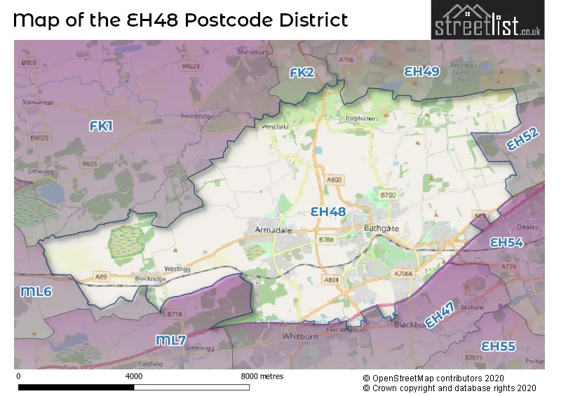
The EH48 Postcode shares a border with EH47 (Whitburn, Blackburn, Fauldhouse), EH54 (LIVINGSTON, Deans, Livingston Village), ML6 (AIRDRIE, Chapelhall, Plains), ML7 (SHOTTS, Harthill, Salsburgh), FK1 (FALKIRK, Camelon, Slamannan), EH52 (BROXBURN, Winchburgh, Uphall), FK2 (FALKIRK, Polmont, Maddiston) and EH49 (LINLITHGOW, Linlithgow Bridge, Bridgend).
The primary settlement in the EH48 postcode district is Bathgate, located in the county of West Lothian, Scotland. Other significant settlements in this district include Armadale, Easter Inch Industrial Estate, Whitehill Industrial Estate, Blackridge, Westfield, Whitburn, and Torphichen. The post town for this district is Bathgate.
For the district EH48, we have data on 5 postcode sectors. Here's a breakdown: The sector EH48 1, covers Bathgate in West Lothian. The sector EH48 2, covers Bathgate and Armadale in West Lothian. The sector EH48 3, covers Armadale and Blackridge in West Lothian. The sector EH48 4, covers Bathgate and Torphichen in West Lothian. The sector EH48 9 is non-geographic. It's often designated for PO Boxes, large organisations, or special services.

Map of the EH48 Postcode District
Explore the EH48 postcode district by using our free interactive map.
When it comes to local government, postal geography often disregards political borders. However, for a breakdown in the EH48 District: the district mostly encompasses the West Lothian area with a total of 922 postcodes.
Weather Forecast for EH48
Press Button to Show Forecast for Armadale
| Time Period | Icon | Description | Temperature | Rain Probability | Wind |
|---|---|---|---|---|---|
| 21:00 to 00:00 | Partly cloudy (night) | 7.0°C (feels like 4.0°C) | 4.00% | W 13 mph |
Press Button to Show Forecast for Armadale
| Time Period | Icon | Description | Temperature | Rain Probability | Wind |
|---|---|---|---|---|---|
| 00:00 to 03:00 | Cloudy | 7.0°C (feels like 3.0°C) | 5.00% | W 13 mph | |
| 03:00 to 06:00 | Cloudy | 6.0°C (feels like 2.0°C) | 5.00% | WNW 11 mph | |
| 06:00 to 09:00 | Cloudy | 6.0°C (feels like 2.0°C) | 5.00% | WNW 9 mph | |
| 09:00 to 12:00 | Cloudy | 7.0°C (feels like 4.0°C) | 9.00% | NNW 11 mph | |
| 12:00 to 15:00 | Overcast | 9.0°C (feels like 6.0°C) | 9.00% | NNW 13 mph | |
| 15:00 to 18:00 | Cloudy | 9.0°C (feels like 7.0°C) | 5.00% | NNW 13 mph | |
| 18:00 to 21:00 | Cloudy | 8.0°C (feels like 6.0°C) | 5.00% | N 9 mph | |
| 21:00 to 00:00 | Cloudy | 5.0°C (feels like 3.0°C) | 4.00% | N 7 mph |
Press Button to Show Forecast for Armadale
| Time Period | Icon | Description | Temperature | Rain Probability | Wind |
|---|---|---|---|---|---|
| 00:00 to 03:00 | Cloudy | 4.0°C (feels like 2.0°C) | 4.00% | N 4 mph | |
| 03:00 to 06:00 | Cloudy | 3.0°C (feels like 1.0°C) | 5.00% | NE 4 mph | |
| 06:00 to 09:00 | Cloudy | 3.0°C (feels like 2.0°C) | 4.00% | SW 4 mph | |
| 09:00 to 12:00 | Sunny day | 7.0°C (feels like 6.0°C) | 2.00% | N 4 mph | |
| 12:00 to 15:00 | Overcast | 9.0°C (feels like 8.0°C) | 10.00% | WNW 4 mph | |
| 15:00 to 18:00 | Overcast | 11.0°C (feels like 9.0°C) | 9.00% | W 7 mph | |
| 18:00 to 21:00 | Overcast | 10.0°C (feels like 9.0°C) | 8.00% | WSW 4 mph | |
| 21:00 to 00:00 | Cloudy | 8.0°C (feels like 6.0°C) | 5.00% | SW 7 mph |
Press Button to Show Forecast for Armadale
| Time Period | Icon | Description | Temperature | Rain Probability | Wind |
|---|---|---|---|---|---|
| 00:00 to 03:00 | Cloudy | 7.0°C (feels like 5.0°C) | 5.00% | S 4 mph | |
| 03:00 to 06:00 | Cloudy | 6.0°C (feels like 4.0°C) | 8.00% | SW 4 mph | |
| 06:00 to 09:00 | Cloudy | 6.0°C (feels like 5.0°C) | 7.00% | SW 4 mph | |
| 09:00 to 12:00 | Cloudy | 9.0°C (feels like 9.0°C) | 8.00% | S 2 mph | |
| 12:00 to 15:00 | Overcast | 12.0°C (feels like 11.0°C) | 7.00% | E 4 mph | |
| 15:00 to 18:00 | Overcast | 13.0°C (feels like 12.0°C) | 7.00% | ESE 4 mph | |
| 18:00 to 21:00 | Cloudy | 12.0°C (feels like 10.0°C) | 4.00% | ESE 7 mph | |
| 21:00 to 00:00 | Cloudy | 9.0°C (feels like 7.0°C) | 5.00% | ENE 7 mph |
Press Button to Show Forecast for Armadale
| Time Period | Icon | Description | Temperature | Rain Probability | Wind |
|---|---|---|---|---|---|
| 00:00 to 03:00 | Overcast | 7.0°C (feels like 6.0°C) | 8.00% | ENE 4 mph | |
| 03:00 to 06:00 | Cloudy | 6.0°C (feels like 5.0°C) | 5.00% | NE 4 mph | |
| 06:00 to 09:00 | Cloudy | 6.0°C (feels like 5.0°C) | 6.00% | NE 2 mph | |
| 09:00 to 12:00 | Cloudy | 9.0°C (feels like 8.0°C) | 6.00% | NE 4 mph | |
| 12:00 to 15:00 | Cloudy | 11.0°C (feels like 10.0°C) | 9.00% | NE 7 mph | |
| 15:00 to 18:00 | Cloudy | 12.0°C (feels like 11.0°C) | 9.00% | ENE 7 mph | |
| 18:00 to 21:00 | Cloudy | 12.0°C (feels like 11.0°C) | 6.00% | ESE 7 mph | |
| 21:00 to 00:00 | Cloudy | 9.0°C (feels like 7.0°C) | 7.00% | NE 7 mph |
Where is the EH48 Postcode District?
The EH48 postcode district is located in Bathgate. Bathgate is situated near several towns: - To the east, there is Clydebank, which is approximately 2.89 miles away. - To the south, there is Crieff, which is around 4.54 miles away. - To the northeast, there is Linlithgow, which is approximately 5.79 miles away. - To the southeast, there is West Calder, which is around 7.18 miles away. - To the north, there is Bo'ness, which is approximately 7.62 miles away. Additionally, Bathgate is located about 337.08 miles from the center of London.
The district is within the post town of BATHGATE.
The sector has postcodes within the nation of Scotland.
The EH48 Postcode District is in the West Lothian region of Eastern Scotland within the Scotland.
| Postcode Sector | Delivery Office |
|---|---|
| EH48 1 | Bathgate Delivery Office |
| EH48 2 | Bathgate Delivery Office |
| EH48 3 | Bathgate Delivery Office |
| EH48 4 | Bathgate Delivery Office |
| E | H | 4 | 8 | - | X | X | X |
| E | H | 4 | 8 | Space | Numeric | Letter | Letter |
Current Monthly Rental Prices
| # Bedrooms | Min Price | Max Price | Avg Price |
|---|---|---|---|
| £650 | £650 | £650 | |
| 1 | £639 | £639 | £639 |
| 2 | £750 | £1,200 | £915 |
| 4 | £1,395 | £1,395 | £1,395 |
Current House Prices
| # Bedrooms | Min Price | Max Price | Avg Price |
|---|---|---|---|
| £59,000 | £1,500,000 | £551,333 | |
| 1 | £60,000 | £109,000 | £85,750 |
| 2 | £84,995 | £275,000 | £134,502 |
| 3 | £90,000 | £280,000 | £195,641 |
| 4 | £210,000 | £525,000 | £324,444 |
| 5 | £285,000 | £1,400,000 | £631,250 |
| 6 | £420,000 | £1,050,000 | £735,000 |
Estate Agents who Operate in the EH48 District
| Logo | Name | Brand Name | Address | Contact Number | Total Properties |
|---|---|---|---|---|---|
 | Bathgate | Turpie & Co | 5-9 Edinburgh Road Edinburgh Road, Bathgate, EH48 1BA | 01506 539577 | 15 |
 | Whitburn | BRIDGES PROPERTIES | 94D West Main Street Whitburn EH47 0QU | 01501 643098 | 13 |
 | Bathgate | Property Connections | 80 North Bridge Street Bathgate EH48 4PN | 01506 379843 | 9 |
 | Bathgate | Castlebrae Sales and Letting Ltd | 7 Hopetoun Lane, Bathgate, EH48 1PP | 01506 379182 | 6 |
 | Whitburn | Brown & Co Properties Ltd | 17 Market Place, Whitburn, EH47 0EU | 01501 641962 | 5 |
Hotels within the Postcode Area
We found 6 hotels and guest houses within the EH48 postcode area
Bathgate Contractor and Business Apartment
14 Marjory Court, Bathgate, bathgate, EH48 1EZ.
View detailsTarrareoch Guest House
Tarrareoch Farm, Station Way, Armadale, Bathgate, bathgate, EH48 3BJ.
View details