The EH49 postcode district is a postal district located in the EH Edinburgh postcode area with a population of 16,851 residents according to the 2011 Scotland Census.
The area of the EH49 postcode district is 25.06 square miles which is 64.91 square kilometres or 16,040.02 acres.
Currently, the EH49 district has about 424 postcode units spread across 2 geographic postcode sectors.
Given that each sector allows for 400 unique postcode combinations, the district has a capacity of 800 postcodes. With 424 postcodes already in use, this leaves 376 units available.
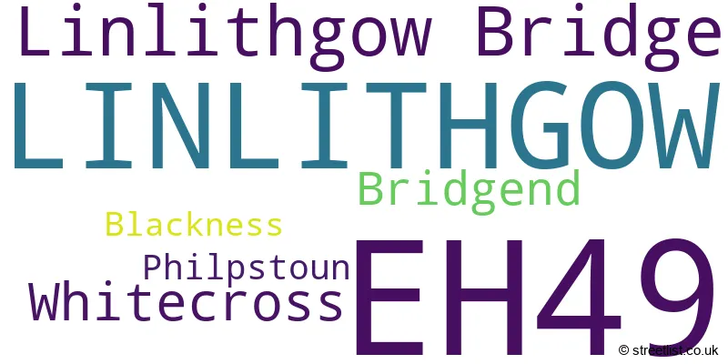
The largest settlement in the EH49 postal code is LINLITHGOW followed by Linlithgow Bridge, and Bridgend.
The postcode area has a boundary with Firth of Forth.
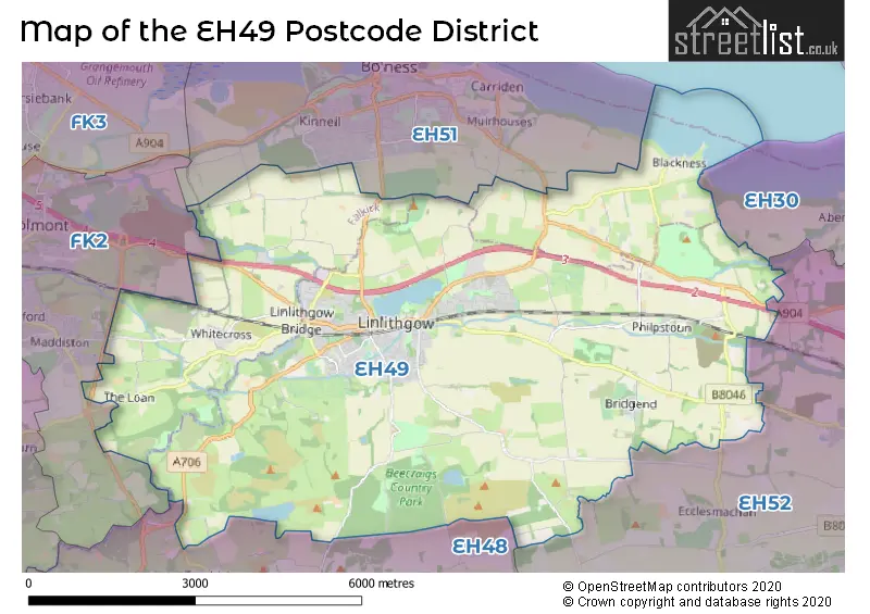
The EH49 Postcode shares a border with EH48 (BATHGATE, Armadale, Blackridge), EH30 (SOUTH QUEENSFERRY, Dalmeny, Craigiehall), EH52 (BROXBURN, Winchburgh, Uphall), FK2 (FALKIRK, Polmont, Maddiston) and EH51 (BO'NESS).
The primary settlement in the EH49 postcode district is Linlithgow, located in the county of West Lothian in Scotland. Other significant settlements in the district include Bridgend, Philpstoun, and Whitecross. The most significant post town in the district is Linlithgow.
For the district EH49, we have data on 3 postcode sectors. Here's a breakdown: The sector EH49 6, covers Linlithgow in West Lothian. The sector EH49 6, covers Whitecross in Stirling and Falkirk. The sector EH49 7, covers Linlithgow and Linlithgow Bridge in West Lothian. The sector EH49 9 is non-geographic. It's often designated for PO Boxes, large organisations, or special services.

Map of the EH49 Postcode District
Explore the EH49 postcode district by using our free interactive map.
When it comes to local government, postal geography often disregards political borders. However, for a breakdown in the EH49 District: the district mostly encompasses the West Lothian (376 postcodes), and finally, the Falkirk area (52 postcodes).
Weather Forecast for EH49
Press Button to Show Forecast for Linlithgow
| Time Period | Icon | Description | Temperature | Rain Probability | Wind |
|---|---|---|---|---|---|
| 15:00 to 18:00 | Cloudy | 10.0°C (feels like 8.0°C) | 5.00% | N 11 mph | |
| 18:00 to 21:00 | Cloudy | 9.0°C (feels like 7.0°C) | 4.00% | N 11 mph | |
| 21:00 to 00:00 | Cloudy | 6.0°C (feels like 5.0°C) | 7.00% | NNE 4 mph |
Press Button to Show Forecast for Linlithgow
| Time Period | Icon | Description | Temperature | Rain Probability | Wind |
|---|---|---|---|---|---|
| 00:00 to 03:00 | Cloudy | 6.0°C (feels like 4.0°C) | 4.00% | E 4 mph | |
| 03:00 to 06:00 | Cloudy | 5.0°C (feels like 3.0°C) | 4.00% | WNW 4 mph | |
| 06:00 to 09:00 | Cloudy | 5.0°C (feels like 4.0°C) | 3.00% | NW 4 mph | |
| 09:00 to 12:00 | Cloudy | 7.0°C (feels like 6.0°C) | 3.00% | NE 4 mph | |
| 12:00 to 15:00 | Cloudy | 9.0°C (feels like 9.0°C) | 4.00% | NNE 4 mph | |
| 15:00 to 18:00 | Overcast | 10.0°C (feels like 9.0°C) | 9.00% | NNW 7 mph | |
| 18:00 to 21:00 | Cloudy | 10.0°C (feels like 9.0°C) | 6.00% | SSW 4 mph | |
| 21:00 to 00:00 | Cloudy | 8.0°C (feels like 7.0°C) | 10.00% | ENE 4 mph |
Press Button to Show Forecast for Linlithgow
| Time Period | Icon | Description | Temperature | Rain Probability | Wind |
|---|---|---|---|---|---|
| 00:00 to 03:00 | Overcast | 7.0°C (feels like 6.0°C) | 12.00% | NE 4 mph | |
| 03:00 to 06:00 | Cloudy | 6.0°C (feels like 5.0°C) | 8.00% | NNE 2 mph | |
| 06:00 to 09:00 | Cloudy | 6.0°C (feels like 5.0°C) | 5.00% | NNE 2 mph | |
| 09:00 to 12:00 | Overcast | 8.0°C (feels like 8.0°C) | 8.00% | NE 2 mph | |
| 12:00 to 15:00 | Cloudy | 11.0°C (feels like 11.0°C) | 5.00% | ENE 2 mph | |
| 15:00 to 18:00 | Overcast | 12.0°C (feels like 11.0°C) | 8.00% | E 4 mph | |
| 18:00 to 21:00 | Overcast | 11.0°C (feels like 10.0°C) | 8.00% | SE 4 mph | |
| 21:00 to 00:00 | Cloudy | 9.0°C (feels like 8.0°C) | 7.00% | SE 4 mph |
Press Button to Show Forecast for Linlithgow
| Time Period | Icon | Description | Temperature | Rain Probability | Wind |
|---|---|---|---|---|---|
| 00:00 to 03:00 | Cloudy | 8.0°C (feels like 7.0°C) | 7.00% | N 2 mph | |
| 03:00 to 06:00 | Cloudy | 7.0°C (feels like 7.0°C) | 6.00% | NNW 2 mph | |
| 06:00 to 09:00 | Cloudy | 8.0°C (feels like 7.0°C) | 5.00% | NW 2 mph | |
| 09:00 to 12:00 | Cloudy | 11.0°C (feels like 10.0°C) | 5.00% | NNW 4 mph | |
| 12:00 to 15:00 | Overcast | 13.0°C (feels like 12.0°C) | 8.00% | N 4 mph | |
| 15:00 to 18:00 | Overcast | 14.0°C (feels like 13.0°C) | 9.00% | NNE 4 mph | |
| 18:00 to 21:00 | Cloudy | 13.0°C (feels like 12.0°C) | 7.00% | E 4 mph | |
| 21:00 to 00:00 | Cloudy | 10.0°C (feels like 9.0°C) | 5.00% | NE 4 mph |
Press Button to Show Forecast for Linlithgow
| Time Period | Icon | Description | Temperature | Rain Probability | Wind |
|---|---|---|---|---|---|
| 00:00 to 03:00 | Partly cloudy (night) | 8.0°C (feels like 7.0°C) | 3.00% | NE 4 mph | |
| 03:00 to 06:00 | Partly cloudy (night) | 7.0°C (feels like 5.0°C) | 3.00% | N 7 mph | |
| 06:00 to 09:00 | Cloudy | 7.0°C (feels like 5.0°C) | 6.00% | NNW 7 mph | |
| 09:00 to 12:00 | Cloudy | 9.0°C (feels like 7.0°C) | 5.00% | NNE 9 mph | |
| 12:00 to 15:00 | Cloudy | 11.0°C (feels like 10.0°C) | 5.00% | NNE 9 mph | |
| 15:00 to 18:00 | Cloudy | 12.0°C (feels like 11.0°C) | 5.00% | NNE 7 mph | |
| 18:00 to 21:00 | Partly cloudy (day) | 12.0°C (feels like 10.0°C) | 1.00% | NE 9 mph | |
| 21:00 to 00:00 | Clear night | 8.0°C (feels like 6.0°C) | 1.00% | NE 7 mph |
Where is the EH49 Postcode District?
The postcode district EH49 is located in the town of Linlithgow. Linlithgow is situated in close proximity to several nearby towns. To the north, there is Bo'ness, approximately 2.61 miles away. To the southeast lies Broxburn, which is around 4.50 miles away. Clydebank is situated to the south and is approximately 4.96 miles away. Grantown-on-Spey is the eastern neighboring town, located at a distance of 5.37 miles. Grangemouth, located to the northwest, is around 6.71 miles away. Finally, Bathgate is situated to the southwest, at a distance of approximately 7.16 miles. Additionally, the postcode district EH49 is about 339.66 miles away from the center of London.
The district is within the post town of LINLITHGOW.
The sector has postcodes within the nation of Scotland.
The EH49 Postcode District is covers the following regions.
- West Lothian - Eastern Scotland - Scotland
- Falkirk - Eastern Scotland - Scotland
| Postcode Sector | Delivery Office |
|---|---|
| EH49 6 | Linlithgow Delivery Office |
| EH49 7 | Linlithgow Delivery Office |
| E | H | 4 | 9 | - | X | X | X |
| E | H | 4 | 9 | Space | Numeric | Letter | Letter |
Current Monthly Rental Prices
| # Bedrooms | Min Price | Max Price | Avg Price |
|---|---|---|---|
| £1,325 | £1,325 | £1,325 | |
| 1 | £800 | £800 | £800 |
| 2 | £900 | £950 | £925 |
| 3 | £3,333 | £3,333 | £3,333 |
| 5 | £1,800 | £1,800 | £1,800 |
Current House Prices
| # Bedrooms | Min Price | Max Price | Avg Price |
|---|---|---|---|
| 1 | £155,000 | £175,000 | £163,333 |
| 2 | £148,000 | £325,000 | £230,000 |
| 3 | £140,000 | £420,000 | £293,333 |
| 4 | £295,000 | £675,000 | £450,833 |
| 5 | £370,000 | £1,250,000 | £762,777 |
Estate Agents who Operate in the EH49 District
| Logo | Name | Brand Name | Address | Contact Number | Total Properties |
|---|---|---|---|---|---|
 | Linlithgow | Halliday Homes | 23 High Street, Linlithgow, EH49 7AB | 01506 379855 | 7 |
 | Linlithgow | Paul Rolfe Sales and Lettings | 4 The Vennel Linlithgow EH49 7EX | 01506 379822 | 5 |
 | Linlithgow | Paul Rolfe Sales and Lettings | 4 The Vennel Linlithgow EH49 7EX | 01506 379837 | 4 |
 | Linlithgow | Paul Rolfe LUXE | 4 The Vennel, Linlithgow, EH49 7EX | 01506 533989 | 3 |
 | Linlithgow | Peterkin And Kidd | 8 High Street, Linlithgow, EH49 7AF | 01506 379838 | 3 |
Hotels within the Postcode Area
We found 6 hotels and guest houses within the EH49 postcode area