The EN10 6 postcode sector stands on the Essex and Hertfordshire border.
Did you know? According to the 2021 Census, the EN10 6 postcode sector is home to a bustling 11,438 residents!
Given that each sector allows for 400 unique postcode combinations. Letters C, I, K, M, O and V are not allowed in the last two letters of a postcode. With 224 postcodes already in use, this leaves 176 units available.
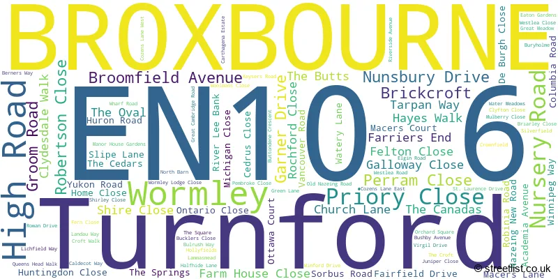
The largest settlement in the EN10 6 postal code is BROXBOURNE followed by Turnford, and Wormley.
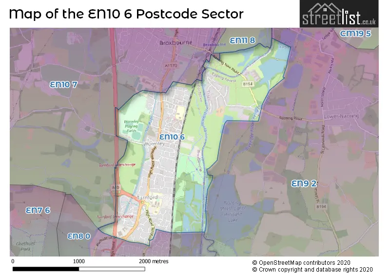
The EN10 6 Postcode shares a border with EN9 2 (WALTHAM ABBEY , NAZEING ), EN8 0 (CHESHUNT ), EN10 7 (BROXBOURNE) and EN11 8 (HODDESDON).
The sector is within the post town of BROXBOURNE.
EN10 6 is a postcode sector within the EN10 postcode district which is within the EN Enfield postcode area.
The Royal Mail delivery office for the EN10 6 postal sector is the Hoddesdon Delivery Office.
The area of the EN10 6 postcode sector is 1.67 square miles which is 4.33 square kilometres or 1,068.96 square acres.
Waterways within the EN10 6 postcode sector include the New River, Carthagena Lock, Kings Weir, Aqueduct Lock, River Lee Flood Relief Channel.

Map of the EN10 6 Postcode Sector
Explore the EN10 6 postcode sector by using our free interactive map.
| E | N | 1 | 0 | - | 6 | X | X |
| E | N | 1 | 0 | Space | 6 | Letter | Letter |
Official List of Streets
BROXBOURNE (92 Streets)
Wormley (4 Streets)
Unofficial Streets or Alternative Spellings
Nazeing
MEADGATE ROAD NAZEING ROAD ASHCROFT COURT BOARDWALK BURY HOLME CANADA LANE CHILWORTH GATE CROWN BRIDGE CURLEW COURT HADLEIGH COURT HIGH ROAD BROXBOURNE HIGH ROAD TURNFORD HIGH ROAD WORMLEY MARLEY COURT NAZEING OLD ROAD NEW RIVER PATH OAKLANDS GROVE REGENCY COURT RIVER LEE NAVIGATION TOWPATH RIVERSIDE MEWS THE LIMES THE NEW RIVER ARMS THE SIDINGS TURNFORD INTERCHANGE WATER COTTAGES WENTWORTH COTTAGES WEST SIDECheshunt
CHESHUNT WASH GREAT CAMBRIDGE ROAD HALFHIDE LANEWeather Forecast for EN10 6
Press Button to Show Forecast for Hoddesdon
| Time Period | Icon | Description | Temperature | Rain Probability | Wind |
|---|---|---|---|---|---|
| 09:00 to 12:00 | Cloudy | 9.0°C (feels like 7.0°C) | 7.00% | W 7 mph | |
| 12:00 to 15:00 | Light rain | 10.0°C (feels like 8.0°C) | 53.00% | WNW 11 mph | |
| 15:00 to 18:00 | Light rain | 10.0°C (feels like 8.0°C) | 50.00% | WNW 9 mph | |
| 18:00 to 21:00 | Cloudy | 8.0°C (feels like 6.0°C) | 9.00% | NNE 7 mph | |
| 21:00 to 00:00 | Cloudy | 6.0°C (feels like 5.0°C) | 7.00% | NE 4 mph |
Press Button to Show Forecast for Hoddesdon
| Time Period | Icon | Description | Temperature | Rain Probability | Wind |
|---|---|---|---|---|---|
| 00:00 to 03:00 | Cloudy | 5.0°C (feels like 3.0°C) | 4.00% | NE 4 mph | |
| 03:00 to 06:00 | Partly cloudy (night) | 3.0°C (feels like 1.0°C) | 5.00% | NE 4 mph | |
| 06:00 to 09:00 | Sunny day | 3.0°C (feels like 1.0°C) | 1.00% | NNE 4 mph | |
| 09:00 to 12:00 | Partly cloudy (day) | 8.0°C (feels like 6.0°C) | 1.00% | ENE 7 mph | |
| 12:00 to 15:00 | Cloudy | 10.0°C (feels like 9.0°C) | 9.00% | ENE 4 mph | |
| 15:00 to 18:00 | Overcast | 11.0°C (feels like 10.0°C) | 12.00% | NE 4 mph | |
| 18:00 to 21:00 | Cloudy | 9.0°C (feels like 8.0°C) | 10.00% | ENE 7 mph | |
| 21:00 to 00:00 | Cloudy | 6.0°C (feels like 4.0°C) | 9.00% | E 7 mph |
Press Button to Show Forecast for Hoddesdon
| Time Period | Icon | Description | Temperature | Rain Probability | Wind |
|---|---|---|---|---|---|
| 00:00 to 03:00 | Cloudy | 5.0°C (feels like 3.0°C) | 11.00% | ENE 4 mph | |
| 03:00 to 06:00 | Light rain | 4.0°C (feels like 2.0°C) | 44.00% | ENE 7 mph | |
| 06:00 to 09:00 | Cloudy | 5.0°C (feels like 2.0°C) | 19.00% | NE 7 mph | |
| 09:00 to 12:00 | Cloudy | 9.0°C (feels like 7.0°C) | 19.00% | ENE 9 mph | |
| 12:00 to 15:00 | Overcast | 11.0°C (feels like 9.0°C) | 19.00% | E 9 mph | |
| 15:00 to 18:00 | Cloudy | 12.0°C (feels like 10.0°C) | 18.00% | E 11 mph | |
| 18:00 to 21:00 | Cloudy | 11.0°C (feels like 9.0°C) | 23.00% | ENE 9 mph | |
| 21:00 to 00:00 | Light rain | 9.0°C (feels like 6.0°C) | 51.00% | NE 11 mph |
Press Button to Show Forecast for Hoddesdon
| Time Period | Icon | Description | Temperature | Rain Probability | Wind |
|---|---|---|---|---|---|
| 00:00 to 03:00 | Light rain | 9.0°C (feels like 6.0°C) | 51.00% | NE 9 mph | |
| 03:00 to 06:00 | Heavy rain | 9.0°C (feels like 7.0°C) | 75.00% | ESE 9 mph | |
| 06:00 to 09:00 | Light rain | 9.0°C (feels like 7.0°C) | 52.00% | SE 9 mph | |
| 09:00 to 12:00 | Heavy rain shower (day) | 11.0°C (feels like 9.0°C) | 58.00% | ESE 9 mph | |
| 12:00 to 15:00 | Light rain | 12.0°C (feels like 10.0°C) | 55.00% | S 9 mph | |
| 15:00 to 18:00 | Light rain shower (day) | 13.0°C (feels like 11.0°C) | 39.00% | SSW 11 mph | |
| 18:00 to 21:00 | Cloudy | 12.0°C (feels like 10.0°C) | 15.00% | SW 11 mph | |
| 21:00 to 00:00 | Partly cloudy (night) | 9.0°C (feels like 7.0°C) | 5.00% | SW 9 mph |
Schools and Places of Education Within the EN10 6 Postcode Sector
Longlands Primary School and Nursery
Community school
Nunsbury Drive, Broxbourne, Hertfordshire, EN10 6AG
Head: Miss Ashleigh Calver
Ofsted Rating: Outstanding
Inspection: 2018-10-18 (2016 days ago)
Website: Visit Longlands Primary School and Nursery Website
Phone: 01992462090
Number of Pupils: 220
Wormley CofE Primary School
Voluntary controlled school
Cozens Lane East, Broxbourne, Hertfordshire, EN10 6QA
Head: Mrs Tracy Gaiteri
Ofsted Rating: Good
Inspection: 2021-12-09 (868 days ago)
Website: Visit Wormley CofE Primary School Website
Phone: 01992303331
Number of Pupils: 444
House Prices in the EN10 6 Postcode Sector
| Type of Property | 2018 Average | 2018 Sales | 2017 Average | 2017 Sales | 2016 Average | 2016 Sales | 2015 Average | 2015 Sales |
|---|---|---|---|---|---|---|---|---|
| Detached | £612,083 | 12 | £561,213 | 17 | £636,500 | 18 | £504,229 | 26 |
| Semi-Detached | £401,532 | 31 | £430,874 | 24 | £417,944 | 18 | £366,875 | 28 |
| Terraced | £354,458 | 72 | £346,220 | 61 | £330,070 | 60 | £305,655 | 67 |
| Flats | £222,817 | 81 | £226,881 | 61 | £210,239 | 102 | £183,835 | 101 |
Important Postcodes EN10 6 in the Postcode Sector
EN10 6AG is the postcode for Longlands Junior Middle & Infant School, Nunsbury Drive, and Longlands Primary School & Nursery, Nunsbury Drive
EN10 6DX is the postcode for Wormley Community Centre, Fairfield Drive
EN10 6FD is the postcode for The Maples Health Centre, Vancouver Road
EN10 6LH is the postcode for Wormley C of E Primary School (VC), St. Laurence Drive, SOUTH BLOCK, Wormley C of E Primary School (VC), St. Laurence Drive, and NORTH BLOCK, Wormley C of E Primary School (VC), St. Laurence Drive
EN10 6QA is the postcode for SOUTH BLOCK, Wormley Primary School, Cozens Lane East, NORTH BLOCK, Wormley Primary School, Cozens Lane East, Wormley C of E Primary School, Cozens Lane East, and Wormley Primary School, Cozens Lane East
| The EN10 6 Sector is within these Local Authorities |
|
|---|---|
| The EN10 6 Sector is within these Counties |
|
| The EN10 6 Sector is within these Water Company Areas |
|