The EN11 postcode district is a postal district located in the EN Enfield postcode area with a population of 22,483 residents according to the 2021 England and Wales Census.
The area of the EN11 postcode district is 5.02 square miles which is 13.00 square kilometres or 3,213.51 acres.
Currently, the EN11 district has about 650 postcode units spread across 3 geographic postcode sectors.
Given that each sector allows for 400 unique postcode combinations, the district has a capacity of 1,200 postcodes. With 650 postcodes already in use, this leaves 550 units available.
The EN11 postal code covers the settlement of HODDESDON.
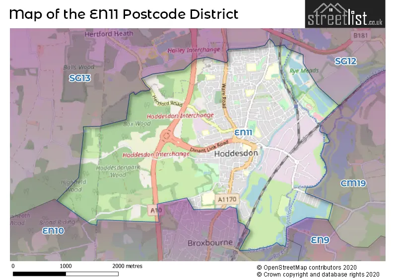
The EN11 Postcode shares a border with EN10 (BROXBOURNE, Turnford, Wormley), SG13 (HERTFORD, Hertford Heath, Bayford), CM19 (HARLOW, Roydon), EN9 (WALTHAM ABBEY) and SG12 (WARE, Stanstead Abbotts, Hunsdon).
The primary settlement in the EN11 postcode district is Hoddesdon, which is located in the county of Hertfordshire in England. Other significant settlements in this district include Hoddesdon, which is also located in Hertfordshire. The most significant post town in this district is Hoddesdon.
For the district EN11, we have data on 4 postcode sectors. Here's a breakdown: The sector EN11 0, covers Hoddesdon in Hertfordshire. The sector EN11 1 is non-geographic. It's often designated for PO Boxes, large organisations, or special services. The sector EN11 8, covers Hoddesdon in Hertfordshire. The sector EN11 9, covers Hoddesdon in Hertfordshire.

Map of the EN11 Postcode District
Explore the EN11 postcode district by using our free interactive map.
When it comes to local government, postal geography often disregards political borders. However, for a breakdown in the EN11 District: the district mostly encompasses the Broxbourne District (B) (637 postcodes), followed by the Epping Forest District area (12 postcodes), and finally, the East Hertfordshire District area (6 postcodes).
Recent House Sales in EN11
| Date | Price | Address |
|---|---|---|
| 28/09/2023 | £485,000 | Granville Gardens, Hoddesdon, EN11 9QD |
| 18/09/2023 | £620,000 | Lord Street, Hoddesdon, EN11 8NQ |
| 11/09/2023 | £625,000 | Avenue Road, Hoddesdon, EN11 0BA |
| 11/09/2023 | £445,000 | Admirals Walk, Hoddesdon, EN11 8AF |
| 08/09/2023 | £245,000 | Waterfall Close, Hoddesdon, EN11 9JX |
| 31/08/2023 | £365,000 | Dymokes Way, Hoddesdon, EN11 9NA |
| 25/08/2023 | £235,000 | Rose Vale, Hoddesdon, EN11 8FF |
| 25/08/2023 | £425,000 | Saffron Close, Hoddesdon, EN11 8QZ |
| 25/08/2023 | £275,000 | Castle Close, Hoddesdon, EN11 0ND |
| 25/08/2023 | £370,000 | Nursery Road, Hoddesdon, EN11 9LB |
Weather Forecast for EN11
Press Button to Show Forecast for Hoddesdon
| Time Period | Icon | Description | Temperature | Rain Probability | Wind |
|---|---|---|---|---|---|
| 18:00 to 21:00 | Overcast | 11.0°C (feels like 8.0°C) | 48.00% | W 13 mph | |
| 21:00 to 00:00 | Light rain | 9.0°C (feels like 6.0°C) | 55.00% | WSW 11 mph |
Press Button to Show Forecast for Hoddesdon
| Time Period | Icon | Description | Temperature | Rain Probability | Wind |
|---|---|---|---|---|---|
| 00:00 to 03:00 | Cloudy | 9.0°C (feels like 5.0°C) | 54.00% | WSW 13 mph | |
| 03:00 to 06:00 | Cloudy | 9.0°C (feels like 6.0°C) | 16.00% | W 11 mph | |
| 06:00 to 09:00 | Overcast | 9.0°C (feels like 7.0°C) | 15.00% | WNW 11 mph | |
| 09:00 to 12:00 | Cloudy | 11.0°C (feels like 8.0°C) | 41.00% | NW 16 mph | |
| 12:00 to 15:00 | Overcast | 12.0°C (feels like 9.0°C) | 12.00% | NW 13 mph | |
| 15:00 to 18:00 | Light rain shower (day) | 11.0°C (feels like 8.0°C) | 41.00% | NNW 13 mph | |
| 18:00 to 21:00 | Overcast | 9.0°C (feels like 6.0°C) | 19.00% | NNE 9 mph | |
| 21:00 to 00:00 | Cloudy | 7.0°C (feels like 4.0°C) | 7.00% | N 9 mph |
Press Button to Show Forecast for Hoddesdon
| Time Period | Icon | Description | Temperature | Rain Probability | Wind |
|---|---|---|---|---|---|
| 00:00 to 03:00 | Clear night | 5.0°C (feels like 2.0°C) | 1.00% | NNW 9 mph | |
| 03:00 to 06:00 | Partly cloudy (night) | 4.0°C (feels like 1.0°C) | 2.00% | NNW 9 mph | |
| 06:00 to 09:00 | Cloudy | 4.0°C (feels like 1.0°C) | 8.00% | NNW 11 mph | |
| 09:00 to 12:00 | Overcast | 7.0°C (feels like 4.0°C) | 8.00% | N 13 mph | |
| 12:00 to 15:00 | Overcast | 9.0°C (feels like 6.0°C) | 10.00% | N 11 mph | |
| 15:00 to 18:00 | Overcast | 9.0°C (feels like 7.0°C) | 10.00% | N 11 mph | |
| 18:00 to 21:00 | Overcast | 8.0°C (feels like 6.0°C) | 8.00% | NNE 9 mph | |
| 21:00 to 00:00 | Partly cloudy (night) | 6.0°C (feels like 4.0°C) | 2.00% | NNE 4 mph |
Press Button to Show Forecast for Hoddesdon
| Time Period | Icon | Description | Temperature | Rain Probability | Wind |
|---|---|---|---|---|---|
| 00:00 to 03:00 | Partly cloudy (night) | 5.0°C (feels like 3.0°C) | 2.00% | N 4 mph | |
| 03:00 to 06:00 | Cloudy | 4.0°C (feels like 2.0°C) | 5.00% | NNW 4 mph | |
| 06:00 to 09:00 | Cloudy | 5.0°C (feels like 3.0°C) | 7.00% | N 4 mph | |
| 09:00 to 12:00 | Cloudy | 8.0°C (feels like 5.0°C) | 7.00% | N 9 mph | |
| 12:00 to 15:00 | Overcast | 9.0°C (feels like 7.0°C) | 12.00% | NNE 11 mph | |
| 15:00 to 18:00 | Cloudy | 10.0°C (feels like 8.0°C) | 8.00% | NNE 11 mph | |
| 18:00 to 21:00 | Cloudy | 9.0°C (feels like 6.0°C) | 5.00% | NNE 11 mph | |
| 21:00 to 00:00 | Partly cloudy (night) | 6.0°C (feels like 4.0°C) | 4.00% | NNE 9 mph |
Press Button to Show Forecast for Hoddesdon
| Time Period | Icon | Description | Temperature | Rain Probability | Wind |
|---|---|---|---|---|---|
| 00:00 to 03:00 | Partly cloudy (night) | 5.0°C (feels like 3.0°C) | 4.00% | NNE 7 mph | |
| 03:00 to 06:00 | Partly cloudy (night) | 5.0°C (feels like 2.0°C) | 3.00% | N 7 mph | |
| 06:00 to 09:00 | Partly cloudy (day) | 5.0°C (feels like 2.0°C) | 2.00% | NNE 7 mph | |
| 09:00 to 12:00 | Cloudy | 9.0°C (feels like 6.0°C) | 6.00% | NNE 11 mph | |
| 12:00 to 15:00 | Cloudy | 10.0°C (feels like 8.0°C) | 10.00% | NE 11 mph | |
| 15:00 to 18:00 | Cloudy | 10.0°C (feels like 8.0°C) | 11.00% | NE 11 mph | |
| 18:00 to 21:00 | Cloudy | 9.0°C (feels like 7.0°C) | 6.00% | NE 9 mph | |
| 21:00 to 00:00 | Partly cloudy (night) | 6.0°C (feels like 4.0°C) | 4.00% | NNE 7 mph |
Where is the EN11 Postcode District?
The postcode district for EN11 is located in Hoddesdon. Hoddesdon is near several other towns, including Broxbourne to the south (1.25 miles away), Roydon to the east (2.43 miles away), Hertford to the west (3.34 miles away), Cheshunt to the southwest (4.06 miles away), Ware to the north (4.25 miles away), and Nazeing to the southeast (4.53 miles away). Hoddesdon is also approximately 18.3 miles away from the center of London.
The district covers the post towns of BROXBOURNE, HODDESDON.
The sector has postcodes within the nation of England.
The EN11 Postcode District is covers the following regions.
- Hertfordshire - Bedfordshire and Hertfordshire - East of England
- West Essex - Essex - East of England
| Postcode Sector | Delivery Office |
|---|---|
| EN11 0 | Hoddesdon Delivery Office |
| EN11 8 | Hoddesdon Delivery Office |
| EN11 9 | Hoddesdon Delivery Office |
| E | N | 1 | 1 | - | X | X | X |
| E | N | 1 | 1 | Space | Numeric | Letter | Letter |
Tourist Attractions within the Postcode Area
We found 1 visitor attractions within the EN11 postcode area
| Brighwater Gardens |
|---|
| Gardens |
| Garden |
| View Brighwater Gardens on Google Maps |
Current Monthly Rental Prices
| # Bedrooms | Min Price | Max Price | Avg Price |
|---|---|---|---|
| 1 | £895 | £1,500 | £1,129 |
| 2 | £1,000 | £1,700 | £1,262 |
| 3 | £1,675 | £1,895 | £1,811 |
| 4 | £2,200 | £3,000 | £2,600 |
Current House Prices
| # Bedrooms | Min Price | Max Price | Avg Price |
|---|---|---|---|
| £85,000 | £4,000,000 | £943,749 | |
| 1 | £112,500 | £275,000 | £205,375 |
| 2 | £79,995 | £475,000 | £297,670 |
| 3 | £300,000 | £789,995 | £479,177 |
| 4 | £459,995 | £975,000 | £643,877 |
| 5 | £585,000 | £1,560,000 | £967,812 |
| 6 | £1,560,000 | £1,560,000 | £1,560,000 |
Estate Agents who Operate in the EN11 District
| Logo | Name | Brand Name | Address | Contact Number | Total Properties |
|---|---|---|---|---|---|
 | Hoddesdon | William H. Brown | 41 High Street, Hoddesdon, EN11 8TD | 01992 927314 | 59 |
 | Hoddesdon | Paul Wallace Estate Agents | 70 High Street, Hoddesdon, EN11 8ET | 01992 929602 | 32 |
 | Hertfordshire | Westwood Leber | 8 The Pavilion Tower Centre Hoddesdon EN11 8UD | 01992 927906 | 25 |
 | Hoddesdon | Kirby Colletti | 64 High Street, Hoddesdon, EN11 8ET | 01992 471888 | 17 |
 | Hoddesdon | Shepherds Estate Agents | 37 High Street, Hoddesdon Hertfordshire, EN11 8TA | 01992 662342 | 14 |
| Type of Property | 2018 Average | 2018 Sales | 2017 Average | 2017 Sales | 2016 Average | 2016 Sales | 2015 Average | 2015 Sales |
|---|---|---|---|---|---|---|---|---|
| Detached | £549,974 | 38 | £607,132 | 34 | £556,499 | 41 | £539,820 | 39 |
| Semi-Detached | £411,043 | 68 | £392,701 | 93 | £384,616 | 79 | £343,568 | 91 |
| Terraced | £361,080 | 87 | £350,103 | 96 | £329,958 | 114 | £289,329 | 122 |
| Flats | £235,238 | 94 | £225,925 | 121 | £209,230 | 126 | £186,181 | 149 |
Hotels within the Postcode Area
We found 2 hotels and guest houses within the EN11 postcode area