The EN11 0 postcode sector stands on the Essex and Hertfordshire border.
Did you know? According to the 2021 Census, the EN11 0 postcode sector is home to a bustling 6,883 residents!
Given that each sector allows for 400 unique postcode combinations. Letters C, I, K, M, O and V are not allowed in the last two letters of a postcode. With 191 postcodes already in use, this leaves 209 units available.
The EN11 0 postal code covers the settlement of HODDESDON.
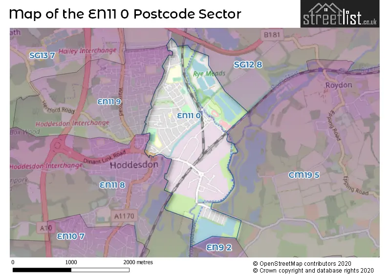
The EN11 0 Postcode shares a border with CM19 5 (HARLOW, Roydon, Roydon Mill), EN9 2 (WALTHAM ABBEY , NAZEING ), SG12 8 (Stanstead Abbotts, Hunsdon, Widford), EN11 8 (HODDESDON) and EN11 9 (HODDESDON).
The sector is within the post town of HODDESDON.
EN11 0 is a postcode sector within the EN11 postcode district which is within the EN Enfield postcode area.
The Royal Mail delivery office for the EN11 0 postal sector is the Hoddesdon Delivery Office.
The area of the EN11 0 postcode sector is 1.41 square miles which is 3.66 square kilometres or 905.45 square acres.
Waterways within the EN11 0 postcode sector include the River Lee Navigation, New River, Feilde's Weir Lock, Feilde's Weir, Dobb's Weir Lock.

Map of the EN11 0 Postcode Sector
Explore the EN11 0 postcode sector by using our free interactive map.
| E | N | 1 | 1 | - | 0 | X | X |
| E | N | 1 | 1 | Space | 0 | Letter | Letter |
Official List of Streets
HODDESDON (71 Streets)
Unofficial Streets or Alternative Spellings
HODDESDON
KENNING ROAD MIDDLEFIELD ROAD NURSERY ROAD STANSTEAD DRIVE BRIDLE WAY (NORTH) BRIDLE WAY (SOUTH) CHARLTON MEAD LANE SOUTH DINANT LINK ROAD ESSEX WALK GEDDINGS COURT KINGFISHER TRAIL MAPLE PARK MARSH COURT MOORHEN TRAIL NEW RIVER PATH NORMANDY WAY OTTER TRAIL RYE HOUSE KART CIRCUIT RYE HOUSE ROCKETS SPEEDWAY TRACK SEASONAL PATH SOUTH CHARLTON MEAD LANE ST MARGARETS ROAD ST MARTIN ROAD WOODMILL MEWSNazeing
MEADGATE ROADStanstead Abbotts
RYE ROADWeather Forecast for EN11 0
Press Button to Show Forecast for Hoddesdon
| Time Period | Icon | Description | Temperature | Rain Probability | Wind |
|---|---|---|---|---|---|
| 21:00 to 00:00 | Cloudy | 6.0°C (feels like 4.0°C) | 4.00% | NNW 7 mph |
Press Button to Show Forecast for Hoddesdon
| Time Period | Icon | Description | Temperature | Rain Probability | Wind |
|---|---|---|---|---|---|
| 00:00 to 03:00 | Cloudy | 5.0°C (feels like 2.0°C) | 3.00% | NNW 7 mph | |
| 03:00 to 06:00 | Partly cloudy (night) | 4.0°C (feels like 1.0°C) | 0.00% | NNW 9 mph | |
| 06:00 to 09:00 | Partly cloudy (day) | 4.0°C (feels like 1.0°C) | 2.00% | NNW 9 mph | |
| 09:00 to 12:00 | Cloudy | 8.0°C (feels like 4.0°C) | 4.00% | NNW 13 mph | |
| 12:00 to 15:00 | Overcast | 9.0°C (feels like 7.0°C) | 8.00% | N 11 mph | |
| 15:00 to 18:00 | Cloudy | 10.0°C (feels like 7.0°C) | 5.00% | N 11 mph | |
| 18:00 to 21:00 | Cloudy | 9.0°C (feels like 7.0°C) | 6.00% | N 9 mph | |
| 21:00 to 00:00 | Partly cloudy (night) | 5.0°C (feels like 4.0°C) | 1.00% | ENE 4 mph |
Press Button to Show Forecast for Hoddesdon
| Time Period | Icon | Description | Temperature | Rain Probability | Wind |
|---|---|---|---|---|---|
| 00:00 to 03:00 | Cloudy | 4.0°C (feels like 3.0°C) | 4.00% | SW 4 mph | |
| 03:00 to 06:00 | Cloudy | 4.0°C (feels like 2.0°C) | 4.00% | WSW 7 mph | |
| 06:00 to 09:00 | Cloudy | 5.0°C (feels like 2.0°C) | 4.00% | W 7 mph | |
| 09:00 to 12:00 | Cloudy | 8.0°C (feels like 5.0°C) | 8.00% | W 9 mph | |
| 12:00 to 15:00 | Overcast | 10.0°C (feels like 8.0°C) | 16.00% | WNW 9 mph | |
| 15:00 to 18:00 | Overcast | 10.0°C (feels like 9.0°C) | 17.00% | WNW 9 mph | |
| 18:00 to 21:00 | Partly cloudy (day) | 9.0°C (feels like 8.0°C) | 10.00% | NW 7 mph | |
| 21:00 to 00:00 | Cloudy | 6.0°C (feels like 5.0°C) | 4.00% | E 4 mph |
Press Button to Show Forecast for Hoddesdon
| Time Period | Icon | Description | Temperature | Rain Probability | Wind |
|---|---|---|---|---|---|
| 00:00 to 03:00 | Partly cloudy (night) | 5.0°C (feels like 3.0°C) | 3.00% | NNE 4 mph | |
| 03:00 to 06:00 | Cloudy | 4.0°C (feels like 2.0°C) | 5.00% | NE 4 mph | |
| 06:00 to 09:00 | Cloudy | 4.0°C (feels like 2.0°C) | 7.00% | NE 4 mph | |
| 09:00 to 12:00 | Cloudy | 8.0°C (feels like 6.0°C) | 9.00% | ENE 7 mph | |
| 12:00 to 15:00 | Overcast | 10.0°C (feels like 9.0°C) | 14.00% | ESE 7 mph | |
| 15:00 to 18:00 | Overcast | 11.0°C (feels like 9.0°C) | 19.00% | ESE 9 mph | |
| 18:00 to 21:00 | Cloudy | 10.0°C (feels like 8.0°C) | 14.00% | ESE 9 mph | |
| 21:00 to 00:00 | Cloudy | 8.0°C (feels like 5.0°C) | 15.00% | ESE 9 mph |
Press Button to Show Forecast for Hoddesdon
| Time Period | Icon | Description | Temperature | Rain Probability | Wind |
|---|---|---|---|---|---|
| 00:00 to 03:00 | Cloudy | 7.0°C (feels like 5.0°C) | 18.00% | ESE 7 mph | |
| 03:00 to 06:00 | Cloudy | 7.0°C (feels like 5.0°C) | 21.00% | E 7 mph | |
| 06:00 to 09:00 | Cloudy | 7.0°C (feels like 5.0°C) | 19.00% | E 7 mph | |
| 09:00 to 12:00 | Overcast | 10.0°C (feels like 8.0°C) | 19.00% | ESE 9 mph | |
| 12:00 to 15:00 | Cloudy | 12.0°C (feels like 10.0°C) | 17.00% | SE 9 mph | |
| 15:00 to 18:00 | Light rain | 13.0°C (feels like 10.0°C) | 49.00% | SE 9 mph | |
| 18:00 to 21:00 | Cloudy | 12.0°C (feels like 10.0°C) | 15.00% | E 9 mph | |
| 21:00 to 00:00 | Cloudy | 10.0°C (feels like 8.0°C) | 15.00% | ESE 9 mph |
Schools and Places of Education Within the EN11 0 Postcode Sector
Forres Primary School
Community school
Stanstead Road, Hoddesdon, Hertfordshire, EN11 0RW
Head: Mr Gavin Douglas
Ofsted Rating: Requires improvement
Inspection: 2022-10-05 (566 days ago)
Website: Visit Forres Primary School Website
Phone: 01992467821
Number of Pupils: 307
Rivers Education Support Centre
Pupil referral unit
Old Essex Road, Hoddesdon, Hertfordshire, EN11 0AA
Head: Mr Andrew Stuart
Ofsted Rating: Good
Inspection: 2023-11-01 (174 days ago)
Website: Visit Rivers Education Support Centre Website
Phone: 01992453950
Number of Pupils: 16
Rye Park Nursery School
Local authority nursery school
Walton Road, Hoddesden, Hertfordshire, EN11 0LN
Head: Mrs Debbie Penwill
Ofsted Rating: Outstanding
Inspection: 2023-02-22 (426 days ago)
Website: Visit Rye Park Nursery School Website
Phone: 01992462820
Number of Pupils: 138
House Prices in the EN11 0 Postcode Sector
| Type of Property | 2018 Average | 2018 Sales | 2017 Average | 2017 Sales | 2016 Average | 2016 Sales | 2015 Average | 2015 Sales |
|---|---|---|---|---|---|---|---|---|
| Detached | £521,429 | 7 | £513,929 | 14 | £521,106 | 9 | £471,950 | 10 |
| Semi-Detached | £403,644 | 17 | £371,333 | 24 | £360,746 | 26 | £330,621 | 36 |
| Terraced | £354,690 | 29 | £341,225 | 38 | £315,544 | 40 | £281,650 | 43 |
| Flats | £202,750 | 21 | £206,689 | 18 | £198,916 | 25 | £161,130 | 27 |
Important Postcodes EN11 0 in the Postcode Sector
EN11 0AA is the postcode for Rivers Education Support Centre, Old Essex Road
EN11 0BZ is the postcode for Hertfordshire County Council, Geddings Adult Training Centre, Pindar Road
EN11 0LN is the postcode for Rye Park Nursery School Centre, Walton Road
EN11 0QF is the postcode for NORTH BLOCK, The John Warner School, Stanstead Road, MATHS BUILDING, The John Warner School, Stanstead Road, The John Warner School, Stanstead Road, DESIGN AND ENGINEERING CENTRE, The John Warner School, Stanstead Road, MODERN FOREIGN LANGUAGES AND ART CENTRE, The John Warner School, Stanstead Road, 6TH FORM CENTRE, The John Warner School, Stanstead Road, MAIN BUILDING, The John Warner School, Stanstead Road, HUMANITIES, The John Warner School, Stanstead Road, ENGLISH, The John Warner School, Stanstead Road, MATHS AND LIBRARY, The John Warner School, Stanstead Road, and SCIENCE CENTRE, The John Warner School, Stanstead Road
EN11 0RH is the postcode for John Warner Sports Centre, Stanstead Road
EN11 0RW is the postcode for Forres Primary School, Stanstead Road
| The EN11 0 Sector is within these Local Authorities |
|
|---|---|
| The EN11 0 Sector is within these Counties |
|
| The EN11 0 Sector is within these Water Company Areas |
|
Tourist Attractions within the EN11 0 Postcode Area
We found 1 visitor attractions within the EN11 postcode area
| Brighwater Gardens |
|---|
| Gardens |
| Garden |
| View Brighwater Gardens on Google Maps |