The EN4 postcode district is a postal district located in the EN Enfield postcode area with a population of 27,679 residents according to the 2021 England and Wales Census.
The area of the EN4 postcode district is 5.23 square miles which is 13.56 square kilometres or 3,350.38 acres.
Currently, the EN4 district has about 551 postcode units spread across 3 geographic postcode sectors.
Given that each sector allows for 400 unique postcode combinations, the district has a capacity of 1,200 postcodes. With 551 postcodes already in use, this leaves 649 units available.
The largest settlement in the EN4 postal code is EAST BARNET followed by NEW BARNET, and ENFIELD.
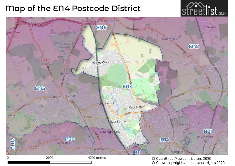
The EN4 Postcode shares a border with EN5 (BARNET, NEW BARNET), EN6 (POTTERS BAR, CUFFLEY), N14 (SOUTHGATE, NEW SOUTHGATE) and N20 (WHETSTONE).
The primary settlement in the EN4 postcode district is Barnet, located in Greater London, with a count of 125. Other significant settlements in the district include Cockfosters, East Barnet, and New Barnet. The most significant post town in the district is Barnet, also located in Greater London.
For the district EN4, we have data on 3 postcode sectors. Here's a breakdown: The sector EN4 0, covers Barnet and Cockfosters in Greater London. The sector EN4 8, covers Barnet and East Barnet in Greater London. The sector EN4 9, covers Barnet and Cockfosters in Greater London.


Map of the EN4 Postcode District
Explore the EN4 postcode district by using our free interactive map.
When it comes to local government, postal geography often disregards political borders. However, for a breakdown in the EN4 District: the district mostly encompasses the Barnet London Boro (391 postcodes), followed by the Enfield London Boro area (168 postcodes), and finally, the Hertsmere District (B) area (3 postcodes).
Recent House Sales in EN4
| Date | Price | Address |
|---|---|---|
| 27/10/2023 | £807,000 | Alverstone Avenue, East Barnet, Barnet, EN4 8DU |
| 20/10/2023 | £118,500 | Park Road, Barnet, EN4 9TE |
| 22/09/2023 | £275,000 | Clarence Close, Barnet, EN4 8AD |
| 11/09/2023 | £150,000 | Alexander Close, Barnet, EN4 9PW |
| 01/09/2023 | £625,000 | Victoria Road, New Barnet, Barnet, EN4 9PB |
| 01/09/2023 | £260,000 | Botany Close, Barnet, EN4 9RX |
| 31/08/2023 | £560,000 | Burlington Rise, East Barnet, Barnet, EN4 8NH |
| 31/08/2023 | £830,000 | Albemarle Road, East Barnet, Barnet, EN4 8EG |
| 25/08/2023 | £560,000 | Crescent Road, Barnet, EN4 9RD |
| 22/08/2023 | £1,670,000 | Cockfosters Road, Cockfosters, Barnet, EN4 0JS |
Weather Forecast for EN4
Press Button to Show Forecast for Barnet
| Time Period | Icon | Description | Temperature | Rain Probability | Wind |
|---|---|---|---|---|---|
| 18:00 to 21:00 | Cloudy | 8.0°C (feels like 7.0°C) | 4.00% | N 7 mph | |
| 21:00 to 00:00 | Cloudy | 6.0°C (feels like 5.0°C) | 4.00% | ENE 4 mph |
Press Button to Show Forecast for Barnet
| Time Period | Icon | Description | Temperature | Rain Probability | Wind |
|---|---|---|---|---|---|
| 00:00 to 03:00 | Cloudy | 5.0°C (feels like 4.0°C) | 5.00% | SSE 4 mph | |
| 03:00 to 06:00 | Cloudy | 5.0°C (feels like 3.0°C) | 4.00% | SSW 7 mph | |
| 06:00 to 09:00 | Cloudy | 5.0°C (feels like 3.0°C) | 7.00% | SW 7 mph | |
| 09:00 to 12:00 | Cloudy | 9.0°C (feels like 6.0°C) | 7.00% | W 9 mph | |
| 12:00 to 15:00 | Overcast | 9.0°C (feels like 7.0°C) | 13.00% | W 11 mph | |
| 15:00 to 18:00 | Cloudy | 9.0°C (feels like 7.0°C) | 49.00% | NW 9 mph | |
| 18:00 to 21:00 | Cloudy | 7.0°C (feels like 5.0°C) | 44.00% | NNE 7 mph | |
| 21:00 to 00:00 | Cloudy | 6.0°C (feels like 4.0°C) | 7.00% | ENE 7 mph |
Press Button to Show Forecast for Barnet
| Time Period | Icon | Description | Temperature | Rain Probability | Wind |
|---|---|---|---|---|---|
| 00:00 to 03:00 | Cloudy | 5.0°C (feels like 3.0°C) | 4.00% | NE 7 mph | |
| 03:00 to 06:00 | Cloudy | 3.0°C (feels like 1.0°C) | 4.00% | NE 7 mph | |
| 06:00 to 09:00 | Partly cloudy (day) | 3.0°C (feels like 0.0°C) | 1.00% | NE 7 mph | |
| 09:00 to 12:00 | Partly cloudy (day) | 7.0°C (feels like 4.0°C) | 2.00% | ENE 7 mph | |
| 12:00 to 15:00 | Cloudy | 10.0°C (feels like 8.0°C) | 9.00% | ENE 7 mph | |
| 15:00 to 18:00 | Overcast | 10.0°C (feels like 9.0°C) | 14.00% | ENE 4 mph | |
| 18:00 to 21:00 | Cloudy | 9.0°C (feels like 7.0°C) | 11.00% | ENE 7 mph | |
| 21:00 to 00:00 | Cloudy | 6.0°C (feels like 4.0°C) | 11.00% | E 7 mph |
Press Button to Show Forecast for Barnet
| Time Period | Icon | Description | Temperature | Rain Probability | Wind |
|---|---|---|---|---|---|
| 00:00 to 03:00 | Cloudy | 4.0°C (feels like 2.0°C) | 12.00% | ENE 7 mph | |
| 03:00 to 06:00 | Cloudy | 4.0°C (feels like 1.0°C) | 18.00% | NE 7 mph | |
| 06:00 to 09:00 | Cloudy | 4.0°C (feels like 1.0°C) | 20.00% | NE 9 mph | |
| 09:00 to 12:00 | Overcast | 8.0°C (feels like 6.0°C) | 19.00% | ENE 9 mph | |
| 12:00 to 15:00 | Overcast | 11.0°C (feels like 8.0°C) | 20.00% | E 9 mph | |
| 15:00 to 18:00 | Cloudy | 11.0°C (feels like 9.0°C) | 21.00% | E 11 mph | |
| 18:00 to 21:00 | Cloudy | 10.0°C (feels like 8.0°C) | 23.00% | ENE 11 mph | |
| 21:00 to 00:00 | Light rain | 8.0°C (feels like 5.0°C) | 51.00% | NE 13 mph |
Press Button to Show Forecast for Barnet
| Time Period | Icon | Description | Temperature | Rain Probability | Wind |
|---|---|---|---|---|---|
| 00:00 to 03:00 | Heavy rain | 8.0°C (feels like 5.0°C) | 73.00% | NE 11 mph | |
| 03:00 to 06:00 | Light rain | 8.0°C (feels like 6.0°C) | 55.00% | E 9 mph | |
| 06:00 to 09:00 | Cloudy | 9.0°C (feels like 6.0°C) | 41.00% | SE 9 mph | |
| 09:00 to 12:00 | Light rain shower (day) | 10.0°C (feels like 8.0°C) | 46.00% | SE 9 mph | |
| 12:00 to 15:00 | Heavy rain shower (day) | 11.0°C (feels like 9.0°C) | 62.00% | S 9 mph | |
| 15:00 to 18:00 | Light rain shower (day) | 13.0°C (feels like 10.0°C) | 42.00% | SW 11 mph | |
| 18:00 to 21:00 | Cloudy | 11.0°C (feels like 9.0°C) | 17.00% | SW 11 mph | |
| 21:00 to 00:00 | Overcast | 9.0°C (feels like 7.0°C) | 11.00% | WSW 9 mph |
Where is the EN4 Postcode District?
The EN4 postcode district is located in Barnet. Barnet is situated near several towns, including Cockfosters to the south, Station Road to Brookhill Road to the southwest, and Potters Road to Hadley Common to the west. Additionally, Barnet is approximately 10.6 miles away from the center of London.
The district is within the post town of BARNET.
The sector has postcodes within the nation of England.
The EN4 Postcode District is covers the following regions.
- Enfield - Outer London - East and North East - London
- Barnet - Outer London - West and North West - London
- Hertfordshire - Bedfordshire and Hertfordshire - East of England
| Postcode Sector | Delivery Office |
|---|---|
| EN4 0 | Barnet Delivery Office |
| EN4 8 | Barnet Delivery Office |
| EN4 9 | Barnet Delivery Office |
| E | N | 4 | - | X | X | X |
| E | N | 4 | Space | Numeric | Letter | Letter |
Tourist Attractions within the Postcode Area
We found 1 visitor attractions within the EN4 postcode area
| Go Ape! Tree Top Adventure - Trent Park |
|---|
| Country Parks |
| Country Park |
| View Go Ape! Tree Top Adventure - Trent Park on Google Maps |
Current Monthly Rental Prices
| # Bedrooms | Min Price | Max Price | Avg Price |
|---|---|---|---|
| 1 | £1,200 | £2,350 | £1,544 |
| 2 | £1,500 | £6,250 | £2,742 |
| 3 | £1,650 | £8,500 | £3,745 |
| 4 | £2,750 | £5,250 | £3,857 |
| 5 | £2,500 | £9,950 | £5,150 |
| 6 | £4,000 | £22,000 | £8,785 |
Current House Prices
| # Bedrooms | Min Price | Max Price | Avg Price |
|---|---|---|---|
| £140,000 | £4,500,000 | £973,111 | |
| 1 | £110,625 | £575,000 | £312,945 |
| 2 | £130,000 | £1,250,000 | £535,867 |
| 3 | £330,000 | £1,695,000 | £779,937 |
| 4 | £575,000 | £2,415,000 | £984,164 |
| 5 | £750,000 | £3,105,000 | £1,843,947 |
| 6 | £1,800,000 | £4,750,000 | £2,913,214 |
| 7 | £4,350,000 | £6,500,000 | £5,425,000 |
| 8 | £5,000,000 | £5,000,000 | £5,000,000 |
Estate Agents who Operate in the EN4 District
| Logo | Name | Brand Name | Address | Contact Number | Total Properties |
|---|---|---|---|---|---|
 | Hadley Wood | Statons | 10 Crescent West, Barnet, EN4 0EJ | 020 3834 8015 | 44 |
 | East Barnet | Aleco Estate Agents | 256 East Barnet Road, East Barnet, Barnet, EN4 8TD | 020 3834 8140 | 17 |
 | East Barnet | Chas R Lowe Estates | 10 Church Hill Road, Barnet, EN4 8TB | 020 3834 8577 | 16 |
 | Cockfosters | Michael Wright & Co | 125 Cockfosters Road Cockfosters Barnet EN4 0DA | 020 3873 7675 | 13 |
 | Barnet - Lettings | Statons | 1-2 Hadley Parade, High Street, Barnet, EN5 5SX | 020 3909 6576 | 11 |
| Type of Property | 2018 Average | 2018 Sales | 2017 Average | 2017 Sales | 2016 Average | 2016 Sales | 2015 Average | 2015 Sales |
|---|---|---|---|---|---|---|---|---|
| Detached | £1,475,279 | 43 | £1,425,121 | 36 | £1,438,137 | 53 | £1,037,472 | 47 |
| Semi-Detached | £672,734 | 88 | £658,809 | 111 | £636,484 | 116 | £580,628 | 135 |
| Terraced | £555,813 | 51 | £594,694 | 88 | £587,694 | 86 | £471,564 | 73 |
| Flats | £378,904 | 107 | £438,742 | 212 | £425,459 | 190 | £360,507 | 130 |