The EN5 2 postcode sector is within the county of Greater London.
Did you know? According to the 2021 Census, the EN5 2 postcode sector is home to a bustling 13,312 residents!
Given that each sector allows for 400 unique postcode combinations. Letters C, I, K, M, O and V are not allowed in the last two letters of a postcode. With 253 postcodes already in use, this leaves 147 units available.
The largest settlement in the EN5 2 postal code is BARNET followed by UNDERHILL , and CHIPPING BARNET .
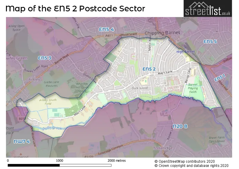
The EN5 2 Postcode shares a border with NW7 4 (MILL HILL , BARNET GATE , MARSH LANE TO TOTTERIDGE COMMON ), N20 8 (WHETSTONE , TOTTERIDGE ), EN5 1 (NEW BARNET , BARNET , UNDERHILL ), EN5 3 (BARNET , ARKLEY , UNDERHILL ), EN5 4 (BARNET , DURY ROAD TO GREAT NORTH ROAD , ARKLEY BARNET SECTION ) and EN5 5 (NEW BARNET , BARNET , POTTERS ROAD TO HADLEY COMMON ).
The sector is within the post town of BARNET.
EN5 2 is a postcode sector within the EN5 postcode district which is within the EN Enfield postcode area.
The Royal Mail delivery office for the EN5 2 postal sector is the Barnet Delivery Office.
The area of the EN5 2 postcode sector is 1.23 square miles which is 3.18 square kilometres or 786.47 square acres.
Waterways within the EN5 2 postcode sector include the Dollis Brook.

Map of the EN5 2 Postcode Sector
Explore the EN5 2 postcode sector by using our free interactive map.
| E | N | 5 | - | 2 | X | X |
| E | N | 5 | Space | 2 | Letter | Letter |
Official List of Streets
BARNET (108 Streets)
Unofficial Streets or Alternative Spellings
Weather Forecast for EN5 2
Press Button to Show Forecast for Barnet
| Time Period | Icon | Description | Temperature | Rain Probability | Wind |
|---|---|---|---|---|---|
| 21:00 to 00:00 | Cloudy | 6.0°C (feels like 4.0°C) | 7.00% | ENE 7 mph |
Press Button to Show Forecast for Barnet
| Time Period | Icon | Description | Temperature | Rain Probability | Wind |
|---|---|---|---|---|---|
| 00:00 to 03:00 | Cloudy | 5.0°C (feels like 3.0°C) | 4.00% | NE 7 mph | |
| 03:00 to 06:00 | Cloudy | 3.0°C (feels like 1.0°C) | 4.00% | NE 7 mph | |
| 06:00 to 09:00 | Partly cloudy (day) | 3.0°C (feels like 0.0°C) | 1.00% | NE 7 mph | |
| 09:00 to 12:00 | Partly cloudy (day) | 7.0°C (feels like 4.0°C) | 2.00% | ENE 7 mph | |
| 12:00 to 15:00 | Cloudy | 10.0°C (feels like 8.0°C) | 9.00% | ENE 7 mph | |
| 15:00 to 18:00 | Overcast | 10.0°C (feels like 9.0°C) | 14.00% | ENE 4 mph | |
| 18:00 to 21:00 | Cloudy | 9.0°C (feels like 7.0°C) | 11.00% | ENE 7 mph | |
| 21:00 to 00:00 | Cloudy | 6.0°C (feels like 4.0°C) | 11.00% | E 7 mph |
Press Button to Show Forecast for Barnet
| Time Period | Icon | Description | Temperature | Rain Probability | Wind |
|---|---|---|---|---|---|
| 00:00 to 03:00 | Cloudy | 4.0°C (feels like 2.0°C) | 12.00% | ENE 7 mph | |
| 03:00 to 06:00 | Cloudy | 4.0°C (feels like 1.0°C) | 18.00% | NE 7 mph | |
| 06:00 to 09:00 | Cloudy | 4.0°C (feels like 1.0°C) | 20.00% | NE 9 mph | |
| 09:00 to 12:00 | Overcast | 8.0°C (feels like 6.0°C) | 19.00% | ENE 9 mph | |
| 12:00 to 15:00 | Overcast | 11.0°C (feels like 8.0°C) | 20.00% | E 9 mph | |
| 15:00 to 18:00 | Cloudy | 11.0°C (feels like 9.0°C) | 21.00% | E 11 mph | |
| 18:00 to 21:00 | Cloudy | 10.0°C (feels like 8.0°C) | 23.00% | ENE 11 mph | |
| 21:00 to 00:00 | Light rain | 8.0°C (feels like 5.0°C) | 51.00% | NE 13 mph |
Press Button to Show Forecast for Barnet
| Time Period | Icon | Description | Temperature | Rain Probability | Wind |
|---|---|---|---|---|---|
| 00:00 to 03:00 | Heavy rain | 8.0°C (feels like 5.0°C) | 73.00% | NE 11 mph | |
| 03:00 to 06:00 | Light rain | 8.0°C (feels like 6.0°C) | 55.00% | E 9 mph | |
| 06:00 to 09:00 | Cloudy | 9.0°C (feels like 6.0°C) | 41.00% | SE 9 mph | |
| 09:00 to 12:00 | Light rain shower (day) | 10.0°C (feels like 8.0°C) | 46.00% | SE 9 mph | |
| 12:00 to 15:00 | Heavy rain shower (day) | 11.0°C (feels like 9.0°C) | 62.00% | S 9 mph | |
| 15:00 to 18:00 | Light rain shower (day) | 13.0°C (feels like 10.0°C) | 42.00% | SW 11 mph | |
| 18:00 to 21:00 | Cloudy | 11.0°C (feels like 9.0°C) | 17.00% | SW 11 mph | |
| 21:00 to 00:00 | Overcast | 9.0°C (feels like 7.0°C) | 11.00% | WSW 9 mph |
Schools and Places of Education Within the EN5 2 Postcode Sector
Ark Pioneer Academy
Free schools
Westcombe Drive, Barnet, , EN5 2BE
Head: Ms Aishling Ryan
Ofsted Rating: Outstanding
Inspection: 2023-09-14 (224 days ago)
Website: Visit Ark Pioneer Academy Website
Phone: 02037874090
Number of Pupils: 720
St Catherine's RC School
Voluntary aided school
Vale Drive, Barnet, Hertfordshire, EN5 2ED
Head: Miss Maureen Kelly
Ofsted Rating: Good
Inspection: 2022-06-23 (672 days ago)
Website: Visit St Catherine's RC School Website
Phone: 02084404946
Number of Pupils: 473
Underhill School
Community school
Mays Lane, Barnet, Hertfordshire, EN5 2LZ
Head: Ms Jennie Reed and Nicola Hayles
Ofsted Rating: Good
Inspection: 2023-02-09 (441 days ago)
Website: Visit Underhill School Website
Phone: 02084492423
Number of Pupils: 539
Whitings Hill Primary School
Community school
Whitings Road, Barnet, Hertfordshire, EN5 2QY
Head: Mrs Deepa Samani
Ofsted Rating: Outstanding
Inspection: 2023-12-14 (133 days ago)
Website: Visit Whitings Hill Primary School Website
Phone: 02083595360
Number of Pupils: 459
House Prices in the EN5 2 Postcode Sector
| Type of Property | 2018 Average | 2018 Sales | 2017 Average | 2017 Sales | 2016 Average | 2016 Sales | 2015 Average | 2015 Sales |
|---|---|---|---|---|---|---|---|---|
| Detached | £713,188 | 16 | £855,000 | 5 | £794,792 | 24 | £734,800 | 25 |
| Semi-Detached | £672,138 | 48 | £578,205 | 39 | £618,234 | 66 | £537,104 | 55 |
| Terraced | £533,544 | 55 | £496,538 | 39 | £494,282 | 50 | £469,948 | 93 |
| Flats | £400,618 | 35 | £315,521 | 73 | £312,338 | 40 | £276,293 | 53 |
Important Postcodes EN5 2 in the Postcode Sector
EN5 2BE is the postcode for Ark Pioneer Academy, Westcombe Drive, Underhill, and Ark Pioneer Academy, Westcombe Drive
EN5 2BY is the postcode for Grasvenor Avenue Infant School, Grasvenor Avenue
EN5 2ED is the postcode for St. Catherine's Catholic Primary School, Vale Drive, Barnet PCT, Vale Drive Primary Care Centre, VALE DRIVE PRIMARY CARE CENTRE, VALE DRIVE, and St. Catherines RC Primary School, Vale Drive
EN5 2HE is the postcode for GF Office Space, Graseby House, 5 Fitzjohn Ave
EN5 2LZ is the postcode for INFANT SCHOOL, Underhill Junior & Infant School, Mays Lane, JUNIOR SCHOOL, Underhill Junior & Infant School, Mays Lane, KS2 BUILDING, Underhill School & Childrens Centre, Mays Lane, and KITCHEN & DINING HALL, Underhill School & Childrens Centre, Mays Lane
EN5 2QY is the postcode for Whitings Hill School, Whitings Road
| The EN5 2 Sector is within these Local Authorities |
|
|---|---|
| The EN5 2 Sector is within these Counties |
|
| The EN5 2 Sector is within these Water Company Areas |
|