The EX37 postcode district is a postal district located in the EX Exeter postcode area with a population of 3,783 residents according to the 2021 England and Wales Census.
The area of the EX37 postcode district is 49.17 square miles which is 127.35 square kilometres or 31,470.07 acres.
Currently, the EX37 district has about 199 postcode units spread across 1 geographic postcode sectors.
Given that each sector allows for 400 unique postcode combinations, the district has a capacity of 400 postcodes. With 199 postcodes already in use, this leaves 201 units available.
The largest settlement in the EX37 postal code is High Bickington followed by Chittlehampton, and Burrington.
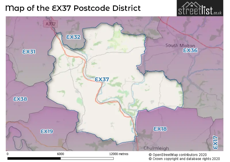
The EX37 Postcode shares a border with EX18 (CHULMLEIGH, Chawleigh, Wembworthy), EX19 (WINKLEIGH, Dolton, Beaford), EX32 (BARNSTAPLE, Landkey, Bishops Tawton), EX36 (SOUTH MOLTON, North Molton, Bishops Nympton), EX38 (TORRINGTON, Langtree, St. Giles) and EX31 (BARNSTAPLE, Roundswell, Fremington).
The primary settlement in the EX37 postcode district is Umberleigh, located in the county of Devon, England. Other significant settlements in the district include Atherington, Burrington, Chittlehamholt, Chittlehampton, High Bickington, Kings Nympton, Satterleigh, and Warkleigh. The post town for this postcode district is Umberleigh.
For the district EX37, we have data on 1 postcode sectors. Here's a breakdown: The sector EX37 9, covers Chittlehampton and Burrington and High Bickington and Umberleigh in Devon.
EX37 Postcode Sectors

Map of the EX37 Postcode District
Explore the EX37 postcode district by using our free interactive map.
When it comes to local government, postal geography often disregards political borders. However, for a breakdown in the EX37 District: the district mostly encompasses the North Devon District (163 postcodes), and finally, the Torridge District area (38 postcodes).
Recent House Sales in EX37
| Date | Price | Address |
|---|---|---|
| 03/10/2023 | £261,000 | Mayflower Close, Chittlehampton, Umberleigh, EX37 9QD |
| 03/10/2023 | £280,000 | Nymet Villas, Kings Nympton, Umberleigh, EX37 9SR |
| 01/09/2023 | £299,000 | The Square, Chittlehampton, Umberleigh, EX37 9QW |
| 22/08/2023 | £659,100 | Umberleigh, EX37 9AL |
| 16/08/2023 | £188,000 | Townsend Cottages, Chittlehampton, Umberleigh, EX37 9PU |
| 04/08/2023 | £165,000 | High Bickington, Umberleigh, EX37 9BN |
| 28/07/2023 | £385,000 | Bradbury Cottages, Chittlehampton, Umberleigh, EX37 9RE |
| 27/07/2023 | £240,000 | Kings Nympton, Umberleigh, EX37 9SS |
| 19/07/2023 | £395,000 | North Road, High Bickington, Umberleigh, EX37 9BB |
| 19/07/2023 | £750,000 | Atherington, Umberleigh, EX37 9HN |
Weather Forecast for EX37
Press Button to Show Forecast for Warkleigh
| Time Period | Icon | Description | Temperature | Rain Probability | Wind |
|---|---|---|---|---|---|
| 12:00 to 15:00 | Overcast | 10.0°C (feels like 7.0°C) | 13.00% | NW 16 mph | |
| 15:00 to 18:00 | Cloudy | 12.0°C (feels like 9.0°C) | 13.00% | NNW 16 mph | |
| 18:00 to 21:00 | Sunny day | 11.0°C (feels like 8.0°C) | 2.00% | NNW 11 mph | |
| 21:00 to 00:00 | Clear night | 7.0°C (feels like 4.0°C) | 0.00% | NNW 7 mph |
Press Button to Show Forecast for Warkleigh
| Time Period | Icon | Description | Temperature | Rain Probability | Wind |
|---|---|---|---|---|---|
| 00:00 to 03:00 | Clear night | 4.0°C (feels like 2.0°C) | 0.00% | NE 4 mph | |
| 03:00 to 06:00 | Clear night | 2.0°C (feels like 0.0°C) | 0.00% | ENE 4 mph | |
| 06:00 to 09:00 | Sunny day | 3.0°C (feels like 2.0°C) | 0.00% | ESE 4 mph | |
| 09:00 to 12:00 | Sunny day | 9.0°C (feels like 8.0°C) | 0.00% | SE 4 mph | |
| 12:00 to 15:00 | Cloudy | 11.0°C (feels like 10.0°C) | 5.00% | N 4 mph | |
| 15:00 to 18:00 | Partly cloudy (day) | 12.0°C (feels like 11.0°C) | 1.00% | NNW 7 mph | |
| 18:00 to 21:00 | Sunny day | 10.0°C (feels like 9.0°C) | 1.00% | NW 7 mph | |
| 21:00 to 00:00 | Clear night | 5.0°C (feels like 4.0°C) | 0.00% | NNW 2 mph |
Press Button to Show Forecast for Warkleigh
| Time Period | Icon | Description | Temperature | Rain Probability | Wind |
|---|---|---|---|---|---|
| 00:00 to 03:00 | Partly cloudy (night) | 4.0°C (feels like 3.0°C) | 1.00% | S 2 mph | |
| 03:00 to 06:00 | Clear night | 3.0°C (feels like 2.0°C) | 0.00% | E 4 mph | |
| 06:00 to 09:00 | Sunny day | 4.0°C (feels like 3.0°C) | 1.00% | E 4 mph | |
| 09:00 to 12:00 | Sunny day | 10.0°C (feels like 9.0°C) | 0.00% | NE 4 mph | |
| 12:00 to 15:00 | Partly cloudy (day) | 12.0°C (feels like 11.0°C) | 0.00% | NNE 9 mph | |
| 15:00 to 18:00 | Partly cloudy (day) | 12.0°C (feels like 10.0°C) | 1.00% | N 9 mph | |
| 18:00 to 21:00 | Partly cloudy (day) | 11.0°C (feels like 9.0°C) | 1.00% | NNE 7 mph | |
| 21:00 to 00:00 | Partly cloudy (night) | 7.0°C (feels like 6.0°C) | 1.00% | NE 4 mph |
Press Button to Show Forecast for Warkleigh
| Time Period | Icon | Description | Temperature | Rain Probability | Wind |
|---|---|---|---|---|---|
| 00:00 to 03:00 | Partly cloudy (night) | 6.0°C (feels like 4.0°C) | 1.00% | NE 4 mph | |
| 03:00 to 06:00 | Partly cloudy (night) | 4.0°C (feels like 2.0°C) | 1.00% | ENE 4 mph | |
| 06:00 to 09:00 | Partly cloudy (day) | 5.0°C (feels like 3.0°C) | 1.00% | ENE 4 mph | |
| 09:00 to 12:00 | Cloudy | 9.0°C (feels like 8.0°C) | 5.00% | NE 4 mph | |
| 12:00 to 15:00 | Overcast | 11.0°C (feels like 10.0°C) | 9.00% | N 7 mph | |
| 15:00 to 18:00 | Cloudy | 11.0°C (feels like 9.0°C) | 10.00% | NNW 9 mph | |
| 18:00 to 21:00 | Cloudy | 10.0°C (feels like 8.0°C) | 12.00% | NNW 9 mph | |
| 21:00 to 00:00 | Partly cloudy (night) | 8.0°C (feels like 6.0°C) | 5.00% | N 7 mph |
Press Button to Show Forecast for Warkleigh
| Time Period | Icon | Description | Temperature | Rain Probability | Wind |
|---|---|---|---|---|---|
| 00:00 to 03:00 | Cloudy | 7.0°C (feels like 5.0°C) | 9.00% | NNE 7 mph | |
| 03:00 to 06:00 | Partly cloudy (night) | 6.0°C (feels like 4.0°C) | 3.00% | NNE 4 mph | |
| 06:00 to 09:00 | Partly cloudy (day) | 6.0°C (feels like 5.0°C) | 5.00% | NNE 4 mph | |
| 09:00 to 12:00 | Cloudy | 10.0°C (feels like 8.0°C) | 6.00% | NNE 7 mph | |
| 12:00 to 15:00 | Cloudy | 12.0°C (feels like 10.0°C) | 8.00% | NNE 11 mph | |
| 15:00 to 18:00 | Cloudy | 12.0°C (feels like 9.0°C) | 11.00% | NNE 11 mph | |
| 18:00 to 21:00 | Partly cloudy (day) | 11.0°C (feels like 9.0°C) | 2.00% | NNE 9 mph | |
| 21:00 to 00:00 | Clear night | 8.0°C (feels like 6.0°C) | 2.00% | NNE 7 mph |
Where is the EX37 Postcode District?
The postcode district for UMBERLEIGH, with the postcode EX37, is located in North Devon. It is surrounded by several nearby towns: CHULMLEIGH to the South East, SOUTH MOLTON to the North East, WINKLEIGH to the South, TORRINGTON to the West, and BARNSTAPLE to the North West. Furthermore, UMBERLEIGH is approximately 169.65 miles away from the center of London.
The district is within the post town of UMBERLEIGH.
The sector has postcodes within the nation of England.
The EX37 Postcode District is in the Devon CC region of Devon within the South West (England).
Postcode Sectors within the EX37 District
| Postcode Sector | Delivery Office |
|---|---|
| EX37 9 | Umberleigh Scale Payment Delivery Office |
| EX37 9 | Chittlehampton Scale Payment Delivery Office |
| E | X | 3 | 7 | - | X | X | X |
| E | X | 3 | 7 | Space | Numeric | Letter | Letter |
Current Monthly Rental Prices
| # Bedrooms | Min Price | Max Price | Avg Price |
|---|---|---|---|
| 1 | £680 | £680 | £680 |
| 3 | £1,095 | £1,095 | £1,095 |
Current House Prices
| # Bedrooms | Min Price | Max Price | Avg Price |
|---|---|---|---|
| £15,000 | £500,000 | £179,444 | |
| 2 | £105,000 | £159,950 | £140,817 |
| 3 | £234,500 | £700,000 | £455,864 |
| 4 | £225,000 | £1,250,000 | £597,768 |
| 5 | £280,000 | £2,750,000 | £916,000 |
| 6 | £700,000 | £760,000 | £730,000 |
| 7 | £1,250,000 | £1,250,000 | £1,250,000 |
Estate Agents who Operate in the EX37 District
| Logo | Name | Brand Name | Address | Contact Number | Total Properties |
|---|---|---|---|---|---|
 | Barnstaple | Stags | 30 Boutport Street, Barnstaple, EX31 1RP | 01271 444035 | 6 |
 | South Molton | Greenslade Taylor Hunt | 23 Broad Street, South Molton, EX36 3AQ | 01769 612727 | 6 |
 | Barnstaple | John Smale & Co | 5 Cross Street, Barnstaple, EX31 1BA | 01271 443504 | 5 |
 | Barnstaple | Bond Oxborough Phillips | 105-106 Boutport Street, Barnstaple, EX31 1SY | 01271 371234 | 4 |
 | South Molton | Michael Adey Property | 106 East Street, South Molton, EX36 3DB | 01769 612732 | 4 |
| Type of Property | 2018 Average | 2018 Sales | 2017 Average | 2017 Sales | 2016 Average | 2016 Sales | 2015 Average | 2015 Sales |
|---|---|---|---|---|---|---|---|---|
| Detached | £367,572 | 36 | £370,483 | 38 | £476,555 | 33 | £319,259 | 29 |
| Semi-Detached | £225,100 | 10 | £217,814 | 14 | £195,219 | 8 | £208,014 | 13 |
| Terraced | £210,288 | 12 | £203,350 | 10 | £260,690 | 10 | £168,163 | 12 |
| Flats | £93,750 | 1 | £0 | 0 | £0 | 0 | £0 | 0 |
Hotels within the Postcode Area
We found 19 hotels and guest houses within the EX37 postcode area
Prospect Cottage
The Square Prospect Cottage, Chittlehampton, chittlehampton, EX37 9QW.
View detailsHighbullen Hotel, Golf and Country Club
Chittlehamholt, Umberleigh, umberleigh-bridge, EX37 9HD.
View detailsSampson Barton Guest House
Sampson Barton, Kings Nympton, Umberleigh, Devon, South Molton, south-molton, EX37 9TG.
View details