The EX5 2 postcode sector is within the county of Devon.
Did you know? According to the 2021 Census, the EX5 2 postcode sector is home to a bustling 4,881 residents!
Given that each sector allows for 400 unique postcode combinations. Letters C, I, K, M, O and V are not allowed in the last two letters of a postcode. With 271 postcodes already in use, this leaves 129 units available.
The largest settlement in the EX5 2 postal code is Whimple followed by Clyst Honiton, and Aylesbeare.
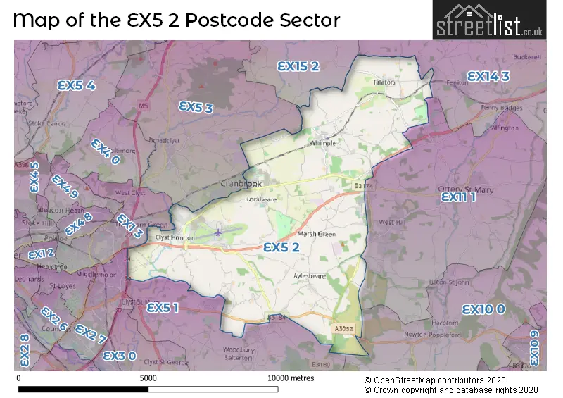
The EX5 2 Postcode shares a border with EX1 3 (EXETER, Tithebarn, Exeter Business Park), EX10 0 (Newton Poppleford, Sidbury, Colaton Raleigh), EX11 1 (OTTERY ST. MARY, West Hill, Alfington), EX15 2 (Willand, Kentisbeare, Blackborough), EX2 7 (EXETER, Sowton Industrial Estate, Newport Park), EX5 1 (Woodbury, Clyst St. Mary, Woodbury Salterton), EX5 3 (Broadclyst, Budlake, Broadclyst Station) and EX14 3 (Feniton, Payhembury, Gittisham).
The sector is within the post town of EXETER.
EX5 2 is a postcode sector within the EX5 postcode district which is within the EX Exeter postcode area.
The Royal Mail delivery office for the EX5 2 postal sector is the Clyst Honiton Scale Payment Delivery Office and Whimple Scale Payment Delivery Office.
The area of the EX5 2 postcode sector is 24.18 square miles which is 62.64 square kilometres or 15,478.03 square acres.
The EX5 2 postcode sector is crossed by the M5 motorway.
The EX5 2 postcode sector is crossed by the A30 Major A road.
Waterways within the EX5 2 postcode sector include the River Clyst.

Map of the EX5 2 Postcode Sector
Explore the EX5 2 postcode sector by using our free interactive map.
| E | X | 5 | - | 2 | X | X |
| E | X | 5 | Space | 2 | Letter | Letter |
Official List of Streets
Whimple (36 Streets)
Clyst Honiton (20 Streets)
Talaton (5 Streets)
Rockbeare (16 Streets)
Blackhorse (2 Streets)
Aylesbeare (14 Streets)
Farringdon (4 Streets)
Marsh Green (1 Streets)
Sowton (1 Streets)
Unofficial Streets or Alternative Spellings
West Hill
BENDARROCH ROAD BRICKYARD ROADBroadclyst
STATION ROADTithebarn
GARLAND MEADOW HUTCHINGS DRIVE LITTLEWORTH CLOSE TITHEBARN WAY TURNER CLOSEEXETER
HONITON ROADWeather Forecast for EX5 2
Press Button to Show Forecast for Exeter Airport
| Time Period | Icon | Description | Temperature | Rain Probability | Wind |
|---|---|---|---|---|---|
| 00:00 to 03:00 | Partly cloudy (night) | 6.0°C (feels like 5.0°C) | 0.00% | WNW 4 mph | |
| 03:00 to 06:00 | Partly cloudy (night) | 4.0°C (feels like 2.0°C) | 1.00% | NNW 2 mph | |
| 06:00 to 09:00 | Cloudy | 5.0°C (feels like 4.0°C) | 4.00% | NW 2 mph | |
| 09:00 to 12:00 | Cloudy | 10.0°C (feels like 9.0°C) | 9.00% | WSW 4 mph | |
| 12:00 to 15:00 | Heavy rain | 11.0°C (feels like 9.0°C) | 77.00% | WNW 9 mph | |
| 15:00 to 18:00 | Cloudy | 13.0°C (feels like 11.0°C) | 5.00% | WNW 13 mph | |
| 18:00 to 21:00 | Cloudy | 11.0°C (feels like 9.0°C) | 4.00% | NW 9 mph | |
| 21:00 to 00:00 | Cloudy | 7.0°C (feels like 5.0°C) | 4.00% | NW 7 mph |
Press Button to Show Forecast for Exeter Airport
| Time Period | Icon | Description | Temperature | Rain Probability | Wind |
|---|---|---|---|---|---|
| 00:00 to 03:00 | Cloudy | 5.0°C (feels like 3.0°C) | 3.00% | NW 4 mph | |
| 03:00 to 06:00 | Cloudy | 4.0°C (feels like 3.0°C) | 4.00% | NNW 2 mph | |
| 06:00 to 09:00 | Cloudy | 5.0°C (feels like 4.0°C) | 7.00% | N 2 mph | |
| 09:00 to 12:00 | Cloudy | 9.0°C (feels like 7.0°C) | 14.00% | ENE 7 mph | |
| 12:00 to 15:00 | Overcast | 11.0°C (feels like 9.0°C) | 22.00% | ESE 9 mph | |
| 15:00 to 18:00 | Cloudy | 10.0°C (feels like 9.0°C) | 22.00% | SE 9 mph | |
| 18:00 to 21:00 | Light rain | 10.0°C (feels like 8.0°C) | 47.00% | E 7 mph | |
| 21:00 to 00:00 | Cloudy | 8.0°C (feels like 6.0°C) | 11.00% | ENE 4 mph |
Press Button to Show Forecast for Exeter Airport
| Time Period | Icon | Description | Temperature | Rain Probability | Wind |
|---|---|---|---|---|---|
| 00:00 to 03:00 | Overcast | 7.0°C (feels like 5.0°C) | 22.00% | NE 4 mph | |
| 03:00 to 06:00 | Heavy rain | 6.0°C (feels like 3.0°C) | 72.00% | NE 4 mph | |
| 06:00 to 09:00 | Light rain | 6.0°C (feels like 3.0°C) | 52.00% | NE 7 mph | |
| 09:00 to 12:00 | Overcast | 8.0°C (feels like 5.0°C) | 19.00% | NE 9 mph | |
| 12:00 to 15:00 | Cloudy | 11.0°C (feels like 9.0°C) | 16.00% | ENE 11 mph | |
| 15:00 to 18:00 | Light rain | 12.0°C (feels like 9.0°C) | 51.00% | ENE 13 mph | |
| 18:00 to 21:00 | Overcast | 11.0°C (feels like 9.0°C) | 21.00% | NE 11 mph | |
| 21:00 to 00:00 | Light rain | 9.0°C (feels like 6.0°C) | 49.00% | NNE 9 mph |
Press Button to Show Forecast for Exeter Airport
| Time Period | Icon | Description | Temperature | Rain Probability | Wind |
|---|---|---|---|---|---|
| 00:00 to 03:00 | Light rain | 8.0°C (feels like 4.0°C) | 52.00% | NNE 11 mph | |
| 03:00 to 06:00 | Light rain | 7.0°C (feels like 3.0°C) | 57.00% | N 9 mph | |
| 06:00 to 09:00 | Light rain | 7.0°C (feels like 4.0°C) | 53.00% | NNW 9 mph | |
| 09:00 to 12:00 | Light rain | 9.0°C (feels like 5.0°C) | 51.00% | NNW 11 mph | |
| 12:00 to 15:00 | Light rain | 11.0°C (feels like 8.0°C) | 50.00% | NW 13 mph | |
| 15:00 to 18:00 | Cloudy | 12.0°C (feels like 10.0°C) | 17.00% | NW 13 mph | |
| 18:00 to 21:00 | Cloudy | 12.0°C (feels like 10.0°C) | 11.00% | NW 9 mph | |
| 21:00 to 00:00 | Partly cloudy (night) | 8.0°C (feels like 6.0°C) | 4.00% | WNW 4 mph |
Schools and Places of Education Within the EX5 2 Postcode Sector
Rockbeare Church of England Primary School and Pre-School
Academy converter
Rockbeare, Exeter, Devon, EX5 2EQ
Head: Mrs Sally Davies
Ofsted Rating: Good
Inspection: 2022-04-27 (729 days ago)
Website: Visit Rockbeare Church of England Primary School and Pre-School Website
Phone: 01404822501
Number of Pupils: 105
The Wildings
Other independent special school
Royston Farm, , , EX5 2RR
Head: Mr Michael Rees-Lee
Ofsted Rating: Requires improvement
Inspection: 2022-06-30 (665 days ago)
Website: Visit The Wildings Website
Phone: 01392692212
Number of Pupils: 5
Whimple Primary School
Community school
Whimple, Exeter, Devon, EX5 2TS
Head: Mrs C A Shilston
Ofsted Rating: Good
Inspection: 2022-12-13 (499 days ago)
Website: Visit Whimple Primary School Website
Phone: 01404822584
Number of Pupils: 126
House Prices in the EX5 2 Postcode Sector
| Type of Property | 2018 Average | 2018 Sales | 2017 Average | 2017 Sales | 2016 Average | 2016 Sales | 2015 Average | 2015 Sales |
|---|---|---|---|---|---|---|---|---|
| Detached | £449,483 | 28 | £471,726 | 53 | £403,716 | 37 | £370,479 | 40 |
| Semi-Detached | £342,099 | 15 | £286,308 | 13 | £313,813 | 16 | £295,765 | 17 |
| Terraced | £284,332 | 19 | £218,659 | 11 | £235,250 | 12 | £230,418 | 22 |
| Flats | £285,000 | 1 | £230,833 | 3 | £199,000 | 2 | £113,500 | 2 |
Important Postcodes EX5 2 in the Postcode Sector
EX5 2BD is the postcode for Exeter & Devon Airport Ltd, Exeter Airport, Clyst Honiton
EX5 2EQ is the postcode for Rockbeare C of E School, Rockbeare
EX5 2LL is the postcode for Environment Agency, Clyst Honiton
| The EX5 2 Sector is within these Local Authorities |
|
|---|---|
| The EX5 2 Sector is within these Counties |
|
| The EX5 2 Sector is within these Water Company Areas |
|