The FK20 postcode district is a postal district located in the FK Falkirk postcode area with a population of 402 residents according to the 2011 Scotland Census.
The area of the FK20 postcode district is 115.06 square miles which is 298.01 square kilometres or 73,640.60 acres.
Currently, the FK20 district has about 23 postcode units spread across 1 geographic postcode sectors.
Given that each sector allows for 400 unique postcode combinations, the district has a capacity of 400 postcodes. With 23 postcodes already in use, this leaves 377 units available.
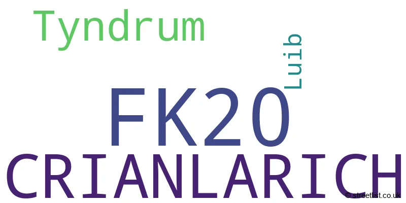
The largest settlement in the FK20 postal code is CRIANLARICH followed by Tyndrum, and Luib.
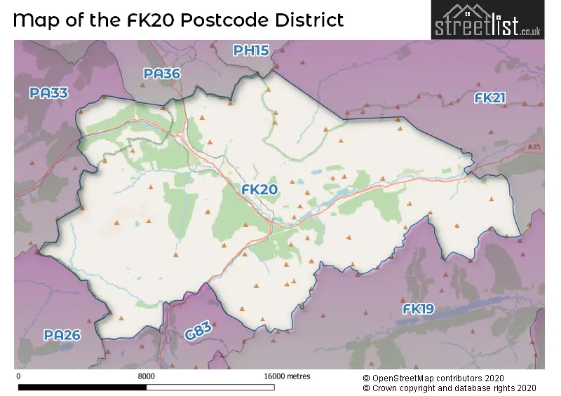
The FK20 Postcode shares a border with G83 (ALEXANDRIA, Balloch, Bonhill), PH15 (ABERFELDY, Glenlyon, Kenmore), FK19 (LOCHEARNHEAD, Balquhidder, Balquhidder Station), FK21 (KILLIN, Glenlochay, Ardeonaig), PA33 (DALMALLY, Lochawe, Portsonachan) and PA36 (BRIDGE OF ORCHY).
The primary settlement in the FK20 postcode district is Crianlarich, located in the county of Stirling and Falkirk in Scotland. Other significant settlements in the district include Luib and Tyndrum, both also located in the county of Stirling and Falkirk. Tyndrum is additionally located in the county of Argyll and Bute. The most significant post town in the district is Crianlarich.
For the district FK20, we have data on 1 postcode sectors. Here's a breakdown: The sector FK20 8, covers Crianlarich and Tyndrum in Stirling and Falkirk.
FK20 Postcode Sectors

Map of the FK20 Postcode District
Explore the FK20 postcode district by using our free interactive map.
When it comes to local government, postal geography often disregards political borders. However, for a breakdown in the FK20 District: the district mostly encompasses the Stirling area with a total of 22 postcodes.
Weather Forecast for FK20
Press Button to Show Forecast for Crianlarich Youth Hostel
| Time Period | Icon | Description | Temperature | Rain Probability | Wind |
|---|---|---|---|---|---|
| 21:00 to 00:00 | Clear night | 7.0°C (feels like 6.0°C) | 0.00% | NNW 4 mph |
Press Button to Show Forecast for Crianlarich Youth Hostel
| Time Period | Icon | Description | Temperature | Rain Probability | Wind |
|---|---|---|---|---|---|
| 00:00 to 03:00 | Clear night | 5.0°C (feels like 3.0°C) | 0.00% | N 2 mph | |
| 03:00 to 06:00 | Clear night | 3.0°C (feels like 1.0°C) | 0.00% | N 2 mph | |
| 06:00 to 09:00 | Sunny day | 3.0°C (feels like 2.0°C) | 0.00% | NW 2 mph | |
| 09:00 to 12:00 | Sunny day | 7.0°C (feels like 6.0°C) | 0.00% | NNW 4 mph | |
| 12:00 to 15:00 | Sunny day | 10.0°C (feels like 9.0°C) | 0.00% | NNW 4 mph | |
| 15:00 to 18:00 | Sunny day | 12.0°C (feels like 10.0°C) | 0.00% | NW 7 mph | |
| 18:00 to 21:00 | Sunny day | 10.0°C (feels like 8.0°C) | 0.00% | NW 9 mph | |
| 21:00 to 00:00 | Partly cloudy (night) | 7.0°C (feels like 5.0°C) | 0.00% | NW 7 mph |
Press Button to Show Forecast for Crianlarich Youth Hostel
| Time Period | Icon | Description | Temperature | Rain Probability | Wind |
|---|---|---|---|---|---|
| 00:00 to 03:00 | Cloudy | 5.0°C (feels like 3.0°C) | 5.00% | NW 4 mph | |
| 03:00 to 06:00 | Partly cloudy (night) | 4.0°C (feels like 2.0°C) | 9.00% | NW 4 mph | |
| 06:00 to 09:00 | Partly cloudy (day) | 4.0°C (feels like 3.0°C) | 2.00% | NNW 2 mph | |
| 09:00 to 12:00 | Cloudy | 7.0°C (feels like 5.0°C) | 9.00% | N 4 mph | |
| 12:00 to 15:00 | Overcast | 8.0°C (feels like 7.0°C) | 9.00% | NNE 4 mph | |
| 15:00 to 18:00 | Cloudy | 9.0°C (feels like 8.0°C) | 8.00% | ENE 4 mph | |
| 18:00 to 21:00 | Cloudy | 8.0°C (feels like 6.0°C) | 9.00% | E 4 mph | |
| 21:00 to 00:00 | Cloudy | 5.0°C (feels like 3.0°C) | 7.00% | ENE 4 mph |
Press Button to Show Forecast for Crianlarich Youth Hostel
| Time Period | Icon | Description | Temperature | Rain Probability | Wind |
|---|---|---|---|---|---|
| 00:00 to 03:00 | Cloudy | 4.0°C (feels like 2.0°C) | 7.00% | ENE 4 mph | |
| 03:00 to 06:00 | Cloudy | 2.0°C (feels like 1.0°C) | 7.00% | NE 2 mph | |
| 06:00 to 09:00 | Cloudy | 3.0°C (feels like 2.0°C) | 10.00% | NE 2 mph | |
| 09:00 to 12:00 | Cloudy | 6.0°C (feels like 4.0°C) | 12.00% | ENE 4 mph | |
| 12:00 to 15:00 | Cloudy | 8.0°C (feels like 6.0°C) | 10.00% | E 4 mph | |
| 15:00 to 18:00 | Cloudy | 8.0°C (feels like 7.0°C) | 11.00% | E 4 mph | |
| 18:00 to 21:00 | Cloudy | 7.0°C (feels like 5.0°C) | 10.00% | E 4 mph | |
| 21:00 to 00:00 | Cloudy | 4.0°C (feels like 3.0°C) | 8.00% | ENE 4 mph |
Press Button to Show Forecast for Crianlarich Youth Hostel
| Time Period | Icon | Description | Temperature | Rain Probability | Wind |
|---|---|---|---|---|---|
| 00:00 to 03:00 | Partly cloudy (night) | 3.0°C (feels like 1.0°C) | 10.00% | NE 4 mph | |
| 03:00 to 06:00 | Cloudy | 2.0°C (feels like 0.0°C) | 13.00% | NE 2 mph | |
| 06:00 to 09:00 | Cloudy | 3.0°C (feels like 1.0°C) | 12.00% | NE 4 mph | |
| 09:00 to 12:00 | Cloudy | 6.0°C (feels like 4.0°C) | 14.00% | E 7 mph | |
| 12:00 to 15:00 | Overcast | 8.0°C (feels like 7.0°C) | 18.00% | ESE 7 mph | |
| 15:00 to 18:00 | Light rain shower (day) | 9.0°C (feels like 7.0°C) | 40.00% | ESE 7 mph | |
| 18:00 to 21:00 | Light rain | 8.0°C (feels like 6.0°C) | 49.00% | ENE 7 mph | |
| 21:00 to 00:00 | Cloudy | 5.0°C (feels like 3.0°C) | 18.00% | ENE 4 mph |
Where is the FK20 Postcode District?
The FK20 postcode district is located in Crianlarich. Crianlarich is surrounded by several nearby towns. To the North West, there is Bridge of Orchy which is approximately 10.1 miles away. To the East, there is Lochearnhead which is about 11.2 miles away. To the South, there is Stirling which is around 14.1 miles away. To the South West, there is Cairndow which is approximately 14.3 miles away. To the West, there is Dalmally which is about 17.1 miles away. Lastly, to the South East, there is Callander which is around 17.3 miles away. In addition, the distance from Crianlarich to the centre of London is approximately 385.1 miles.
The district is within the post town of CRIANLARICH.
The sector has postcodes within the nation of Scotland.
The FK20 Postcode District is covers the following regions.
- Perth & Kinross and Stirling - Eastern Scotland - Scotland
- Lochaber, Skye & Lochalsh, Arran & Cumbrae and Argyll & Bute - Highlands and Islands - Scotland
- East Dunbartonshire, West Dunbartonshire and Helensburgh & Lomond - West Central Scotland - Scotland
Postcode Sectors within the FK20 District
| Postcode Sector | Delivery Office |
|---|---|
| FK20 8 | Crianlarich Scale Payment Delivery Office |
| F | K | 2 | 0 | - | X | X | X |
| F | K | 2 | 0 | Space | Numeric | Letter | Letter |
Current Monthly Rental Prices
| # Bedrooms | Min Price | Max Price | Avg Price |
|---|
Current House Prices
| # Bedrooms | Min Price | Max Price | Avg Price |
|---|---|---|---|
| 2 | £80,000 | £300,000 | £170,000 |
| 3 | £70,000 | £165,000 | £117,500 |
| 4 | £485,000 | £485,000 | £485,000 |
| 5 | £475,000 | £475,000 | £475,000 |
| 8 | £700,000 | £700,000 | £700,000 |
Estate Agents who Operate in the FK20 District
| Logo | Name | Brand Name | Address | Contact Number | Total Properties |
|---|---|---|---|---|---|
 | covering Falkirk | Purplebricks | Suite 7 First Floor Cranmore Drive Shirley Solihull B90 4RZ | 020 3908 0006 | 4 |
 | Stirling | Galbraith | Suite C1, Stirling Agricultural Centre, Stirling, FK9 4RN | 01786 649945 | 1 |
 | Edinburgh | McEwan Fraser Legal | Claremont House 130 East Claremont Street Edinburgh EH7 4LB | 0131 381 4292 | 1 |
 | Edinburgh | Strutt & Parker | 76 George Street Edinburgh EH2 3BU | 0131 381 0648 | 1 |
 | Fort William | West & Peter Murphy | 1A Sheraton Retail Park Lochybridge Fort William PH33 7NU | 01631 708256 | 1 |