The FY5 4 postcode sector is within the county of Lancashire.
Did you know? According to the 2021 Census, the FY5 4 postcode sector is home to a bustling 8,324 residents!
Given that each sector allows for 400 unique postcode combinations. Letters C, I, K, M, O and V are not allowed in the last two letters of a postcode. With 199 postcodes already in use, this leaves 201 units available.
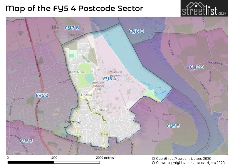
The largest settlements in the FY5 4 postal code are THORNTON-CLEVELEYS and Red Marsh Industrial Estate.
The FY5 4 Postcode shares a border with FY5 2 (THORNTON-CLEVELEYS), FY5 5 (THORNTON-CLEVELEYS), FY7 8 (FLEETWOOD) and FY5 3 (THORNTON-CLEVELEYS).
The sector is within the post town of THORNTON-CLEVELEYS.
FY5 4 is a postcode sector within the FY5 postcode district which is within the FY The Fylde postcode area.
The Royal Mail delivery office for the FY5 4 postal sector is the Cleveleys Delivery Office.
The area of the FY5 4 postcode sector is 1.22 square miles which is 3.16 square kilometres or 781.16 square acres.

Map of the FY5 4 Postcode Sector
Explore the FY5 4 postcode sector by using our free interactive map.
| F | Y | 5 | - | 4 | X | X |
| F | Y | 5 | Space | 4 | Letter | Letter |
Official List of Streets
THORNTON-CLEVELEYS (135 Streets)
Red Marsh Industrial Estate (3 Streets)
Unofficial Streets or Alternative Spellings
THORNTON-CLEVELEYS
BOURNE ROAD CHURCH ROAD COUNSELL COURT DEVONSHIRE MEWS DOVEDALE AVENUE PATTERDALE AVENUE POACHERS WAY RETA DRIVE TORENTUM COURT WARING DRIVE WELBURN WALK WEST DRIVE ASHDELL CLOSE BRAYS HEY CROFT COURT HEATHER CLOSE HOLLY CLOSE KINGSTON MEWS LAWSONS COURT LINADALE AVENUE MAGNOLIA MEWS MARSH MILL VILLAGE ROYLES COURT THE GRANARY THE HAWTHORNES TORENTUN CLOSE WESTFIELD COURTFLEETWOOD
FLEETWOOD ROADWeather Forecast for FY5 4
Press Button to Show Forecast for Wyre
| Time Period | Icon | Description | Temperature | Rain Probability | Wind |
|---|---|---|---|---|---|
| 06:00 to 09:00 | Cloudy | 8.0°C (feels like 4.0°C) | 33.00% | NNW 16 mph | |
| 09:00 to 12:00 | Partly cloudy (day) | 8.0°C (feels like 5.0°C) | 31.00% | NNW 11 mph | |
| 12:00 to 15:00 | Partly cloudy (day) | 8.0°C (feels like 5.0°C) | 4.00% | NNW 11 mph | |
| 15:00 to 18:00 | Cloudy | 9.0°C (feels like 6.0°C) | 4.00% | NNW 11 mph | |
| 18:00 to 21:00 | Cloudy | 9.0°C (feels like 7.0°C) | 4.00% | ENE 9 mph | |
| 21:00 to 00:00 | Cloudy | 8.0°C (feels like 5.0°C) | 5.00% | E 9 mph |
Press Button to Show Forecast for Wyre
| Time Period | Icon | Description | Temperature | Rain Probability | Wind |
|---|---|---|---|---|---|
| 00:00 to 03:00 | Clear night | 6.0°C (feels like 3.0°C) | 1.00% | E 9 mph | |
| 03:00 to 06:00 | Clear night | 5.0°C (feels like 2.0°C) | 1.00% | ENE 7 mph | |
| 06:00 to 09:00 | Sunny day | 5.0°C (feels like 2.0°C) | 1.00% | ENE 7 mph | |
| 09:00 to 12:00 | Sunny day | 6.0°C (feels like 4.0°C) | 1.00% | NE 7 mph | |
| 12:00 to 15:00 | Cloudy | 8.0°C (feels like 6.0°C) | 6.00% | N 4 mph | |
| 15:00 to 18:00 | Cloudy | 8.0°C (feels like 6.0°C) | 6.00% | NNW 9 mph | |
| 18:00 to 21:00 | Cloudy | 9.0°C (feels like 7.0°C) | 7.00% | N 7 mph | |
| 21:00 to 00:00 | Partly cloudy (night) | 8.0°C (feels like 6.0°C) | 3.00% | NE 9 mph |
Press Button to Show Forecast for Wyre
| Time Period | Icon | Description | Temperature | Rain Probability | Wind |
|---|---|---|---|---|---|
| 00:00 to 03:00 | Partly cloudy (night) | 6.0°C (feels like 4.0°C) | 3.00% | E 9 mph | |
| 03:00 to 06:00 | Partly cloudy (night) | 6.0°C (feels like 3.0°C) | 4.00% | E 7 mph | |
| 06:00 to 09:00 | Partly cloudy (day) | 6.0°C (feels like 4.0°C) | 4.00% | E 7 mph | |
| 09:00 to 12:00 | Partly cloudy (day) | 8.0°C (feels like 6.0°C) | 4.00% | E 7 mph | |
| 12:00 to 15:00 | Cloudy | 9.0°C (feels like 7.0°C) | 9.00% | NNE 7 mph | |
| 15:00 to 18:00 | Cloudy | 10.0°C (feels like 8.0°C) | 10.00% | NE 7 mph | |
| 18:00 to 21:00 | Cloudy | 10.0°C (feels like 8.0°C) | 11.00% | ENE 9 mph | |
| 21:00 to 00:00 | Cloudy | 9.0°C (feels like 6.0°C) | 12.00% | NE 11 mph |
Press Button to Show Forecast for Wyre
| Time Period | Icon | Description | Temperature | Rain Probability | Wind |
|---|---|---|---|---|---|
| 00:00 to 03:00 | Cloudy | 7.0°C (feels like 4.0°C) | 14.00% | NE 11 mph | |
| 03:00 to 06:00 | Cloudy | 7.0°C (feels like 3.0°C) | 14.00% | NNE 13 mph | |
| 06:00 to 09:00 | Cloudy | 7.0°C (feels like 4.0°C) | 16.00% | NNE 13 mph | |
| 09:00 to 12:00 | Cloudy | 8.0°C (feels like 5.0°C) | 15.00% | NNE 13 mph | |
| 12:00 to 15:00 | Light rain shower (day) | 9.0°C (feels like 7.0°C) | 37.00% | NNE 11 mph | |
| 15:00 to 18:00 | Light rain | 10.0°C (feels like 8.0°C) | 45.00% | NNE 9 mph | |
| 18:00 to 21:00 | Sunny day | 10.0°C (feels like 7.0°C) | 13.00% | NNW 16 mph | |
| 21:00 to 00:00 | Partly cloudy (night) | 9.0°C (feels like 7.0°C) | 8.00% | NW 13 mph |
Schools and Places of Education Within the FY5 4 Postcode Sector
Great Arley School
Community special school
Holly Road, Thornton-Cleveleys, Lancashire, FY5 4HH
Head: Mr Peter Higham
Ofsted Rating: Good
Inspection: 2018-10-09 (2025 days ago)
Website: Visit Great Arley School Website
Phone: 01253821072
Number of Pupils: 107
Thornton Primary School
Community school
Heys Street, Thornton-Cleveleys, Lancashire, FY5 4JP
Head: Mr David Ashcroft
Ofsted Rating: Good
Inspection: 2023-02-23 (427 days ago)
Website: Visit Thornton Primary School Website
Phone: 01253821128
Number of Pupils: 135
Thornton-Cleveleys Red Marsh School
Community special school
Holly Road, Blackpool, Lancashire, FY5 4HH
Head: Mrs Jenny Slater
Ofsted Rating: Outstanding
Inspection: 2019-02-07 (1904 days ago)
Website: Visit Thornton-Cleveleys Red Marsh School Website
Phone: 01253868451
Number of Pupils: 106
House Prices in the FY5 4 Postcode Sector
| Type of Property | 2018 Average | 2018 Sales | 2017 Average | 2017 Sales | 2016 Average | 2016 Sales | 2015 Average | 2015 Sales |
|---|---|---|---|---|---|---|---|---|
| Detached | £200,729 | 28 | £202,281 | 30 | £193,822 | 32 | £203,384 | 31 |
| Semi-Detached | £133,208 | 89 | £127,481 | 86 | £122,137 | 70 | £115,547 | 64 |
| Terraced | £116,794 | 57 | £115,129 | 57 | £109,040 | 65 | £120,078 | 62 |
| Flats | £67,056 | 9 | £81,900 | 5 | £74,083 | 6 | £64,300 | 6 |
Important Postcodes FY5 4 in the Postcode Sector
FY5 4HH is the postcode for Great Arley School, Holly Road, and Red Marsh School, Holly Road
FY5 4HL is the postcode for Sacred Heart School, Heys Street
FY5 4JP is the postcode for Thornton Primary School, Heys Street
| The FY5 4 Sector is within these Local Authorities |
|
|---|---|
| The FY5 4 Sector is within these Counties |
|
| The FY5 4 Sector is within these Water Company Areas |
|