This section of the site is all about the G Postcode area, also known as the Glasgow Postal Area. Explore links to the next level to learn more about specific postcode districts such as G1.
The G postcode area represents a group of postal districts in the Glasgow area of the United Kingdom. The area code G stands for the letters g in Glasgow. G has a population of 1,184,619 and covers an area of 1,802,095 hectares. Fun fact: 1.82% of the population of Great Britain lives in this area.
The postcode area falls within the following counties: City of Glasgow (54.81%), Dunbartonshire (21.84%), Lanarkshire (15.03%), Renfrewshire (7.16%), Stirling and Falkirk (1.13%), Ayrshire and Arran (0.02%), Argyll and Bute (0.02%).
Post Towns and Postcode Districts for the G Postcode
-
G1 City of GlasgowG2 City of GlasgowG3 City of GlasgowG4 City of GlasgowG5 City of GlasgowG9 G11 City of GlasgowG12 City of GlasgowG13 City of GlasgowG14 City of GlasgowG15 City of GlasgowG20 City of GlasgowG21 City of GlasgowG22 City of GlasgowG23 City of GlasgowG31 City of GlasgowG32 City of GlasgowG33 City of Glasgow (86%), Lanarkshire (13%)G34 City of GlasgowG40 City of GlasgowG41 City of GlasgowG42 City of GlasgowG43 City of Glasgow (95%), Renfrewshire (4%)G44 City of Glasgow (83%), Renfrewshire (16%)G45 City of GlasgowG46 City of Glasgow (29%), Renfrewshire (70%)G51 City of GlasgowG52 City of Glasgow (78%), Renfrewshire (21%)G53 City of GlasgowG58 G60 DunbartonshireG61 City of Glasgow (1%), Dunbartonshire (98%)G62 Dunbartonshire (98%), Stirling and Falkirk (1%)G63 Dunbartonshire (1%), Stirling and Falkirk (98%)G64 City of Glasgow (1%), Dunbartonshire (98%)G65 DunbartonshireG66 Dunbartonshire (97%), Lanarkshire (2%)G67 Dunbartonshire (97%), Lanarkshire (2%)G68 DunbartonshireG69 City of Glasgow (46%), Lanarkshire (53%)G70 G71 City of Glasgow (6%), Lanarkshire (93%)G72 LanarkshireG73 LanarkshireG74 LanarkshireG75 LanarkshireG76 City of Glasgow (7%), Lanarkshire (2%), Renfrewshire (89%)G77 RenfrewshireG78 RenfrewshireG79 G90
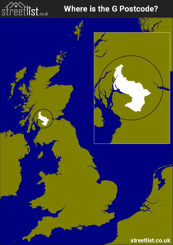
Where is the G Postcode Area?
The G Glasgow Postcode is in Scotland. The postal area borders the following neighbouring postal areas: PA - Paisley, KA - Kilmarnock, FK - Falkirk and ML - Motherwell, It also borders The Firth of Clyde,
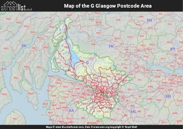
Map of the G Glasgow Postcode Area
Explore the G Glasgow postcode area by using our interactive map.
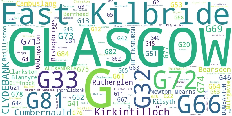
Postcode Districts within the G Glasgow Postcode Area
There are 50 postcode districts within the Glasgow postcode area
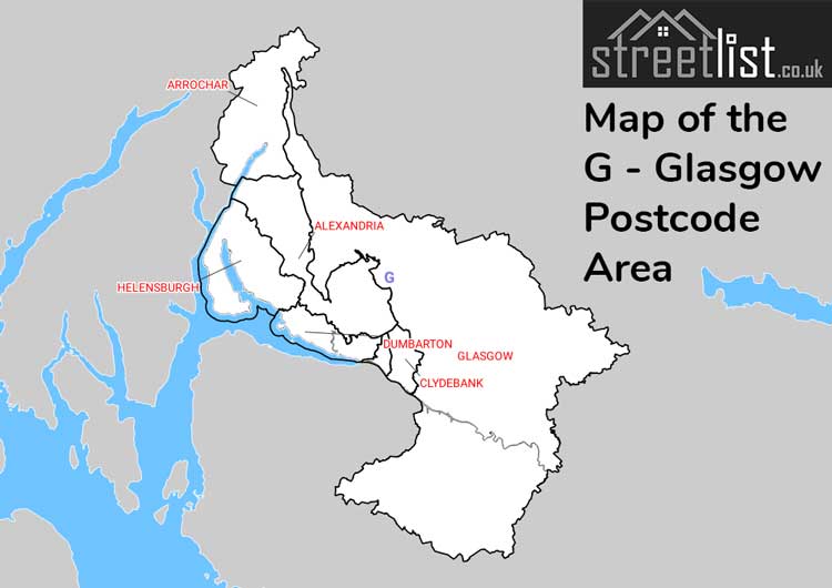
A map showing the boundary of in relation to other areas
There are 18 towns within the Glasgow postcode area.
| Unit | Area² |
|---|---|
| Hectares | 1,802,095² |
| Miles | 6,958² |
| Feet | 193,975,703,705² |
| Kilometres | 18,021² |
Postal Delivery Offices serving the G Glasgow Postcode Area
- Alexandria Delivery Office
- Baillieston Delivery Office
- Balfron Scale Payment Delivery Office
- Barrhead Delivery Office
- Bearsden Delivery Office
- Bishopbriggs Delivery Office
- Clarkston Delivery Office
- Clydebank Delivery Office
- Cumbernauld Delivery Office
- Drymen Scale Payment Delivery Office
- Dumbarton Delivery Office
- Dumgoyne Scale Payment Delivery Office
- East Kilbride Delivery Office
- Glasgow G1/4 Delivery Office
- Glasgow G11/12 Delivery Office
- Glasgow G13/14 Delivery Office
- Glasgow G15 Delivery Office
- Glasgow G20/23 Delivery Office
- Glasgow G21/22 Delivery Office
- Glasgow G31 Delivery Office
- Glasgow G32 Delivery Office
- Glasgow G33/34 Delivery Office
- Glasgow G40 Delivery Office
- Glasgow G41/42/5 Delivery Office
- Glasgow G43/46 Delivery Office
- Glasgow G44 Delivery Office
- Glasgow G45 Delivery Office
- Glasgow G51 Delivery Office
- Glasgow G52 Delivery Office
- Glasgow G53 Delivery Office
- Helensburgh Delivery Office
- Kilsyth Delivery Office
- Kirkintilloch Delivery Office
- Milngavie Delivery Office
- Newton Mearns Delivery Office
- Rutherglen Delivery Office
- Strathblane Scale Payment Delivery Office
- Uddingston Delivery Office
Councils with Postcodes in G
Towns and Villages within the G Glasgow Postcode Area
- Alexandria - town
- Ardlui - otherSettlement
- Ardpeaton - village
- Arrochar - village
- Auchenreoch - otherSettlement
- Auchinloch - village
- Balfron - village
- Balloch and Haldane -
- Balmore - village
- Banton - village
- Bardowie - village
- Bargeddie - village
- Barrhead - town
- Bearsden - town
- Bishopbriggs - town
- Blantyre - Settlement
- Bonhill - village
- Bothwell - Settlement
- Bowling - village
- Busby - village
- Cambuslang - Settlement
- Cardross - village
- Carmunnock - village
- Chryston - village
- Clarkston -
- Clydebank - town
- Coatbridge - town
- Croftamie - village
- Croy -
- Cumbernauld - town
- Dalton - otherSettlement
- Drymen - village
- Dullatur - village
- Dumbarton - town
- Duntocher and Hardgate -
- Eaglesham - village
- East Kilbride - town
- Faifley -
- Fintry - village
- Garelochhead - village
- Gartcosh - village
- Gartloch -
- Gartocharn - village
- Giffnock -
- Glasgow - city
- Glenboig - village
- Hamilton - town
- Haughhead - village
- Helensburgh - town
- Kilcreggan - village
- Killearn - village
- Kilsyth - town
- Kirkintilloch - town
- Lennoxtown - village
- Lenzie -
- Luss - village
- Milngavie - town
- Milton -
- Milton of Buchanan - village
- Milton of Campsie - village
- Moodiesburn - village
- Mugdock - village
- Muirhead -
- Neilston - village
- Netherlee -
- Newton Mearns - Settlement
- Old Kilpatrick -
- Paisley - town
- Portincaple - village
- Queenzieburn - village
- Renfrew - town
- Renton - village
- Rhu - village
- Rosneath - village
- Rutherglen - town
- Stamperland -
- Stepps - village
- Strathblane - village
- Succoth - village
- Tarbet - village
- Thornliebank -
- Thorntonhall - village
- Torrance - village
- Twechar - village
- Uddingston - town
- Uplawmoor - village
- Viewpark - urban area
- Waterfoot - village