The G42 postcode district is a postal district located in the G Glasgow postcode area with a population of 28,033 residents according to the 2011 Scotland Census.
The area of the G42 postcode district is 1.68 square miles which is 4.36 square kilometres or 1,076.24 acres.
Currently, the G42 district has about 638 postcode units spread across 4 geographic postcode sectors.
Given that each sector allows for 400 unique postcode combinations, the district has a capacity of 1,600 postcodes. With 638 postcodes already in use, this leaves 962 units available.
The G42 postal code covers the settlement of GLASGOW.
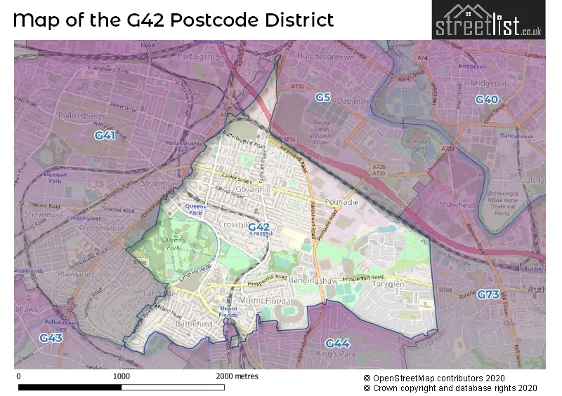
The G42 Postcode shares a border with G43 (GLASGOW), G44 (GLASGOW), G41 (GLASGOW) and G5 (GLASGOW).
The primary settlement in the G42 postcode district is Glasgow, which is located in the City of Glasgow in Scotland. The most significant Postal Town in this district is also Glasgow.
For the district G42, we have data on 5 postcode sectors. Here's a breakdown: The sector G42 0, covers Glasgow in City of Glasgow. The sector G42 2 is non-geographic. It's often designated for PO Boxes, large organisations, or special services. The sector G42 7, covers Glasgow in City of Glasgow. The sector G42 8, covers Glasgow in City of Glasgow. The sector G42 9, covers Glasgow in City of Glasgow.


Map of the G42 Postcode District
Explore the G42 postcode district by using our free interactive map.
When it comes to local government, postal geography often disregards political borders. However, for a breakdown in the G42 District: the district mostly encompasses the Glasgow City area with a total of 639 postcodes.
Weather Forecast for G42
Press Button to Show Forecast for Hampden Park
| Time Period | Icon | Description | Temperature | Rain Probability | Wind |
|---|---|---|---|---|---|
| 21:00 to 00:00 | Cloudy | 6.0°C (feels like 3.0°C) | 5.00% | E 7 mph |
Press Button to Show Forecast for Hampden Park
| Time Period | Icon | Description | Temperature | Rain Probability | Wind |
|---|---|---|---|---|---|
| 00:00 to 03:00 | Cloudy | 4.0°C (feels like 3.0°C) | 5.00% | ENE 4 mph | |
| 03:00 to 06:00 | Partly cloudy (night) | 3.0°C (feels like 2.0°C) | 1.00% | ENE 4 mph | |
| 06:00 to 09:00 | Sunny day | 3.0°C (feels like 2.0°C) | 1.00% | ENE 2 mph | |
| 09:00 to 12:00 | Partly cloudy (day) | 7.0°C (feels like 6.0°C) | 1.00% | NE 2 mph | |
| 12:00 to 15:00 | Cloudy | 9.0°C (feels like 8.0°C) | 9.00% | N 4 mph | |
| 15:00 to 18:00 | Cloudy | 10.0°C (feels like 9.0°C) | 8.00% | NNE 2 mph | |
| 18:00 to 21:00 | Cloudy | 8.0°C (feels like 7.0°C) | 10.00% | NNW 4 mph | |
| 21:00 to 00:00 | Cloudy | 6.0°C (feels like 5.0°C) | 8.00% | E 4 mph |
Press Button to Show Forecast for Hampden Park
| Time Period | Icon | Description | Temperature | Rain Probability | Wind |
|---|---|---|---|---|---|
| 00:00 to 03:00 | Partly cloudy (night) | 5.0°C (feels like 4.0°C) | 2.00% | ESE 2 mph | |
| 03:00 to 06:00 | Partly cloudy (night) | 4.0°C (feels like 2.0°C) | 1.00% | ESE 2 mph | |
| 06:00 to 09:00 | Partly cloudy (day) | 4.0°C (feels like 2.0°C) | 2.00% | ESE 2 mph | |
| 09:00 to 12:00 | Partly cloudy (day) | 8.0°C (feels like 7.0°C) | 4.00% | SE 2 mph | |
| 12:00 to 15:00 | Overcast | 10.0°C (feels like 9.0°C) | 14.00% | SSE 4 mph | |
| 15:00 to 18:00 | Cloudy | 10.0°C (feels like 9.0°C) | 15.00% | SSE 4 mph | |
| 18:00 to 21:00 | Cloudy | 9.0°C (feels like 8.0°C) | 12.00% | SE 4 mph | |
| 21:00 to 00:00 | Clear night | 6.0°C (feels like 5.0°C) | 5.00% | SE 4 mph |
Press Button to Show Forecast for Hampden Park
| Time Period | Icon | Description | Temperature | Rain Probability | Wind |
|---|---|---|---|---|---|
| 00:00 to 03:00 | Clear night | 5.0°C (feels like 4.0°C) | 5.00% | E 4 mph | |
| 03:00 to 06:00 | Clear night | 4.0°C (feels like 2.0°C) | 5.00% | ENE 4 mph | |
| 06:00 to 09:00 | Partly cloudy (day) | 4.0°C (feels like 3.0°C) | 6.00% | NE 4 mph | |
| 09:00 to 12:00 | Partly cloudy (day) | 7.0°C (feels like 6.0°C) | 10.00% | NNE 7 mph | |
| 12:00 to 15:00 | Cloudy | 10.0°C (feels like 9.0°C) | 15.00% | NNE 7 mph | |
| 15:00 to 18:00 | Cloudy | 11.0°C (feels like 10.0°C) | 15.00% | NNW 7 mph | |
| 18:00 to 21:00 | Partly cloudy (day) | 10.0°C (feels like 8.0°C) | 11.00% | NW 9 mph | |
| 21:00 to 00:00 | Partly cloudy (night) | 7.0°C (feels like 5.0°C) | 10.00% | W 7 mph |
Where is the G42 Postcode District?
The postcode district G42 is located in the town of Glasgow. It is situated near several other towns, including St. Andrews, Ayr, Alloa, Aberdeen, Irvine, and Renfrew. Additionally, G42 is approximately 343.5 miles away from the center of London.
The district is within the post town of GLASGOW.
The sector has postcodes within the nation of Scotland.
The G42 Postcode District is in the Glasgow City region of West Central Scotland within the Scotland.
| Postcode Sector | Delivery Office |
|---|---|
| G42 0 | Glasgow G41/42/5 Delivery Office |
| G42 7 | Glasgow G41/42/5 Delivery Office |
| G42 8 | Glasgow G41/42/5 Delivery Office |
| G42 9 | Glasgow G41/42/5 Delivery Office |
| G | 4 | 2 | - | X | X | X |
| G | 4 | 2 | Space | Numeric | Letter | Letter |
Current Monthly Rental Prices
| # Bedrooms | Min Price | Max Price | Avg Price |
|---|---|---|---|
| £650 | £650 | £650 | |
| 1 | £595 | £775 | £712 |
| 2 | £850 | £1,300 | £1,024 |
| 4 | £1,950 | £1,950 | £1,950 |
Current House Prices
| # Bedrooms | Min Price | Max Price | Avg Price |
|---|---|---|---|
| £30,000 | £30,000 | £30,000 | |
| 1 | £47,500 | £125,000 | £95,227 |
| 2 | £100,000 | £345,000 | £168,360 |
| 3 | £90,000 | £105,000 | £97,500 |
Estate Agents who Operate in the G42 District
| Logo | Name | Brand Name | Address | Contact Number | Total Properties |
|---|---|---|---|---|---|
 | Shawlands | Clyde Property | 226 Kilmarnock Road, Glasgow, G43 1TY | 0141 673 5143 | 8 |
 | Glasgow | 1st Lets Glasgow | 2 Calder Street Glasgow G42 7RT | 0141 673 9374 | 5 |
 | Shawlands, Glasgow | Slater Hogg & Howison | 255-257 Kilmarnock Road, Shawlands, Glasgow G41 3JF | 0141 673 7686 | 4 |
 | Shawlands | Rettie & Co | 196 Kilmarnock Road, Glasgow, G41 3PG | 0141 673 6578 | 4 |
 | Shawlands | Scottish Property Centre | 157 Kilmarnock Road, Shawlands, Glasgow G41 3JE | 0141 673 3201 | 4 |