The G68 postcode district is a postal district located in the G Glasgow postcode area with a population of 18,433 residents according to the 2011 Scotland Census.
The area of the G68 postcode district is 8.13 square miles which is 21.05 square kilometres or 5,202.44 acres.
Currently, the G68 district has about 330 postcode units spread across 2 geographic postcode sectors.
Given that each sector allows for 400 unique postcode combinations, the district has a capacity of 800 postcodes. With 330 postcodes already in use, this leaves 470 units available.
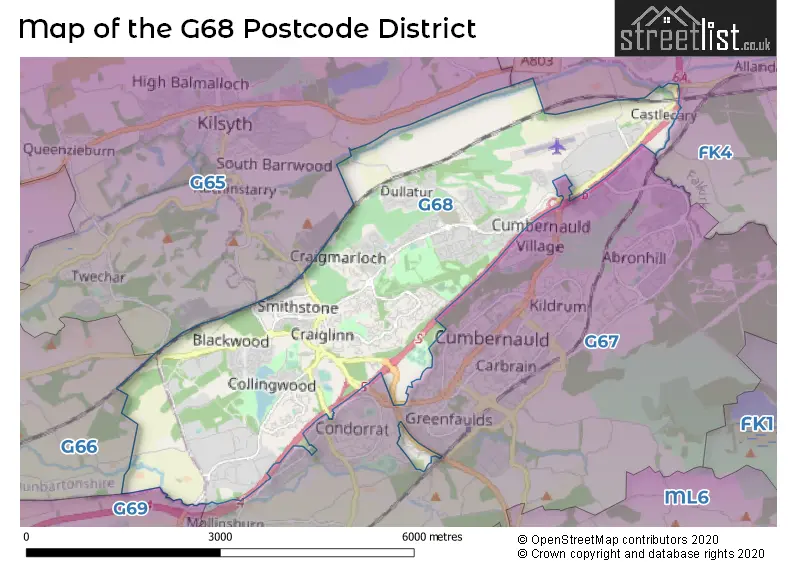
The largest settlements in the G68 postal code are Cumbernauld and Dullatur.
The G68 Postcode shares a border with G69 (Baillieston, Chryston, Gartcosh), G65 (Kilsyth), FK4 (BONNYBRIDGE, Banknock, Dennyloanhead) and G67 (Cumbernauld).
The primary settlement in the G68 postcode district is Cumbernauld in Dunbartonshire, Scotland. Other significant settlements in the district include Dullatur. The most significant post town is Glasgow.
For the district G68, we have data on 2 postcode sectors. Here's a breakdown: The sector G68 0, covers Cumbernauld and Dullatur in Dunbartonshire. The sector G68 9, covers Cumbernauld in Dunbartonshire.

Map of the G68 Postcode District
Explore the G68 postcode district by using our free interactive map.
When it comes to local government, postal geography often disregards political borders. However, for a breakdown in the G68 District: the district mostly encompasses the North Lanarkshire (324 postcodes), and finally, the East Dunbartonshire area (3 postcodes).
Weather Forecast for G68
Press Button to Show Forecast for Cumbernauld
| Time Period | Icon | Description | Temperature | Rain Probability | Wind |
|---|---|---|---|---|---|
| 00:00 to 03:00 | Cloudy | 3.0°C (feels like 1.0°C) | 4.00% | NE 4 mph | |
| 03:00 to 06:00 | Cloudy | 2.0°C (feels like 0.0°C) | 4.00% | NNE 2 mph | |
| 06:00 to 09:00 | Partly cloudy (day) | 2.0°C (feels like 0.0°C) | 2.00% | N 2 mph | |
| 09:00 to 12:00 | Cloudy | 6.0°C (feels like 5.0°C) | 4.00% | NE 2 mph | |
| 12:00 to 15:00 | Cloudy | 8.0°C (feels like 6.0°C) | 9.00% | NE 4 mph | |
| 15:00 to 18:00 | Cloudy | 9.0°C (feels like 8.0°C) | 7.00% | NNE 2 mph | |
| 18:00 to 21:00 | Cloudy | 7.0°C (feels like 6.0°C) | 7.00% | E 4 mph | |
| 21:00 to 00:00 | Partly cloudy (night) | 5.0°C (feels like 3.0°C) | 5.00% | SE 4 mph |
Press Button to Show Forecast for Cumbernauld
| Time Period | Icon | Description | Temperature | Rain Probability | Wind |
|---|---|---|---|---|---|
| 00:00 to 03:00 | Partly cloudy (night) | 3.0°C (feels like 1.0°C) | 2.00% | NE 4 mph | |
| 03:00 to 06:00 | Partly cloudy (night) | 2.0°C (feels like 0.0°C) | 2.00% | NNE 2 mph | |
| 06:00 to 09:00 | Mist | 3.0°C (feels like 1.0°C) | 13.00% | NE 2 mph | |
| 09:00 to 12:00 | Partly cloudy (day) | 6.0°C (feels like 5.0°C) | 4.00% | E 4 mph | |
| 12:00 to 15:00 | Overcast | 9.0°C (feels like 8.0°C) | 14.00% | SE 4 mph | |
| 15:00 to 18:00 | Cloudy | 9.0°C (feels like 7.0°C) | 13.00% | SSE 7 mph | |
| 18:00 to 21:00 | Cloudy | 8.0°C (feels like 6.0°C) | 14.00% | ESE 4 mph | |
| 21:00 to 00:00 | Clear night | 5.0°C (feels like 4.0°C) | 5.00% | ESE 4 mph |
Press Button to Show Forecast for Cumbernauld
| Time Period | Icon | Description | Temperature | Rain Probability | Wind |
|---|---|---|---|---|---|
| 00:00 to 03:00 | Clear night | 4.0°C (feels like 3.0°C) | 6.00% | N 2 mph | |
| 03:00 to 06:00 | Clear night | 2.0°C (feels like 0.0°C) | 6.00% | NNE 4 mph | |
| 06:00 to 09:00 | Partly cloudy (day) | 3.0°C (feels like 1.0°C) | 10.00% | NNE 4 mph | |
| 09:00 to 12:00 | Cloudy | 6.0°C (feels like 4.0°C) | 13.00% | NNE 7 mph | |
| 12:00 to 15:00 | Cloudy | 9.0°C (feels like 8.0°C) | 15.00% | NNE 7 mph | |
| 15:00 to 18:00 | Cloudy | 10.0°C (feels like 9.0°C) | 16.00% | NNW 7 mph | |
| 18:00 to 21:00 | Partly cloudy (day) | 10.0°C (feels like 7.0°C) | 10.00% | NNW 9 mph | |
| 21:00 to 00:00 | Partly cloudy (night) | 6.0°C (feels like 4.0°C) | 9.00% | NW 7 mph |
Where is the G68 Postcode District?
The data suggests that the postcode district G68 is in the town of Glasgow. It is located near several other towns, including Bonnybridge, Airdrie, Coatbridge, Irvine, and Falkirk. The distance to the center of London from this postcode district is approximately 346.25 miles.
The district is within the post town of GLASGOW.
The sector has postcodes within the nation of Scotland.
The G68 Postcode District is in the East Dunbartonshire, West Dunbartonshire and Helensburgh & Lomond region of West Central Scotland within the Scotland.
| Postcode Sector | Delivery Office |
|---|---|
| G68 0 | Cumbernauld Delivery Office |
| G68 9 | Cumbernauld Delivery Office |
| G | 6 | 8 | - | X | X | X |
| G | 6 | 8 | Space | Numeric | Letter | Letter |
Current Monthly Rental Prices
| # Bedrooms | Min Price | Max Price | Avg Price |
|---|---|---|---|
| 2 | £700 | £760 | £730 |
Current House Prices
| # Bedrooms | Min Price | Max Price | Avg Price |
|---|---|---|---|
| 1 | £90,000 | £100,000 | £95,000 |
| 2 | £100,000 | £165,000 | £128,490 |
| 3 | £139,995 | £265,000 | £200,394 |
| 4 | £150,000 | £440,000 | £318,994 |
| 5 | £365,000 | £875,000 | £481,000 |
| 6 | £410,000 | £410,000 | £410,000 |
Estate Agents who Operate in the G68 District
| Logo | Name | Brand Name | Address | Contact Number | Total Properties |
|---|---|---|---|---|---|
 | Cumbernauld | Slater Hogg & Howison | 11 Tay Walk Cumbernauld G67 1BU | 01236 807670 | 12 |
 | Cumbernauld | K Property | 8 Ettrick Square, Cumbernauld, G67 1ND | 01236 807680 | 5 |
 | Cumbernauld | Village Estates | 2 The Wynd, Cumbernauld, G67 2SU | 01236 807675 | 5 |
 | Cumbernauld | Nest Estate Agents | 7 Tay Walk, Cumbernauld, G67 1BU | 01236 807693 | 2 |
 | covering Glasgow | Purplebricks | Suite 7 First Floor Cranmore Drive Shirley Solihull B90 4RZ | 020 3910 6765 | 2 |