The G84 postcode district is a postal district located in the G Glasgow postcode area with a population of 21,834 residents according to the 2011 Scotland Census.
The area of the G84 postcode district is 48.69 square miles which is 126.10 square kilometres or 31,160.89 acres.
Currently, the G84 district has about 865 postcode units spread across 4 geographic postcode sectors.
Given that each sector allows for 400 unique postcode combinations, the district has a capacity of 1,600 postcodes. With 865 postcodes already in use, this leaves 735 units available.
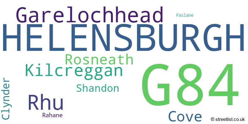
The largest settlement in the G84 postal code is HELENSBURGH followed by Garelochhead, and Rosneath.
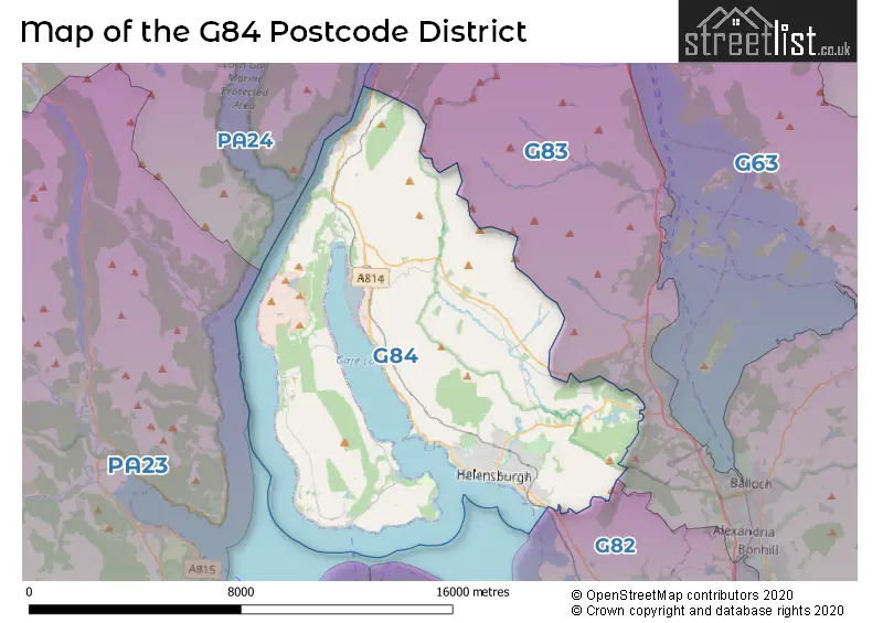
The postcode area has a boundary with Firth of Clyde.
The G84 Postcode shares a border with G82 (DUMBARTON, Renton, Cardross) and G83 (ALEXANDRIA, Balloch, Bonhill).
The primary settlement in the G84 postcode district is Garelochhead, located in the county of Dunbartonshire, Scotland. Other significant settlements in this district include Clynder, Cove, Kilcreggan, Rahane, and Rosneath. The main post town for this district is Helensburgh.
For the district G84, we have data on 5 postcode sectors. Here's a breakdown: The sector G84 0, covers Garelochhead and Kilcreggan and Cove and Rosneath in Dunbartonshire. The sector G84 4 is non-geographic. It's often designated for PO Boxes, large organisations, or special services. The sector G84 7, covers Helensburgh in Dunbartonshire. The sector G84 8, covers Helensburgh and Rhu in Dunbartonshire. The sector G84 9, covers Helensburgh in Dunbartonshire.

Map of the G84 Postcode District
Explore the G84 postcode district by using our free interactive map.
When it comes to local government, postal geography often disregards political borders. However, for a breakdown in the G84 District: the district mostly encompasses the Argyll and Bute area with a total of 871 postcodes.
Weather Forecast for G84
Press Button to Show Forecast for Gare Loch
| Time Period | Icon | Description | Temperature | Rain Probability | Wind |
|---|---|---|---|---|---|
| 00:00 to 03:00 | Partly cloudy (night) | 7.0°C (feels like 6.0°C) | 0.00% | NNW 4 mph | |
| 03:00 to 06:00 | Cloudy | 7.0°C (feels like 6.0°C) | 4.00% | W 4 mph | |
| 06:00 to 09:00 | Cloudy | 7.0°C (feels like 5.0°C) | 16.00% | SW 7 mph | |
| 09:00 to 12:00 | Heavy rain | 7.0°C (feels like 4.0°C) | 81.00% | SW 16 mph | |
| 12:00 to 15:00 | Heavy rain | 8.0°C (feels like 5.0°C) | 85.00% | WSW 13 mph | |
| 15:00 to 18:00 | Heavy rain | 9.0°C (feels like 6.0°C) | 84.00% | W 16 mph | |
| 18:00 to 21:00 | Light rain | 10.0°C (feels like 6.0°C) | 50.00% | W 16 mph | |
| 21:00 to 00:00 | Cloudy | 9.0°C (feels like 6.0°C) | 11.00% | W 13 mph |
Press Button to Show Forecast for Gare Loch
| Time Period | Icon | Description | Temperature | Rain Probability | Wind |
|---|---|---|---|---|---|
| 00:00 to 03:00 | Cloudy | 9.0°C (feels like 6.0°C) | 5.00% | W 13 mph | |
| 03:00 to 06:00 | Cloudy | 8.0°C (feels like 5.0°C) | 48.00% | WNW 13 mph | |
| 06:00 to 09:00 | Partly cloudy (day) | 7.0°C (feels like 4.0°C) | 1.00% | NW 16 mph | |
| 09:00 to 12:00 | Cloudy | 8.0°C (feels like 4.0°C) | 5.00% | NW 18 mph | |
| 12:00 to 15:00 | Partly cloudy (day) | 9.0°C (feels like 6.0°C) | 1.00% | NW 18 mph | |
| 15:00 to 18:00 | Partly cloudy (day) | 10.0°C (feels like 7.0°C) | 1.00% | NNW 16 mph | |
| 18:00 to 21:00 | Cloudy | 9.0°C (feels like 6.0°C) | 5.00% | NW 13 mph | |
| 21:00 to 00:00 | Clear night | 8.0°C (feels like 5.0°C) | 1.00% | NW 11 mph |
Press Button to Show Forecast for Gare Loch
| Time Period | Icon | Description | Temperature | Rain Probability | Wind |
|---|---|---|---|---|---|
| 00:00 to 03:00 | Clear night | 7.0°C (feels like 5.0°C) | 1.00% | NNW 7 mph | |
| 03:00 to 06:00 | Clear night | 6.0°C (feels like 5.0°C) | 1.00% | NNE 4 mph | |
| 06:00 to 09:00 | Partly cloudy (day) | 6.0°C (feels like 5.0°C) | 1.00% | NNE 4 mph | |
| 09:00 to 12:00 | Sunny day | 7.0°C (feels like 6.0°C) | 2.00% | WSW 4 mph | |
| 12:00 to 15:00 | Cloudy | 8.0°C (feels like 7.0°C) | 4.00% | SW 4 mph | |
| 15:00 to 18:00 | Cloudy | 9.0°C (feels like 7.0°C) | 4.00% | SW 7 mph | |
| 18:00 to 21:00 | Partly cloudy (day) | 9.0°C (feels like 7.0°C) | 1.00% | WSW 7 mph | |
| 21:00 to 00:00 | Partly cloudy (night) | 9.0°C (feels like 8.0°C) | 0.00% | WSW 7 mph |
Press Button to Show Forecast for Gare Loch
| Time Period | Icon | Description | Temperature | Rain Probability | Wind |
|---|---|---|---|---|---|
| 00:00 to 03:00 | Partly cloudy (night) | 9.0°C (feels like 8.0°C) | 1.00% | WSW 4 mph | |
| 03:00 to 06:00 | Cloudy | 9.0°C (feels like 8.0°C) | 4.00% | W 4 mph | |
| 06:00 to 09:00 | Cloudy | 8.0°C (feels like 7.0°C) | 4.00% | WSW 4 mph | |
| 09:00 to 12:00 | Cloudy | 9.0°C (feels like 8.0°C) | 4.00% | WNW 4 mph | |
| 12:00 to 15:00 | Partly cloudy (day) | 10.0°C (feels like 8.0°C) | 1.00% | W 7 mph | |
| 15:00 to 18:00 | Cloudy | 10.0°C (feels like 9.0°C) | 4.00% | WSW 7 mph | |
| 18:00 to 21:00 | Cloudy | 11.0°C (feels like 9.0°C) | 4.00% | W 9 mph | |
| 21:00 to 00:00 | Cloudy | 10.0°C (feels like 9.0°C) | 5.00% | WSW 7 mph |
Where is the G84 Postcode District?
The data shows that the postcode district G84 is located in Helensburgh, which is a town in the area. Helensburgh is situated near several other towns, including Edinburgh to the southeast (approximately 3.91 miles away), Alexandria to the east (approximately 5.98 miles away), Gourock to the south (approximately 7.18 miles away), and Dunoon to the southwest (approximately 10.83 miles away). Furthermore, the distance between Helensburgh and the center of London is 366.92 miles.
The district is within the post town of HELENSBURGH.
The sector has postcodes within the nation of Scotland.
The G84 Postcode District is covers the following regions.
- Lochaber, Skye & Lochalsh, Arran & Cumbrae and Argyll & Bute - Highlands and Islands - Scotland
- East Dunbartonshire, West Dunbartonshire and Helensburgh & Lomond - West Central Scotland - Scotland
| Postcode Sector | Delivery Office |
|---|---|
| G84 0 | Helensburgh Delivery Office |
| G84 7 | Helensburgh Delivery Office |
| G84 8 | Helensburgh Delivery Office |
| G84 9 | Helensburgh Delivery Office |
| G | 8 | 4 | - | X | X | X |
| G | 8 | 4 | Space | Numeric | Letter | Letter |
Current Monthly Rental Prices
| # Bedrooms | Min Price | Max Price | Avg Price |
|---|---|---|---|
| 1 | £525 | £550 | £538 |
| 2 | £675 | £1,295 | £878 |
| 3 | £700 | £1,350 | £1,025 |
Current House Prices
| # Bedrooms | Min Price | Max Price | Avg Price |
|---|---|---|---|
| £100,000 | £440,000 | £241,667 | |
| 1 | £44,000 | £106,000 | £69,429 |
| 2 | £63,000 | £340,000 | £146,222 |
| 3 | £83,000 | £525,000 | £251,967 |
| 4 | £310,000 | £537,000 | £398,090 |
| 5 | £330,000 | £825,000 | £532,000 |
| 7 | £835,000 | £925,000 | £880,000 |
Estate Agents who Operate in the G84 District
| Logo | Name | Brand Name | Address | Contact Number | Total Properties |
|---|---|---|---|---|---|
 | Helensburgh | Clyde Property | 22 West Princes Street, Helensburgh, G84 8TD | 01436 647392 | 33 |
 | Helensburgh | Slater Hogg & Howison | 6 East Princes Street East Princes Street Helensburgh G84 7QA | 01436 647409 | 19 |
 | Helensburgh | McArthur Stanton | 15-17 Colquhoun Street, Helensburgh, G84 8AN | 01436 647404 | 14 |
 | Helensburgh | Allen & Harris | Colquhoun Square, Helensburgh, Dunbartonshire, G84 8AD | 01436 647393 | 11 |
 | Prestwick | Lox Property Limited | Monkton Road, Prestwick, KA9 2PB | 01202 145378 | 6 |
Hotels within the Postcode Area
We found 18 hotels and guest houses within the G84 postcode area
Helensburgh Serviced Lets
6 East Clyde Street, 31 Tower Place, Helensburgh, helensburgh, G84 7PA.
View detailsThe Anchor Inn
Rosslyn Buildings, Main Road, Helensburgh, Garelochhead, garelochhead, G84 0AH.
View detailsDiamond - Logie Baird Apartment
35 East King Street, Helensburgh, helensburgh, G84 7QJ.
View details