This section of the site is all about the GL Postcode area, also known as the Gloucester Postal Area. Explore links to the next level to learn more about specific postcode districts such as GL1.
The GL postcode area represents a group of postal districts in the Gloucester area of the United Kingdom. The area code GL stands for the letters g and l in GLoucester. GL has a population of 605,821 and covers an area of 2,799,705 hectares. Fun fact: 0.93% of the population of Great Britain lives in this area.
The postcode area falls within the following counties: Gloucestershire (98.31%), Worcestershire (1.01%), Oxfordshire (0.31%), Warwickshire (0.23%), Wiltshire (0.07%), Herefordshire (0.06%), Gwent (0.00%), Shropshire (0.00%).
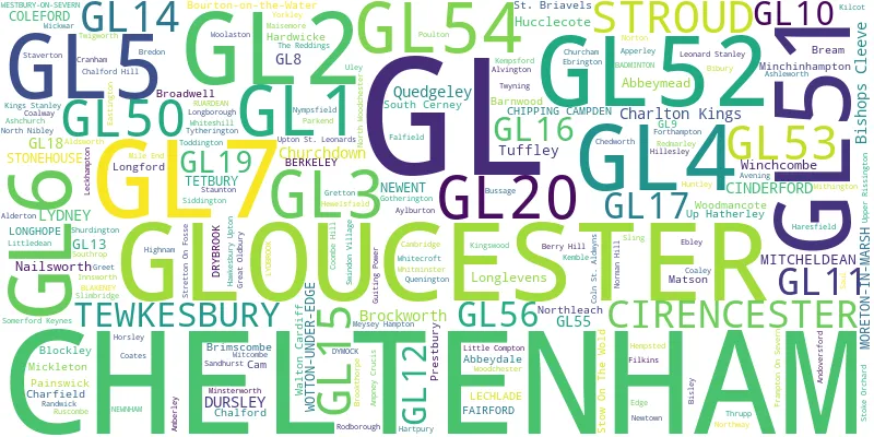
Post Towns and Postcode Districts for the GL Postcode
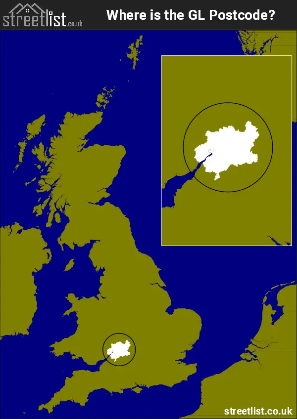
Where is the GL Postcode Area?
The GL Gloucester Postcode is in the South West England. The postal area borders the following neighbouring postal areas: CV - Coventry, WR - Worcester, SN - Swindon, OX - Oxford, NP - Newport, HR - Hereford and BS - Bristol, It also borders The Bristol Channel,
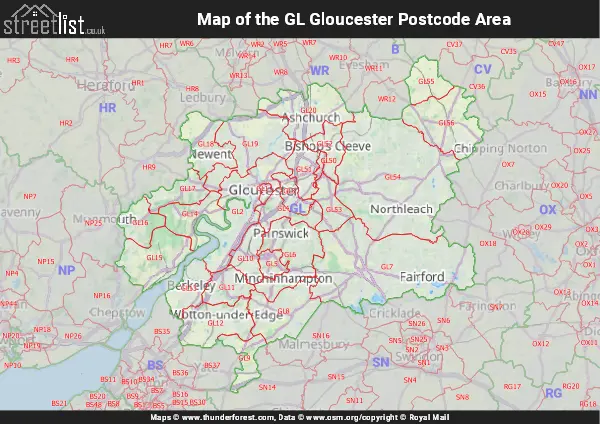
Map of the GL Gloucester Postcode Area
Explore the GL Gloucester postcode area by using our interactive map.
Postcode Districts within the GL Gloucester Postcode Area
There are 27 postcode districts within the Gloucester postcode area
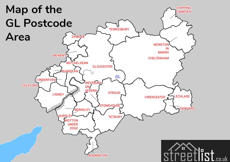
A map showing the boundary of in relation to other areas
There are 22 towns within the Gloucester postcode area.
| Unit | Area² |
|---|---|
| Hectares | 2,799,705² |
| Miles | 10,810² |
| Feet | 301,357,446,495² |
| Kilometres | 27,997² |
Postal Delivery Offices serving the GL Gloucester Postcode Area
- Bourton On The Water Scale Payment Delivery Office
- Cheltenham Delivery Office
- Chipping Campden Delivery Office
- Cinderford Delivery Office
- Cirencester Delivery Office
- Coleford Delivery Office
- Dursley Delivery Office
- Fairford Scale Payment Delivery Office
- Frampton On Severn Scale Payment Delivery Office
- Gloucester Central Delivery Office
- Gloucester North Delivery Office
- Gloucester South Delivery Office
- Lechlade Scale Payment Delivery Office
- Longhope (gl) Scale Payment Delivery Office
- Lydney Delivery Office
- Mitcheldean Scale Payment Delivery Office
- Moreton In Marsh Scale Payment Delivery Office
- Newent Scale Payment Delivery Office
- Northleach Scale Payment Delivery Office
- Stow On The Wold Scale Payment Delivery Office
- Stroud Delivery Office
- Tetbury Delivery Office
- Tewkesbury Delivery Office
- Winchcombe Scale Payment Delivery Office
- Wotton Under Edge Delivery Office
Councils with Postcodes in GL
Towns and Villages within the GL Gloucester Postcode Area
- Ablington - village
- Acton Turville - village
- Adlestrop - village
- Alderton - village
- Aldsworth - village
- Alvington - village
- Amberley - village
- Ampney Crucis - village
- Ampney St Mary - village
- Ampney St Peter - village
- Andoversford - village
- Apperley - village
- Arlingham - village
- Arlington - village
- Ashchurch - village
- Ashleworth - village
- Ashmead Green - village
- Aston Cross - village
- Aston Magna - village
- Avening - village
- Awre - village
- Aylburton - village
- Ayleford - village
- Badminton - village
- Bagpath - village
- Bamfurlong - village
- Barnsley - village
- Barton-on-the-Heath - village
- Baunton - village
- Beckford - village
- Berkeley - village
- Berkeley Heath - village
- Berry Hill - village
- Bibstone - village
- Bibury - village
- Birdlip - village
- Birdwood - village
- Bishop's Cleeve - village
- Bisley - village
- Blaisdon - village
- Blakeney - village
- Bledisloe - otherSettlement
- Blockley - village
- Botloe's Green - village
- Bourton-on-the-Hill - village
- Bourton-on-the-Water - village
- Bownham - village
- Box - village
- Bream - village
- Bredon - village
- Bredon's Norton - village
- Brierley - village
- Brimscombe - village
- Broad Campden - village
- Broadoak - village
- Broadwell - village
- Broadwell - village
- Brockhampton - village
- Brockworth - village
- Brookend - village
- Brookthorpe - village
- Bushley - village
- Bushley Green - village
- Butterrow - village
- Cam - village
- Cambridge - village
- Cerney Wick - village
- Chalford - village
- Charfield - village
- Chedworth - village
- Cheltenham - town
- Chipping Campden - town
- Churcham - village
- Churchdown - village
- Churchend - village
- Cinderford - town
- Cirencester - town
- Clearwell - village
- Cleeve Hill - village
- Clifford's Mesne - village
- Coaley - village
- Coalway - village
- Coates - village
- Coberley - village
- Cold Aston - village
- Coleford - town
- Coln St Aldwyns - village
- Compton Abdale - village
- Conderton - village
- Coombe - village
- Coombe Hill - village
- Corse - village
- Cowley - village
- Cranham - village
- Daglingworth - village
- Didbrook - village
- Didmarton - village
- Down Ampney - village
- Draycott - village
- Drybrook - village
- Duntisbourne Abbots - village
- Dursley - town
- Dursley Cross - otherSettlement
- Dymock - village
- Eastcombe - village
- Eastington - village
- Eastleach Turville - village
- Ebrington - village
- Edge - village
- Edge End - village
- Edgeworth - village
- Ellwood - village
- Elmstone Hardwicke - village
- Elton - village
- English Bicknor - village
- Evenlode - village
- Ewen - village
- Fairford - town
- Falfield - village
- Far Thrupp - village
- Farleys End - village
- Farmington - village
- Filkins - village
- Forthampton - village
- Frampton Mansell - village
- Frampton on Severn - village
- France Lynch - village
- Frocester - village
- Fromebridge - otherSettlement
- Gloucester - city
- Golden Valley - village
- Gorsley - village
- Gotherington - village
- Great Rissington - village
- Great Wolford - village
- Greet - village
- Gretton - village
- Guiting Power - village
- Halmore - village
- Ham - village
- Hardwicke - village
- Haresfield - village
- Hartpury - village
- Hasfield - otherSettlement
- Hatherop - village
- Hawkesbury Upton - village
- Heath End - village
- Hewelsfield Common - village
- Highnam - village
- Hillesley - village
- Hook Street - village
- Horcott - village
- Horsley - village
- Houndscroft - village
- Huntley - village
- Icomb - village
- Innsworth - village
- Kelmscott - village
- Kemble - village
- Kemerton - village
- Kempley Green - village
- Kempsford - village
- Kilcot - village
- King's Stanley - village
- Kingscote - village
- Kingswood - village
- Kinsham - village
- Langford - village
- Lechlade-on-Thames - town
- Leckhampton Hill - village
- Leighterton - village
- Leonard Stanley - village
- Little Badminton - otherSettlement
- Little Beckford - village
- Little Compton - village
- Little Faringdon - village
- Little London - village
- Little Rissington - village
- Little Shurdington - village
- Little Witcombe - village
- Littledean - village
- Littleworth - village
- Long Newnton - village
- Longborough - village
- Longdon - village
- Longford - village
- Longhope - village
- Longney - village
- Longridge - village
- Lowbands - village
- Lower Apperley - village
- Lower Oddington - village
- Lower Slaughter - village
- Lower Swell - village
- Lower Westmancote - village
- Lydney - town
- Maisemore - village
- Meysey Hampton - village
- Mickleton - village
- Middleyard - village
- Milbury Heath - village
- Mile End - village
- Milkwall - village
- Minsterworth - village
- Mitcheldean - town
- Moreton Valence - village
- Moreton-in-Marsh - town
- Nailsworth - town
- Naunton - village
- New Town - village
- Newent - town
- Newland - village
- Newnham - village
- Newport - village
- North Cerney - village
- North Nibley - village
- Northleach - town
- Northway - village
- Northwood Green - village
- Norton - village
- Nupend - village
- Nympsfield - village
- Oakridge Lynch - village
- Oldcroft - village
- Over - village
- Overbury - village
- Painswick - town
- Pamington - village
- Parkend - village
- Paxford - village
- Pendock - village
- Perrott's Brook - village
- Pitchcombe - village
- Playley Green - village
- Plump Hill - village
- Pope's Hill - village
- Poulton - village
- Prestbury - village
- Preston - village
- Purton - village
- Quedgeley - Settlement
- Quenington - village
- Randwick - village
- Redmarley D'Abitot - village
- Rendcomb - village
- Ripple - village
- Rodley - village
- Rodmarton - village
- Ruardean - village
- Ruardean Woodside - village
- Ruscombe - village
- Ruspidge - village
- Sandhurst - village
- Sapperton - village
- Saul - village
- Selsley - village
- Sharpness - village
- Sheepscombe - village
- Sherborne - village
- Shipton - village
- Shipton Moyne - village
- Shurdington - village
- Shuthonger - village
- Siddington - village
- Slad - village
- Slimbridge - village
- Sling - village
- Somerford Keynes - village
- South Cerney - village
- Southam - village
- Southrop - village
- St Briavels - village
- St Chloe - village
- Stantway - village
- Staunton - village
- Staverton - village
- Stinchcombe - village
- Stoke Orchard - village
- Stone - village
- Stonehouse - town
- Stow-on-the-Wold - town
- Stratton - village
- Stretton-on-Fosse - village
- Stroud - town
- Swindon - village
- Tarlton - village
- Teddington - village
- Temple Guiting - village
- Tetbury - town
- Tewkesbury - town
- The Scarr - village
- Theescombe - village
- Thrupp - village
- Tibberton - village
- Tirley - village
- Toddington - village
- Todenham - village
- Tormarton - village
- Townwell - village
- Tredington - village
- Triangle - village
- Turkdean - village
- Twigworth - village
- Twyning - village
- Tytherington - village
- Uckinghall - village
- Uckington - village
- Uley - village
- Upleadon - village
- Upper Framilode - village
- Upper Oddington - village
- Upper Rissington - village
- Upper Slaughter - village
- Upper Soudley - village
- Upthorpe - village
- Upton St Leonards - village
- Viney Hill - village
- Walham - village
- Wanswell - village
- Westbury-on-Severn - village
- Westmancote - village
- Weston-sub-Edge - village
- Westonbirt - village
- Whelford - village
- Whitecroft - village
- Whiteshill - village
- Whitminster - village
- Whittington - village
- Wickwar - village
- Winchcombe - town
- Winson - village
- Winstone - village
- Withington - village
- Woodchester - village
- Woodford - village
- Woodmancote - village
- Woodmancote - village
- Woolaston - village
- Wotton-under-Edge - town
- Yorkley - village
- Yorkley Slade - village