The GL12 7 postcode sector is within the county of Gloucestershire.
Did you know? According to the 2021 Census, the GL12 7 postcode sector is home to a bustling 6,382 residents!
Given that each sector allows for 400 unique postcode combinations. Letters C, I, K, M, O and V are not allowed in the last two letters of a postcode. With 197 postcodes already in use, this leaves 203 units available.
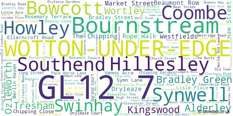
The largest settlement in the GL12 7 postal code is WOTTON-UNDER-EDGE followed by Hillesley, and Coombe.
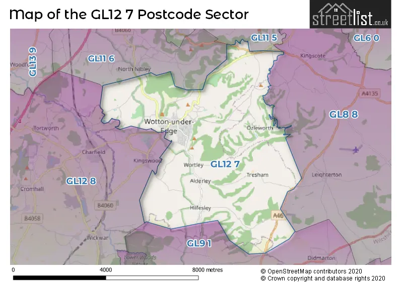
The GL12 7 Postcode shares a border with GL12 8 (Charfield, Wickwar, Kingswood), GL8 8 (TETBURY, Avening, Westonbirt), GL9 1 (Hawkesbury Upton, BADMINTON, Acton Turville), GL11 5 (Cam, Uley, DURSLEY) and GL11 6 (DURSLEY, North Nibley, Stinchcombe).
The sector is within the post town of WOTTON-UNDER-EDGE.
GL12 7 is a postcode sector within the GL12 postcode district which is within the GL Gloucester postcode area.
The Royal Mail delivery office for the GL12 7 postal sector is the Wotton Under Edge Delivery Office.
The area of the GL12 7 postcode sector is 17.70 square miles which is 45.84 square kilometres or 11,326.52 square acres.

Map of the GL12 7 Postcode Sector
Explore the GL12 7 postcode sector by using our free interactive map.
| G | L | 1 | 2 | - | 7 | X | X |
| G | L | 1 | 2 | Space | 7 | Letter | Letter |
Official List of Streets
WOTTON-UNDER-EDGE (80 Streets)
Hillesley (13 Streets)
Coombe (1 Streets)
Howley (2 Streets)
Synwell (4 Streets)
Swinhay (1 Streets)
Unofficial Streets or Alternative Spellings
WOTTON-UNDER-EDGE
DRYLEAZE GARDENS NEW ROAD THE BUTTS WEST VIEWKingswood
HILLESLEY ROAD WOTTON ROADNorth Nibley
WOTTON ROADWeather Forecast for GL12 7
Press Button to Show Forecast for Wotton-Under-Edge
| Time Period | Icon | Description | Temperature | Rain Probability | Wind |
|---|---|---|---|---|---|
| 18:00 to 21:00 | Cloudy | 9.0°C (feels like 7.0°C) | 6.00% | NNE 7 mph | |
| 21:00 to 00:00 | Cloudy | 7.0°C (feels like 5.0°C) | 5.00% | NE 7 mph |
Press Button to Show Forecast for Wotton-Under-Edge
| Time Period | Icon | Description | Temperature | Rain Probability | Wind |
|---|---|---|---|---|---|
| 00:00 to 03:00 | Cloudy | 6.0°C (feels like 4.0°C) | 5.00% | ENE 7 mph | |
| 03:00 to 06:00 | Cloudy | 5.0°C (feels like 3.0°C) | 5.00% | ENE 7 mph | |
| 06:00 to 09:00 | Cloudy | 5.0°C (feels like 2.0°C) | 6.00% | ENE 7 mph | |
| 09:00 to 12:00 | Cloudy | 7.0°C (feels like 5.0°C) | 8.00% | E 9 mph | |
| 12:00 to 15:00 | Overcast | 9.0°C (feels like 8.0°C) | 13.00% | ENE 7 mph | |
| 15:00 to 18:00 | Cloudy | 10.0°C (feels like 8.0°C) | 13.00% | ENE 7 mph | |
| 18:00 to 21:00 | Cloudy | 9.0°C (feels like 8.0°C) | 16.00% | ENE 7 mph | |
| 21:00 to 00:00 | Cloudy | 6.0°C (feels like 4.0°C) | 14.00% | ENE 4 mph |
Press Button to Show Forecast for Wotton-Under-Edge
| Time Period | Icon | Description | Temperature | Rain Probability | Wind |
|---|---|---|---|---|---|
| 00:00 to 03:00 | Cloudy | 5.0°C (feels like 2.0°C) | 14.00% | E 7 mph | |
| 03:00 to 06:00 | Cloudy | 4.0°C (feels like 1.0°C) | 14.00% | ENE 7 mph | |
| 06:00 to 09:00 | Light rain | 4.0°C (feels like 2.0°C) | 48.00% | NE 7 mph | |
| 09:00 to 12:00 | Light rain | 7.0°C (feels like 5.0°C) | 53.00% | ENE 9 mph | |
| 12:00 to 15:00 | Overcast | 9.0°C (feels like 7.0°C) | 22.00% | NE 11 mph | |
| 15:00 to 18:00 | Overcast | 11.0°C (feels like 9.0°C) | 20.00% | ENE 11 mph | |
| 18:00 to 21:00 | Cloudy | 10.0°C (feels like 8.0°C) | 21.00% | NE 11 mph | |
| 21:00 to 00:00 | Light rain | 8.0°C (feels like 5.0°C) | 50.00% | NE 11 mph |
Press Button to Show Forecast for Wotton-Under-Edge
| Time Period | Icon | Description | Temperature | Rain Probability | Wind |
|---|---|---|---|---|---|
| 00:00 to 03:00 | Light rain | 7.0°C (feels like 3.0°C) | 52.00% | NNE 13 mph | |
| 03:00 to 06:00 | Heavy rain | 6.0°C (feels like 3.0°C) | 75.00% | NNE 11 mph | |
| 06:00 to 09:00 | Light rain | 7.0°C (feels like 3.0°C) | 55.00% | N 11 mph | |
| 09:00 to 12:00 | Light rain | 8.0°C (feels like 5.0°C) | 53.00% | NNE 11 mph | |
| 12:00 to 15:00 | Light rain shower (day) | 9.0°C (feels like 6.0°C) | 43.00% | NNW 13 mph | |
| 15:00 to 18:00 | Light rain | 10.0°C (feels like 7.0°C) | 52.00% | NW 11 mph | |
| 18:00 to 21:00 | Light rain shower (day) | 10.0°C (feels like 8.0°C) | 33.00% | N 9 mph | |
| 21:00 to 00:00 | Partly cloudy (night) | 7.0°C (feels like 6.0°C) | 4.00% | NNW 4 mph |
Schools and Places of Education Within the GL12 7 Postcode Sector
Blue Coat CofE Primary School
Voluntary aided school
Symn Lane, Wotton-under-Edge, Gloucestershire, GL12 7BD
Head: Mr Glyn Jones
Ofsted Rating: Good
Inspection: 2023-03-29 (393 days ago)
Website: Visit Blue Coat CofE Primary School Website
Phone: 01453525020
Number of Pupils: 315
Hillesley Church of England Primary School
Voluntary aided school
Kilcot Road, Wotton-under-Edge, Gloucestershire, GL12 7RH
Head: Mrs Lucy Chandler
Ofsted Rating: Good
Inspection: 2018-07-17 (2109 days ago)
Website: Visit Hillesley Church of England Primary School Website
Phone: 01453843551
Number of Pupils: 36
The British School
Foundation school
Wortley Road, Wotton-under-Edge, Gloucestershire, GL12 7JU
Head: Mr Jonathan Roche
Ofsted Rating: Good
Inspection: 2020-03-11 (1506 days ago)
Website: Visit The British School Website
Phone: 01453843371
Number of Pupils: 176
House Prices in the GL12 7 Postcode Sector
| Type of Property | 2018 Average | 2018 Sales | 2017 Average | 2017 Sales | 2016 Average | 2016 Sales | 2015 Average | 2015 Sales |
|---|---|---|---|---|---|---|---|---|
| Detached | £480,880 | 25 | £561,390 | 26 | £400,815 | 29 | £334,522 | 29 |
| Semi-Detached | £286,667 | 18 | £292,009 | 27 | £284,500 | 36 | £265,268 | 31 |
| Terraced | £242,911 | 17 | £237,628 | 32 | £246,039 | 31 | £226,229 | 51 |
| Flats | £128,000 | 9 | £149,290 | 5 | £141,808 | 13 | £140,643 | 14 |
Important Postcodes GL12 7 in the Postcode Sector
GL12 7BD is the postcode for Blue Coat C E Primary School, Symn Lane, and Wotton-Under-Edge Health Centre, Symn Lane
GL12 7DN is the postcode for Wotton under Edge Town Council, 2 Gloucester Street
GL12 7JU is the postcode for The British School, Wortley Road
GL12 7LS is the postcode for Culverhay Surgery, Culverhay
GL12 7RH is the postcode for Hillesley C of E VA Primary School, Kilcott Road
| The GL12 7 Sector is within these Local Authorities |
|
|---|---|
| The GL12 7 Sector is within these Counties |
|
| The GL12 7 Sector is within these Water Company Areas |
|