The GL16 8 postcode sector stands on the Gloucestershire and Gwent border.
Did you know? According to the 2021 Census, the GL16 8 postcode sector is home to a bustling 6,952 residents!
Given that each sector allows for 400 unique postcode combinations. Letters C, I, K, M, O and V are not allowed in the last two letters of a postcode. With 231 postcodes already in use, this leaves 169 units available.
The largest settlement in the GL16 8 postal code is COLEFORD followed by Sling, and Clearwell.
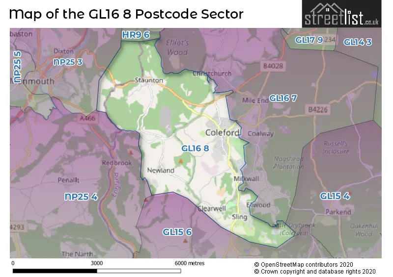
The GL16 8 Postcode shares a border with GL15 4 (BLAKENEY, Yorkley, LYDNEY), GL15 6 (Bream, St. Briavels, Woolaston), GL16 7 (Broadwell, Berry Hill, Coalway), HR9 6 (Whitchurch, Symonds Yat, Goodrich), NP25 4 (DINGESTOW, LLANDOGO, TRELLECH) and NP25 3 (MONMOUTH, WYESHAM, Osbaston).
The sector is within the post town of COLEFORD.
GL16 8 is a postcode sector within the GL16 postcode district which is within the GL Gloucester postcode area.
The Royal Mail delivery office for the GL16 8 postal sector is the Coleford Delivery Office.
The area of the GL16 8 postcode sector is 8.78 square miles which is 22.75 square kilometres or 5,620.64 square acres.

Map of the GL16 8 Postcode Sector
Explore the GL16 8 postcode sector by using our free interactive map.
| G | L | 1 | 6 | - | 8 | X | X |
| G | L | 1 | 6 | Space | 8 | Letter | Letter |
Official List of Streets
COLEFORD (100 Streets)
Newland (3 Streets)
Staunton (7 Streets)
Sling (16 Streets)
Clearwell (10 Streets)
Mushet Industrial Park (2 Streets)
Berry Hill (6 Streets)
Milkwall (3 Streets)
Tufthorn (1 Streets)
Unofficial Streets or Alternative Spellings
Berry Hill
COVERHAM ROAD ARTHUR COOPER WAY CHURCH STREET CINDER HILL CLEARWELL ROAD COLEFORD LINK DUKE OF YORK ROAD FRENCH LANE HALES CLOSE LAUNDRY ROAD MAIN ROAD MARGERY LANE MARYS LANE MILLHILL LANE NEWLAND ROAD OAKLANDS ORCHARD CLOSE PHOENIX COURT RIDGEWAY AVENUE SAINT JOHNS STREET SARNEDY ROAD SHOPHOUSE ROAD ST JOHNS STREET STARLING WAY SUNNY BANK SUNNYBANK ROAD THE CRESCENT VICARAGE COURT WOODLANDS TRAILMONMOUTH
STAUNTON ROADMilkwall
EDENWALL ROAD ELLWOOD ROADCOLEFORD
THE PADDOCKSCoalway
COALWAY ROADMushet Industrial Park
CRUCIBLE COURTSt. Briavels
ROOKERY LANECOLEFORD,
STAUNTON ROADChristchurch
BRUMMELS DRIVEEllwood
MARSH LANEWeather Forecast for GL16 8
Press Button to Show Forecast for Coleford
| Time Period | Icon | Description | Temperature | Rain Probability | Wind |
|---|---|---|---|---|---|
| 06:00 to 09:00 | Overcast | 6.0°C (feels like 5.0°C) | 8.00% | NW 4 mph | |
| 09:00 to 12:00 | Overcast | 8.0°C (feels like 6.0°C) | 7.00% | N 7 mph | |
| 12:00 to 15:00 | Cloudy | 10.0°C (feels like 9.0°C) | 4.00% | N 9 mph | |
| 15:00 to 18:00 | Sunny day | 12.0°C (feels like 10.0°C) | 1.00% | N 9 mph | |
| 18:00 to 21:00 | Sunny day | 10.0°C (feels like 9.0°C) | 1.00% | NNE 7 mph | |
| 21:00 to 00:00 | Clear night | 5.0°C (feels like 4.0°C) | 1.00% | NNE 4 mph |
Press Button to Show Forecast for Coleford
| Time Period | Icon | Description | Temperature | Rain Probability | Wind |
|---|---|---|---|---|---|
| 00:00 to 03:00 | Clear night | 3.0°C (feels like 1.0°C) | 1.00% | NW 4 mph | |
| 03:00 to 06:00 | Clear night | 2.0°C (feels like 0.0°C) | 1.00% | WNW 4 mph | |
| 06:00 to 09:00 | Cloudy | 3.0°C (feels like 1.0°C) | 4.00% | W 4 mph | |
| 09:00 to 12:00 | Cloudy | 9.0°C (feels like 7.0°C) | 5.00% | WNW 7 mph | |
| 12:00 to 15:00 | Overcast | 10.0°C (feels like 9.0°C) | 8.00% | WNW 9 mph | |
| 15:00 to 18:00 | Overcast | 11.0°C (feels like 9.0°C) | 11.00% | NW 9 mph | |
| 18:00 to 21:00 | Cloudy | 10.0°C (feels like 8.0°C) | 7.00% | WNW 7 mph | |
| 21:00 to 00:00 | Cloudy | 7.0°C (feels like 5.0°C) | 6.00% | NNW 4 mph |
Press Button to Show Forecast for Coleford
| Time Period | Icon | Description | Temperature | Rain Probability | Wind |
|---|---|---|---|---|---|
| 00:00 to 03:00 | Cloudy | 5.0°C (feels like 3.0°C) | 10.00% | N 4 mph | |
| 03:00 to 06:00 | Cloudy | 4.0°C (feels like 3.0°C) | 15.00% | N 4 mph | |
| 06:00 to 09:00 | Cloudy | 5.0°C (feels like 3.0°C) | 14.00% | E 4 mph | |
| 09:00 to 12:00 | Cloudy | 7.0°C (feels like 5.0°C) | 14.00% | ESE 7 mph | |
| 12:00 to 15:00 | Overcast | 9.0°C (feels like 7.0°C) | 18.00% | SE 9 mph | |
| 15:00 to 18:00 | Overcast | 9.0°C (feels like 8.0°C) | 20.00% | ESE 9 mph | |
| 18:00 to 21:00 | Cloudy | 9.0°C (feels like 7.0°C) | 18.00% | ENE 7 mph | |
| 21:00 to 00:00 | Cloudy | 7.0°C (feels like 5.0°C) | 19.00% | ENE 7 mph |
Press Button to Show Forecast for Coleford
| Time Period | Icon | Description | Temperature | Rain Probability | Wind |
|---|---|---|---|---|---|
| 00:00 to 03:00 | Light rain | 6.0°C (feels like 4.0°C) | 50.00% | NNE 7 mph | |
| 03:00 to 06:00 | Cloudy | 5.0°C (feels like 3.0°C) | 20.00% | NNE 4 mph | |
| 06:00 to 09:00 | Cloudy | 6.0°C (feels like 4.0°C) | 18.00% | NNE 7 mph | |
| 09:00 to 12:00 | Cloudy | 8.0°C (feels like 6.0°C) | 16.00% | ENE 9 mph | |
| 12:00 to 15:00 | Light rain | 10.0°C (feels like 8.0°C) | 48.00% | E 9 mph | |
| 15:00 to 18:00 | Light rain | 11.0°C (feels like 9.0°C) | 50.00% | E 9 mph | |
| 18:00 to 21:00 | Light rain shower (day) | 10.0°C (feels like 8.0°C) | 37.00% | NNE 7 mph | |
| 21:00 to 00:00 | Overcast | 8.0°C (feels like 6.0°C) | 22.00% | ENE 7 mph |
Schools and Places of Education Within the GL16 8 Postcode Sector
Clearwell Church of England Primary School
Voluntary controlled school
Church Road, Coleford, Gloucestershire, GL16 8LG
Head: Mrs Joanne Jones
Ofsted Rating: Good
Inspection: 2018-12-11 (1961 days ago)
Website: Visit Clearwell Church of England Primary School Website
Phone: 01594834904
Number of Pupils: 56
St John's C of E Academy
Academy converter
Bowens Hill Road, Coleford, Gloucestershire, GL16 8DU
Head: Mrs Joanne Peaper
Ofsted Rating: Good
Inspection: 2022-01-20 (825 days ago)
Website: Visit St John's C of E Academy Website
Phone: 01594832046
Number of Pupils: 158
House Prices in the GL16 8 Postcode Sector
| Type of Property | 2018 Average | 2018 Sales | 2017 Average | 2017 Sales | 2016 Average | 2016 Sales | 2015 Average | 2015 Sales |
|---|---|---|---|---|---|---|---|---|
| Detached | £311,474 | 50 | £278,528 | 81 | £274,881 | 81 | £255,936 | 61 |
| Semi-Detached | £199,847 | 50 | £173,457 | 59 | £154,779 | 55 | £161,970 | 35 |
| Terraced | £172,141 | 17 | £152,733 | 30 | £129,323 | 31 | £122,796 | 15 |
| Flats | £95,393 | 15 | £80,883 | 9 | £96,458 | 12 | £72,575 | 12 |
Important Postcodes GL16 8 in the Postcode Sector
GL16 8BQ is the postcode for 4 Mushet Walk
GL16 8DN is the postcode for 2gether NHS Foundation Trust, Coleford House
GL16 8DU is the postcode for St. Johns School, Bowens Hill Road
GL16 8HG is the postcode for Forest of Dean District Council, Council Offices, High Street, and Council Office, High Street
GL16 8HQ is the postcode for Gloucestershire Fire & Rescue Service, Fire Station, Cinderhill
GL16 8LG is the postcode for Clearwell C E School, Church Road
GL16 8RH is the postcode for Coleford Health Centre, Railway Drive, Coleford Community Centre, Old Station Way, Coleford Enterprise Centre, The Main Place, and Gloucestershire County Council, The Main Place, Railway Drive
| The GL16 8 Sector is within these Local Authorities |
|
|---|---|
| The GL16 8 Sector is within these Counties |
|
| The GL16 8 Sector is within these Water Company Areas |
|
Tourist Attractions within the GL16 8 Postcode Area
We found 1 visitor attractions within the GL16 postcode area
| Clearwell Caves |
|---|
| Workplace |
| Industrial / Craft Workplace |
| View Clearwell Caves on Google Maps |