The GL51 7 postcode sector is within the county of Gloucestershire.
Did you know? According to the 2021 Census, the GL51 7 postcode sector is home to a bustling 7,031 residents!
Given that each sector allows for 400 unique postcode combinations. Letters C, I, K, M, O and V are not allowed in the last two letters of a postcode. With 238 postcodes already in use, this leaves 162 units available.
The largest settlements in the GL51 7 postal code are CHELTENHAM and St. Marks.
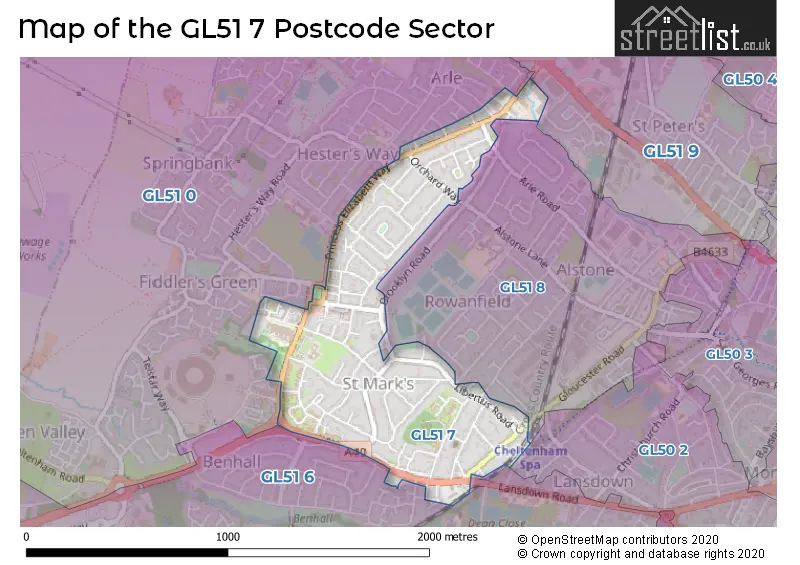
The GL51 7 Postcode shares a border with GL51 0 (CHELTENHAM, Staverton, Hayden), GL51 6 (CHELTENHAM, The Reddings, Staverton), GL51 9 (CHELTENHAM, Swindon Village, Uckington), GL50 2 (CHELTENHAM) and GL51 8 (CHELTENHAM, Cheltenham Trade Park).
The sector is within the post town of CHELTENHAM.
GL51 7 is a postcode sector within the GL51 postcode district which is within the GL Gloucester postcode area.
The Royal Mail delivery office for the GL51 7 postal sector is the Cheltenham Delivery Office.
The area of the GL51 7 postcode sector is 0.46 square miles which is 1.19 square kilometres or 295.17 square acres.

Map of the GL51 7 Postcode Sector
Explore the GL51 7 postcode sector by using our free interactive map.
| G | L | 5 | 1 | - | 7 | X | X |
| G | L | 5 | 1 | Space | 7 | Letter | Letter |
Official List of Streets
CHELTENHAM (68 Streets)
Unofficial Streets or Alternative Spellings
CHELTENHAM
ARLE ROAD BENHALL AVENUE BROOKLYN CLOSE DEVON AVENUE DORMER ROAD FRANK BROOKES ROAD GEORGE READINGS WAY GRANLEY GARDENS GRANLEY ROAD HITCHLANDS DRIVE KINGSMEAD AVENUE KINGSMEAD ROAD LANSDOWN ROAD LECHMERE ROAD OLDBURY ROAD PINEWOOD DRIVE REDGROVE ROAD ROWANFIELD ROAD BENHALL GARDENS BENHALL ROUNDABOUT CASTLE MEWS CHELTENHAM SARACENS RFC CORONATION SQUARE EVINGTON ROAD FAIRMOUNT COURT FRAMLINGTON COURT GIFFORD COURT HESTERS WAY ROAD LIBERTUS PLACE MONKS CROFT TANNERS LANEStaverton
GLOUCESTER ROADSchools and Places of Education Within the GL51 7 Postcode Sector
Gloucestershire College
Further education
Cheltenham Campus, Cheltenham, Gloucestershire, GL51 7SJ
Head: Mr Matthew Burgess
Ofsted Rating: Good
Inspection: 2022-11-11 (531 days ago)
Website: Visit Gloucestershire College Website
Phone: 01452563451
Number of Pupils: 0
House Prices in the GL51 7 Postcode Sector
| Type of Property | 2018 Average | 2018 Sales | 2017 Average | 2017 Sales | 2016 Average | 2016 Sales | 2015 Average | 2015 Sales |
|---|---|---|---|---|---|---|---|---|
| Detached | £343,375 | 4 | £354,000 | 2 | £485,714 | 7 | £349,809 | 6 |
| Semi-Detached | £226,074 | 40 | £247,544 | 37 | £239,256 | 50 | £244,610 | 31 |
| Terraced | £254,031 | 16 | £218,053 | 18 | £179,291 | 17 | £216,267 | 15 |
| Flats | £112,575 | 40 | £116,038 | 39 | £119,263 | 58 | £120,986 | 37 |
Important Postcodes GL51 7 in the Postcode Sector
GL51 7RT is the postcode for Gloucestershire County Council, Hesters Way Library, Goldsmith Road
GL51 7SA is the postcode for Gloucestershire County Council, 28-30 Edinburgh Place, Coronation Square
GL51 7SJ is the postcode for Gloucestershire College, Cheltenham Campus
GL51 7SU is the postcode for Hesters Way Neighbourhood Project, Hesters Way Community Resource Centre, Cassin Drive, and Hesters Way Community Resource Centre, Cassin Drive
| The GL51 7 Sector is within these Local Authorities |
|
|---|---|
| The GL51 7 Sector is within these Counties |
|
| The GL51 7 Sector is within these Water Company Areas |
|