The HA2 7 postcode sector is within the county of Greater London.
Did you know? According to the 2021 Census, the HA2 7 postcode sector is home to a bustling 8,564 residents!
Given that each sector allows for 400 unique postcode combinations. Letters C, I, K, M, O and V are not allowed in the last two letters of a postcode. With 148 postcodes already in use, this leaves 252 units available.
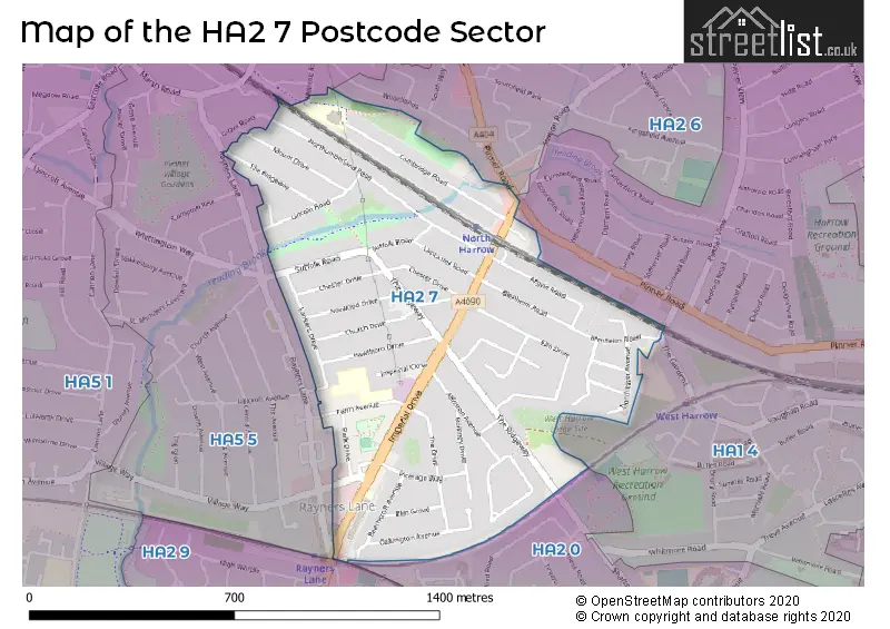
The largest settlement in the HA2 7 postal code is HARROW followed by NORTH HARROW , and RAYNERS LANE .
The HA2 7 Postcode shares a border with HA1 4 (HARROW , WEST HARROW , WEALDSTONE ), HA2 6 (HARROW , NORTH HARROW , HARROW WEALD ), HA2 0 (HARROW , SOUTH HARROW , RAYNERS LANE ), HA2 9 (HARROW , RAYNERS LANE , SOUTH HARROW ) and HA5 5 (PINNER , HARROW , RAYNERS LANE ).
The sector is within the post town of HARROW.
HA2 7 is a postcode sector within the HA2 postcode district which is within the HA Harrow postcode area.
The Royal Mail delivery office for the HA2 7 postal sector is the Harrow Central Delivery Office and Harrow North & South Delivery Office.
The area of the HA2 7 postcode sector is 0.52 square miles which is 1.36 square kilometres or 335.02 square acres.
Waterways within the HA2 7 postcode sector include the Yeading Brook.

Map of the HA2 7 Postcode Sector
Explore the HA2 7 postcode sector by using our free interactive map.
| H | A | 2 | - | 7 | X | X |
| H | A | 2 | Space | 7 | Letter | Letter |
Official List of Streets
HARROW (39 Streets)
Unofficial Streets or Alternative Spellings
HARROW
ALEXANDRA AVENUE THE GARDENS IMPERIAL COURT ULLSWATER COURT YEADING WALKPINNER
MELROSE ROADHARROW,
PINNER ROAD RAYNERS LANEWeather Forecast for HA2 7
Press Button to Show Forecast for Harrow
| Time Period | Icon | Description | Temperature | Rain Probability | Wind |
|---|---|---|---|---|---|
| 15:00 to 18:00 | Heavy rain | 11.0°C (feels like 8.0°C) | 65.00% | NW 11 mph | |
| 18:00 to 21:00 | Heavy rain | 8.0°C (feels like 6.0°C) | 77.00% | NNW 7 mph | |
| 21:00 to 00:00 | Cloudy | 7.0°C (feels like 5.0°C) | 13.00% | NW 7 mph |
Press Button to Show Forecast for Harrow
| Time Period | Icon | Description | Temperature | Rain Probability | Wind |
|---|---|---|---|---|---|
| 00:00 to 03:00 | Cloudy | 6.0°C (feels like 4.0°C) | 4.00% | NW 7 mph | |
| 03:00 to 06:00 | Partly cloudy (night) | 5.0°C (feels like 2.0°C) | 4.00% | WNW 9 mph | |
| 06:00 to 09:00 | Partly cloudy (day) | 5.0°C (feels like 1.0°C) | 1.00% | NW 11 mph | |
| 09:00 to 12:00 | Cloudy | 7.0°C (feels like 4.0°C) | 8.00% | NW 13 mph | |
| 12:00 to 15:00 | Partly cloudy (day) | 11.0°C (feels like 8.0°C) | 3.00% | NW 13 mph | |
| 15:00 to 18:00 | Cloudy | 11.0°C (feels like 8.0°C) | 11.00% | NNW 11 mph | |
| 18:00 to 21:00 | Cloudy | 9.0°C (feels like 6.0°C) | 15.00% | NW 9 mph | |
| 21:00 to 00:00 | Clear night | 7.0°C (feels like 4.0°C) | 3.00% | NW 9 mph |
Press Button to Show Forecast for Harrow
| Time Period | Icon | Description | Temperature | Rain Probability | Wind |
|---|---|---|---|---|---|
| 00:00 to 03:00 | Cloudy | 5.0°C (feels like 2.0°C) | 5.00% | NNW 9 mph | |
| 03:00 to 06:00 | Partly cloudy (night) | 5.0°C (feels like 2.0°C) | 1.00% | N 9 mph | |
| 06:00 to 09:00 | Partly cloudy (day) | 4.0°C (feels like 2.0°C) | 2.00% | N 7 mph | |
| 09:00 to 12:00 | Cloudy | 8.0°C (feels like 7.0°C) | 5.00% | N 7 mph | |
| 12:00 to 15:00 | Cloudy | 11.0°C (feels like 10.0°C) | 5.00% | W 4 mph | |
| 15:00 to 18:00 | Cloudy | 12.0°C (feels like 11.0°C) | 5.00% | W 9 mph | |
| 18:00 to 21:00 | Cloudy | 12.0°C (feels like 10.0°C) | 8.00% | W 9 mph | |
| 21:00 to 00:00 | Overcast | 10.0°C (feels like 7.0°C) | 13.00% | W 11 mph |
Press Button to Show Forecast for Harrow
| Time Period | Icon | Description | Temperature | Rain Probability | Wind |
|---|---|---|---|---|---|
| 00:00 to 03:00 | Light rain | 8.0°C (feels like 5.0°C) | 53.00% | WSW 11 mph | |
| 03:00 to 06:00 | Cloudy | 8.0°C (feels like 5.0°C) | 13.00% | W 11 mph | |
| 06:00 to 09:00 | Cloudy | 9.0°C (feels like 6.0°C) | 15.00% | W 11 mph | |
| 09:00 to 12:00 | Cloudy | 10.0°C (feels like 7.0°C) | 5.00% | NW 13 mph | |
| 12:00 to 15:00 | Overcast | 12.0°C (feels like 9.0°C) | 10.00% | NW 16 mph | |
| 15:00 to 18:00 | Light rain | 13.0°C (feels like 10.0°C) | 50.00% | NNW 13 mph | |
| 18:00 to 21:00 | Partly cloudy (day) | 11.0°C (feels like 9.0°C) | 2.00% | NNW 11 mph | |
| 21:00 to 00:00 | Partly cloudy (night) | 9.0°C (feels like 7.0°C) | 2.00% | N 9 mph |
Press Button to Show Forecast for Harrow
| Time Period | Icon | Description | Temperature | Rain Probability | Wind |
|---|---|---|---|---|---|
| 00:00 to 03:00 | Clear night | 7.0°C (feels like 5.0°C) | 2.00% | N 9 mph | |
| 03:00 to 06:00 | Clear night | 6.0°C (feels like 3.0°C) | 1.00% | NNW 9 mph | |
| 06:00 to 09:00 | Partly cloudy (day) | 6.0°C (feels like 3.0°C) | 1.00% | NNW 7 mph | |
| 09:00 to 12:00 | Partly cloudy (day) | 9.0°C (feels like 6.0°C) | 1.00% | N 9 mph | |
| 12:00 to 15:00 | Overcast | 11.0°C (feels like 9.0°C) | 7.00% | N 9 mph | |
| 15:00 to 18:00 | Cloudy | 12.0°C (feels like 11.0°C) | 4.00% | N 9 mph | |
| 18:00 to 21:00 | Partly cloudy (day) | 12.0°C (feels like 10.0°C) | 2.00% | N 7 mph | |
| 21:00 to 00:00 | Clear night | 9.0°C (feels like 8.0°C) | 1.00% | N 4 mph |
Schools and Places of Education Within the HA2 7 Postcode Sector
Longfield Primary School
Community school
Duke's Avenue, Harrow, Middlesex, HA2 7NZ
Head: Mrs Pam Virdee
Ofsted Rating: Good
Inspection: 2023-07-19 (272 days ago)
Website: Visit Longfield Primary School Website
Phone: 02088667331
Number of Pupils: 754
House Prices in the HA2 7 Postcode Sector
| Type of Property | 2018 Average | 2018 Sales | 2017 Average | 2017 Sales | 2016 Average | 2016 Sales | 2015 Average | 2015 Sales |
|---|---|---|---|---|---|---|---|---|
| Detached | £673,143 | 7 | £636,079 | 12 | £672,125 | 8 | £583,000 | 6 |
| Semi-Detached | £613,306 | 26 | £596,449 | 31 | £593,694 | 31 | £528,555 | 44 |
| Terraced | £551,958 | 12 | £618,091 | 16 | £603,300 | 10 | £518,215 | 23 |
| Flats | £279,517 | 24 | £279,464 | 14 | £260,311 | 27 | £260,167 | 15 |
Important Postcodes HA2 7 in the Postcode Sector
HA2 7HJ is the postcode for London Borough of Harrow, Rayners Lane Library, Imperial Drive
HA2 7NZ is the postcode for Longfield School, Dukes Avenue
| The HA2 7 Sector is within these Local Authorities |
|
|---|---|
| The HA2 7 Sector is within these Counties |
|
| The HA2 7 Sector is within these Water Company Areas |
|