The HA2 9 postcode sector is within the county of Greater London.
Did you know? According to the 2021 Census, the HA2 9 postcode sector is home to a bustling 15,491 residents!
Given that each sector allows for 400 unique postcode combinations. Letters C, I, K, M, O and V are not allowed in the last two letters of a postcode. With 206 postcodes already in use, this leaves 194 units available.
The largest settlement in the HA2 9 postal code is HARROW followed by RAYNERS LANE , and SOUTH HARROW .
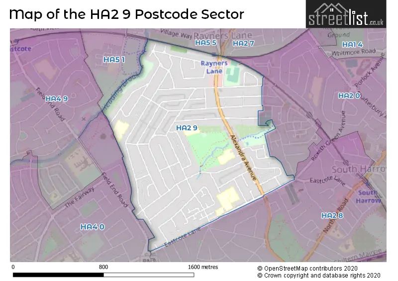
The HA2 9 Postcode shares a border with HA4 0 (RUISLIP ), HA2 0 (HARROW , SOUTH HARROW , RAYNERS LANE ), HA2 7 (HARROW , NORTH HARROW , RAYNERS LANE ), HA2 8 (HARROW , SOUTH HARROW ), HA5 1 (PINNER , EASTCOTE , RUISLIP ) and HA5 5 (PINNER , HARROW , RAYNERS LANE ).
The sector is within the post town of HARROW.
HA2 9 is a postcode sector within the HA2 postcode district which is within the HA Harrow postcode area.
The Royal Mail delivery office for the HA2 9 postal sector is the Harrow Central Delivery Office and Harrow North & South Delivery Office.
The area of the HA2 9 postcode sector is 0.74 square miles which is 1.92 square kilometres or 475.17 square acres.
Waterways within the HA2 9 postcode sector include the Yeading Brook.

Map of the HA2 9 Postcode Sector
Explore the HA2 9 postcode sector by using our free interactive map.
| H | A | 2 | - | 9 | X | X |
| H | A | 2 | Space | 9 | Letter | Letter |
Official List of Streets
HARROW (56 Streets)
South Harrow (1 Streets)
Unofficial Streets or Alternative Spellings
HARROW
IVY CLOSE KARMA WAY KENILWORTH AVENUE PARK LANE BODMIN CLOSE CLOVELLY WAY CROSS ROAD WIDDICOMBE AVENUEHARROW,
RAYNERS LANEPINNER,
FIELD END ROADWeather Forecast for HA2 9
Press Button to Show Forecast for Harrow
| Time Period | Icon | Description | Temperature | Rain Probability | Wind |
|---|---|---|---|---|---|
| 21:00 to 00:00 | Cloudy | 7.0°C (feels like 5.0°C) | 7.00% | ENE 7 mph |
Press Button to Show Forecast for Harrow
| Time Period | Icon | Description | Temperature | Rain Probability | Wind |
|---|---|---|---|---|---|
| 00:00 to 03:00 | Cloudy | 6.0°C (feels like 4.0°C) | 5.00% | ENE 7 mph | |
| 03:00 to 06:00 | Cloudy | 5.0°C (feels like 3.0°C) | 5.00% | NE 7 mph | |
| 06:00 to 09:00 | Cloudy | 4.0°C (feels like 2.0°C) | 5.00% | NE 7 mph | |
| 09:00 to 12:00 | Partly cloudy (day) | 8.0°C (feels like 5.0°C) | 2.00% | ENE 9 mph | |
| 12:00 to 15:00 | Cloudy | 10.0°C (feels like 9.0°C) | 10.00% | E 7 mph | |
| 15:00 to 18:00 | Overcast | 11.0°C (feels like 9.0°C) | 14.00% | ENE 7 mph | |
| 18:00 to 21:00 | Cloudy | 10.0°C (feels like 9.0°C) | 13.00% | NE 7 mph | |
| 21:00 to 00:00 | Cloudy | 7.0°C (feels like 5.0°C) | 12.00% | E 7 mph |
Press Button to Show Forecast for Harrow
| Time Period | Icon | Description | Temperature | Rain Probability | Wind |
|---|---|---|---|---|---|
| 00:00 to 03:00 | Cloudy | 5.0°C (feels like 3.0°C) | 11.00% | ENE 7 mph | |
| 03:00 to 06:00 | Cloudy | 5.0°C (feels like 2.0°C) | 18.00% | NE 7 mph | |
| 06:00 to 09:00 | Cloudy | 5.0°C (feels like 3.0°C) | 22.00% | NE 9 mph | |
| 09:00 to 12:00 | Cloudy | 9.0°C (feels like 7.0°C) | 17.00% | ENE 9 mph | |
| 12:00 to 15:00 | Overcast | 12.0°C (feels like 9.0°C) | 18.00% | E 9 mph | |
| 15:00 to 18:00 | Overcast | 12.0°C (feels like 10.0°C) | 22.00% | E 11 mph | |
| 18:00 to 21:00 | Light rain | 11.0°C (feels like 9.0°C) | 53.00% | ENE 11 mph | |
| 21:00 to 00:00 | Light rain | 9.0°C (feels like 7.0°C) | 53.00% | NE 11 mph |
Press Button to Show Forecast for Harrow
| Time Period | Icon | Description | Temperature | Rain Probability | Wind |
|---|---|---|---|---|---|
| 00:00 to 03:00 | Heavy rain | 9.0°C (feels like 6.0°C) | 74.00% | NE 9 mph | |
| 03:00 to 06:00 | Heavy rain shower (night) | 9.0°C (feels like 7.0°C) | 60.00% | ESE 9 mph | |
| 06:00 to 09:00 | Light rain | 9.0°C (feels like 7.0°C) | 54.00% | ESE 7 mph | |
| 09:00 to 12:00 | Heavy rain | 10.0°C (feels like 8.0°C) | 77.00% | SE 9 mph | |
| 12:00 to 15:00 | Light rain | 12.0°C (feels like 10.0°C) | 56.00% | SSE 9 mph | |
| 15:00 to 18:00 | Heavy rain shower (day) | 13.0°C (feels like 11.0°C) | 56.00% | SSW 11 mph | |
| 18:00 to 21:00 | Partly cloudy (day) | 12.0°C (feels like 9.0°C) | 15.00% | WSW 11 mph | |
| 21:00 to 00:00 | Cloudy | 10.0°C (feels like 8.0°C) | 8.00% | SW 7 mph |
Schools and Places of Education Within the HA2 9 Postcode Sector
Alexandra School
Academy special converter
Alexandra Avenue, Harrow, , HA2 9DX
Head: Mrs Perdy Buchanan-Barrow
Ofsted Rating: Outstanding
Inspection: 2019-11-07 (1631 days ago)
Website: Visit Alexandra School Website
Phone: 02088642739
Number of Pupils: 80
Heathland School
Academy converter
Eastcote Lane, Harrow, Middlesex, HA2 9AG
Head: Ms Fiona Hopkins
Ofsted Rating: Good
Inspection: 2023-09-27 (211 days ago)
Website: Visit Heathland School Website
Phone: 02084224503
Number of Pupils: 659
Newton Farm Nursery, Infant and Junior School
Community school
Ravenswood Crescent, Harrow, Middlesex, HA2 9JU
Head: Mr Matthew Bradley
Ofsted Rating: Good
Inspection: 2022-09-15 (588 days ago)
Website: Visit Newton Farm Nursery, Infant and Junior School Website
Phone: 02088648081
Number of Pupils: 455
Rooks Heath School
Academy converter
Eastcote Lane, Harrow, , HA2 9AH
Head: Mrs Miriam Manderson
Ofsted Rating: Good
Inspection: 2019-01-30 (1912 days ago)
Website: Visit Rooks Heath School Website
Phone: 02084224675
Number of Pupils: 1177
Roxbourne Primary School
Community school
Torbay Road, Harrow, , HA2 9QF
Head: Mr R Benserghin
Ofsted Rating: Good
Inspection: 2020-02-12 (1534 days ago)
Website: Visit Roxbourne Primary School Website
Phone: 02084229207
Number of Pupils: 465
House Prices in the HA2 9 Postcode Sector
| Type of Property | 2018 Average | 2018 Sales | 2017 Average | 2017 Sales | 2016 Average | 2016 Sales | 2015 Average | 2015 Sales |
|---|---|---|---|---|---|---|---|---|
| Detached | £0 | 0 | £464,999 | 1 | £695,000 | 2 | £0 | 0 |
| Semi-Detached | £479,184 | 19 | £523,545 | 11 | £528,767 | 15 | £483,538 | 26 |
| Terraced | £481,042 | 53 | £474,699 | 75 | £476,351 | 70 | £422,973 | 84 |
| Flats | £277,445 | 19 | £280,068 | 33 | £273,515 | 30 | £235,198 | 32 |
Important Postcodes HA2 9 in the Postcode Sector
HA2 9AG is the postcode for ROOKS HEATH COLLEGE FOR BUSINESS & ENTERPRISE, Heathlands School, Eastcote Lane, Rooks Heath College for Business & Enterprise, Eastcote Lane, and Heathlands School, Eastcote Lane
HA2 9AH is the postcode for Rooks Heath College, Eastcote Lane
HA2 9BD is the postcode for Meadfield House, Kings Road
HA2 9DX is the postcode for Alexandra Avenue Health & Social Care Centre, 275 Alexandra Avenue, Alexandra Avenue School, Alexandra Avenue, and Alexandra School, Alexandra Avenue
HA2 9JU is the postcode for Newton Farm First & Middle School, Ravenswood Crescent
HA2 9JY is the postcode for Cornell House, Hamilton Crescent
HA2 9QF is the postcode for Roxbourne First School, Torbay Road
| The HA2 9 Sector is within these Local Authorities |
|
|---|---|
| The HA2 9 Sector is within these Counties |
|
| The HA2 9 Sector is within these Water Company Areas |
|