The HA4 postcode district is a postal district located in the HA Harrow postcode area with a population of 53,095 residents according to the 2021 England and Wales Census.
The area of the HA4 postcode district is 6.11 square miles which is 15.81 square kilometres or 3,907.34 acres.
Currently, the HA4 district has about 1151 postcode units spread across 5 geographic postcode sectors.
Given that each sector allows for 400 unique postcode combinations, the district has a capacity of 2,000 postcodes. With 1151 postcodes already in use, this leaves 849 units available.
The HA4 postal code covers the settlement of RUISLIP.
The HA4 Postcode shares a border with HA5 (PINNER, EASTCOTE), HA2 (HARROW, SOUTH HARROW) and UB5 (NORTHOLT).
The primary settlement in the HA4 postcode district is Ruislip, located in Greater London. Other significant settlements in the district include South Ruislip. The county of Greater London encompasses this postcode district. The most significant post town in the district is Ruislip.
For the district HA4, we have data on 6 postcode sectors. Here's a breakdown: The sector HA4 0, covers Ruislip in Greater London. The sector HA4 4 is non-geographic. It's often designated for PO Boxes, large organisations, or special services. The sector HA4 6, covers Ruislip in Greater London. The sector HA4 7, covers Ruislip in Greater London. The sector HA4 8, covers Ruislip in Greater London. The sector HA4 9, covers Ruislip in Greater London.

Map of the HA4 Postcode District
Explore the HA4 postcode district by using our free interactive map.
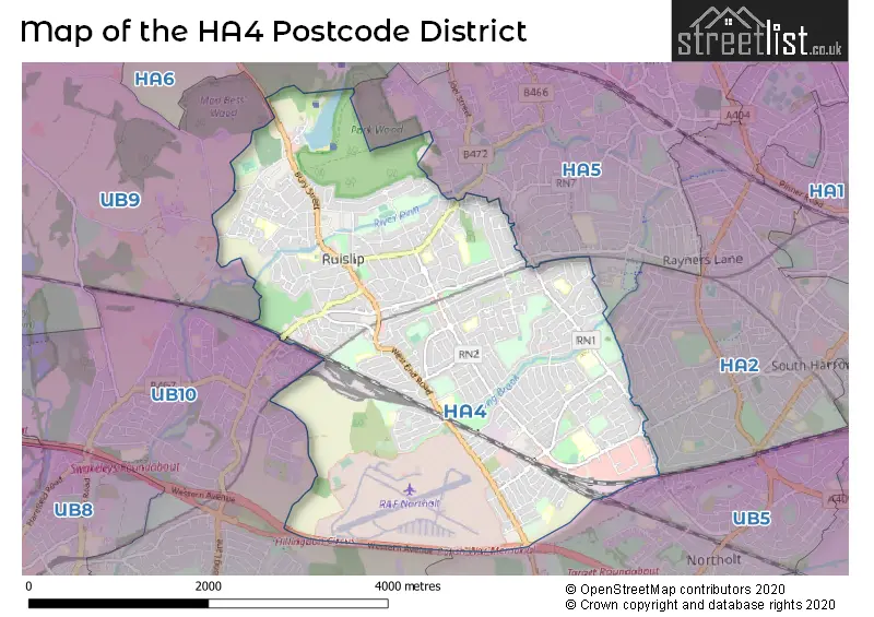
When it comes to local government, postal geography often disregards political borders. However, for a breakdown in the HA4 District: the district mostly encompasses the Hillingdon London Boro (1142 postcodes), and finally, the Harrow London Boro area (4 postcodes).
Recent House Sales in HA4
| Date | Price | Address |
|---|---|---|
| 18/10/2023 | £285,000 | Victoria Road, Ruislip, HA4 9AA |
| 18/10/2023 | £240,000 | Park Way, Ruislip, HA4 8NS |
| 18/10/2023 | £300,000 | Victoria Road, Ruislip, HA4 9AA |
| 18/10/2023 | £240,000 | Park Way, Ruislip, HA4 8NS |
| 18/10/2023 | £285,000 | Victoria Road, Ruislip, HA4 9AA |
| 18/10/2023 | £275,000 | Park Way, Ruislip, HA4 8NS |
| 18/10/2023 | £300,000 | Victoria Road, Ruislip, HA4 9AA |
| 18/10/2023 | £285,000 | Park Way, Ruislip, HA4 8NS |
| 18/10/2023 | £275,000 | Victoria Road, Ruislip, HA4 9AA |
| 06/10/2023 | £534,400 | Hartland Drive, Ruislip, HA4 0TJ |
Weather Forecast for HA4
Press Button to Show Forecast for Northolt
| Time Period | Icon | Description | Temperature | Rain Probability | Wind |
|---|---|---|---|---|---|
| 00:00 to 03:00 | Cloudy | 7.0°C (feels like 4.0°C) | 5.00% | ENE 7 mph | |
| 03:00 to 06:00 | Cloudy | 5.0°C (feels like 3.0°C) | 5.00% | NE 7 mph | |
| 06:00 to 09:00 | Cloudy | 5.0°C (feels like 2.0°C) | 5.00% | NE 7 mph | |
| 09:00 to 12:00 | Cloudy | 8.0°C (feels like 6.0°C) | 5.00% | ENE 9 mph | |
| 12:00 to 15:00 | Cloudy | 11.0°C (feels like 10.0°C) | 8.00% | E 9 mph | |
| 15:00 to 18:00 | Overcast | 11.0°C (feels like 10.0°C) | 16.00% | ENE 9 mph | |
| 18:00 to 21:00 | Cloudy | 11.0°C (feels like 10.0°C) | 13.00% | NE 7 mph | |
| 21:00 to 00:00 | Cloudy | 8.0°C (feels like 5.0°C) | 12.00% | E 7 mph |
Press Button to Show Forecast for Northolt
| Time Period | Icon | Description | Temperature | Rain Probability | Wind |
|---|---|---|---|---|---|
| 00:00 to 03:00 | Cloudy | 6.0°C (feels like 4.0°C) | 17.00% | ENE 4 mph | |
| 03:00 to 06:00 | Light rain | 5.0°C (feels like 3.0°C) | 47.00% | NE 7 mph | |
| 06:00 to 09:00 | Cloudy | 6.0°C (feels like 3.0°C) | 22.00% | NE 7 mph | |
| 09:00 to 12:00 | Cloudy | 9.0°C (feels like 7.0°C) | 16.00% | ENE 9 mph | |
| 12:00 to 15:00 | Overcast | 12.0°C (feels like 10.0°C) | 17.00% | E 11 mph | |
| 15:00 to 18:00 | Overcast | 13.0°C (feels like 11.0°C) | 23.00% | ENE 13 mph | |
| 18:00 to 21:00 | Light rain | 11.0°C (feels like 9.0°C) | 53.00% | ENE 11 mph | |
| 21:00 to 00:00 | Light rain | 10.0°C (feels like 7.0°C) | 54.00% | NE 11 mph |
Press Button to Show Forecast for Northolt
| Time Period | Icon | Description | Temperature | Rain Probability | Wind |
|---|---|---|---|---|---|
| 00:00 to 03:00 | Heavy rain | 9.0°C (feels like 7.0°C) | 71.00% | NE 9 mph | |
| 03:00 to 06:00 | Heavy rain | 9.0°C (feels like 7.0°C) | 76.00% | ENE 7 mph | |
| 06:00 to 09:00 | Light rain | 9.0°C (feels like 8.0°C) | 52.00% | ESE 7 mph | |
| 09:00 to 12:00 | Heavy rain | 11.0°C (feels like 9.0°C) | 76.00% | ESE 9 mph | |
| 12:00 to 15:00 | Light rain shower (day) | 13.0°C (feels like 11.0°C) | 44.00% | SSE 11 mph | |
| 15:00 to 18:00 | Light rain shower (day) | 14.0°C (feels like 12.0°C) | 39.00% | WSW 13 mph | |
| 18:00 to 21:00 | Light rain shower (day) | 12.0°C (feels like 10.0°C) | 34.00% | WSW 11 mph | |
| 21:00 to 00:00 | Cloudy | 10.0°C (feels like 9.0°C) | 11.00% | WSW 7 mph |
Where is the HA4 Postcode District?
The postcode district HA4 is located in the town of Ruislip. This town is surrounded by several nearby towns such as South Ruislip, Eastcote, Ickenham, Rayners Lane, North Harrow, and Uxbridge. Furthermore, the distance from HA4 to the center of London is approximately 13.1 miles.
The district is within the post town of RUISLIP.
The sector has postcodes within the nation of England.
The HA4 Postcode District is in the Harrow and Hillingdon region of Outer London - West and North West within the London.
| Postcode Sector | Delivery Office |
|---|---|
| HA4 0 | Ruislip Delivery Office |
| HA4 6 | Ruislip Delivery Office |
| HA4 7 | Ruislip Delivery Office |
| HA4 8 | Ruislip Delivery Office |
| HA4 9 | Ruislip Delivery Office |
| H | A | 4 | - | X | X | X |
| H | A | 4 | Space | Numeric | Letter | Letter |
Current Monthly Rental Prices
| # Bedrooms | Min Price | Max Price | Avg Price |
|---|---|---|---|
| £650 | £1,200 | £988 | |
| 1 | £650 | £1,350 | £917 |
| 2 | £1,400 | £1,850 | £1,661 |
| 3 | £1,950 | £2,750 | £2,295 |
| 4 | £2,400 | £2,700 | £2,550 |
| 5 | £3,300 | £3,500 | £3,367 |
Current House Prices
| # Bedrooms | Min Price | Max Price | Avg Price |
|---|---|---|---|
| £250,000 | £1,300,000 | £533,750 | |
| 1 | £150,000 | £390,000 | £285,118 |
| 2 | £138,250 | £775,000 | £397,842 |
| 3 | £325,000 | £1,000,000 | £643,927 |
| 4 | £420,000 | £1,450,000 | £798,799 |
| 5 | £750,000 | £1,399,950 | £978,211 |
| 6 | £825,000 | £1,500,000 | £1,200,000 |
Estate Agents who Operate in the HA4 District
| Logo | Name | Brand Name | Address | Contact Number | Total Properties |
|---|---|---|---|---|---|
 | Ruislip | Lawrence Rand | 106 Victoria Road, Ruislip, HA4 0AL | 020 3840 3449 | 45 |
 | Ruislip | Coopers | 126-128 High Street, Ruislip, Middlesex, HA4 8LL | 01895 542570 | 44 |
 | Ruislip Manor | Gibbs Gillespie | 48 Victoria Road, Ruislip Manor, HA4 0AG | 01895 547929 | 36 |
 | Ruislip Sales | Gibbs Gillespie | 172-174 High Street, Ruislip, HA4 8LJ | 01895 542621 | 36 |
 | Ruislip Manor | Coopers | 71 Victoria Road, Ruislip Manor, Middlesex, HA4 9BH | 01895 544408 | 23 |
| Type of Property | 2018 Average | 2018 Sales | 2017 Average | 2017 Sales | 2016 Average | 2016 Sales | 2015 Average | 2015 Sales |
|---|---|---|---|---|---|---|---|---|
| Detached | £720,710 | 105 | £707,484 | 96 | £735,377 | 96 | £671,825 | 109 |
| Semi-Detached | £541,847 | 190 | £561,985 | 202 | £551,662 | 168 | £489,338 | 253 |
| Terraced | £473,396 | 197 | £483,011 | 199 | £471,702 | 207 | £428,080 | 284 |
| Flats | £323,072 | 167 | £356,033 | 276 | £322,219 | 226 | £285,762 | 239 |