Author:


A wide range of spatial data has been analysed to present this overview of the HD9 2 Postcode sector. If you would like anything added, please contact us.

The HD9 2 Holmfirth Postcode Sector


The HD9 2 postcode sector lies where the four counties of Derbyshire, West Yorkshire, Greater Manchester, and South Yorkshire meet.

Did you know? According to the 2021 Census, the HD9 2 postcode sector is home to a bustling 5,037 residents!

Given that each sector allows for 400 unique postcode combinations. Letters C, I, K, M, O and V are not allowed in the last two letters of a postcode. With 200 postcodes already in use, this leaves 200 units available.

The largest settlement in the HD9 2 postal code is HOLMFIRTH followed by Holmbridge, and Hade Edge.

The HD9 2 Postcode shares a border with OL3 7 (Greenfield), S36 4 (Crow Edge, Stocksbridge, Dunford Bridge), HD7 6 (Marsden, HUDDERSFIELD), HD9 1 (HOLMFIRTH, Scholes, New Mill), HD9 3 (HOLMFIRTH, Netherthong, Upperthong), OL3 5 (Delph, Diggle, Dobcross), SK13 1 (Hadfield, Tintwistle, Padfield), HD9 4 (Meltham) and HD9 7 (New Mill, Brockholes, Thongsbridge).

Map of the HD9 2 Postcode Sector

Explore the HD9 2 postcode sector by using our interactive map.

The sector is within the post town of HOLMFIRTH.

HD9 2 is a postcode sector within the HD9 postcode district which is within the HD Huddersfield postcode area.

The Royal Mail delivery office for the HD9 2 postal sector is the Holmfirth Delivery Office.

The area of the HD9 2 postcode sector is 16.72 square miles which is 43.30 square kilometres or 10,699.86 square acres.

Waterways within the HD9 2 postcode sector include the River Don, Ramsen Clough, Marsden Clough, Dean Clough, River Holme.

Advertisement

Your support helps keep this site running!

If you enjoy using this website, consider buying me a coffee to help cover hosting costs.

Map Showing Location of the HD9 postcode Sector
Where is the HD9 Postcode Sector?
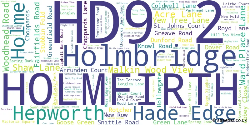
A word cloud for the HD9 2 postcode
A word cloud showing place names for the HD9 2 postcode sector, can you see your street?
Postcode format for the HD9 2 postcode sector
H D 9 - 2 X X
H D 9 Space 2 Letter Letter
Advertisement

Street List for HD9 2

ABBEY CLOSE

HADE EDGE, Holmfirth, West Yorkshire

Local Road USRN: 19401074

ABBEY COURT

HADE EDGE, Holmfirth, West Yorkshire

Local Road USRN: 19418430

ACRE LANE
C-Road

HOLMBRIDGE, Holmfirth, West Yorkshire

Minor Road USRN: 19401075

ACRES LANE
C-Road

Holmfirth, West Yorkshire

Minor Road USRN: 19401076

ADELINE TERRACE

HOLMBRIDGE, Holmfirth, West Yorkshire

Restricted Local Access Road USRN: 19418432

ARRUNDEN COURT

Holmfirth, West Yorkshire

USRN: 19418449

ARRUNDEN LANE

CARTWORTH MOOR, Holmfirth, West Yorkshire

Local Road USRN: 19401080

ASH GROVE ROAD

Holmfirth, West Yorkshire

Local Road USRN: 19401081

ATTORNEY COURT

Holmfirth, West Yorkshire

Restricted Local Access Road USRN: 19421138

BANK LANE
C-Road

Holmfirth, West Yorkshire

Minor Road USRN: 19401084

BANK LANE
C-Road

HOLMBRIDGE, Holmfirth, West Yorkshire

Minor Road USRN: 19401083

BANK TOP LANE
C-Road

HOLMBRIDGE, Holmfirth, West Yorkshire

Minor Road USRN: 19401086

BANKFIELD DRIVE

HOLMBRIDGE, Holmfirth, West Yorkshire

Local Road USRN: 19401087

BARE BONES ROAD
C-Road

HARDEN, Barnsley, South Yorkshire

Minor Road USRN: 1802562

BARE BONES ROAD
C-Road

HARDEN, Barnsley, West Yorkshire

Minor Road USRN: 1802562

BAYFIELD CLOSE

HADE EDGE, Holmfirth, West Yorkshire

Local Road USRN: 19401088

BEDDING EDGE ROAD
C-Road

HEPWORTH, Barnsley, South Yorkshire

Minor Road USRN: 1802563

BEDDING EDGE ROAD
C-Road

HEPWORTH, Barnsley, West Yorkshire

Minor Road USRN: 1802563

BENT LANE

Holmfirth, West Yorkshire

Local Road USRN: 19401090

BENT ROAD
C-Road

HEPWORTH, Holmfirth, West Yorkshire

Minor Road USRN: 19400834

BLACK SIKE LANE
C-Road

Holmfirth, West Yorkshire

Minor Road USRN: 19401093

BOOTH HOUSE LANE
C-Road

Holmfirth, West Yorkshire

Minor Road USRN: 19401094

BOSHAW VIEW

HADE EDGE, Holmfirth, West Yorkshire

Local Road USRN: 19424087

BRIAR COURT

Holmfirth, West Yorkshire

Local Access Road USRN: 19401096

BROADFIELD PARK

HOLMBRIDGE, Holmfirth, West Yorkshire

Local Road USRN: 19418544

BROW LANE
C-Road

Holmfirth, West Yorkshire

Minor Road USRN: 19401100

BROWNHILL LANE

HOLMBRIDGE, Holmfirth, West Yorkshire

Local Road USRN: 19401101

BRYNDLEE COURT

Holmfirth, West Yorkshire

Local Road USRN: 19422685

BURLEY BANK LANE

HOLME, Holmfirth, West Yorkshire

USRN: 19401371

BURNLEE GREEN ROAD
C-Road

Holmfirth, West Yorkshire

Minor Road USRN: 19420138

BURNLEE ROAD
C-Road

Holmfirth, West Yorkshire

Minor Road USRN: 19401104

BURNSIDE DRIVE

Holmfirth, West Yorkshire

Local Road USRN: 19401105

CARR LANE
C-Road

Holmfirth, West Yorkshire

Minor Road USRN: 19401108

CARTWORTH BANK ROAD
C-Road

CARTWORTH MOOR, Holmfirth, West Yorkshire

Minor Road USRN: 19401109

CARTWORTH LANE

Holmfirth, West Yorkshire

Restricted Local Access Road USRN: 19401110

CARTWORTH MOOR ROAD
C-Road

CARTWORTH MOOR, Holmfirth, West Yorkshire

Minor Road USRN: 19401372

CARTWORTH ROAD
C-Road

Holmfirth, West Yorkshire

Minor Road USRN: 19401112

CEMETERY ROAD
C-Road

Holmfirth, West Yorkshire

Minor Road USRN: 19401113

CHOPPARDS BANK ROAD
C-Road

Holmfirth, West Yorkshire

Minor Road USRN: 19401114

CHOPPARDS LANE
C-Road

CARTWORTH MOOR, Holmfirth, West Yorkshire

Minor Road USRN: 19401115

CHURCH VIEW

HOLMBRIDGE, Holmfirth, West Yorkshire

Local Road USRN: 19401117

CLIFF ROAD

HOLME, Holmfirth, West Yorkshire

USRN: 19420155

CLOUGH FOOT LANE

Holmfirth, West Yorkshire

Restricted Local Access Road USRN: 19401124

CO-OP LANE
C-Road

HOLMBRIDGE, Holmfirth, West Yorkshire

Minor Road USRN: 19401126

COLD WELL LANE
C-Road

HOLMBRIDGE, Holmfirth, West Yorkshire

Minor Road USRN: 19401125

COPTHURST ROAD

CARTWORTH MOOR, Holmfirth, West Yorkshire

Local Access Road USRN: 19401128

COTE LANE
C-Road

Holmfirth, West Yorkshire

Minor Road USRN: 19401129

CROSS GATE ROAD
C-Road

Holmfirth, West Yorkshire

Minor Road USRN: 19401132

CROW HILL ROAD

HOLMBRIDGE, Holmfirth, West Yorkshire

USRN: 19420171

DAISY LEE LANE

HADE EDGE, Holmfirth, West Yorkshire

Restricted Local Access Road USRN: 19400871

DAM HEAD

HOLMBRIDGE, Holmfirth, West Yorkshire

Restricted Local Access Road USRN: 19418666

DEAN ROAD
C-Road

UPPERTHONG, Holmfirth, West Yorkshire

Minor Road USRN: 19423149

DIGLEY ROAD

HOLMBRIDGE, Holmfirth, West Yorkshire

Local Road USRN: 19401140

DIGLEY ROYD LANE
C-Road

Holmfirth, West Yorkshire

Minor Road USRN: 19401141

DOBB LANE
C-Road

HOLMBRIDGE, Holmfirth, West Yorkshire

Minor Road USRN: 19401142

DOBB TOP ROAD
C-Road

HOLMBRIDGE, Holmfirth, West Yorkshire

Minor Road USRN: 19401143

DOVER LANE

Holmfirth, West Yorkshire

Local Road USRN: 19401144

DOVER ROAD

Holmfirth, West Yorkshire

Local Road USRN: 19401145

DUNFORD ROAD
C-Road

HARDEN, Barnsley, South Yorkshire

Minor Road USRN: 1802568

DUNFORD ROAD
C-Road

HADE EDGE, Holmfirth, South Yorkshire

Minor Road USRN: 19422908

DUNFORD ROAD
C-Road

HADE EDGE, Holmfirth, West Yorkshire

Minor Road USRN: 19422908

DUNFORD ROAD B6106
B-Road

Holmfirth, West Yorkshire

B Road USRN: 19422907

DUNSLEY BANK ROAD

Holmfirth, West Yorkshire

Restricted Local Access Road USRN: 19401147

DUNSLEY ROAD

Holmfirth, West Yorkshire

USRN: 19420181

EDGE END LANE
C-Road

Holmfirth, West Yorkshire

Minor Road USRN: 19401149

FAIRFIELDS ROAD
C-Road

HOLMBRIDGE, Holmfirth, West Yorkshire

Minor Road USRN: 19401150

FIELD END LANE
C-Road

HOLMBRIDGE, Holmfirth, West Yorkshire

Minor Road USRN: 19401151

FIELDHEAD LANE
C-Road

HOLME, Holmfirth, West Yorkshire

Minor Road USRN: 19401153

FLIGHT HILL
C-Road

DUNFORD BRIDGE, Barnsley, South Yorkshire

Minor Road USRN: 1802547

FLIGHT HILL
C-Road

DUNFORD BRIDGE, Barnsley, West Yorkshire

Minor Road USRN: 1802547

FLINT LANE B6106
B-Road

HEPWORTH, Barnsley, South Yorkshire

B Road USRN: 1802557

FLUSH HOUSE LANE
C-Road

HOLMBRIDGE, Holmfirth, West Yorkshire

Minor Road USRN: 19401155

FOLLY LANE

HADE EDGE, Holmfirth, West Yorkshire

USRN: 19420009

FORD GATE
C-Road

HOLMBRIDGE, Holmfirth, West Yorkshire

Minor Road USRN: 19401156

FURTHER END LANE

HOLME, Holmfirth, West Yorkshire

USRN: 19420192

GIBRIDING LANE

Holmfirth, West Yorkshire

USRN: 19401157

GILL LANE
C-Road

CARTWORTH MOOR, Holmfirth, West Yorkshire

Minor Road USRN: 19401159

GOOSE GREEN

Holmfirth, West Yorkshire

Local Road USRN: 19401160

GREAVE ROAD
C-Road

HADE EDGE, Holmfirth, West Yorkshire

Minor Road USRN: 19401161

GREEN ABBEY

HADE EDGE, Holmfirth, West Yorkshire

Local Road USRN: 19401162

GREEN GATE ROAD
C-Road

Holmfirth, West Yorkshire

Minor Road USRN: 19401163

GREEN LANE
C-Road

Holmfirth, West Yorkshire

Minor Road USRN: 19401164

GREENFIELD ROAD A635
A-Road

Holmfirth, Greater Manchester

A Road USRN: 19401165

GREENFIELD ROAD A635
A-Road

Holmfirth, West Yorkshire

A Road USRN: 19401165

GUINEA GATE

HADE EDGE, Holmfirth, West Yorkshire

Restricted Local Access Road USRN: 19420016

HARDEN MOSS ROAD

Holmfirth, West Yorkshire

Restricted Local Access Road USRN: 19401170

HEALD COURT

HOLMBRIDGE, Holmfirth, West Yorkshire

USRN: 19421764

HILL HOUSE LANE

Holmfirth, West Yorkshire

Restricted Local Access Road USRN: 19401180

HILL HOUSE ROAD
C-Road

Holmfirth, West Yorkshire

Minor Road USRN: 19401181

HILL TOP ROAD

CARTWORTH MOOR, Holmfirth, West Yorkshire

Local Road USRN: 19401183

HILL TOP VIEW

HADE EDGE, Holmfirth, West Yorkshire

Local Road USRN: 19420269

HOGLEY LANE

Holmfirth, West Yorkshire

Local Road USRN: 19401184

HOLLIN BRIGG LANE
C-Road

HOLMBRIDGE, Holmfirth, West Yorkshire

Minor Road USRN: 19401185

HOLLOWGATE

Holmfirth, West Yorkshire

Local Road USRN: 19401186

HOLMCLOSE

HOLMBRIDGE, Holmfirth, West Yorkshire

Local Road USRN: 19401187

HOLME STYES LANE

Holmfirth, West Yorkshire

USRN: 19401189

HOLME WOODS LANE

HOLME, Holmfirth, West Yorkshire

Restricted Local Access Road USRN: 19401375

HOLMFIRTH ROAD
C-Road

HARDEN, Barnsley, South Yorkshire

Minor Road USRN: 1802569

HOOWOOD LANE

Holmfirth, West Yorkshire

Restricted Local Access Road USRN: 19401195

HOPEFIELD COURT

HADE EDGE, Holmfirth, West Yorkshire

Restricted Local Access Road USRN: 19420243

HUDDERSFIELD ROAD A6024
A-Road

Holmfirth, West Yorkshire

A Road USRN: 19422854

KILN BENT ROAD

HOLME, Holmfirth, West Yorkshire

Restricted Local Access Road USRN: 19401376

KILNHOUSE BANK LANE

HOLMBRIDGE, Holmfirth, West Yorkshire

Restricted Local Access Road USRN: 19401199

KNOWL ROAD

Holmfirth, West Yorkshire

USRN: 19401201

LAITHE AVENUE

HOLMBRIDGE, Holmfirth, West Yorkshire

Local Road USRN: 19401202

LAITHE BANK DRIVE

HOLMBRIDGE, Holmfirth, West Yorkshire

Local Road USRN: 19401203

LAITHE COURT

HOLMBRIDGE, Huddersfield, West Yorkshire

Restricted Local Access Road USRN: 19423331

LAMMA WELL ROAD
C-Road

CARTWORTH MOOR, Holmfirth, West Yorkshire

Minor Road USRN: 19401205

LAW COMMON ROAD
C-Road

DUNFORD BRIDGE, Barnsley, South Yorkshire

Minor Road USRN: 1802564

LAW COMMON ROAD
C-Road

DUNFORD BRIDGE, Barnsley, West Yorkshire

Minor Road USRN: 1802564

LAW SLACK ROAD
C-Road

HADE EDGE, Holmfirth, West Yorkshire

Minor Road USRN: 19401355

LINSHAWS ROAD
C-Road

Holmfirth, South Yorkshire

Minor Road USRN: 19401377

LINSHAWS ROAD
C-Road

HARDEN, Barnsley, South Yorkshire

Minor Road USRN: 1802580

LINSHAWS ROAD
C-Road

HARDEN, Barnsley, West Yorkshire

Minor Road USRN: 1802580

LIPHILL BANK ROAD

Holmfirth, West Yorkshire

Local Road USRN: 19401206

LITTLE CROFT CLOSE

Holmfirth, West Yorkshire

USRN: 19424301

LITTLE LANE

Holmfirth, West Yorkshire

Restricted Local Access Road USRN: 19401207

LONG ING

Holmfirth, West Yorkshire

USRN: 19424209

LONG ING ROAD

HADE EDGE, Holmfirth, West Yorkshire

Restricted Local Access Road USRN: 19401208

LONGLEY EDGE LANE

Holmfirth, West Yorkshire

Restricted Local Access Road USRN: 19401210

LONGLEY EDGE ROAD

HADE EDGE, Holmfirth, West Yorkshire

Restricted Local Access Road USRN: 19401211

LONGLEY LANE

Holmfirth, West Yorkshire

Local Road USRN: 19401212

LOW GATE

Holmfirth, West Yorkshire

Local Access Road USRN: 19401213

LOWER MILL LANE

Holmfirth, West Yorkshire

Local Road USRN: 19421139

LUMBANK LANE

HOLME, Holmfirth, West Yorkshire

USRN: 19421861

MAGDALEN ROAD

MELTHAM, Holmfirth, West Yorkshire

Restricted Local Access Road USRN: 19401217

MALKIN WOOD VIEW

Holmfirth, West Yorkshire

USRN: 19423672

MEAL HILL ROAD

HOLME, Holmfirth, West Yorkshire

Restricted Local Access Road USRN: 19401221

MELLOR LANE
C-Road

Holmfirth, West Yorkshire

Minor Road USRN: 19401222

MILLFOLD

HOLMBRIDGE, Holmfirth, West Yorkshire

USRN: 19422678

MISSION VIEW

CARTWORTH MOOR, Holmfirth, West Yorkshire

Local Road USRN: 19421999

MODD LANE

Holmfirth, West Yorkshire

Local Road USRN: 19401225

MOSS EDGE ROAD

HOLMBRIDGE, Holmfirth, West Yorkshire

Restricted Local Access Road USRN: 19401227

MOSS EDGE VIEW

HOLMBRIDGE, Holmfirth, West Yorkshire

Local Road USRN: 19422706

NETHER LANE

Holmfirth, West Yorkshire

Restricted Local Access Road USRN: 19400029

NEW FOLD

Holmfirth, West Yorkshire

Local Access Road USRN: 19401233

NEW ROW

Holmfirth, West Yorkshire

USRN: 19401237

OLD GATE

HOLME, Holmfirth, West Yorkshire

USRN: 19401240

OLD LANE

Holmfirth, West Yorkshire

USRN: 19400030

OLD ROAD

HOLMBRIDGE, Holmfirth, West Yorkshire

Local Road USRN: 19401241

OLD YEW LANE

Holmfirth, West Yorkshire

Restricted Local Access Road USRN: 19401242

PARK HEAD LANE
C-Road

Holmfirth, West Yorkshire

Minor Road USRN: 19401244

PENISTONE ROAD B6106
B-Road

HADE EDGE, Holmfirth, West Yorkshire

B Road USRN: 19423102

PENISTONE ROAD B6106
B-Road

HEPWORTH, Holmfirth, West Yorkshire

B Road USRN: 19423103

PERSEVERANCE PLACE

Holmfirth, West Yorkshire

Local Road USRN: 19423259

RAKE HEAD ROAD

HOLME, Holmfirth, West Yorkshire

Restricted Local Access Road USRN: 19401248

RAMSDEN LANE

HOLMBRIDGE, Holmfirth, West Yorkshire

Restricted Local Access Road USRN: 19401249

RAMSDEN ROAD

HOLMBRIDGE, Holmfirth, West Yorkshire

Restricted Local Access Road USRN: 19401378

RICH GATE
C-Road

Holmfirth, West Yorkshire

Minor Road USRN: 19401251

ROODS LANE
C-Road

HOLMBRIDGE, Holmfirth, West Yorkshire

Minor Road USRN: 19401253

ROTCHER ROAD
C-Road

Holmfirth, West Yorkshire

Minor Road USRN: 19401254

ROUND CLOSE ROAD

HADE EDGE, Holmfirth, West Yorkshire

Restricted Local Access Road USRN: 19401379

ROYD LANE
C-Road

Holmfirth, West Yorkshire

Minor Road USRN: 19401255

ROYD MOUNT

Holmfirth, West Yorkshire

Local Road USRN: 19401256

RYE CLOSE LANE

Holmfirth, West Yorkshire

USRN: 19401259

SCAR FOLD

Holmfirth, West Yorkshire

Local Road USRN: 19401261

SCHOLES MOOR ROAD
C-Road

HADE EDGE, Holmfirth, West Yorkshire

Minor Road USRN: 19423151

SHAW LANE
C-Road

Holmfirth, West Yorkshire

Minor Road USRN: 19401265

SHAWFIELD AVENUE

Holmfirth, West Yorkshire

Local Road USRN: 19401266

SHAY LANE

Holmfirth, West Yorkshire

Restricted Local Access Road USRN: 19401267

SMITHY LANE
C-Road

HOLMBRIDGE, Holmfirth, West Yorkshire

Minor Road USRN: 19401269

SNITTLE ROAD

HADE EDGE, Holmfirth, South Yorkshire

Restricted Local Access Road USRN: 19401380

SNITTLE ROAD

HADE EDGE, Holmfirth, West Yorkshire

Restricted Local Access Road USRN: 19401380

SOUTH LANE

Holmfirth, West Yorkshire

Local Road USRN: 19401271

SPARTH LANE

Holmfirth, West Yorkshire

USRN: 19401272

SPRING BANK

Holmfirth, West Yorkshire

Restricted Local Access Road USRN: 19419302

SPRING BANK CROFT

Holmfirth, West Yorkshire

Local Road USRN: 19401273

SPRING LANE

HOLMBRIDGE, Holmfirth, West Yorkshire

Restricted Local Access Road USRN: 19401275

SPRING LANE
C-Road

Holmfirth, West Yorkshire

Minor Road USRN: 19401276

SPRINGS ROAD

Holmfirth, West Yorkshire

USRN: 19400035

ST JOHNS COURT

Holmfirth, West Yorkshire

USRN: 19419332

STANLEY STREET

HOLMBRIDGE, Holmfirth, West Yorkshire

USRN: 19410458

STONY GATE
C-Road

CARTWORTH MOOR, Holmfirth, West Yorkshire

Minor Road USRN: 19401285

STRINES MOOR ROAD
C-Road

HADE EDGE, Holmfirth, West Yorkshire

Minor Road USRN: 19401030

STUBBIN FOLD

HOLMBRIDGE, Holmfirth, West Yorkshire

Local Road USRN: 19420222

STUBBIN LANE

HOLMBRIDGE, Holmfirth, West Yorkshire

Restricted Local Access Road USRN: 19401286

SWAN BANK LANE

Holmfirth, West Yorkshire

Restricted Local Access Road USRN: 19401288

THE ROYDS

Holmfirth, West Yorkshire

Restricted Local Access Road USRN: 19401291

THICK HOLLINS ROAD
C-Road

MELTHAM, Holmfirth, West Yorkshire

Minor Road USRN: 19403676

TINKERS LANE

HOLME, Holmfirth, West Yorkshire

USRN: 19421860

TURF GATE

HOLME, Holmfirth, West Yorkshire

USRN: 19420080

UNDER BANK END ROAD
C-Road

Holmfirth, West Yorkshire

Minor Road USRN: 19419503

UNDERBANK OLD ROAD

Holmfirth, West Yorkshire

Local Road USRN: 19401300

UPPER ROW

HOLMBRIDGE, Holmfirth, West Yorkshire

USRN: 19419525

UPPERTHONG LANE

Holmfirth, West Yorkshire

Local Road USRN: 19423044

VICTORIA MILLS

Holmfirth, West Yorkshire

Local Road USRN: 19422676

VICTORIA SPRINGS

Holmfirth, West Yorkshire

Local Road USRN: 19401305

VICTORIA SQUARE A635
A-Road

Holmfirth, West Yorkshire

A Road USRN: 19401306

VICTORIA STREET A635
A-Road

Holmfirth, West Yorkshire

A Road USRN: 19401307

WALTIN ROAD

CARTWORTH MOOR, Holmfirth, West Yorkshire

USRN: 19401308

WARD BANK ROAD

Holmfirth, West Yorkshire

USRN: 19401309

WARD PLACE LANE

Holmfirth, West Yorkshire

Restricted Local Access Road USRN: 19401310

WASHPIT NEW ROAD
C-Road

Holmfirth, West Yorkshire

Minor Road USRN: 19401311

WATER SIDE LANE

HOLMBRIDGE, Holmfirth, West Yorkshire

Restricted Local Access Road USRN: 19401312

WATER STREET

HOLMBRIDGE, Holmfirth, West Yorkshire

Local Road USRN: 19401313

WATERY LANE

HOLME, Holmfirth, West Yorkshire

Restricted Local Access Road USRN: 19401314

WEATHER HILL LANE

CARTWORTH MOOR, Holmfirth, West Yorkshire

Restricted Local Access Road USRN: 19401315

WELL HILL ROAD

Holmfirth, West Yorkshire

Local Road USRN: 19401317

WELLHOUSES

CARTWORTH MOOR, Holmfirth, West Yorkshire

Restricted Local Access Road USRN: 19410470

WESSENDEN HEAD ROAD
C-Road

MELTHAM, Holmfirth, West Yorkshire

Minor Road USRN: 19400755

WEST GATE

CARTWORTH MOOR, Holmfirth, West Yorkshire

Restricted Local Access Road USRN: 19401320

WHEAT CLOSE

HOLMBRIDGE, Holmfirth, West Yorkshire

Local Access Road USRN: 19401322

WHITE GATE ROAD
C-Road

CARTWORTH MOOR, Holmfirth, West Yorkshire

Minor Road USRN: 19401381

WHITE WALLS LANE

Holmfirth, West Yorkshire

Restricted Local Access Road USRN: 19401324

WILD BOAR CLOUGH

HADE EDGE, Holmfirth, West Yorkshire

Restricted Local Access Road USRN: 19422088

WOODHEAD ROAD A6024
A-Road

HOLMBRIDGE, Holmfirth, West Yorkshire

A Road USRN: 19422817

WOODHEAD ROAD A6024
A-Road

HOLME, Holmfirth, West Yorkshire

A Road USRN: 19422818

WOODHEAD ROAD A6024
A-Road

Holmfirth, West Yorkshire

A Road USRN: 19422816

WOODHOUSE LANE
C-Road

HOLMBRIDGE, Holmfirth, West Yorkshire

Minor Road USRN: 19401334

WOODHOUSE ROAD

CARTWORTH MOOR, Holmfirth, West Yorkshire

Restricted Local Access Road USRN: 19422108

WOODSIDE VIEW

Holmfirth, West Yorkshire

Local Road USRN: 19401335

YEW TREE LANE
C-Road

HOLMBRIDGE, Holmfirth, West Yorkshire

Minor Road USRN: 19401337

Weather Forecast for HD9 2

Weather Forecast for Black Hill

Schools and Places of Education Within the HD9 2 Postcode Sector

Hade Edge Junior, Infant and Nursery School
Community school

Greave Road, Holmfirth, West Yorkshire, HD9 2DF
Head: Mrs Gemma Koltuk
Ofsted Rating: Requires improvement
Inspection: 2023-11-15 (609 days ago)
Website: Visit Hade Edge Junior, Infant and Nursery School Website
Phone: 01484682782
Number of Pupils: 91

Hinchliffe Mill Junior and Infant School
Community school

Waterside Lane, Holmfirth, West Yorkshire, HD9 2PF
Head: Mr Damien Bond (Acting)
Ofsted Rating: Good
Inspection: 2019-01-17 (2372 days ago)
Website: Visit Hinchliffe Mill Junior and Infant School Website
Phone: 01484689692
Number of Pupils: 75

Holme Junior and Infant School
Community school

Meal Hill Road, Holmfirth, West Yorkshire, HD9 2QQ
Head: Mr Damien Bond
Ofsted Rating: Good
Inspection: 2019-01-17 (2372 days ago)
Website: Visit Holme Junior and Infant School Website
Phone: 01484687362
Number of Pupils: 33

Holmfirth Junior Infant and Nursery School
Community school

Cartworth Road, Holmfirth, West Yorkshire, HD9 2RG
Head: Mr Julian Rose
Ofsted Rating: Good
Inspection: 2022-06-15 (1127 days ago)
Website: Visit Holmfirth Junior Infant and Nursery School Website
Phone: 01484687565
Number of Pupils: 196

Upperthong Junior and Infant School
Community school

Burnlee Road, Holmfirth, West Yorkshire, HD9 2LE
Head: Mrs Carolyn Littlewood
Ofsted Rating: Good
Inspection: 2023-02-23 (874 days ago)
Website: Visit Upperthong Junior and Infant School Website
Phone: 01484683176
Number of Pupils: 207
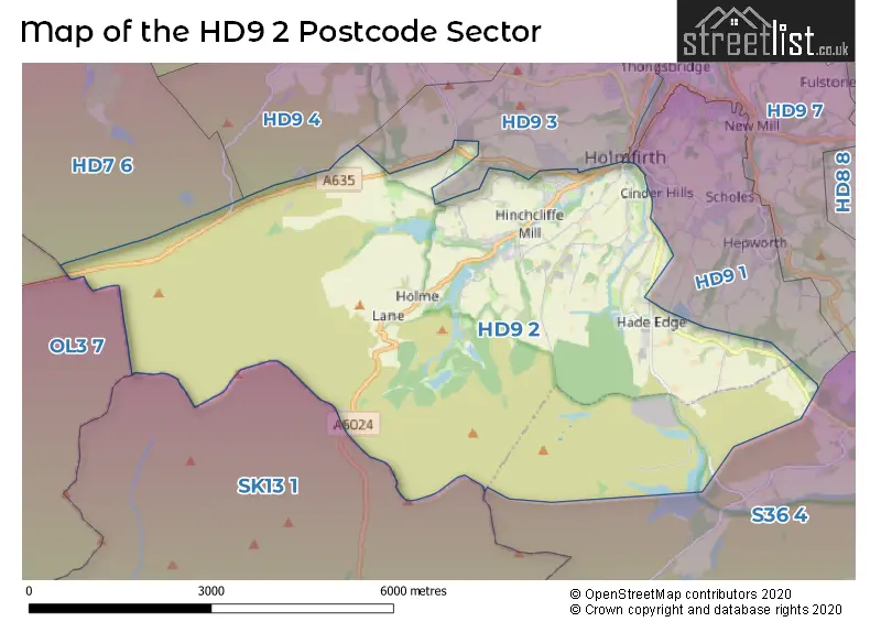
Map of the HD9 2 and surrounding postcode sector

House Prices in the HD9 2 Postcode Sector

Yearly House Price Averages for the HD9 2 Postcode Sector
Type of Property 2018 Average 2018 Sales 2017 Average 2017 Sales 2016 Average 2016 Sales 2015 Average 2015 Sales
Detached £370,810 29 £377,614 22 £359,262 21 £340,900 33
Semi-Detached £249,960 20 £335,697 19 £209,499 21 £190,107 21
Terraced £177,113 30 £171,525 32 £158,697 35 £158,759 44
Flats £111,900 8 £98,722 9 £122,845 10 £105,958 12

Important Postcodes HD9 2 in the Postcode Sector

HD9 2DF

HD9 2DF is the postcode for Hade Edge Primary School, Greave Road

HD9 2DR

HD9 2DR is the postcode for Phoenix Youth Club, Dunford Road

HD9 2LE

HD9 2LE is the postcode for Upperthong Junior & Infant School, Burnlee Road

HD9 2PF

HD9 2PF is the postcode for Hinchliffe Mill County School, Waterside Lane

HD9 2QQ

HD9 2QQ is the postcode for Holme School, Meal Hill Road

HD9 2RG

HD9 2RG is the postcode for Holmfirth Junior Infant & Nursery School, Cartworth Road

The HD9 2 Sector is within these Local Authorities
  • High Peak District (B)
  • Kirklees District (B)
  • Oldham District (B)
  • Barnsley District (B)
The HD9 2 Sector is within these Counties
  • Derbyshire
  • West Yorkshire
  • Greater Manchester
  • South Yorkshire
The HD9 2 Sector is within these Water Company Areas
  • United Utilities
  • Yorkshire

Tourist Attractions within the HD9 2 Postcode Area

We found 1 visitor attractions within the HD9 postcode area

Last of the Summer Wine Exhibition
Museums & Art Galleries
Museum and / or Art Gallery
View Last of the Summer Wine Exhibition on Google Maps