The HP10 postcode district is a postal district located in the HP Hemel Hempstead postcode area with a population of 19,366 residents according to the 2021 England and Wales Census.
The area of the HP10 postcode district is 11.72 square miles which is 30.36 square kilometres or 7,501.79 acres.
Currently, the HP10 district has about 553 postcode units spread across 3 geographic postcode sectors.
Given that each sector allows for 400 unique postcode combinations, the district has a capacity of 1,200 postcodes. With 553 postcodes already in use, this leaves 647 units available.
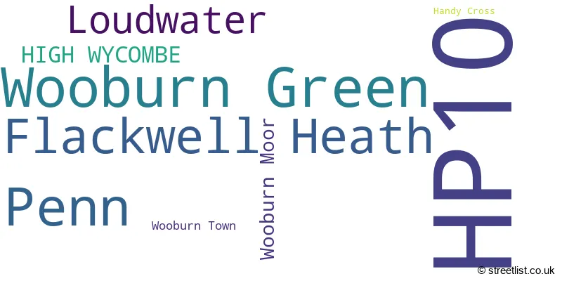
The largest settlement in the HP10 postal code is Wooburn Green followed by Flackwell Heath, and Penn.
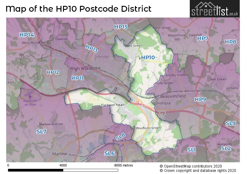
The HP10 Postcode shares a border with HP11 (HIGH WYCOMBE), HP13 (HIGH WYCOMBE, Downley), HP15 (Hazlemere, Holmer Green, Great Kingshill), HP9 (BEACONSFIELD, Seer Green, Knotty Green), SL7 (MARLOW, Medmenham, Booker), SL8 (BOURNE END) and SL1 (SLOUGH, Burnham).
The primary settlement in the HP10 postcode district is Wooburn Green, located in the county of Buckinghamshire, England. Other significant settlements in this district include Wooburn Moor, Wooburn Town, Penn, Flackwell Heath, Handy Cross, and Loudwater. The post town associated with the highest number of postcodes in the district is High Wycombe.
For the district HP10, we have data on 3 postcode sectors. Here's a breakdown: The sector HP10 0, covers Wooburn Green in Buckinghamshire. The sector HP10 8, covers Penn in Buckinghamshire. The sector HP10 9, covers Flackwell Heath and Loudwater in Buckinghamshire.

Map of the HP10 Postcode District
Explore the HP10 postcode district by using our free interactive map.
When it comes to local government, postal geography often disregards political borders. However, for a breakdown in the HP10 District: the district mostly encompasses the Buckinghamshire area with a total of 562 postcodes.
Recent House Sales in HP10
| Date | Price | Address |
|---|---|---|
| 19/10/2023 | £340,000 | Heath End Road, Flackwell Heath, High Wycombe, HP10 9DU |
| 06/10/2023 | £475,000 | Chiltern Green, Flackwell Heath, High Wycombe, HP10 9AJ |
| 11/09/2023 | £243,000 | Northcroft, Wooburn Green, High Wycombe, HP10 0BZ |
| 08/09/2023 | £535,000 | Sedgmoor Gardens, Flackwell Heath, High Wycombe, HP10 9AR |
| 04/09/2023 | £650,000 | London Road, Wooburn Green, High Wycombe, HP10 0NJ |
| 01/09/2023 | £191,000 | Knaves Hollow, Wooburn Moor, High Wycombe, HP10 0PB |
| 31/08/2023 | £430,000 | Orchard Drive, Wooburn Green, High Wycombe, HP10 0QN |
| 25/08/2023 | £550,000 | The Green, Wooburn Green, High Wycombe, HP10 0EE |
| 25/08/2023 | £185,000 | Hedge Lea, Wooburn Green, High Wycombe, HP10 0DA |
| 24/08/2023 | £835,000 | Whitepit Lane, Flackwell Heath, High Wycombe, HP10 9HT |
Weather Forecast for HP10
Press Button to Show Forecast for Wycombe Summit Ski & Snowboarding Centre
| Time Period | Icon | Description | Temperature | Rain Probability | Wind |
|---|---|---|---|---|---|
| 21:00 to 00:00 | Partly cloudy (night) | 5.0°C (feels like 2.0°C) | 14.00% | NNW 9 mph |
Press Button to Show Forecast for Wycombe Summit Ski & Snowboarding Centre
| Time Period | Icon | Description | Temperature | Rain Probability | Wind |
|---|---|---|---|---|---|
| 00:00 to 03:00 | Cloudy | 4.0°C (feels like 1.0°C) | 8.00% | NNW 11 mph | |
| 03:00 to 06:00 | Cloudy | 4.0°C (feels like 1.0°C) | 7.00% | N 9 mph | |
| 06:00 to 09:00 | Sunny day | 4.0°C (feels like 1.0°C) | 0.00% | N 9 mph | |
| 09:00 to 12:00 | Sunny day | 8.0°C (feels like 6.0°C) | 0.00% | N 7 mph | |
| 12:00 to 15:00 | Partly cloudy (day) | 11.0°C (feels like 10.0°C) | 1.00% | WNW 4 mph | |
| 15:00 to 18:00 | Cloudy | 12.0°C (feels like 10.0°C) | 5.00% | W 9 mph | |
| 18:00 to 21:00 | Cloudy | 10.0°C (feels like 8.0°C) | 7.00% | W 9 mph | |
| 21:00 to 00:00 | Overcast | 8.0°C (feels like 6.0°C) | 20.00% | WSW 11 mph |
Press Button to Show Forecast for Wycombe Summit Ski & Snowboarding Centre
| Time Period | Icon | Description | Temperature | Rain Probability | Wind |
|---|---|---|---|---|---|
| 00:00 to 03:00 | Overcast | 8.0°C (feels like 5.0°C) | 49.00% | W 11 mph | |
| 03:00 to 06:00 | Overcast | 8.0°C (feels like 5.0°C) | 16.00% | W 11 mph | |
| 06:00 to 09:00 | Overcast | 9.0°C (feels like 6.0°C) | 10.00% | WNW 11 mph | |
| 09:00 to 12:00 | Partly cloudy (day) | 10.0°C (feels like 7.0°C) | 2.00% | NW 16 mph | |
| 12:00 to 15:00 | Overcast | 11.0°C (feels like 8.0°C) | 17.00% | NW 18 mph | |
| 15:00 to 18:00 | Cloudy | 12.0°C (feels like 9.0°C) | 6.00% | NNW 16 mph | |
| 18:00 to 21:00 | Cloudy | 10.0°C (feels like 8.0°C) | 4.00% | NNW 11 mph | |
| 21:00 to 00:00 | Cloudy | 8.0°C (feels like 6.0°C) | 7.00% | N 7 mph |
Press Button to Show Forecast for Wycombe Summit Ski & Snowboarding Centre
| Time Period | Icon | Description | Temperature | Rain Probability | Wind |
|---|---|---|---|---|---|
| 00:00 to 03:00 | Partly cloudy (night) | 6.0°C (feels like 4.0°C) | 4.00% | N 7 mph | |
| 03:00 to 06:00 | Partly cloudy (night) | 5.0°C (feels like 2.0°C) | 1.00% | N 7 mph | |
| 06:00 to 09:00 | Partly cloudy (day) | 4.0°C (feels like 1.0°C) | 1.00% | N 9 mph | |
| 09:00 to 12:00 | Partly cloudy (day) | 7.0°C (feels like 4.0°C) | 1.00% | N 11 mph | |
| 12:00 to 15:00 | Overcast | 9.0°C (feels like 7.0°C) | 7.00% | N 9 mph | |
| 15:00 to 18:00 | Cloudy | 10.0°C (feels like 8.0°C) | 4.00% | N 9 mph | |
| 18:00 to 21:00 | Cloudy | 9.0°C (feels like 8.0°C) | 5.00% | NNE 7 mph | |
| 21:00 to 00:00 | Partly cloudy (night) | 7.0°C (feels like 5.0°C) | 1.00% | NNE 4 mph |
Press Button to Show Forecast for Wycombe Summit Ski & Snowboarding Centre
| Time Period | Icon | Description | Temperature | Rain Probability | Wind |
|---|---|---|---|---|---|
| 00:00 to 03:00 | Partly cloudy (night) | 5.0°C (feels like 3.0°C) | 1.00% | NE 4 mph | |
| 03:00 to 06:00 | Partly cloudy (night) | 4.0°C (feels like 2.0°C) | 1.00% | N 4 mph | |
| 06:00 to 09:00 | Partly cloudy (day) | 5.0°C (feels like 3.0°C) | 2.00% | N 4 mph | |
| 09:00 to 12:00 | Cloudy | 8.0°C (feels like 6.0°C) | 6.00% | N 7 mph | |
| 12:00 to 15:00 | Overcast | 11.0°C (feels like 9.0°C) | 9.00% | NNE 9 mph | |
| 15:00 to 18:00 | Overcast | 11.0°C (feels like 9.0°C) | 9.00% | NNE 9 mph | |
| 18:00 to 21:00 | Overcast | 11.0°C (feels like 9.0°C) | 12.00% | NNE 7 mph | |
| 21:00 to 00:00 | Partly cloudy (night) | 8.0°C (feels like 6.0°C) | 8.00% | NE 7 mph |
Where is the HP10 Postcode District?
The postcode district HP10 corresponds to the town of High Wycombe. It is located near several nearby towns, including Bourne End to the south (2.45 miles away), Beaconsfield to the east (3.72 miles away), Marlow to the southwest (4.56 miles away), and Great Missenden to the north (6.50 miles away). High Wycombe is approximately 25.44 miles away from the center of London.
The district is within the post town of HIGH WYCOMBE.
The sector has postcodes within the nation of England.
The HP10 Postcode District is in the region of within the .
| Postcode Sector | Delivery Office |
|---|---|
| HP10 0 | High Wycombe South Postal Delivery Office |
| HP10 8 | High Wycombe South Postal Delivery Office |
| HP10 9 | High Wycombe South Postal Delivery Office |
| H | P | 1 | 0 | - | X | X | X |
| H | P | 1 | 0 | Space | Numeric | Letter | Letter |
Tourist Attractions within the Postcode Area
We found 1 visitor attractions within the HP10 postcode area
| Odds Farm Park |
|---|
| Farms |
| Farm / Rare Breeds / Farm Animals |
| View Odds Farm Park on Google Maps |
Current Monthly Rental Prices
| # Bedrooms | Min Price | Max Price | Avg Price |
|---|---|---|---|
| 1 | £700 | £2,000 | £1,217 |
| 2 | £1,335 | £1,650 | £1,521 |
| 3 | £2,250 | £3,000 | £2,667 |
| 4 | £2,300 | £2,300 | £2,300 |
| 5 | £25,000 | £25,000 | £25,000 |
| 6 | £25,000 | £25,000 | £25,000 |
Current House Prices
| # Bedrooms | Min Price | Max Price | Avg Price |
|---|---|---|---|
| £200,000 | £1,285,000 | £742,500 | |
| 1 | £190,000 | £390,000 | £268,750 |
| 2 | £150,750 | £680,000 | £419,366 |
| 3 | £225,000 | £1,045,000 | £562,823 |
| 4 | £450,000 | £2,250,000 | £967,374 |
| 5 | £649,995 | £2,495,000 | £1,294,524 |
| 6 | £1,300,000 | £8,000,000 | £3,393,125 |
| 7 | £2,950,000 | £3,595,000 | £3,272,500 |
| 9 | £3,750,000 | £3,750,000 | £3,750,000 |
Estate Agents who Operate in the HP10 District
| Logo | Name | Brand Name | Address | Contact Number | Total Properties |
|---|---|---|---|---|---|
 | Wooburn Green | Crendon House Estate Agents | Suffolk House The Green, Wooburn Green, HP10 0EU | 01628 882570 | 32 |
 | Flackwell Heath | The Frost Partnership | Acorn House, Straight Bit, Flackwell Heath, HP10 9LS | 01628 334878 | 26 |
 | Flackwell Heath | Robertsons Estate Agents | Swains House, Swains Lane, Flackwell Heath, Buckinghamshire, HP10 9BN | 01628 566022 | 16 |
 | Beaconsfield | Bovingdons | 7/8 The Arcade, Maxwell Road, Beaconsfield, HP9 1QT | 01494 341012 | 10 |
 | Bourne End | Andrew Milsom | 5 - 9 The Parade, Bourne End, Buckinghamshire, SL8 5SA | 01628 563701 | 10 |
| Type of Property | 2018 Average | 2018 Sales | 2017 Average | 2017 Sales | 2016 Average | 2016 Sales | 2015 Average | 2015 Sales |
|---|---|---|---|---|---|---|---|---|
| Detached | £722,285 | 95 | £842,346 | 118 | £733,207 | 104 | £669,855 | 130 |
| Semi-Detached | £452,582 | 82 | £471,913 | 90 | £435,751 | 113 | £397,953 | 88 |
| Terraced | £400,141 | 44 | £386,025 | 47 | £348,091 | 53 | £350,105 | 58 |
| Flats | £239,467 | 36 | £261,774 | 75 | £240,538 | 64 | £204,682 | 75 |
Hotels within the Postcode Area
We found 1 hotels and guest houses within the HP10 postcode area
The Chequers Inn
Kiln Lane, Wooburn Common, Nr. Beaconsfield, beaconsfield-buckinghamsh, HP10 0JQ.
View details