The HP13 7 postcode sector is within the county of Buckinghamshire.
Did you know? According to the 2021 Census, the HP13 7 postcode sector is home to a bustling 16,929 residents!
Given that each sector allows for 400 unique postcode combinations. Letters C, I, K, M, O and V are not allowed in the last two letters of a postcode. With 292 postcodes already in use, this leaves 108 units available.
The HP13 7 postal code covers the settlement of HIGH WYCOMBE.
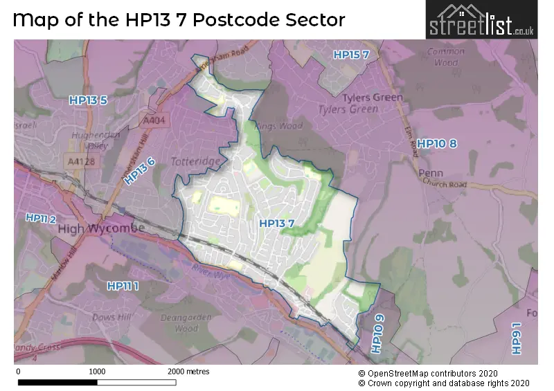
The HP13 7 Postcode shares a border with HP13 5 (HIGH WYCOMBE, Downley), HP13 6 (HIGH WYCOMBE), HP15 7 (Hazlemere), HP10 8 (Penn), HP10 9 (Flackwell Heath, Loudwater, HIGH WYCOMBE) and HP11 1 (HIGH WYCOMBE).
The sector is within the post town of HIGH WYCOMBE.
HP13 7 is a postcode sector within the HP13 postcode district which is within the HP Hemel Hempstead postcode area.
The Royal Mail delivery office for the HP13 7 postal sector is the High Wycombe North Delivery Office.
The area of the HP13 7 postcode sector is 1.58 square miles which is 4.09 square kilometres or 1,010.15 square acres.

Map of the HP13 7 Postcode Sector
Explore the HP13 7 postcode sector by using our free interactive map.
| H | P | 1 | 3 | - | 7 | X | X |
| H | P | 1 | 3 | Space | 7 | Letter | Letter |
Official List of Streets
HIGH WYCOMBE (135 Streets)
Unofficial Streets or Alternative Spellings
HIGH WYCOMBE
BOWERDEAN ROAD BRAMBLESIDE KINGSWOOD PARK NICHOLAS GARDENS OLD HARDENWAYE ROWAN AVENUE THE CRESCENT TOTTERIDGE COMMON TOTTERIDGE DRIVE CLARKE DRIVE DENEWOOD FOREST POINT GRACE READING MELISSA COURT PEATEY COURT PENTLANDS COURT PEREGRINE BUSINESS PARK SAINT GEORGES CLOSE SAINT HUGHS AVENUE SERVICE ROAD WESTGATE COURT WRIGHT PLACEHazlemere
AMERSHAM ROADPenn
COCK LANE HAMMERSLEY LANELoudwater
LONDON ROADWeather Forecast for HP13 7
Press Button to Show Forecast for Wycombe Summit Ski & Snowboarding Centre
| Time Period | Icon | Description | Temperature | Rain Probability | Wind |
|---|---|---|---|---|---|
| 06:00 to 09:00 | Cloudy | 5.0°C (feels like 3.0°C) | 4.00% | W 4 mph | |
| 09:00 to 12:00 | Cloudy | 8.0°C (feels like 6.0°C) | 13.00% | W 7 mph | |
| 12:00 to 15:00 | Cloudy | 10.0°C (feels like 7.0°C) | 49.00% | WNW 9 mph | |
| 15:00 to 18:00 | Cloudy | 10.0°C (feels like 8.0°C) | 44.00% | WNW 7 mph | |
| 18:00 to 21:00 | Cloudy | 8.0°C (feels like 6.0°C) | 10.00% | N 4 mph | |
| 21:00 to 00:00 | Cloudy | 6.0°C (feels like 4.0°C) | 7.00% | ENE 7 mph |
Press Button to Show Forecast for Wycombe Summit Ski & Snowboarding Centre
| Time Period | Icon | Description | Temperature | Rain Probability | Wind |
|---|---|---|---|---|---|
| 00:00 to 03:00 | Cloudy | 5.0°C (feels like 3.0°C) | 5.00% | ENE 7 mph | |
| 03:00 to 06:00 | Cloudy | 4.0°C (feels like 1.0°C) | 5.00% | NE 7 mph | |
| 06:00 to 09:00 | Cloudy | 4.0°C (feels like 1.0°C) | 5.00% | NE 7 mph | |
| 09:00 to 12:00 | Partly cloudy (day) | 7.0°C (feels like 5.0°C) | 3.00% | ENE 7 mph | |
| 12:00 to 15:00 | Overcast | 10.0°C (feels like 8.0°C) | 11.00% | ENE 7 mph | |
| 15:00 to 18:00 | Overcast | 10.0°C (feels like 9.0°C) | 14.00% | ENE 4 mph | |
| 18:00 to 21:00 | Cloudy | 9.0°C (feels like 8.0°C) | 13.00% | ENE 4 mph | |
| 21:00 to 00:00 | Cloudy | 6.0°C (feels like 4.0°C) | 12.00% | ENE 7 mph |
Press Button to Show Forecast for Wycombe Summit Ski & Snowboarding Centre
| Time Period | Icon | Description | Temperature | Rain Probability | Wind |
|---|---|---|---|---|---|
| 00:00 to 03:00 | Cloudy | 5.0°C (feels like 2.0°C) | 13.00% | ENE 7 mph | |
| 03:00 to 06:00 | Cloudy | 4.0°C (feels like 2.0°C) | 15.00% | NE 7 mph | |
| 06:00 to 09:00 | Cloudy | 5.0°C (feels like 2.0°C) | 23.00% | ENE 9 mph | |
| 09:00 to 12:00 | Cloudy | 8.0°C (feels like 5.0°C) | 18.00% | ENE 9 mph | |
| 12:00 to 15:00 | Overcast | 11.0°C (feels like 9.0°C) | 20.00% | E 9 mph | |
| 15:00 to 18:00 | Overcast | 11.0°C (feels like 9.0°C) | 21.00% | ENE 11 mph | |
| 18:00 to 21:00 | Cloudy | 10.0°C (feels like 8.0°C) | 22.00% | ENE 9 mph | |
| 21:00 to 00:00 | Light rain | 8.0°C (feels like 5.0°C) | 53.00% | NE 11 mph |
Press Button to Show Forecast for Wycombe Summit Ski & Snowboarding Centre
| Time Period | Icon | Description | Temperature | Rain Probability | Wind |
|---|---|---|---|---|---|
| 00:00 to 03:00 | Heavy rain | 8.0°C (feels like 5.0°C) | 75.00% | NE 11 mph | |
| 03:00 to 06:00 | Heavy rain | 8.0°C (feels like 5.0°C) | 76.00% | NE 9 mph | |
| 06:00 to 09:00 | Light rain | 8.0°C (feels like 6.0°C) | 54.00% | ESE 7 mph | |
| 09:00 to 12:00 | Light rain shower (day) | 10.0°C (feels like 8.0°C) | 41.00% | E 7 mph | |
| 12:00 to 15:00 | Light rain | 11.0°C (feels like 9.0°C) | 56.00% | SSE 9 mph | |
| 15:00 to 18:00 | Light rain shower (day) | 12.0°C (feels like 10.0°C) | 41.00% | WSW 11 mph | |
| 18:00 to 21:00 | Cloudy | 10.0°C (feels like 8.0°C) | 14.00% | W 11 mph | |
| 21:00 to 00:00 | Cloudy | 8.0°C (feels like 6.0°C) | 8.00% | WSW 7 mph |
Schools and Places of Education Within the HP13 7 Postcode Sector
Ash Hill Primary School
Community school
Herbert Road, High Wycombe, Buckinghamshire, HP13 7HT
Head: Mrs Vicki Manning
Ofsted Rating: Requires improvement
Inspection: 2023-05-05 (356 days ago)
Website: Visit Ash Hill Primary School Website
Phone: 01494523218
Number of Pupils: 229
Beechview Academy
Academy sponsor led
Guinions Road, High Wycombe, Buckinghamshire, HP13 7NT
Head: Mrs Laura Parry-Woolner
Ofsted Rating: Requires improvement
Inspection: 2023-02-03 (447 days ago)
Website: Visit Beechview Academy Website
Phone: 01494527113
Number of Pupils: 174
Highworth Combined School and Nursery
Community school
Highworth Close, High Wycombe, Buckinghamshire, HP13 7PH
Head: Mrs Clare Pankhania
Ofsted Rating: Good
Inspection: 2018-09-26 (2038 days ago)
Website: Visit Highworth Combined School and Nursery Website
Phone: 01494525534
Number of Pupils: 458
Kings Wood School and Nursery
Community school
Hollis Road, High Wycombe, Buckinghamshire, HP13 7UN
Head: Mrs Janice Freeman
Ofsted Rating: Good
Inspection: 2019-03-20 (1863 days ago)
Website: Visit Kings Wood School and Nursery Website
Phone: 01494521401
Number of Pupils: 461
The Highcrest Academy
Academy converter
Hatters Lane, High Wycombe, Buckinghamshire, HP13 7NQ
Head: Mr Glen Burke
Ofsted Rating: Good
Inspection: 2020-02-12 (1534 days ago)
Website: Visit The Highcrest Academy Website
Phone: 01494529866
Number of Pupils: 1059
House Prices in the HP13 7 Postcode Sector
| Type of Property | 2018 Average | 2018 Sales | 2017 Average | 2017 Sales | 2016 Average | 2016 Sales | 2015 Average | 2015 Sales |
|---|---|---|---|---|---|---|---|---|
| Detached | £418,533 | 15 | £450,977 | 22 | £493,234 | 15 | £407,134 | 23 |
| Semi-Detached | £342,802 | 100 | £345,075 | 119 | £325,532 | 116 | £287,060 | 114 |
| Terraced | £318,009 | 46 | £310,742 | 41 | £309,726 | 52 | £279,606 | 46 |
| Flats | £216,703 | 67 | £222,655 | 99 | £208,992 | 128 | £182,656 | 96 |
Important Postcodes HP13 7 in the Postcode Sector
HP13 7HT is the postcode for ASH HILL PRIMARY SCHOOL, HERBERT ROAD, HIGH WYCOMBE, and Ash Hill Primary School, Micklefield Road
HP13 7JS is the postcode for HANNAH BALL SCHOOL, PHILIP ROAD
HP13 7NQ is the postcode for BLOCK 6, The Highcrest Academy, Hatters Lane, BLOCK 7, The Highcrest Academy, Hatters Lane, BLOCK 1 - MAIN OLD SCHOOL BUILDING, The Highcrest Academy, Hatters Lane, BLOCK 5, The Highcrest Academy, Hatters Lane, BLOCK 10, The Highcrest Academy, Hatters Lane, THE HIGHCREST ACADEMY, HATTERS LANE, and BLOCK 12 - NEW HALL BUILDING, The Highcrest Academy, Hatters Lane
HP13 7NT is the postcode for Beechview Academy, Guinions Road, and Beechview Middle School, Guinions Road
HP13 7PH is the postcode for PEATEY BUILDING, Highworth Combined School & Nursery, Totteridge Lane, and Highworth Combined School & Nursery, Totteridge Lane
HP13 7UN is the postcode for Kingswood Surgery, Hollis Road, and Kings Wood School, Hollis Road
| The HP13 7 Sector is within these Local Authorities |
|
|---|---|
| The HP13 7 Sector is within these Counties |
|
| The HP13 7 Sector is within these Water Company Areas |
|