The HP14 postcode district is a postal district located in the HP Hemel Hempstead postcode area with a population of 18,001 residents according to the 2021 England and Wales Census.
The area of the HP14 postcode district is 30.82 square miles which is 79.83 square kilometres or 19,726.77 acres.
Currently, the HP14 district has about 533 postcode units spread across 2 geographic postcode sectors.
Given that each sector allows for 400 unique postcode combinations, the district has a capacity of 800 postcodes. With 533 postcodes already in use, this leaves 267 units available.
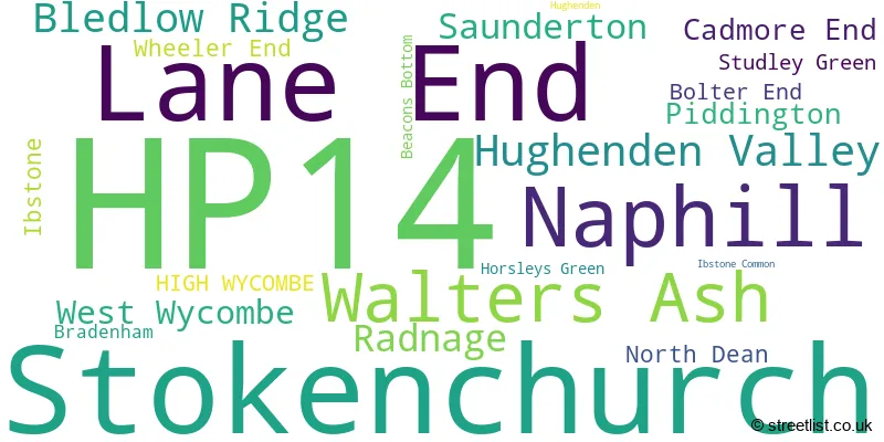
The largest settlement in the HP14 postal code is Stokenchurch followed by Lane End, and Walters Ash.
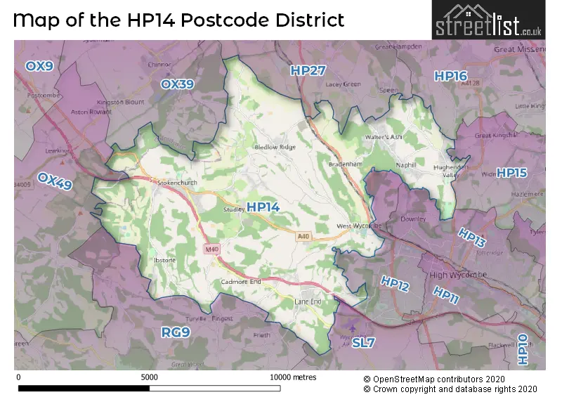
The HP14 Postcode shares a border with HP27 (PRINCES RISBOROUGH, Longwick, Monks Risborough), HP12 (HIGH WYCOMBE, Cressex Business Park, Sands Industrial Estate), HP13 (HIGH WYCOMBE, Downley), HP15 (Hazlemere, Holmer Green, Great Kingshill), SL7 (MARLOW, Medmenham, Booker), OX49 (WATLINGTON, Lewknor, Aston Rowant), RG9 (HENLEY-ON-THAMES, Hambleden, Shiplake), HP16 (Prestwood, GREAT MISSENDEN, Little Kingshill) and OX39 (CHINNOR, Kingston Blount, Sydenham).
In the HP14 postcode district, the primary settlement is High Wycombe in the county of Buckinghamshire. Other significant settlements include Beacons Bottom, Bolter End, Cadmore End, Horsleys Green, Ibstone, Ibstone Common, Lane End, Piddington, Stokenchurch, Studley Green, West Wycombe, and Wheeler End. The most significant post town in this district is High Wycombe.
For the district HP14, we have data on 2 postcode sectors. Here's a breakdown: The sector HP14 3, covers Stokenchurch and Lane End in Buckinghamshire. The sector HP14 4, covers Naphill and Walters Ash and Hughenden Valley and Bledlow Ridge and Radnage in Buckinghamshire.

Map of the HP14 Postcode District
Explore the HP14 postcode district by using our free interactive map.
When it comes to local government, postal geography often disregards political borders. However, for a breakdown in the HP14 District: the district mostly encompasses the Buckinghamshire (534 postcodes), and finally, the South Oxfordshire District area (4 postcodes).
Recent House Sales in HP14
| Date | Price | Address |
|---|---|---|
| 17/10/2023 | £580,000 | Bayley Gardens, Naphill, High Wycombe, HP14 4QW |
| 12/09/2023 | £2,230,000 | Green End Road, Radnage, High Wycombe, HP14 4BY |
| 08/09/2023 | £2,115,000 | Piddington Lane, Wheeler End, High Wycombe, HP14 3NG |
| 07/09/2023 | £210,000 | Bartholomew Tipping Way, Stokenchurch, High Wycombe, HP14 3RX |
| 01/09/2023 | £400,000 | The Row, Lane End, High Wycombe, HP14 3JR |
| 01/09/2023 | £522,000 | Allen Drive, Walters Ash, High Wycombe, HP14 4SS |
| 23/08/2023 | £265,000 | Marlow Road, Stokenchurch, High Wycombe, HP14 3QE |
| 23/08/2023 | £1,000,000 | Horsleys Green, High Wycombe, HP14 3UX |
| 17/08/2023 | £742,000 | Haw Lane, Bledlow Ridge, High Wycombe, HP14 4AH |
| 15/08/2023 | £475,000 | Marlow Road, Stokenchurch, High Wycombe, HP14 3QJ |
Weather Forecast for HP14
Press Button to Show Forecast for West Wycombe Park
| Time Period | Icon | Description | Temperature | Rain Probability | Wind |
|---|---|---|---|---|---|
| 15:00 to 18:00 | Cloudy | 10.0°C (feels like 8.0°C) | 9.00% | NW 7 mph | |
| 18:00 to 21:00 | Cloudy | 7.0°C (feels like 6.0°C) | 10.00% | NNE 7 mph | |
| 21:00 to 00:00 | Cloudy | 6.0°C (feels like 4.0°C) | 5.00% | ENE 7 mph |
Press Button to Show Forecast for West Wycombe Park
| Time Period | Icon | Description | Temperature | Rain Probability | Wind |
|---|---|---|---|---|---|
| 00:00 to 03:00 | Cloudy | 4.0°C (feels like 2.0°C) | 4.00% | ENE 4 mph | |
| 03:00 to 06:00 | Cloudy | 3.0°C (feels like 1.0°C) | 5.00% | ENE 4 mph | |
| 06:00 to 09:00 | Partly cloudy (day) | 3.0°C (feels like 0.0°C) | 2.00% | NE 7 mph | |
| 09:00 to 12:00 | Partly cloudy (day) | 7.0°C (feels like 4.0°C) | 2.00% | ENE 9 mph | |
| 12:00 to 15:00 | Overcast | 9.0°C (feels like 8.0°C) | 11.00% | ENE 7 mph | |
| 15:00 to 18:00 | Overcast | 10.0°C (feels like 9.0°C) | 14.00% | ENE 4 mph | |
| 18:00 to 21:00 | Cloudy | 9.0°C (feels like 8.0°C) | 12.00% | NE 4 mph | |
| 21:00 to 00:00 | Cloudy | 6.0°C (feels like 3.0°C) | 12.00% | ENE 7 mph |
Press Button to Show Forecast for West Wycombe Park
| Time Period | Icon | Description | Temperature | Rain Probability | Wind |
|---|---|---|---|---|---|
| 00:00 to 03:00 | Cloudy | 4.0°C (feels like 2.0°C) | 13.00% | ENE 7 mph | |
| 03:00 to 06:00 | Cloudy | 3.0°C (feels like 1.0°C) | 15.00% | ENE 7 mph | |
| 06:00 to 09:00 | Cloudy | 4.0°C (feels like 1.0°C) | 23.00% | ENE 9 mph | |
| 09:00 to 12:00 | Overcast | 8.0°C (feels like 5.0°C) | 21.00% | ENE 9 mph | |
| 12:00 to 15:00 | Overcast | 10.0°C (feels like 8.0°C) | 19.00% | E 9 mph | |
| 15:00 to 18:00 | Cloudy | 11.0°C (feels like 9.0°C) | 18.00% | ENE 11 mph | |
| 18:00 to 21:00 | Light rain | 10.0°C (feels like 7.0°C) | 52.00% | ENE 9 mph | |
| 21:00 to 00:00 | Light rain | 8.0°C (feels like 5.0°C) | 52.00% | NE 11 mph |
Press Button to Show Forecast for West Wycombe Park
| Time Period | Icon | Description | Temperature | Rain Probability | Wind |
|---|---|---|---|---|---|
| 00:00 to 03:00 | Heavy rain | 7.0°C (feels like 4.0°C) | 75.00% | NE 11 mph | |
| 03:00 to 06:00 | Heavy rain | 7.0°C (feels like 5.0°C) | 75.00% | NE 9 mph | |
| 06:00 to 09:00 | Light rain | 8.0°C (feels like 6.0°C) | 54.00% | ESE 7 mph | |
| 09:00 to 12:00 | Light rain shower (day) | 9.0°C (feels like 7.0°C) | 40.00% | ESE 9 mph | |
| 12:00 to 15:00 | Light rain | 11.0°C (feels like 9.0°C) | 55.00% | SSE 9 mph | |
| 15:00 to 18:00 | Light rain shower (day) | 12.0°C (feels like 9.0°C) | 41.00% | WSW 11 mph | |
| 18:00 to 21:00 | Light rain shower (day) | 10.0°C (feels like 7.0°C) | 31.00% | W 11 mph | |
| 21:00 to 00:00 | Cloudy | 8.0°C (feels like 6.0°C) | 8.00% | WSW 7 mph |
Where is the HP14 Postcode District?
The postcode district HP14 is located in the town of High Wycombe. High Wycombe is surrounded by several nearby towns, including Chinnor in the North West (4.13 miles away), Princes Risborough in the North (4.81 miles away), Marlow in the South East (5.73 miles away), Great Missenden in the North East (6.03 miles away), Watlington in the West (6.44 miles away), and Henley-on-Thames in the South (8.51 miles away). Additionally, the distance from HP14 to the center of London is approximately 32.76 miles.
The district is within the post town of HIGH WYCOMBE.
The sector has postcodes within the nation of England.
The HP14 Postcode District is in the Oxfordshire region of Berkshire, Buckinghamshire and Oxfordshire within the South East (England).
| Postcode Sector | Delivery Office |
|---|---|
| HP14 3 | High Wycombe South Postal Delivery Office |
| HP14 4 | High Wycombe South Postal Delivery Office |
| H | P | 1 | 4 | - | X | X | X |
| H | P | 1 | 4 | Space | Numeric | Letter | Letter |
Tourist Attractions within the Postcode Area
We found 2 visitor attractions within the HP14 postcode area
| West Wycombe Park |
|---|
| Historic Properties |
| Historic House / House and Garden / Palace |
| View West Wycombe Park on Google Maps |
| Hughenden Manor |
| Historic Properties |
| Historic House / House and Garden / Palace |
| View Hughenden Manor on Google Maps |
Current Monthly Rental Prices
| # Bedrooms | Min Price | Max Price | Avg Price |
|---|---|---|---|
| 1 | £825 | £825 | £825 |
| 2 | £732 | £1,900 | £1,427 |
| 3 | £1,695 | £1,695 | £1,695 |
| 4 | £1,800 | £2,350 | £2,125 |
| 5 | £4,950 | £4,950 | £4,950 |
Current House Prices
| # Bedrooms | Min Price | Max Price | Avg Price |
|---|---|---|---|
| £5,000 | £1,000,000 | £410,500 | |
| 1 | £150,000 | £259,950 | £202,488 |
| 2 | £170,000 | £799,950 | £426,610 |
| 3 | £375,000 | £800,000 | £557,734 |
| 4 | £500,000 | £1,999,950 | £904,755 |
| 5 | £600,000 | £3,500,000 | £1,726,663 |
| 6 | £1,050,000 | £2,500,000 | £1,775,000 |
| 7 | £1,500,000 | £1,500,000 | £1,500,000 |
| 8 | £3,950,000 | £3,950,000 | £3,950,000 |
Estate Agents who Operate in the HP14 District
| Logo | Name | Brand Name | Address | Contact Number | Total Properties |
|---|---|---|---|---|---|
 | Stokenchurch | Bonners & Babingtons | 1 Karenza, Wycombe Road, Stokenchurch, HP14 3DA | 01499 327020 | 16 |
 | Stokenchurch | Wye Residential | Stokenchurch | 01409 331134 | 12 |
 | Prestwood | Wye Country | 120 High Street, Prestwood, Great Missenden, Buckinghamshire, HP16 9HD | 01494 326023 | 9 |
 | Amersham | Kingshills Estate Agents South Buckinghamshire | Comet Studios De Havilland Court Penn Street Amersham HP7 0PX | 01494 939868 | 9 |
 | Princes Risborough | Michael Graham | 24 Market Square, Princes Risborough, HP27 0AN | 01844 393386 | 7 |
- Beacon's Bottom
- Bledlow Ridge
- Bolter End
- Bradenham
- Cadmore End
- Green End
- High Wycombe
- Horsleys Green
- Hughenden Valley
- Ibstone
- Lane End
- Lewknor
- Moor Common
- Naphill
- Piddington
- Radnage
- Rout's Green
- Saunderton
- Stokenchurch
- Studley Green
- The City
- Turville
- Upper North Dean
- Walter's Ash
- Waterend
- West Wycombe
- Wheeler End
| Type of Property | 2018 Average | 2018 Sales | 2017 Average | 2017 Sales | 2016 Average | 2016 Sales | 2015 Average | 2015 Sales |
|---|---|---|---|---|---|---|---|---|
| Detached | £642,763 | 80 | £671,037 | 90 | £621,224 | 86 | £562,734 | 117 |
| Semi-Detached | £437,981 | 66 | £402,615 | 86 | £405,836 | 87 | £381,878 | 92 |
| Terraced | £325,160 | 50 | £311,757 | 67 | £337,914 | 67 | £296,918 | 76 |
| Flats | £199,214 | 14 | £225,816 | 22 | £200,311 | 31 | £204,228 | 27 |