The HP15 6 postcode sector is within the county of Buckinghamshire.
Did you know? According to the 2021 Census, the HP15 6 postcode sector is home to a bustling 8,175 residents!
Given that each sector allows for 400 unique postcode combinations. Letters C, I, K, M, O and V are not allowed in the last two letters of a postcode. With 210 postcodes already in use, this leaves 190 units available.
The largest settlement in the HP15 6 postal code is Holmer Green followed by Great Kingshill, and Widmer End.
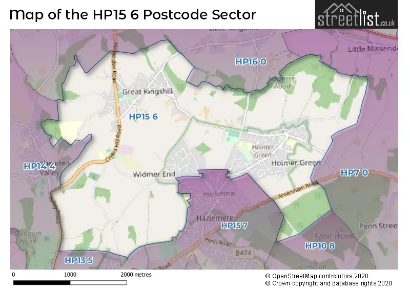
The HP15 6 Postcode shares a border with HP13 5 (HIGH WYCOMBE, Downley), HP14 4 (Walters Ash, Naphill, Hughenden Valley), HP15 7 (Hazlemere), HP16 0 (Prestwood, GREAT MISSENDEN, Little Kingshill), HP7 0 (AMERSHAM, Coleshill, Winchmore Hill) and HP10 8 (Penn).
The sector is within the post town of HIGH WYCOMBE.
HP15 6 is a postcode sector within the HP15 postcode district which is within the HP Hemel Hempstead postcode area.
The Royal Mail delivery office for the HP15 6 postal sector is the Hazlemere Delivery Office.
The area of the HP15 6 postcode sector is 5.13 square miles which is 13.29 square kilometres or 3,283.72 square acres.

Map of the HP15 6 Postcode Sector
Explore the HP15 6 postcode sector by using our free interactive map.
| H | P | 1 | 5 | - | 6 | X | X |
| H | P | 1 | 5 | Space | 6 | Letter | Letter |
Official List of Streets
Holmer Green (70 Streets)
Great Kingshill (33 Streets)
Widmer End (23 Streets)
Cryers Hill (6 Streets)
Four Ashes (1 Streets)
Unofficial Streets or Alternative Spellings
Hazlemere
AMERSHAM ROAD BRACKLEY ROAD CEDAR AVENUE GRANGE ROAD LOWER LODGE LANE ORCHARD END SAWPIT HILL WESTERN DENE BEAMOND END LANE BLUEBELL WAY GRAVELLY WAY HITCHENDEN FARM HOLLOWAY HOWE HILL LANE KINGSTREET LANE PENFOLD COTTAGES PETERLEY AVENUE RIDINGS COTTAGES RUSHMOOR PATH SHEEPCOTE COTTAGES THE HOMESTEADBeamond End
SHEEPCOTE DELL ROADHughenden Valley
BOSS LANE VALLEY ROADWeather Forecast for HP15 6
Press Button to Show Forecast for High Wycombe
| Time Period | Icon | Description | Temperature | Rain Probability | Wind |
|---|---|---|---|---|---|
| 18:00 to 21:00 | Cloudy | 8.0°C (feels like 6.0°C) | 9.00% | NNE 7 mph | |
| 21:00 to 00:00 | Cloudy | 6.0°C (feels like 4.0°C) | 5.00% | ENE 7 mph |
Press Button to Show Forecast for High Wycombe
| Time Period | Icon | Description | Temperature | Rain Probability | Wind |
|---|---|---|---|---|---|
| 00:00 to 03:00 | Cloudy | 5.0°C (feels like 3.0°C) | 5.00% | ENE 7 mph | |
| 03:00 to 06:00 | Cloudy | 4.0°C (feels like 2.0°C) | 5.00% | ENE 7 mph | |
| 06:00 to 09:00 | Cloudy | 4.0°C (feels like 1.0°C) | 4.00% | NE 7 mph | |
| 09:00 to 12:00 | Partly cloudy (day) | 7.0°C (feels like 5.0°C) | 2.00% | ENE 7 mph | |
| 12:00 to 15:00 | Overcast | 10.0°C (feels like 8.0°C) | 11.00% | ENE 7 mph | |
| 15:00 to 18:00 | Overcast | 10.0°C (feels like 9.0°C) | 14.00% | ENE 4 mph | |
| 18:00 to 21:00 | Cloudy | 9.0°C (feels like 8.0°C) | 12.00% | NE 4 mph | |
| 21:00 to 00:00 | Cloudy | 6.0°C (feels like 4.0°C) | 12.00% | ENE 7 mph |
Press Button to Show Forecast for High Wycombe
| Time Period | Icon | Description | Temperature | Rain Probability | Wind |
|---|---|---|---|---|---|
| 00:00 to 03:00 | Cloudy | 5.0°C (feels like 2.0°C) | 13.00% | ENE 7 mph | |
| 03:00 to 06:00 | Cloudy | 4.0°C (feels like 1.0°C) | 15.00% | ENE 7 mph | |
| 06:00 to 09:00 | Cloudy | 5.0°C (feels like 2.0°C) | 23.00% | ENE 9 mph | |
| 09:00 to 12:00 | Overcast | 8.0°C (feels like 5.0°C) | 21.00% | ENE 9 mph | |
| 12:00 to 15:00 | Overcast | 11.0°C (feels like 9.0°C) | 19.00% | E 9 mph | |
| 15:00 to 18:00 | Cloudy | 11.0°C (feels like 9.0°C) | 18.00% | ENE 11 mph | |
| 18:00 to 21:00 | Light rain | 10.0°C (feels like 8.0°C) | 52.00% | ENE 9 mph | |
| 21:00 to 00:00 | Light rain | 8.0°C (feels like 5.0°C) | 52.00% | NE 11 mph |
Press Button to Show Forecast for High Wycombe
| Time Period | Icon | Description | Temperature | Rain Probability | Wind |
|---|---|---|---|---|---|
| 00:00 to 03:00 | Heavy rain | 8.0°C (feels like 5.0°C) | 75.00% | NE 11 mph | |
| 03:00 to 06:00 | Heavy rain | 8.0°C (feels like 5.0°C) | 74.00% | NE 9 mph | |
| 06:00 to 09:00 | Light rain | 8.0°C (feels like 6.0°C) | 54.00% | ESE 7 mph | |
| 09:00 to 12:00 | Light rain shower (day) | 10.0°C (feels like 8.0°C) | 44.00% | ESE 9 mph | |
| 12:00 to 15:00 | Light rain | 11.0°C (feels like 9.0°C) | 56.00% | SSE 9 mph | |
| 15:00 to 18:00 | Light rain shower (day) | 12.0°C (feels like 10.0°C) | 41.00% | WSW 11 mph | |
| 18:00 to 21:00 | Light rain shower (day) | 10.0°C (feels like 8.0°C) | 31.00% | W 11 mph | |
| 21:00 to 00:00 | Cloudy | 8.0°C (feels like 6.0°C) | 8.00% | WSW 7 mph |
Schools and Places of Education Within the HP15 6 Postcode Sector
Great Kingshill Church of England Combined School
Academy converter
Cryers Hill Road, High Wycombe, Buckinghamshire, HP15 6JP
Head: Mrs Suzanne Best
Ofsted Rating: Good
Inspection: 2022-06-30 (665 days ago)
Website: Visit Great Kingshill Church of England Combined School Website
Phone: 01494713159
Number of Pupils: 420
Holmer Green First School and Pre-School
Community school
Watchet Lane, High Wycombe, Buckinghamshire, HP15 6UG
Head: Mrs Gillian Jones
Ofsted Rating: Good
Inspection: 2022-11-30 (512 days ago)
Website: Visit Holmer Green First School and Pre-School Website
Phone: 01494712050
Number of Pupils: 174
Holmer Green Junior School
Community school
The Common, High Wycombe, Buckinghamshire, HP15 6TD
Head: Mr Robin Cusdin
Ofsted Rating: Good
Inspection: 2022-10-13 (560 days ago)
Website: Visit Holmer Green Junior School Website
Phone: 01494713000
Number of Pupils: 255
Holmer Green Senior School
Academy converter
Parish Piece, High Wycombe, Buckinghamshire, HP15 6SP
Head: Mr Edward Hillyard
Ofsted Rating: Good
Inspection: 2021-12-01 (876 days ago)
Website: Visit Holmer Green Senior School Website
Phone: 01494712219
Number of Pupils: 1154
Widmer End Community Combined School
Community school
Estcourt Drive, High Wycombe, Buckinghamshire, HP15 6AH
Head: Mrs Gemma Hillier
Ofsted Rating: Good
Inspection: 2023-07-04 (296 days ago)
Website: Visit Widmer End Community Combined School Website
Phone: 01494714371
Number of Pupils: 211
House Prices in the HP15 6 Postcode Sector
| Type of Property | 2018 Average | 2018 Sales | 2017 Average | 2017 Sales | 2016 Average | 2016 Sales | 2015 Average | 2015 Sales |
|---|---|---|---|---|---|---|---|---|
| Detached | £686,591 | 49 | £649,582 | 49 | £644,913 | 55 | £526,916 | 49 |
| Semi-Detached | £443,326 | 23 | £462,100 | 41 | £428,015 | 30 | £378,533 | 35 |
| Terraced | £364,500 | 17 | £352,395 | 19 | £342,118 | 22 | £319,064 | 18 |
| Flats | £278,675 | 10 | £237,994 | 8 | £217,190 | 5 | £236,000 | 10 |
Important Postcodes HP15 6 in the Postcode Sector
HP15 6AH is the postcode for Widmer End Community Combined School, Estcourt Drive, Widmer End, and Widmer End Community Combined School, Estcourt Drive
HP15 6JP is the postcode for Great Kingshill Church Of England Combined School, Cryers Hill Road, GREAT KINGSHILL CHURCH OF ENGLAND COMBINED SCHOOL, CRYERS HILL ROAD, CRYERS HILL, Great Kingshill C of E Primary School, Cryers Hill Road, and KITCHEN BLOCK, Great Kingshill C of E Primary School, Cryers Hill Road
HP15 6SP is the postcode for Holmer Green Senior School, Parish Piece, DRAMA BUILDING, Holmer Green Senior School, Parish Piece, and MAIN BUILDING, Holmer Green Senior School, Parish Piece
HP15 6TD is the postcode for HOLMER GREEN JUNIOR SCHOOL, THE COMMON, HOLMER GREEN, and Holmer Green Junior School, The Common
HP15 6UG is the postcode for Holmer Green First School, Watchet Lane, Holmer Green, and Holmer Green First School, Watchet Lane
| The HP15 6 Sector is within these Local Authorities |
|
|---|---|
| The HP15 6 Sector is within these Counties |
|
| The HP15 6 Sector is within these Water Company Areas |
|