The HP19 postcode district is a postal district located in the HP Hemel Hempstead postcode area with a population of 27,074 residents according to the 2021 England and Wales Census.
The area of the HP19 postcode district is 2.71 square miles which is 7.03 square kilometres or 1,736.56 acres.
Currently, the HP19 district has about 606 postcode units spread across 4 geographic postcode sectors.
Given that each sector allows for 400 unique postcode combinations, the district has a capacity of 1,600 postcodes. With 606 postcodes already in use, this leaves 994 units available.
The largest settlements in the HP19 postal code are AYLESBURY and Rabans Lane Industrial Area.
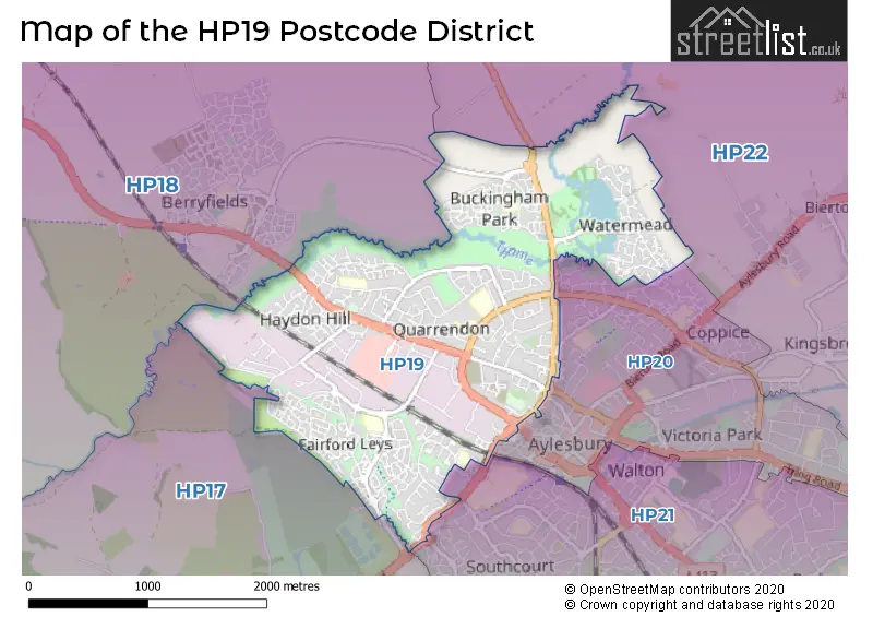
The HP19 Postcode shares a border with HP17 (Haddenham, Stone, Great Kimble), HP18 (AYLESBURY, Long Crendon, Waddesdon), HP20 (AYLESBURY), HP21 (AYLESBURY) and HP22 (Wendover, Aston Clinton, Weston Turville).
The primary settlement in the HP19 postcode district is Aylesbury, located in the county of Buckinghamshire. Aylesbury is the most significant settlement with the highest count in this postcode district. There are also other significant settlements within HP19, including Gatehouse Industrial Area and Rabans Lane Industrial Area. The primary post town for this postcode district is Aylesbury. It is important to note that the counties in the UK are referenced as "the county of [county name]," and in this case, Aylesbury is located in Buckinghamshire, which is part of England.
For the district HP19, we have data on 4 postcode sectors. Here's a breakdown: The sector HP19 0, covers Aylesbury in Buckinghamshire. The sector HP19 7, covers Aylesbury in Buckinghamshire. The sector HP19 8, covers Aylesbury in Buckinghamshire. The sector HP19 9, covers Aylesbury in Buckinghamshire.


Map of the HP19 Postcode District
Explore the HP19 postcode district by using our free interactive map.
When it comes to local government, postal geography often disregards political borders. However, for a breakdown in the HP19 District: the district mostly encompasses the Buckinghamshire area with a total of 601 postcodes.
Recent House Sales in HP19
| Date | Price | Address |
|---|---|---|
| 09/10/2023 | £287,000 | Ditchingham Close, Aylesbury, HP19 7SA |
| 29/09/2023 | £212,000 | Dove Place, Aylesbury, HP19 0GD |
| 08/09/2023 | £200,000 | Crowell Mews, Aylesbury, HP19 7HB |
| 07/09/2023 | £290,000 | Pluto Way, Weedon Hill, Aylesbury, HP19 9BH |
| 05/09/2023 | £227,000 | Irving Path, Aylesbury, HP19 8FY |
| 05/09/2023 | £150,000 | Willow Road, Aylesbury, HP19 9SY |
| 01/09/2023 | £375,000 | Parmiter Close, Aylesbury, HP19 8GS |
| 01/09/2023 | £520,000 | Woodford Close, Aylesbury, HP19 7FS |
| 31/08/2023 | £217,000 | Redcliffe Walk, Aylesbury, HP19 9LB |
| 31/08/2023 | £185,000 | Putman Street, Aylesbury, HP19 8JG |
Weather Forecast for HP19
Press Button to Show Forecast for Aylesbury
| Time Period | Icon | Description | Temperature | Rain Probability | Wind |
|---|---|---|---|---|---|
| 21:00 to 00:00 | Cloudy | 6.0°C (feels like 4.0°C) | 5.00% | ENE 4 mph |
Press Button to Show Forecast for Aylesbury
| Time Period | Icon | Description | Temperature | Rain Probability | Wind |
|---|---|---|---|---|---|
| 00:00 to 03:00 | Cloudy | 4.0°C (feels like 2.0°C) | 4.00% | ENE 7 mph | |
| 03:00 to 06:00 | Partly cloudy (night) | 3.0°C (feels like 0.0°C) | 1.00% | ENE 4 mph | |
| 06:00 to 09:00 | Partly cloudy (day) | 3.0°C (feels like 0.0°C) | 1.00% | NE 7 mph | |
| 09:00 to 12:00 | Partly cloudy (day) | 7.0°C (feels like 4.0°C) | 2.00% | ENE 9 mph | |
| 12:00 to 15:00 | Overcast | 10.0°C (feels like 8.0°C) | 10.00% | ENE 7 mph | |
| 15:00 to 18:00 | Overcast | 10.0°C (feels like 9.0°C) | 14.00% | ENE 4 mph | |
| 18:00 to 21:00 | Cloudy | 9.0°C (feels like 8.0°C) | 10.00% | NE 4 mph | |
| 21:00 to 00:00 | Cloudy | 6.0°C (feels like 4.0°C) | 12.00% | ENE 7 mph |
Press Button to Show Forecast for Aylesbury
| Time Period | Icon | Description | Temperature | Rain Probability | Wind |
|---|---|---|---|---|---|
| 00:00 to 03:00 | Cloudy | 4.0°C (feels like 2.0°C) | 12.00% | E 7 mph | |
| 03:00 to 06:00 | Cloudy | 4.0°C (feels like 1.0°C) | 14.00% | ENE 7 mph | |
| 06:00 to 09:00 | Cloudy | 5.0°C (feels like 2.0°C) | 19.00% | ENE 9 mph | |
| 09:00 to 12:00 | Overcast | 8.0°C (feels like 5.0°C) | 21.00% | ENE 9 mph | |
| 12:00 to 15:00 | Overcast | 11.0°C (feels like 8.0°C) | 18.00% | ENE 9 mph | |
| 15:00 to 18:00 | Cloudy | 11.0°C (feels like 9.0°C) | 19.00% | ENE 11 mph | |
| 18:00 to 21:00 | Light rain | 10.0°C (feels like 8.0°C) | 53.00% | ENE 11 mph | |
| 21:00 to 00:00 | Light rain | 8.0°C (feels like 5.0°C) | 53.00% | NE 13 mph |
Press Button to Show Forecast for Aylesbury
| Time Period | Icon | Description | Temperature | Rain Probability | Wind |
|---|---|---|---|---|---|
| 00:00 to 03:00 | Heavy rain | 7.0°C (feels like 4.0°C) | 76.00% | NE 11 mph | |
| 03:00 to 06:00 | Heavy rain | 8.0°C (feels like 5.0°C) | 75.00% | NE 9 mph | |
| 06:00 to 09:00 | Light rain | 8.0°C (feels like 6.0°C) | 53.00% | ESE 7 mph | |
| 09:00 to 12:00 | Light rain | 10.0°C (feels like 8.0°C) | 51.00% | ESE 9 mph | |
| 12:00 to 15:00 | Light rain shower (day) | 11.0°C (feels like 9.0°C) | 47.00% | SSE 9 mph | |
| 15:00 to 18:00 | Light rain shower (day) | 12.0°C (feels like 10.0°C) | 41.00% | WSW 11 mph | |
| 18:00 to 21:00 | Cloudy | 10.0°C (feels like 8.0°C) | 18.00% | W 11 mph | |
| 21:00 to 00:00 | Cloudy | 8.0°C (feels like 6.0°C) | 7.00% | WSW 7 mph |
Where is the HP19 Postcode District?
The data postcode district HP19 is located in Aylesbury. This district is situated in close proximity to several nearby towns. To the south of HP19 is Princes Risborough, which is approximately 7.17 miles away. Tring is positioned towards the east, around 7.42 miles away. Thame is located to the southwest of HP19, at a distance of approximately 8.63 miles. Leighton Buzzard is situated in the northeast and is approximately 9.37 miles away. Great Missenden lies to the southeast and is around 9.51 miles away. To the northwest of HP19 is Buckingham, which is approximately 12.48 miles away. Furthermore, HP19 is located at a distance of 37.31 miles from the center of London.
The district is within the post town of AYLESBURY.
The sector has postcodes within the nation of England.
The HP19 Postcode District is in the region of within the .
| Postcode Sector | Delivery Office |
|---|---|
| HP19 0 | Aylesbury Delivery Office |
| HP19 7 | Aylesbury Delivery Office |
| HP19 8 | Aylesbury Delivery Office |
| HP19 9 | Aylesbury Delivery Office |
| H | P | 1 | 9 | - | X | X | X |
| H | P | 1 | 9 | Space | Numeric | Letter | Letter |
Current Monthly Rental Prices
| # Bedrooms | Min Price | Max Price | Avg Price |
|---|---|---|---|
| 1 | £625 | £1,100 | £880 |
| 2 | £1,000 | £1,250 | £1,161 |
| 3 | £1,300 | £1,900 | £1,571 |
| 4 | £1,850 | £1,850 | £1,850 |
Current House Prices
| # Bedrooms | Min Price | Max Price | Avg Price |
|---|---|---|---|
| £7,500 | £110,000 | £75,833 | |
| 1 | £74,000 | £230,000 | £160,605 |
| 2 | £108,000 | £360,000 | £239,516 |
| 3 | £175,000 | £475,000 | £347,700 |
| 4 | £400,000 | £850,000 | £535,625 |
| 5 | £440,000 | £750,000 | £582,222 |
Estate Agents who Operate in the HP19 District
| Logo | Name | Brand Name | Address | Contact Number | Total Properties |
|---|---|---|---|---|---|
 | Aylesbury | Michael Anthony | 54 Kingsbury, Aylesbury, HP20 2JE | 01296 254926 | 28 |
 | Fairford Leys | Connells | 6 Hampden Square, Aylesbury, HP19 7HT | 01296 254946 | 23 |
 | Aylesbury | Connells | 2 Temple Street, Aylesbury, Buckinghamshire, HP20 2RH | 01296 254910 | 22 |
 | Aylesbury | George David & Co | 46 High Street, Aylesbury, Buckinghamshire, HP20 1SE | 01296 254921 | 22 |
 | Aylesbury | Chancellors | 13 Market Square, Aylesbury, HP20 1TB | 01296 254909 | 17 |
| Type of Property | 2018 Average | 2018 Sales | 2017 Average | 2017 Sales | 2016 Average | 2016 Sales | 2015 Average | 2015 Sales |
|---|---|---|---|---|---|---|---|---|
| Detached | £382,491 | 62 | £392,886 | 73 | £396,799 | 86 | £348,398 | 94 |
| Semi-Detached | £282,362 | 125 | £291,013 | 129 | £273,301 | 142 | £247,436 | 155 |
| Terraced | £266,806 | 160 | £271,576 | 201 | £256,373 | 241 | £228,678 | 330 |
| Flats | £187,216 | 126 | £188,640 | 142 | £168,160 | 169 | £142,897 | 163 |