The HP2 postcode district is a postal district located in the HP Hemel Hempstead postcode area with a population of 42,424 residents according to the 2021 England and Wales Census.
The area of the HP2 postcode district is 10.97 square miles which is 28.41 square kilometres or 7,020.19 acres.
Currently, the HP2 district has about 952 postcode units spread across 17 geographic postcode sectors.
Given that each sector allows for 400 unique postcode combinations, the district has a capacity of 6,800 postcodes. With 952 postcodes already in use, this leaves 5848 units available.
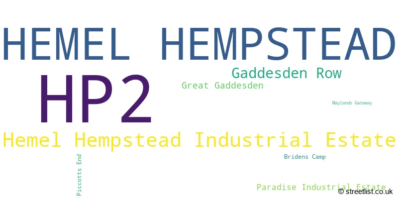
The largest settlement in the HP2 postal code is HEMEL HEMPSTEAD followed by Hemel Hempstead Industrial Estate, and Gaddesden Row.
The HP2 Postcode shares a border with AL3 (ST. ALBANS, Redbourn, Markyate), LU6 (DUNSTABLE, Eaton Bray, Edlesborough), HP1 (HEMEL HEMPSTEAD, Great Gaddesden, Water End) and HP3 (HEMEL HEMPSTEAD, BOVINGDON, Felden).
In the HP2 postcode district, the primary settlement is Hemel Hempstead, which is located in the county of Hertfordshire in England. The most significant postal town within this district is also Hemel Hempstead. Other significant settlements in this district include Hemel Hempstead Industrial Estate, Maylands Gateway, Paradise Industrial Estate, Bridens Camp, Gaddesden Row, Great Gaddesden, and Piccotts End.
For the district HP2, we have data on 4 postcode sectors. Here's a breakdown: The sector HP2 4, covers Hemel Hempstead in Hertfordshire. The sector HP2 5, covers Hemel Hempstead in Hertfordshire. The sector HP2 6, covers Hemel Hempstead and Gaddesden Row in Hertfordshire. The sector HP2 7, covers Hemel Hempstead and Hemel Hempstead Industrial Estate in Hertfordshire.

Map of the HP2 Postcode District
Explore the HP2 postcode district by using our free interactive map.
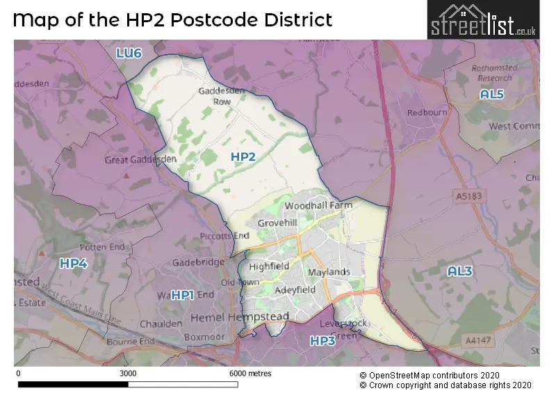
When it comes to local government, postal geography often disregards political borders. However, for a breakdown in the HP2 District: the district mostly encompasses the Dacorum District (B) (958 postcodes), and finally, the St. Albans District (B) area (8 postcodes).
Recent House Sales in HP2
| Date | Price | Address |
|---|---|---|
| 20/10/2023 | £240,000 | Selden Hill, Hemel Hempstead, HP2 4FS |
| 13/10/2023 | £260,000 | Selden Hill, Hemel Hempstead, HP2 4FA |
| 05/10/2023 | £485,000 | Adeyfield Gardens, Hemel Hempstead, HP2 5JX |
| 05/10/2023 | £490,000 | Half Moon Meadow, Hemel Hempstead, HP2 7SD |
| 29/09/2023 | £383,000 | Knightsbridge Way, Hemel Hempstead, HP2 5ES |
| 12/09/2023 | £525,000 | Ellingham Road, Hemel Hempstead, HP2 5LE |
| 05/09/2023 | £370,000 | Elstree Road, Hemel Hempstead, HP2 7NE |
| 04/09/2023 | £210,000 | Nightingale Walk, Hemel Hempstead, HP2 7QX |
| 04/09/2023 | £340,000 | Tattershall Drive, Hemel Hempstead, HP2 7QE |
| 30/08/2023 | £400,000 | Lomond Road, Hemel Hempstead, HP2 6PB |
Weather Forecast for HP2
Press Button to Show Forecast for Hemel Hempstead
| Time Period | Icon | Description | Temperature | Rain Probability | Wind |
|---|---|---|---|---|---|
| 15:00 to 18:00 | Cloudy | 10.0°C (feels like 8.0°C) | 4.00% | N 11 mph | |
| 18:00 to 21:00 | Cloudy | 9.0°C (feels like 6.0°C) | 4.00% | NNE 11 mph | |
| 21:00 to 00:00 | Partly cloudy (night) | 6.0°C (feels like 3.0°C) | 1.00% | NNE 7 mph |
Press Button to Show Forecast for Hemel Hempstead
| Time Period | Icon | Description | Temperature | Rain Probability | Wind |
|---|---|---|---|---|---|
| 00:00 to 03:00 | Clear night | 5.0°C (feels like 2.0°C) | 0.00% | N 7 mph | |
| 03:00 to 06:00 | Cloudy | 3.0°C (feels like 0.0°C) | 4.00% | N 7 mph | |
| 06:00 to 09:00 | Cloudy | 4.0°C (feels like 1.0°C) | 4.00% | N 9 mph | |
| 09:00 to 12:00 | Partly cloudy (day) | 7.0°C (feels like 4.0°C) | 1.00% | NNE 13 mph | |
| 12:00 to 15:00 | Cloudy | 10.0°C (feels like 7.0°C) | 4.00% | NNE 11 mph | |
| 15:00 to 18:00 | Cloudy | 11.0°C (feels like 8.0°C) | 3.00% | NNE 11 mph | |
| 18:00 to 21:00 | Sunny day | 9.0°C (feels like 6.0°C) | 0.00% | NNE 11 mph | |
| 21:00 to 00:00 | Clear night | 6.0°C (feels like 3.0°C) | 0.00% | NNE 9 mph |
Press Button to Show Forecast for Hemel Hempstead
| Time Period | Icon | Description | Temperature | Rain Probability | Wind |
|---|---|---|---|---|---|
| 00:00 to 03:00 | Clear night | 3.0°C (feels like 1.0°C) | 1.00% | NNE 7 mph | |
| 03:00 to 06:00 | Clear night | 3.0°C (feels like 0.0°C) | 1.00% | N 7 mph | |
| 06:00 to 09:00 | Cloudy | 3.0°C (feels like 0.0°C) | 8.00% | NNW 7 mph | |
| 09:00 to 12:00 | Overcast | 7.0°C (feels like 4.0°C) | 10.00% | N 7 mph | |
| 12:00 to 15:00 | Overcast | 8.0°C (feels like 6.0°C) | 18.00% | NNW 7 mph | |
| 15:00 to 18:00 | Overcast | 8.0°C (feels like 6.0°C) | 23.00% | NW 7 mph | |
| 18:00 to 21:00 | Light rain | 7.0°C (feels like 5.0°C) | 45.00% | NW 7 mph | |
| 21:00 to 00:00 | Overcast | 6.0°C (feels like 4.0°C) | 18.00% | N 7 mph |
Press Button to Show Forecast for Hemel Hempstead
| Time Period | Icon | Description | Temperature | Rain Probability | Wind |
|---|---|---|---|---|---|
| 00:00 to 03:00 | Light rain | 6.0°C (feels like 4.0°C) | 42.00% | N 7 mph | |
| 03:00 to 06:00 | Cloudy | 5.0°C (feels like 3.0°C) | 11.00% | N 7 mph | |
| 06:00 to 09:00 | Overcast | 5.0°C (feels like 2.0°C) | 13.00% | N 7 mph | |
| 09:00 to 12:00 | Overcast | 7.0°C (feels like 4.0°C) | 11.00% | NNW 9 mph | |
| 12:00 to 15:00 | Overcast | 8.0°C (feels like 6.0°C) | 11.00% | NNW 9 mph | |
| 15:00 to 18:00 | Overcast | 9.0°C (feels like 7.0°C) | 11.00% | N 9 mph | |
| 18:00 to 21:00 | Cloudy | 8.0°C (feels like 6.0°C) | 8.00% | N 11 mph | |
| 21:00 to 00:00 | Cloudy | 6.0°C (feels like 3.0°C) | 8.00% | N 9 mph |
Press Button to Show Forecast for Hemel Hempstead
| Time Period | Icon | Description | Temperature | Rain Probability | Wind |
|---|---|---|---|---|---|
| 00:00 to 03:00 | Cloudy | 4.0°C (feels like 2.0°C) | 6.00% | NNW 7 mph | |
| 03:00 to 06:00 | Overcast | 4.0°C (feels like 1.0°C) | 9.00% | NNW 9 mph | |
| 06:00 to 09:00 | Overcast | 4.0°C (feels like 1.0°C) | 8.00% | NW 9 mph | |
| 09:00 to 12:00 | Overcast | 7.0°C (feels like 4.0°C) | 10.00% | NNW 11 mph | |
| 12:00 to 15:00 | Light rain | 9.0°C (feels like 6.0°C) | 40.00% | NNW 11 mph | |
| 15:00 to 18:00 | Cloudy | 9.0°C (feels like 7.0°C) | 16.00% | NNW 11 mph | |
| 18:00 to 21:00 | Partly cloudy (day) | 9.0°C (feels like 6.0°C) | 4.00% | N 9 mph | |
| 21:00 to 00:00 | Cloudy | 6.0°C (feels like 4.0°C) | 5.00% | N 7 mph |
Where is the HP2 Postcode District?
The postcode district HP2 is located in Hemel Hempstead. Hemel Hempstead is nearby the towns of Apsley, Pimlico, and Felden. Additionally, Hemel Hempstead is approximately 23.56 miles away from the centre of London.
The district is within the post town of HEMEL HEMPSTEAD.
The sector has postcodes within the nation of England.
The HP2 Postcode District is in the Hertfordshire region of Bedfordshire and Hertfordshire within the East of England.
Postcode Sectors within the HP2 District
| Postcode Sector | Delivery Office |
|---|---|
| HP2 4 | Hemel Hempstead Delivery Office |
| HP2 5 | Hemel Hempstead Delivery Office |
| HP2 6 | Hemel Hempstead Delivery Office |
| HP2 7 | Hemel Hempstead Delivery Office |
| H | P | 2 | - | X | X | X |
| H | P | 2 | Space | Numeric | Letter | Letter |
Current Monthly Rental Prices
| # Bedrooms | Min Price | Max Price | Avg Price |
|---|---|---|---|
| £797 | £925 | £899 | |
| 1 | £925 | £1,750 | £1,163 |
| 2 | £900 | £1,550 | £1,300 |
| 3 | £1,495 | £2,500 | £1,928 |
| 4 | £2,000 | £2,400 | £2,200 |
| 5 | £2,250 | £2,500 | £2,375 |
Current House Prices
| # Bedrooms | Min Price | Max Price | Avg Price |
|---|---|---|---|
| £9,000 | £2,500,000 | £520,800 | |
| 1 | £80,000 | £278,000 | £189,160 |
| 2 | £75,250 | £475,000 | £278,243 |
| 3 | £240,000 | £775,000 | £442,900 |
| 4 | £350,000 | £1,150,000 | £604,472 |
| 5 | £425,000 | £1,795,000 | £688,636 |
| 6 | £850,000 | £2,000,000 | £1,233,333 |
Estate Agents who Operate in the HP2 District
| Logo | Name | Brand Name | Address | Contact Number | Total Properties |
|---|---|---|---|---|---|
 | Boxmoor | David Doyle Estate Agents | 45 St. Johns Road, Hemel Hempstead, HP1 1QQ | 01442 504076 | 57 |
 | Hemel Hempstead | Brown & Merry | 57 Marlowes Hemel Hempstead HP1 1LE | 01442 501568 | 40 |
 | Hemel Hempstead | Connells | 45 Marlowes, Hemel Hempstead, HP1 1LD | 01442 504014 | 27 |
 | Hemel Hempstead | Clements Estate Agents | 45 Marlowes Hemel Hempstead HP1 1LD | 01442 502890 | 22 |
 | Hemel Hempstead | Castles Estate Agents | 33 St Johns Road Boxmoor Hemel Hempstead Hertfordshire HP1 1QQ | 01442 504231 | 22 |
| Type of Property | 2018 Average | 2018 Sales | 2017 Average | 2017 Sales | 2016 Average | 2016 Sales | 2015 Average | 2015 Sales |
|---|---|---|---|---|---|---|---|---|
| Detached | £517,886 | 81 | £581,576 | 68 | £480,757 | 60 | £480,673 | 62 |
| Semi-Detached | £385,825 | 121 | £390,248 | 100 | £366,558 | 127 | £330,015 | 88 |
| Terraced | £324,220 | 258 | £328,511 | 246 | £310,017 | 255 | £268,637 | 258 |
| Flats | £203,134 | 202 | £212,700 | 181 | £198,781 | 206 | £167,955 | 228 |
Hotels within the Postcode Area
We found 1 hotels and guest houses within the HP2 postcode area
Holiday Inn Hemel Hempstead M1, Jct. 8
Breakspear Way, Hemel Hempstead, hemel-hempstead, HP2 4UA.
View details