The HP21 9 postcode sector is within the county of Buckinghamshire.
Did you know? According to the 2021 Census, the HP21 9 postcode sector is home to a bustling 12,451 residents!
Given that each sector allows for 400 unique postcode combinations. Letters C, I, K, M, O and V are not allowed in the last two letters of a postcode. With 252 postcodes already in use, this leaves 148 units available.
The HP21 9 postal code covers the settlement of AYLESBURY.
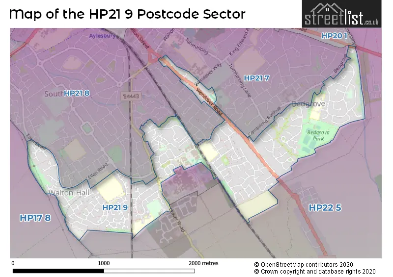
The HP21 9 Postcode shares a border with HP17 8 (Haddenham, Stone, Dinton), HP20 1 (AYLESBURY), HP21 7 (AYLESBURY), HP21 8 (AYLESBURY) and HP22 5 (Aston Clinton, Weston Turville, Stoke Mandeville).
The sector is within the post town of AYLESBURY.
HP21 9 is a postcode sector within the HP21 postcode district which is within the HP Hemel Hempstead postcode area.
The Royal Mail delivery office for the HP21 9 postal sector is the Aylesbury Delivery Office.
The area of the HP21 9 postcode sector is 0.93 square miles which is 2.41 square kilometres or 596.44 square acres.

Map of the HP21 9 Postcode Sector
Explore the HP21 9 postcode sector by using our free interactive map.
| H | P | 2 | 1 | - | 9 | X | X |
| H | P | 2 | 1 | Space | 9 | Letter | Letter |
Official List of Streets
AYLESBURY (190 Streets)
Unofficial Streets or Alternative Spellings
AYLESBURY
ALWIN CLOSE BEDGROVE BISHOPS WALK BLENHEIM PLACE CAMBORNE AVENUE CARLYLE AVENUE CHAUCER DRIVE CHURCHILL AVENUE CORNBROOK ROAD CRESWICK MEADOW ELLEN ROAD ELM FARM ROAD HANNON ROAD HARDY CLOSE LINDEN END LONG MEADOW LYNWOOD ROAD MILTON ROAD ORMESBY CLOSE ORWELL CLOSE SPENSER ROAD STOKE ROAD TRING ROAD WALTON DENE WENDOVER WAYWeston Turville
ASTON CLINTON ROAD AMBER WAY ATHENS DRIVE BRADDENHAM WALK BROUGHTON LANE BUTT CLOSE GRASSMERE GWENDOLYN BUCK DRIVE JENNER ROAD KILNER ROAD LOWMAN WAY ROUND AYLESBURY WALK SOUTH EAST AYLESBURY LINK ROAD THORPE CLOSE WELLAND CLOSE WOTTEN PATHStoke Mandeville
LOWER ROAD WENDOVER ROADWeather Forecast for HP21 9
Press Button to Show Forecast for Aylesbury
| Time Period | Icon | Description | Temperature | Rain Probability | Wind |
|---|---|---|---|---|---|
| 03:00 to 06:00 | Partly cloudy (night) | 3.0°C (feels like 0.0°C) | 1.00% | NNW 7 mph | |
| 06:00 to 09:00 | Partly cloudy (day) | 3.0°C (feels like 1.0°C) | 0.00% | NNW 7 mph | |
| 09:00 to 12:00 | Cloudy | 8.0°C (feels like 4.0°C) | 3.00% | N 11 mph | |
| 12:00 to 15:00 | Cloudy | 10.0°C (feels like 7.0°C) | 5.00% | N 11 mph | |
| 15:00 to 18:00 | Overcast | 10.0°C (feels like 8.0°C) | 7.00% | N 11 mph | |
| 18:00 to 21:00 | Cloudy | 9.0°C (feels like 7.0°C) | 4.00% | N 9 mph | |
| 21:00 to 00:00 | Cloudy | 6.0°C (feels like 5.0°C) | 4.00% | NE 4 mph |
Press Button to Show Forecast for Aylesbury
| Time Period | Icon | Description | Temperature | Rain Probability | Wind |
|---|---|---|---|---|---|
| 00:00 to 03:00 | Partly cloudy (night) | 5.0°C (feels like 3.0°C) | 2.00% | NNE 4 mph | |
| 03:00 to 06:00 | Overcast | 5.0°C (feels like 2.0°C) | 8.00% | N 4 mph | |
| 06:00 to 09:00 | Overcast | 5.0°C (feels like 2.0°C) | 8.00% | N 7 mph | |
| 09:00 to 12:00 | Overcast | 7.0°C (feels like 4.0°C) | 10.00% | NNE 11 mph | |
| 12:00 to 15:00 | Overcast | 9.0°C (feels like 6.0°C) | 10.00% | NNE 11 mph | |
| 15:00 to 18:00 | Overcast | 10.0°C (feels like 7.0°C) | 10.00% | NNE 11 mph | |
| 18:00 to 21:00 | Partly cloudy (day) | 8.0°C (feels like 6.0°C) | 3.00% | NNE 9 mph | |
| 21:00 to 00:00 | Clear night | 6.0°C (feels like 3.0°C) | 2.00% | NE 9 mph |
Press Button to Show Forecast for Aylesbury
| Time Period | Icon | Description | Temperature | Rain Probability | Wind |
|---|---|---|---|---|---|
| 00:00 to 03:00 | Partly cloudy (night) | 4.0°C (feels like 1.0°C) | 3.00% | NNE 7 mph | |
| 03:00 to 06:00 | Cloudy | 3.0°C (feels like 1.0°C) | 6.00% | N 4 mph | |
| 06:00 to 09:00 | Cloudy | 4.0°C (feels like 2.0°C) | 8.00% | N 4 mph | |
| 09:00 to 12:00 | Cloudy | 7.0°C (feels like 5.0°C) | 11.00% | N 7 mph | |
| 12:00 to 15:00 | Overcast | 8.0°C (feels like 7.0°C) | 18.00% | NNE 7 mph | |
| 15:00 to 18:00 | Overcast | 9.0°C (feels like 7.0°C) | 21.00% | NNW 7 mph | |
| 18:00 to 21:00 | Light rain | 8.0°C (feels like 6.0°C) | 44.00% | NNW 7 mph | |
| 21:00 to 00:00 | Cloudy | 6.0°C (feels like 4.0°C) | 14.00% | N 4 mph |
Press Button to Show Forecast for Aylesbury
| Time Period | Icon | Description | Temperature | Rain Probability | Wind |
|---|---|---|---|---|---|
| 00:00 to 03:00 | Cloudy | 5.0°C (feels like 4.0°C) | 11.00% | NNE 4 mph | |
| 03:00 to 06:00 | Cloudy | 5.0°C (feels like 3.0°C) | 10.00% | NNE 4 mph | |
| 06:00 to 09:00 | Cloudy | 5.0°C (feels like 3.0°C) | 11.00% | NNE 7 mph | |
| 09:00 to 12:00 | Overcast | 8.0°C (feels like 6.0°C) | 12.00% | NNE 9 mph | |
| 12:00 to 15:00 | Overcast | 10.0°C (feels like 8.0°C) | 11.00% | N 9 mph | |
| 15:00 to 18:00 | Overcast | 11.0°C (feels like 9.0°C) | 11.00% | N 9 mph | |
| 18:00 to 21:00 | Cloudy | 10.0°C (feels like 8.0°C) | 7.00% | NNE 9 mph | |
| 21:00 to 00:00 | Partly cloudy (night) | 7.0°C (feels like 5.0°C) | 3.00% | NNE 7 mph |
Schools and Places of Education Within the HP21 9 Postcode Sector
Bedgrove Infant School
Foundation school
Ingram Avenue, Aylesbury, Buckinghamshire, HP21 9DJ
Head: Miss Julie Lawrence
Ofsted Rating: Outstanding
Inspection: 2013-06-14 (3963 days ago)
Website: Visit Bedgrove Infant School Website
Phone: 01296481353
Number of Pupils: 459
Bedgrove Junior School
Academy converter
Ingram Avenue, Aylesbury, Buckinghamshire, HP21 9DN
Head: Mr Harrison Hillier
Ofsted Rating: Good
Inspection: 2023-06-14 (311 days ago)
Website: Visit Bedgrove Junior School Website
Phone: 01296487973
Number of Pupils: 486
Booker Park Community School
Community special school
Stoke Leys Close, Aylesbury, Buckinghamshire, HP21 9ET
Head: Mr Bradley Taylor
Ofsted Rating: Good
Inspection: 2022-06-30 (660 days ago)
Website: Visit Booker Park Community School Website
Phone: 01296427221
Number of Pupils: 238
William Harding School
Community school
Hazlehurst Drive, Aylesbury, Buckinghamshire, HP21 9TJ
Head: Miss Trudy Cotchin
Ofsted Rating: Good
Inspection: 2022-06-08 (682 days ago)
Website: Visit William Harding School Website
Phone: 01296421733
Number of Pupils: 821
House Prices in the HP21 9 Postcode Sector
| Type of Property | 2018 Average | 2018 Sales | 2017 Average | 2017 Sales | 2016 Average | 2016 Sales | 2015 Average | 2015 Sales |
|---|---|---|---|---|---|---|---|---|
| Detached | £451,874 | 68 | £469,156 | 25 | £504,932 | 33 | £449,739 | 23 |
| Semi-Detached | £303,351 | 91 | £334,484 | 59 | £316,056 | 57 | £286,589 | 66 |
| Terraced | £272,073 | 88 | £278,324 | 74 | £254,407 | 81 | £225,739 | 111 |
| Flats | £174,439 | 32 | £173,933 | 35 | £157,994 | 34 | £152,710 | 54 |
Important Postcodes HP21 9 in the Postcode Sector
HP21 9AU is the postcode for Bedgrove House, Hancock Close, Walton House, Hancock Close, and Oakfield House, Hancock Close
HP21 9DJ is the postcode for BLOCK 7, Bedgrove Infant School, Ingram Avenue, BLOCK 6, Bedgrove Infant School, Ingram Avenue, BLOCK 4, Bedgrove Infant School, Ingram Avenue, BLOCK 3, Bedgrove Infant School, Ingram Avenue, and BLOCK 1, Bedgrove Infant School, Ingram Avenue
HP21 9DN is the postcode for Bedgrove Junior School, Ingram Avenue, and BEDGROVE JUNIOR SCHOOL, INGRAM AVENUE, AYLESBURY
HP21 9ET is the postcode for Booker School, Stoke Leys Close, and Booker Park School, Stoke Leys Close
HP21 9PP is the postcode for DORMS & CONFERENCE CENTRE, British Wheelchair Sports Foundation, Stoke Mandeville Sports Stadium, Harvey Road, GUTTMANN CENTRE, British Wheelchair Sports Foundation, Stoke Mandeville Sports Stadium, Harvey Road, OLYMPIC LODGE, British Wheelchair Sports Foundation, Stoke Mandeville Sports Stadium, Harvey Road, THE BOWLS BUILDING, British Wheelchair Sports Foundation, Stoke Mandeville Sports Stadium, Harvey Road, and British Wheelchair Sports Foundation, Stoke Mandeville Sports Stadium, Harvey Road
HP21 9TJ is the postcode for JUNIOR SCHOOL, William Harding Combined School, Hazlehurst Drive, MAIN BUILDING, William Harding Combined School, Hazlehurst Drive, and INFANT SITE, William Harding Combined School, Hazlehurst Drive
HP21 9YL is the postcode for Hawkslade Community Centre, Barley Crescent
| The HP21 9 Sector is within these Local Authorities |
|
|---|---|
| The HP21 9 Sector is within these Counties |
|
| The HP21 9 Sector is within these Water Company Areas |
|