The HP8 postcode district is a postal district located in the HP Hemel Hempstead postcode area with a population of 6,934 residents according to the 2021 England and Wales Census.
The area of the HP8 postcode district is 7.27 square miles which is 18.82 square kilometres or 4,650.92 acres.
Currently, the HP8 district has about 217 postcode units spread across 1 geographic postcode sectors.
Given that each sector allows for 400 unique postcode combinations, the district has a capacity of 400 postcodes. With 217 postcodes already in use, this leaves 183 units available.
The largest settlement in the HP8 postal code is CHALFONT ST. GILES followed by CHALFONT ST GILES, and LITTLE CHALFONT.
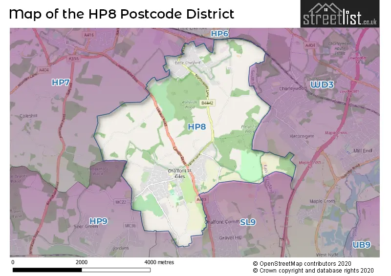
The HP8 Postcode shares a border with HP7 (AMERSHAM, Coleshill, Winchmore Hill), HP9 (BEACONSFIELD, Seer Green, Knotty Green), SL9 (GERRARDS CROSS, CHALFONT ST PETER, Chalfont St. Peter) and WD3 (CROXLEY GREEN, RICKMANSWORTH, CHORLEYWOOD).
The primary settlement in the HP8 postcode district is Chalfont St. Giles, which is located in the county of Buckinghamshire. The most significant post town in the district is also Chalfont St. Giles. There is one additional settlement in the district, which is located in Hertfordshire.
For the district HP8, we have data on 1 postcode sectors. Here's a breakdown: The sector HP8 4, covers Chalfont St. Giles in Buckinghamshire.
HP8 Postcode Sectors

Map of the HP8 Postcode District
Explore the HP8 postcode district by using our free interactive map.
When it comes to local government, postal geography often disregards political borders. However, for a breakdown in the HP8 District: the district mostly encompasses the Buckinghamshire area with a total of 218 postcodes.
Recent House Sales in HP8
| Date | Price | Address |
|---|---|---|
| 31/08/2023 | £2,000,000 | Burtons Lane, Chalfont St Giles, HP8 4BA |
| 29/08/2023 | £519,000 | Narcot Road, Chalfont St Giles, HP8 4DE |
| 25/08/2023 | £490,000 | Fleetwood Close, Chalfont St Giles, HP8 4DR |
| 24/08/2023 | £700,000 | Horse Croft Close, Chalfont St Giles, HP8 4FJ |
| 18/08/2023 | £435,000 | Narcot Lane, Chalfont St Giles, HP8 4DA |
| 16/08/2023 | £240,000 | Seymour Road, Chalfont St Giles, HP8 4RA |
| 09/08/2023 | £240,000 | High Street, Chalfont St Giles, HP8 4QH |
| 07/08/2023 | £1,825,000 | Burtons Lane, Chalfont St Giles, HP8 4BA |
| 27/07/2023 | £1,215,000 | London Road, Chalfont St Giles, HP8 4NN |
| 27/07/2023 | £778,000 | Albion Crescent, Chalfont St Giles, HP8 4ET |
Weather Forecast for HP8
Press Button to Show Forecast for Chorleywood
| Time Period | Icon | Description | Temperature | Rain Probability | Wind |
|---|---|---|---|---|---|
| 00:00 to 03:00 | Cloudy | 5.0°C (feels like 3.0°C) | 4.00% | S 4 mph | |
| 03:00 to 06:00 | Cloudy | 4.0°C (feels like 2.0°C) | 5.00% | SSW 4 mph | |
| 06:00 to 09:00 | Cloudy | 5.0°C (feels like 3.0°C) | 5.00% | WSW 7 mph | |
| 09:00 to 12:00 | Cloudy | 8.0°C (feels like 6.0°C) | 6.00% | W 7 mph | |
| 12:00 to 15:00 | Overcast | 10.0°C (feels like 7.0°C) | 48.00% | W 11 mph | |
| 15:00 to 18:00 | Cloudy | 9.0°C (feels like 7.0°C) | 11.00% | NW 9 mph | |
| 18:00 to 21:00 | Cloudy | 7.0°C (feels like 6.0°C) | 8.00% | NNE 7 mph | |
| 21:00 to 00:00 | Cloudy | 6.0°C (feels like 4.0°C) | 7.00% | NE 4 mph |
Press Button to Show Forecast for Chorleywood
| Time Period | Icon | Description | Temperature | Rain Probability | Wind |
|---|---|---|---|---|---|
| 00:00 to 03:00 | Cloudy | 5.0°C (feels like 3.0°C) | 5.00% | NE 4 mph | |
| 03:00 to 06:00 | Cloudy | 3.0°C (feels like 1.0°C) | 4.00% | NE 4 mph | |
| 06:00 to 09:00 | Cloudy | 3.0°C (feels like 1.0°C) | 4.00% | NE 7 mph | |
| 09:00 to 12:00 | Partly cloudy (day) | 7.0°C (feels like 4.0°C) | 2.00% | ENE 7 mph | |
| 12:00 to 15:00 | Overcast | 10.0°C (feels like 8.0°C) | 10.00% | ENE 7 mph | |
| 15:00 to 18:00 | Overcast | 10.0°C (feels like 9.0°C) | 14.00% | ENE 4 mph | |
| 18:00 to 21:00 | Cloudy | 9.0°C (feels like 8.0°C) | 13.00% | ENE 7 mph | |
| 21:00 to 00:00 | Cloudy | 6.0°C (feels like 4.0°C) | 12.00% | ENE 7 mph |
Press Button to Show Forecast for Chorleywood
| Time Period | Icon | Description | Temperature | Rain Probability | Wind |
|---|---|---|---|---|---|
| 00:00 to 03:00 | Cloudy | 4.0°C (feels like 2.0°C) | 11.00% | ENE 7 mph | |
| 03:00 to 06:00 | Cloudy | 4.0°C (feels like 1.0°C) | 14.00% | ENE 7 mph | |
| 06:00 to 09:00 | Cloudy | 5.0°C (feels like 2.0°C) | 22.00% | NE 7 mph | |
| 09:00 to 12:00 | Overcast | 8.0°C (feels like 6.0°C) | 20.00% | ENE 9 mph | |
| 12:00 to 15:00 | Overcast | 11.0°C (feels like 9.0°C) | 18.00% | E 9 mph | |
| 15:00 to 18:00 | Cloudy | 11.0°C (feels like 9.0°C) | 19.00% | ENE 11 mph | |
| 18:00 to 21:00 | Light rain | 10.0°C (feels like 8.0°C) | 50.00% | ENE 9 mph | |
| 21:00 to 00:00 | Light rain | 8.0°C (feels like 5.0°C) | 54.00% | NE 11 mph |
Press Button to Show Forecast for Chorleywood
| Time Period | Icon | Description | Temperature | Rain Probability | Wind |
|---|---|---|---|---|---|
| 00:00 to 03:00 | Heavy rain | 8.0°C (feels like 5.0°C) | 75.00% | NE 11 mph | |
| 03:00 to 06:00 | Heavy rain | 8.0°C (feels like 6.0°C) | 75.00% | NE 9 mph | |
| 06:00 to 09:00 | Light rain | 8.0°C (feels like 6.0°C) | 54.00% | SE 7 mph | |
| 09:00 to 12:00 | Heavy rain | 10.0°C (feels like 8.0°C) | 75.00% | ESE 9 mph | |
| 12:00 to 15:00 | Light rain | 11.0°C (feels like 9.0°C) | 56.00% | SSE 9 mph | |
| 15:00 to 18:00 | Heavy rain shower (day) | 12.0°C (feels like 10.0°C) | 60.00% | SSW 11 mph | |
| 18:00 to 21:00 | Light rain shower (day) | 11.0°C (feels like 8.0°C) | 36.00% | WSW 11 mph | |
| 21:00 to 00:00 | Cloudy | 9.0°C (feels like 7.0°C) | 8.00% | SW 7 mph |
Where is the HP8 Postcode District?
The data shows that the postcode district HP8 is located in Chalfont St. Giles, which is a district town. Chalfont St. Giles is located in close proximity to several nearby towns, including Chalfont St. Peter in the southeast, Little Chalfont in the northeast, and Chalfont St. Giles itself in the east. Furthermore, the district is approximately 20.99 miles away from the center of London.
The district is within the post town of CHALFONT ST. GILES.
The sector has postcodes within the nation of England.
The HP8 Postcode District is in the region of within the .
Postcode Sectors within the HP8 District
| Postcode Sector | Delivery Office |
|---|---|
| HP8 4 | Amersham Delivery Office |
| H | P | 8 | - | X | X | X |
| H | P | 8 | Space | Numeric | Letter | Letter |
Current Monthly Rental Prices
| # Bedrooms | Min Price | Max Price | Avg Price |
|---|---|---|---|
| 1 | £1,100 | £1,100 | £1,100 |
| 2 | £1,450 | £2,100 | £1,663 |
Current House Prices
| # Bedrooms | Min Price | Max Price | Avg Price |
|---|---|---|---|
| £35,000 | £5,995,000 | £1,885,000 | |
| 1 | £350,000 | £449,950 | £399,975 |
| 2 | £275,000 | £850,000 | £566,944 |
| 3 | £500,000 | £1,125,000 | £774,858 |
| 4 | £819,950 | £1,650,000 | £1,105,905 |
| 5 | £1,210,000 | £2,500,000 | £1,736,429 |
| 6 | £1,470,000 | £6,500,000 | £2,567,500 |
Estate Agents who Operate in the HP8 District
| Logo | Name | Brand Name | Address | Contact Number | Total Properties |
|---|---|---|---|---|---|
 | Chalfont St Giles | The Frost Partnership | 10 High Street, Chalfont St. Giles, HP8 4QF | 01494 411765 | 22 |
 | Chalfont St Giles | Peter Scott | Deanway, Chalfont St. Giles, HP8 4JH | 01753 387464 | 10 |
 | Chalfont St Giles | Colman & Co | 3 The Green, High Street, Chalfont St. Giles, HP8 4QF | 01494 341318 | 7 |
 | Amersham | Savills | 55 Hill Avenue, Amersham, HP6 5BX | 01494 341308 | 6 |
 | Commercial & Rural Department, Maidenhead | Pike Smith & Kemp | The Granary, Hyde Farm, Marlow Road, Maidenhead, SL6 6PQ | 01628 969385 | 3 |
| Type of Property | 2018 Average | 2018 Sales | 2017 Average | 2017 Sales | 2016 Average | 2016 Sales | 2015 Average | 2015 Sales |
|---|---|---|---|---|---|---|---|---|
| Detached | £898,822 | 55 | £1,373,280 | 56 | £1,039,350 | 59 | £1,045,616 | 81 |
| Semi-Detached | £571,870 | 23 | £576,271 | 12 | £535,237 | 17 | £516,025 | 10 |
| Terraced | £483,125 | 8 | £516,663 | 12 | £511,923 | 13 | £413,763 | 18 |
| Flats | £343,333 | 3 | £583,662 | 15 | £437,079 | 12 | £247,744 | 8 |