The HP9 1 postcode sector is within the county of Buckinghamshire.
Did you know? According to the 2021 Census, the HP9 1 postcode sector is home to a bustling 9,216 residents!
Given that each sector allows for 400 unique postcode combinations. Letters C, I, K, M, O and V are not allowed in the last two letters of a postcode. With 270 postcodes already in use, this leaves 130 units available.
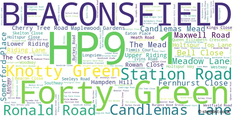
The largest settlement in the HP9 1 postal code is BEACONSFIELD followed by Knotty Green, and Forty Green.
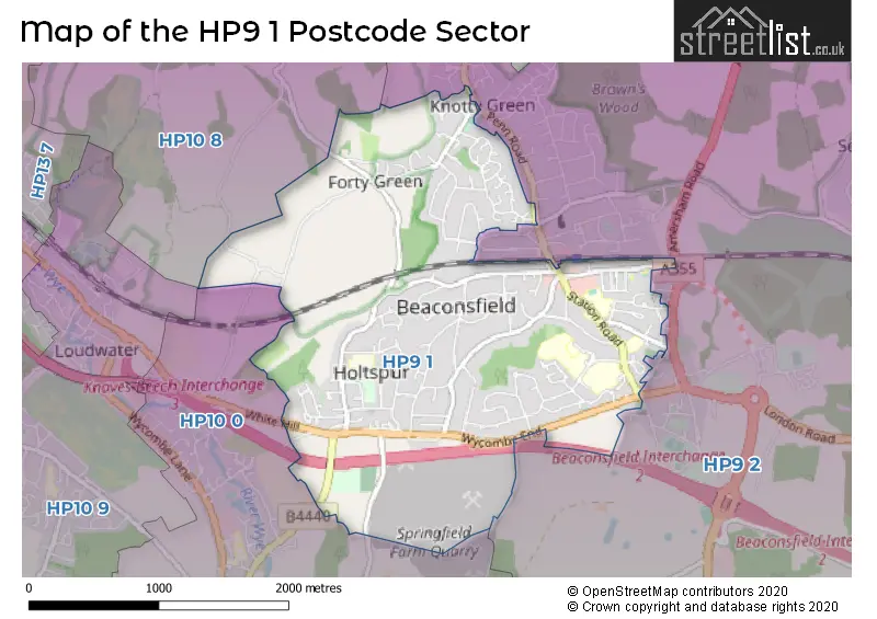
The HP9 1 Postcode shares a border with HP9 2 (BEACONSFIELD, Seer Green, Jordans), HP10 0 (Wooburn Green, Wooburn Moor, Wooburn Town) and HP10 8 (Penn).
The sector is within the post town of BEACONSFIELD.
HP9 1 is a postcode sector within the HP9 postcode district which is within the HP Hemel Hempstead postcode area.
The Royal Mail delivery office for the HP9 1 postal sector is the Beaconsfield Delivery Office.
The area of the HP9 1 postcode sector is 2.80 square miles which is 7.25 square kilometres or 1,792.06 square acres.
The HP9 1 postcode sector is crossed by the M40 motorway.

Map of the HP9 1 Postcode Sector
Explore the HP9 1 postcode sector by using our free interactive map.
| H | P | 9 | - | 1 | X | X |
| H | P | 9 | Space | 1 | Letter | Letter |
Official List of Streets
BEACONSFIELD (119 Streets)
Forty Green (5 Streets)
Unofficial Streets or Alternative Spellings
BEACONSFIELD
AMERSHAM ROAD GROVE COURT SHEPHERDS LANE THE BIRCHESKnotty Green
DAVIDGE PLACE PENN ROAD WOODCHESTER PARK CHARTWELL GATE CRAB TREE CLOSE FACTORY YARD FORTY GREEN HOLTSPUR LANE KILN COURT MAXWELL PLACE MEADOW COTTAGES MILL LANE SEELEYS WALK ST JOSEPHS MEWS WALK WOOD WALK WOOD RISE WEST WAY WHITE HILLWooburn Green
BROAD LANE HOLTSPUR LANE WHITEHOUSE LANEPenn
BAYLEYS BOTTOM GATEMOOR LANEWeather Forecast for HP9 1
Press Button to Show Forecast for Beaconsfield
| Time Period | Icon | Description | Temperature | Rain Probability | Wind |
|---|---|---|---|---|---|
| 21:00 to 00:00 | Cloudy | 6.0°C (feels like 4.0°C) | 7.00% | ENE 7 mph |
Press Button to Show Forecast for Beaconsfield
| Time Period | Icon | Description | Temperature | Rain Probability | Wind |
|---|---|---|---|---|---|
| 00:00 to 03:00 | Cloudy | 5.0°C (feels like 3.0°C) | 5.00% | ENE 7 mph | |
| 03:00 to 06:00 | Cloudy | 4.0°C (feels like 2.0°C) | 4.00% | NE 7 mph | |
| 06:00 to 09:00 | Cloudy | 4.0°C (feels like 1.0°C) | 5.00% | NE 7 mph | |
| 09:00 to 12:00 | Partly cloudy (day) | 7.0°C (feels like 5.0°C) | 3.00% | ENE 9 mph | |
| 12:00 to 15:00 | Overcast | 10.0°C (feels like 8.0°C) | 11.00% | ENE 7 mph | |
| 15:00 to 18:00 | Overcast | 10.0°C (feels like 9.0°C) | 14.00% | ENE 4 mph | |
| 18:00 to 21:00 | Cloudy | 9.0°C (feels like 8.0°C) | 13.00% | ENE 4 mph | |
| 21:00 to 00:00 | Cloudy | 6.0°C (feels like 4.0°C) | 12.00% | ENE 7 mph |
Press Button to Show Forecast for Beaconsfield
| Time Period | Icon | Description | Temperature | Rain Probability | Wind |
|---|---|---|---|---|---|
| 00:00 to 03:00 | Cloudy | 5.0°C (feels like 3.0°C) | 13.00% | ENE 7 mph | |
| 03:00 to 06:00 | Cloudy | 4.0°C (feels like 2.0°C) | 17.00% | NE 7 mph | |
| 06:00 to 09:00 | Light rain | 5.0°C (feels like 2.0°C) | 51.00% | NE 9 mph | |
| 09:00 to 12:00 | Cloudy | 8.0°C (feels like 6.0°C) | 18.00% | ENE 9 mph | |
| 12:00 to 15:00 | Overcast | 11.0°C (feels like 9.0°C) | 19.00% | E 9 mph | |
| 15:00 to 18:00 | Light rain | 12.0°C (feels like 9.0°C) | 49.00% | ENE 11 mph | |
| 18:00 to 21:00 | Cloudy | 10.0°C (feels like 8.0°C) | 22.00% | ENE 9 mph | |
| 21:00 to 00:00 | Light rain | 9.0°C (feels like 6.0°C) | 53.00% | NE 11 mph |
Press Button to Show Forecast for Beaconsfield
| Time Period | Icon | Description | Temperature | Rain Probability | Wind |
|---|---|---|---|---|---|
| 00:00 to 03:00 | Heavy rain | 8.0°C (feels like 5.0°C) | 74.00% | NE 11 mph | |
| 03:00 to 06:00 | Heavy rain | 8.0°C (feels like 6.0°C) | 78.00% | NE 9 mph | |
| 06:00 to 09:00 | Light rain | 8.0°C (feels like 6.0°C) | 54.00% | ESE 7 mph | |
| 09:00 to 12:00 | Light rain shower (day) | 10.0°C (feels like 8.0°C) | 40.00% | E 7 mph | |
| 12:00 to 15:00 | Light rain | 11.0°C (feels like 10.0°C) | 55.00% | SSE 9 mph | |
| 15:00 to 18:00 | Light rain shower (day) | 12.0°C (feels like 10.0°C) | 42.00% | WSW 11 mph | |
| 18:00 to 21:00 | Cloudy | 10.0°C (feels like 8.0°C) | 15.00% | W 11 mph | |
| 21:00 to 00:00 | Cloudy | 8.0°C (feels like 7.0°C) | 7.00% | WSW 7 mph |
Schools and Places of Education Within the HP9 1 Postcode Sector
Beaconsfield High School
Academy converter
Wattleton Road, Beaconsfield, Buckinghamshire, HP9 1RR
Head: Mr Thomas Griffiths & Mrs Joanna Holdsworth (Maternity Cover)
Ofsted Rating: Outstanding
Inspection: 2019-12-12 (1596 days ago)
Website: Visit Beaconsfield High School Website
Phone: 01494673043
Number of Pupils: 1270
Butlers Court School
Community school
Wattleton Road, Beaconsfield, Buckinghamshire, HP9 1RW
Head: Mr Stephen Butler
Ofsted Rating: Good
Inspection: 2018-06-12 (2144 days ago)
Website: Visit Butlers Court School Website
Phone: 01494673538
Number of Pupils: 415
Holtspur School & Pre-School
Community school
Cherry Tree Road, Beaconsfield, Buckinghamshire, HP9 1BH
Head: Mrs Lea McKellar
Ofsted Rating: Good
Inspection: 2023-07-12 (288 days ago)
Website: Visit Holtspur School & Pre-School Website
Phone: 01494674325
Number of Pupils: 230
St Mary and All Saints CofE Primary School
Voluntary aided school
Maxwell Road, Beaconsfield, Buckinghamshire, HP9 1RG
Head: Mrs J Barnett
Ofsted Rating: Requires improvement
Inspection: 2022-06-22 (673 days ago)
Website: Visit St Mary and All Saints CofE Primary School Website
Phone: 01494673762
Number of Pupils: 395
The Beaconsfield School
Academy converter
Wattleton Road, Beaconsfield, Buckinghamshire, HP9 1SJ
Head: Mrs Caroline Legg
Ofsted Rating: Good
Inspection: 2019-02-13 (1898 days ago)
Website: Visit The Beaconsfield School Website
Phone: 01494673450
Number of Pupils: 848
House Prices in the HP9 1 Postcode Sector
| Type of Property | 2018 Average | 2018 Sales | 2017 Average | 2017 Sales | 2016 Average | 2016 Sales | 2015 Average | 2015 Sales |
|---|---|---|---|---|---|---|---|---|
| Detached | £1,395,140 | 66 | £1,423,888 | 62 | £1,393,666 | 76 | £1,453,962 | 85 |
| Semi-Detached | £586,484 | 32 | £676,482 | 22 | £573,549 | 21 | £566,429 | 27 |
| Terraced | £673,316 | 19 | £552,999 | 18 | £540,013 | 20 | £543,931 | 21 |
| Flats | £556,143 | 21 | £435,779 | 17 | £496,976 | 21 | £680,473 | 41 |
Important Postcodes HP9 1 in the Postcode Sector
HP9 1BH is the postcode for HOLTSPUR PRIMARY SCHOOL, CHERRY TREE ROAD, BEACONSFIELD, Holtspur School, Cherry Tree Road, and Holtspur Primary School, Cherry Tree Road
HP9 1EA is the postcode for Buckinghamshire Fire & Rescue Service, Fire Station, 2 Skelton Close
HP9 1PS is the postcode for Simpson Health Centre, 70 Gregories Road
HP9 1RG is the postcode for ST MARYS AND ALL SAINTS CHURCH OF ENGLAND PRIMARY SCHOOL, MAXWELL ROAD, BEACONSFIELD, ST MARYS AND ALL SAINTS CHURCH OF ENGLAND PRIMARY SCHOOL, MAXWELL ROAD, and St. Mary & All Saints C of E Primary School, Maxwell Road
HP9 1RJ is the postcode for The Beacon Sports Centre, Holtspur Way, and The Beacon Centre, Beacon Close
HP9 1RR is the postcode for TAYLOR BUILDING, Beaconsfield High School, Wattleton Road, KINGSLEY BUILDING, Beaconsfield High School, Wattleton Road, and MAIN BUILDING, Beaconsfield High School, Wattleton Road
HP9 1RW is the postcode for Butlers Court County Combined School, Wattleton Road, YEAR 5 BLOCK, Butlers Court County Combined School, Wattleton Road, and KS1 BLOCK, Butlers Court County Combined School, Wattleton Road
HP9 1SJ is the postcode for BLOCK 1, Beaconsfield School, Wattleton Road, Beaconsfield School, Wattleton Road, BLOCK 7, Beaconsfield School, Wattleton Road, and BLOCKS 2, 3 & 4, Beaconsfield School, Wattleton Road
HP9 1TF is the postcode for Seeleys House, Campbell Drive
| The HP9 1 Sector is within these Local Authorities |
|
|---|---|
| The HP9 1 Sector is within these Counties |
|
| The HP9 1 Sector is within these Water Company Areas |
|