The HP9 2 postcode sector is within the county of Buckinghamshire.
Did you know? According to the 2021 Census, the HP9 2 postcode sector is home to a bustling 8,407 residents!
Given that each sector allows for 400 unique postcode combinations. Letters C, I, K, M, O and V are not allowed in the last two letters of a postcode. With 275 postcodes already in use, this leaves 125 units available.
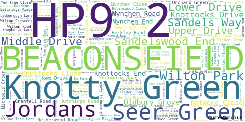
The largest settlement in the HP9 2 postal code is BEACONSFIELD followed by Seer Green, and Jordans.
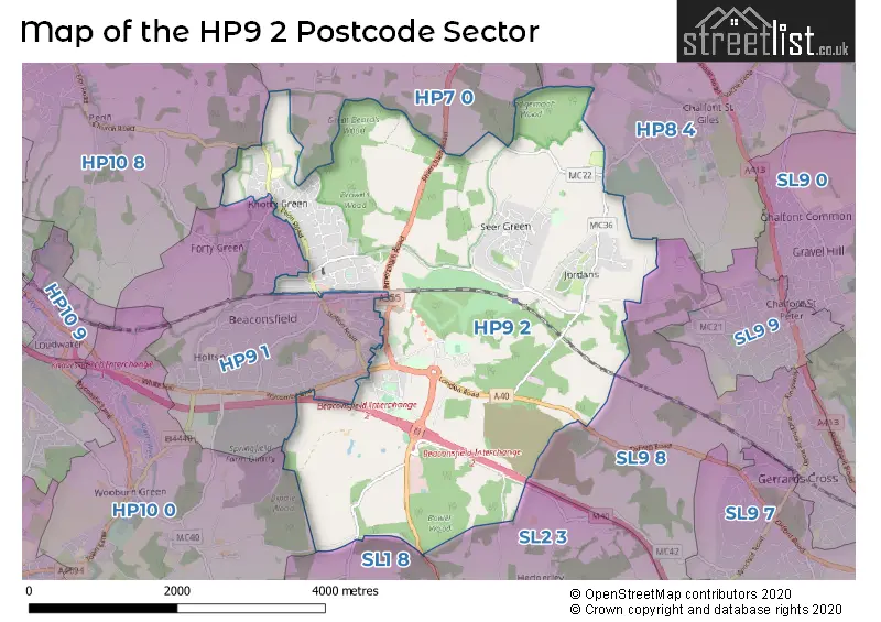
The HP9 2 Postcode shares a border with SL9 8 (GERRARDS CROSS, Chalfont St. Peter, CHALFONT ST PETER), SL1 8 (Burnham), SL2 3 (Farnham Common, Farnham Royal, Hedgerley), HP7 0 (AMERSHAM, Coleshill, Winchmore Hill), HP8 4 (CHALFONT ST. GILES, CHALFONT ST GILES, LITTLE CHALFONT), HP9 1 (BEACONSFIELD, Knotty Green, Forty Green), HP10 0 (Wooburn Green, Wooburn Moor, Wooburn Town) and HP10 8 (Penn).
The sector is within the post town of BEACONSFIELD.
HP9 2 is a postcode sector within the HP9 postcode district which is within the HP Hemel Hempstead postcode area.
The Royal Mail delivery office for the HP9 2 postal sector is the Beaconsfield Delivery Office.
The area of the HP9 2 postcode sector is 8.59 square miles which is 22.25 square kilometres or 5,499.04 square acres.
The HP9 2 postcode sector is crossed by the M40 motorway.

Map of the HP9 2 Postcode Sector
Explore the HP9 2 postcode sector by using our free interactive map.
| H | P | 9 | - | 2 | X | X |
| H | P | 9 | Space | 2 | Letter | Letter |
Official List of Streets
BEACONSFIELD (79 Streets)
Wilton Park (14 Streets)
Seer Green (41 Streets)
Jordans (20 Streets)
Knotty Green (13 Streets)
Unofficial Streets or Alternative Spellings
CHALFONT ST. GILES
THREE HOUSEHOLDS BAKERY COURT BAYNE HILL BEACONSFIELD BYPASS BEACONSFIELD COMMON LANE BEACONSFIELD EASTERN RELIEF ROAD BEACONSFIELD INTERCHANGE BEARS WOOD BOUNDARY WALK BOWL BARROW WAY CALUMET CLAY STREET CROSS LANE DORNEY HILL NORTH DORNEY HILL SOUTH DU PRE RIDE GREGORYS RIDE HYDE FARM JUBILEE RIDE KILN WAY LONDON END ROUNDABOUT LONDON ROAD MARRODS BOTTOM MILTONS RIDE MULBERRY COURT OLD LONG GROVE ORCHID WALK PARK PALE RIDE PITLANDS RIDE PYEBUSH ROUNDABOUT SANDLESWOOD GARDENS SEELEYS WALK SHIP HILL STAMPWELL WAY WALLERS RIDE WILLOW WALK WOODCRESTER PARK WOODLANDS HILLChalfont St. Peter
WELDERS LANEDenham
OXFORD ROADColeshill
BOTTRELLS LANEBEACONSFIELD
AYLESBURY END BELL CLOSE BUTLERS COURT ROAD CANDLEMAS LANE MAXWELL ROAD MEADOW LANE ORCHARD CLOSE RONALD ROAD SEELEYS ROAD STATION PARADE STATION ROAD WOODSIDE AVENUE WOODSIDE ROAD WYCOMBE ENDKnotty Green
FORTY GREEN ROADWinchmore Hill
HORSEMOOR LANEBEACONSFIELD,
HEDGERLEY LANEWooburn Green
GREEN COMMON LANEWeather Forecast for HP9 2
Press Button to Show Forecast for Beaconsfield
| Time Period | Icon | Description | Temperature | Rain Probability | Wind |
|---|---|---|---|---|---|
| 09:00 to 12:00 | Cloudy | 9.0°C (feels like 7.0°C) | 6.00% | W 7 mph | |
| 12:00 to 15:00 | Cloudy | 10.0°C (feels like 8.0°C) | 34.00% | W 11 mph | |
| 15:00 to 18:00 | Cloudy | 10.0°C (feels like 8.0°C) | 13.00% | WNW 7 mph | |
| 18:00 to 21:00 | Cloudy | 8.0°C (feels like 6.0°C) | 8.00% | N 7 mph | |
| 21:00 to 00:00 | Cloudy | 6.0°C (feels like 4.0°C) | 7.00% | ENE 7 mph |
Press Button to Show Forecast for Beaconsfield
| Time Period | Icon | Description | Temperature | Rain Probability | Wind |
|---|---|---|---|---|---|
| 00:00 to 03:00 | Cloudy | 5.0°C (feels like 3.0°C) | 5.00% | ENE 7 mph | |
| 03:00 to 06:00 | Cloudy | 4.0°C (feels like 2.0°C) | 4.00% | NE 7 mph | |
| 06:00 to 09:00 | Cloudy | 4.0°C (feels like 1.0°C) | 5.00% | NE 7 mph | |
| 09:00 to 12:00 | Partly cloudy (day) | 7.0°C (feels like 5.0°C) | 3.00% | ENE 9 mph | |
| 12:00 to 15:00 | Overcast | 10.0°C (feels like 8.0°C) | 11.00% | ENE 7 mph | |
| 15:00 to 18:00 | Overcast | 10.0°C (feels like 9.0°C) | 14.00% | ENE 4 mph | |
| 18:00 to 21:00 | Cloudy | 9.0°C (feels like 8.0°C) | 13.00% | ENE 4 mph | |
| 21:00 to 00:00 | Cloudy | 6.0°C (feels like 4.0°C) | 12.00% | ENE 7 mph |
Press Button to Show Forecast for Beaconsfield
| Time Period | Icon | Description | Temperature | Rain Probability | Wind |
|---|---|---|---|---|---|
| 00:00 to 03:00 | Cloudy | 5.0°C (feels like 3.0°C) | 13.00% | ENE 7 mph | |
| 03:00 to 06:00 | Cloudy | 4.0°C (feels like 2.0°C) | 17.00% | NE 7 mph | |
| 06:00 to 09:00 | Light rain | 5.0°C (feels like 2.0°C) | 51.00% | NE 9 mph | |
| 09:00 to 12:00 | Cloudy | 8.0°C (feels like 6.0°C) | 18.00% | ENE 9 mph | |
| 12:00 to 15:00 | Overcast | 11.0°C (feels like 9.0°C) | 19.00% | E 9 mph | |
| 15:00 to 18:00 | Light rain | 12.0°C (feels like 9.0°C) | 49.00% | ENE 11 mph | |
| 18:00 to 21:00 | Cloudy | 10.0°C (feels like 8.0°C) | 22.00% | ENE 9 mph | |
| 21:00 to 00:00 | Light rain | 9.0°C (feels like 6.0°C) | 53.00% | NE 11 mph |
Press Button to Show Forecast for Beaconsfield
| Time Period | Icon | Description | Temperature | Rain Probability | Wind |
|---|---|---|---|---|---|
| 00:00 to 03:00 | Heavy rain | 8.0°C (feels like 5.0°C) | 74.00% | NE 11 mph | |
| 03:00 to 06:00 | Heavy rain | 8.0°C (feels like 6.0°C) | 78.00% | NE 9 mph | |
| 06:00 to 09:00 | Light rain | 8.0°C (feels like 6.0°C) | 54.00% | ESE 7 mph | |
| 09:00 to 12:00 | Light rain shower (day) | 10.0°C (feels like 8.0°C) | 40.00% | E 7 mph | |
| 12:00 to 15:00 | Light rain | 11.0°C (feels like 10.0°C) | 55.00% | SSE 9 mph | |
| 15:00 to 18:00 | Light rain shower (day) | 12.0°C (feels like 10.0°C) | 42.00% | WSW 11 mph | |
| 18:00 to 21:00 | Cloudy | 10.0°C (feels like 8.0°C) | 15.00% | W 11 mph | |
| 21:00 to 00:00 | Cloudy | 8.0°C (feels like 7.0°C) | 7.00% | WSW 7 mph |
Schools and Places of Education Within the HP9 2 Postcode Sector
Alfriston School
Academy special converter
Penn Road, Beaconsfield, Buckinghamshire, HP9 2TS
Head: Mrs Jinna Male
Ofsted Rating: Outstanding
Inspection: 2023-09-20 (218 days ago)
Website: Visit Alfriston School Website
Phone: 01494673740
Number of Pupils: 155
Jordans School
Community school
Puers Lane, Beaconsfield, Buckinghamshire, HP9 2TE
Head: Mrs Holly Swain
Ofsted Rating: Good
Inspection: 2023-11-29 (148 days ago)
Website: Visit Jordans School Website
Phone: 01494874217
Number of Pupils: 72
Seer Green Church of England School
Academy converter
School Lane, Beaconsfield, Buckinghamshire, HP9 2QJ
Head: Mrs Laura Morel
Ofsted Rating: Good
Inspection: 2023-03-22 (400 days ago)
Website: Visit Seer Green Church of England School Website
Phone: 01494676344
Number of Pupils: 215
House Prices in the HP9 2 Postcode Sector
| Type of Property | 2018 Average | 2018 Sales | 2017 Average | 2017 Sales | 2016 Average | 2016 Sales | 2015 Average | 2015 Sales |
|---|---|---|---|---|---|---|---|---|
| Detached | £1,374,840 | 64 | £1,268,356 | 85 | £1,395,488 | 71 | £1,198,547 | 87 |
| Semi-Detached | £700,333 | 21 | £698,036 | 14 | £799,736 | 18 | £682,870 | 10 |
| Terraced | £604,505 | 10 | £515,036 | 14 | £500,297 | 15 | £594,909 | 11 |
| Flats | £738,548 | 19 | £690,333 | 15 | £525,068 | 33 | £352,205 | 18 |
Important Postcodes HP9 2 in the Postcode Sector
HP9 2JH is the postcode for Millbarn Medical Centre, 34 London End
HP9 2NJ is the postcode for Buckinghamshire County Council, Beaconsfield Library, Reynolds Road
HP9 2PP is the postcode for Town Hall, Penn Road
HP9 2QJ is the postcode for Seer Green C of E Primary School, School Lane, and Seer Green C of E Primary School, School Lane, Seer Green
HP9 2TE is the postcode for Jordans Cp School, Puers Lane
HP9 2TS is the postcode for BLOCK 1, Alfriston School, Penn Road, Alfriston School, Penn Road, PA Building / gym and Pool, Alfriston School, Penn Road, and GYM & POOL, Alfriston School, Penn Road
| The HP9 2 Sector is within these Local Authorities |
|
|---|---|
| The HP9 2 Sector is within these Counties |
|
| The HP9 2 Sector is within these Water Company Areas |
|