The HR6 9 postcode sector stands on the Herefordshire and Powys border.
Did you know? According to the 2021 Census, the HR6 9 postcode sector is home to a bustling 5,882 residents!
Given that each sector allows for 400 unique postcode combinations. Letters C, I, K, M, O and V are not allowed in the last two letters of a postcode. With 275 postcodes already in use, this leaves 125 units available.
The largest settlement in the HR6 9 postal code is Kingsland followed by Pembridge, and Shobdon.
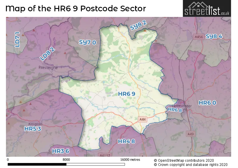
The HR6 9 Postcode shares a border with HR5 3 (KINGTON, Lyonshall, Titley), HR6 0 (LEOMINSTER, Kimbolton, Stoke Prior), HR3 6 (Eardisley, Whitney-on-Wye, Dorstone), HR4 8 (Weobley, Wellington, Moreton-on-Lugg), HR6 8 (LEOMINSTER, Barons Cross), SY8 2 (LUDLOW, Bromfield, Rock Green), SY8 4 (Orleton, Brimfield, Richards Castle), SY7 0 (Leintwardine, BUCKNELL, Clungunford) and LD8 2 (PRESTEIGNE, NEW RADNOR, NORTON).
The sector is within the post town of LEOMINSTER.
HR6 9 is a postcode sector within the HR6 postcode district which is within the HR Hereford postcode area.
The Royal Mail delivery office for the HR6 9 postal sector is the Leominster Delivery Office.
The area of the HR6 9 postcode sector is 56.98 square miles which is 147.59 square kilometres or 36,469.28 square acres.
Waterways within the HR6 9 postcode sector include the River Lugg, River Arrow.

Map of the HR6 9 Postcode Sector
Explore the HR6 9 postcode sector by using our free interactive map.
| H | R | 6 | - | 9 | X | X |
| H | R | 6 | Space | 9 | Letter | Letter |
Official List of Streets
Shobdon (10 Streets)
Pembridge (20 Streets)
Kingsland (15 Streets)
LEOMINSTER (10 Streets)
Wigmore (7 Streets)
Eardisland (4 Streets)
Ebnall (1 Streets)
Monkland (1 Streets)
Unofficial Streets or Alternative Spellings
LEOMINSTER
BRIDGE STREET NORTH ROAD ALMSHOUSES LANE BACON LANE BAKER LEA BONDS GREEN BROOK BRIDGE BROOME LANE BURTON BULLS CAMP ROAD CASTLE STREET CHOLSTREY ROAD CHURCH GREEN CHURCH PATH CROFT LANE CROOKMULLEN ROAD DOG LANE EARDISLAND MEMORIAL WALK HAVEN DRIVE HEREFORD LANE IVINGTON ROAD KINGSMEADOW LEDICOT LANE LEYSFIELD LANE LONG MEADOW LONGFORD LOWE FARM LANE LUCTON LANE LUGG GREEN LYME LANE MANLY LANE MARSTON LANE MONKLAND ROAD MORTIMER MEADOW MORTIMER TRAIL NEWTOWN LANE OAKER WOOD LEISURE LTD OLD LUDLOW ROAD OLD ROAD OLD SHOP OLD SHOP LANE ONGAR STREET ORCHARD CLOSE PIG AND WHISTLE LANE PRESTEIGNE ROAD ROUGH ACRE ACCESS SANDIFORD PLOC SCHOOL LANE SPOUT LANE ST MARYS WAY ST PETERS SQUARE TADPOLE LANE TEAPOT LANE THE GROVE THE STRAIGHT MILE THREE OWLS WOODGATE LANEHolme Marsh
MOOR COURT LANEWeather Forecast for HR6 9
Press Button to Show Forecast for Shobdon Saws
| Time Period | Icon | Description | Temperature | Rain Probability | Wind |
|---|---|---|---|---|---|
| 06:00 to 09:00 | Cloudy | 4.0°C (feels like 2.0°C) | 6.00% | WSW 4 mph | |
| 09:00 to 12:00 | Cloudy | 9.0°C (feels like 7.0°C) | 6.00% | WNW 7 mph | |
| 12:00 to 15:00 | Cloudy | 11.0°C (feels like 9.0°C) | 9.00% | NW 9 mph | |
| 15:00 to 18:00 | Cloudy | 11.0°C (feels like 9.0°C) | 13.00% | NNW 9 mph | |
| 18:00 to 21:00 | Cloudy | 9.0°C (feels like 8.0°C) | 10.00% | NNW 7 mph | |
| 21:00 to 00:00 | Cloudy | 7.0°C (feels like 6.0°C) | 13.00% | NE 4 mph |
Press Button to Show Forecast for Shobdon Saws
| Time Period | Icon | Description | Temperature | Rain Probability | Wind |
|---|---|---|---|---|---|
| 00:00 to 03:00 | Cloudy | 6.0°C (feels like 5.0°C) | 7.00% | NNE 2 mph | |
| 03:00 to 06:00 | Cloudy | 4.0°C (feels like 2.0°C) | 5.00% | NE 4 mph | |
| 06:00 to 09:00 | Cloudy | 4.0°C (feels like 3.0°C) | 7.00% | NE 4 mph | |
| 09:00 to 12:00 | Cloudy | 7.0°C (feels like 5.0°C) | 49.00% | E 7 mph | |
| 12:00 to 15:00 | Cloudy | 9.0°C (feels like 7.0°C) | 13.00% | ENE 7 mph | |
| 15:00 to 18:00 | Cloudy | 10.0°C (feels like 9.0°C) | 12.00% | ENE 4 mph | |
| 18:00 to 21:00 | Cloudy | 9.0°C (feels like 8.0°C) | 12.00% | NE 4 mph | |
| 21:00 to 00:00 | Cloudy | 6.0°C (feels like 4.0°C) | 13.00% | NE 4 mph |
Press Button to Show Forecast for Shobdon Saws
| Time Period | Icon | Description | Temperature | Rain Probability | Wind |
|---|---|---|---|---|---|
| 00:00 to 03:00 | Cloudy | 5.0°C (feels like 3.0°C) | 13.00% | NE 4 mph | |
| 03:00 to 06:00 | Cloudy | 3.0°C (feels like 1.0°C) | 12.00% | NNE 4 mph | |
| 06:00 to 09:00 | Cloudy | 3.0°C (feels like 1.0°C) | 13.00% | NNE 4 mph | |
| 09:00 to 12:00 | Overcast | 7.0°C (feels like 5.0°C) | 19.00% | NE 7 mph | |
| 12:00 to 15:00 | Overcast | 10.0°C (feels like 7.0°C) | 23.00% | ENE 9 mph | |
| 15:00 to 18:00 | Overcast | 10.0°C (feels like 8.0°C) | 21.00% | ENE 9 mph | |
| 18:00 to 21:00 | Cloudy | 10.0°C (feels like 8.0°C) | 18.00% | NE 9 mph | |
| 21:00 to 00:00 | Cloudy | 8.0°C (feels like 6.0°C) | 22.00% | NE 9 mph |
Press Button to Show Forecast for Shobdon Saws
| Time Period | Icon | Description | Temperature | Rain Probability | Wind |
|---|---|---|---|---|---|
| 00:00 to 03:00 | Light rain | 7.0°C (feels like 4.0°C) | 47.00% | NNE 7 mph | |
| 03:00 to 06:00 | Heavy rain | 6.0°C (feels like 3.0°C) | 74.00% | N 7 mph | |
| 06:00 to 09:00 | Light rain | 6.0°C (feels like 2.0°C) | 55.00% | N 7 mph | |
| 09:00 to 12:00 | Light rain | 7.0°C (feels like 4.0°C) | 56.00% | N 9 mph | |
| 12:00 to 15:00 | Light rain | 10.0°C (feels like 7.0°C) | 54.00% | N 11 mph | |
| 15:00 to 18:00 | Light rain | 11.0°C (feels like 8.0°C) | 50.00% | NNW 9 mph | |
| 18:00 to 21:00 | Light rain shower (day) | 11.0°C (feels like 9.0°C) | 34.00% | NNW 7 mph | |
| 21:00 to 00:00 | Clear night | 7.0°C (feels like 6.0°C) | 5.00% | W 4 mph |
Schools and Places of Education Within the HR6 9 Postcode Sector
Kingsland CofE School
Voluntary aided school
Kingsland, Leominster, Herefordshire, HR6 9QN
Head: Mr Stewart Debenham
Ofsted Rating: Good
Inspection: 2023-01-18 (463 days ago)
Website: Visit Kingsland CofE School Website
Phone: 01568708436
Number of Pupils: 157
Pembridge CofE Primary School
Voluntary aided school
Bearwood Lane, Leominster, Herefordshire, HR6 9EA
Head: Mr Robert Hollis
Ofsted Rating: Outstanding
Inspection: 2014-10-03 (3492 days ago)
Website: Visit Pembridge CofE Primary School Website
Phone: 01544388366
Number of Pupils: 80
Shobdon Primary School
Community school
Shobdon, Leominster, Herefordshire, HR6 9LX
Head: Mrs Mary Freeman
Ofsted Rating: Good
Inspection: 2018-12-05 (1968 days ago)
Website: Visit Shobdon Primary School Website
Phone: 01568708386
Number of Pupils: 89
Wigmore Primary School
Academy converter
Ford Street, Leominster, Herefordshire, HR6 9UN
Head: Dr Robert Patterson
Ofsted Rating: Good
Inspection: 2019-10-23 (1646 days ago)
Website: Visit Wigmore Primary School Website
Phone: 01568770333
Number of Pupils: 165
Wigmore School
Academy converter
Ford Street, Leominster, Herefordshire, HR6 9UW
Head: Dr Robert Patterson
Ofsted Rating: Good
Inspection: 2023-06-29 (301 days ago)
Website: Visit Wigmore School Website
Phone: 01568770323
Number of Pupils: 442
House Prices in the HR6 9 Postcode Sector
| Type of Property | 2018 Average | 2018 Sales | 2017 Average | 2017 Sales | 2016 Average | 2016 Sales | 2015 Average | 2015 Sales |
|---|---|---|---|---|---|---|---|---|
| Detached | £367,848 | 56 | £327,841 | 58 | £357,658 | 56 | £303,266 | 56 |
| Semi-Detached | £237,150 | 23 | £195,625 | 18 | £175,869 | 27 | £174,077 | 13 |
| Terraced | £216,434 | 16 | £196,639 | 18 | £172,568 | 14 | £181,647 | 17 |
| Flats | £0 | 0 | £0 | 0 | £0 | 0 | £0 | 0 |
Important Postcodes HR6 9 in the Postcode Sector
HR6 9BP is the postcode for Eardisland Village Hall, Church Road
HR6 9EA is the postcode for Pembridge C of E Primary School, Bearwood Lane, Pembridge, and Pembridge C of E Primary School, Bearwood Lane
HR6 9LX is the postcode for Shobdon Primary School, Shobdon
HR6 9QL is the postcode for Croase Orchard Surgery, Kingsland
HR6 9QN is the postcode for Kingsland C of E Primary School, Kingsland
HR6 9UN is the postcode for Wigmore Primary School, Ford Street
HR6 9UW is the postcode for Wigmore High School, Ford Street, and Wigmore High School, Ford Street, Wigmore
| The HR6 9 Sector is within these Local Authorities |
|
|---|---|
| The HR6 9 Sector is within these Counties |
|
| The HR6 9 Sector is within these Water Company Areas |
|