This section of the site is all about the HU Postcode area, also known as the Hull Postal Area. Explore links to the next level to learn more about specific postcode districts such as HU1.
The HU postcode area represents a group of postal districts in the Hull area of the United Kingdom. The area code HU stands for the letters h and u in HUll. HU has a population of 443,223 and covers an area of 944,830 hectares. Fun fact: 0.68% of the population of Great Britain lives in this area.
The postcode area falls within the following counties: East Riding of Yorkshire (100.00%).
Post Towns and Postcode Districts for the HU Postcode
-
HU1 East Riding of YorkshireHU2 East Riding of YorkshireHU3 East Riding of YorkshireHU4 East Riding of YorkshireHU5 East Riding of YorkshireHU6 East Riding of YorkshireHU7 East Riding of YorkshireHU8 East Riding of YorkshireHU9 East Riding of YorkshireHU10 East Riding of YorkshireHU11 East Riding of YorkshireHU12 East Riding of Yorkshire
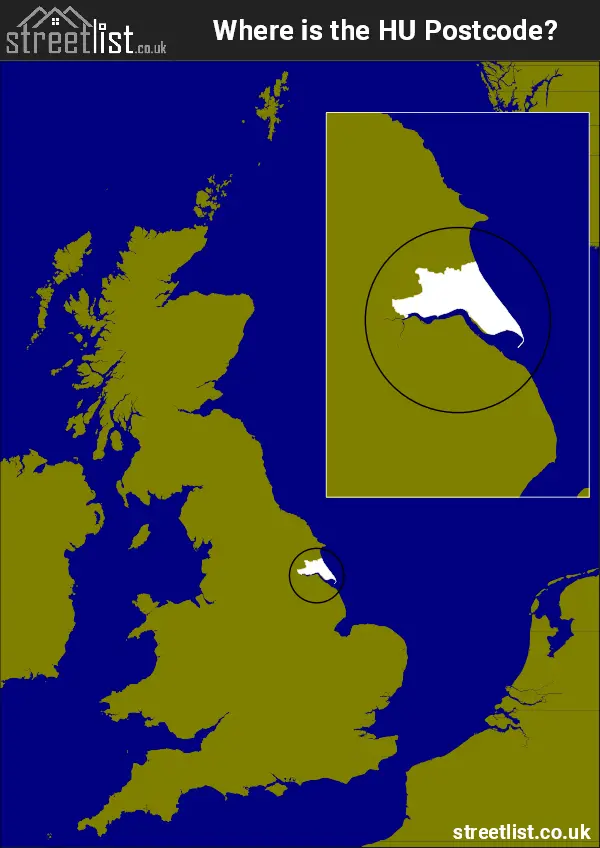
Where is the HU Postcode Area?
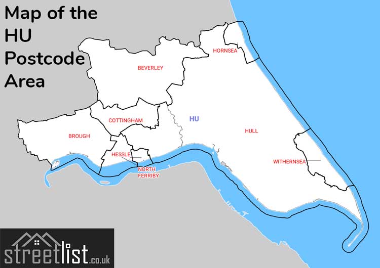
The Hull HU Postcode is in Yorkshire and the Humber Region of England. The postal area borders the following neighbouring postal areas: YO - York and DN - Doncaster, It also borders The North Sea and The Humber.
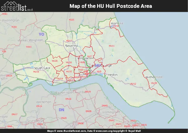
Map of the HU Hull Postcode Area
Explore the HU Hull postcode area by using our interactive map.
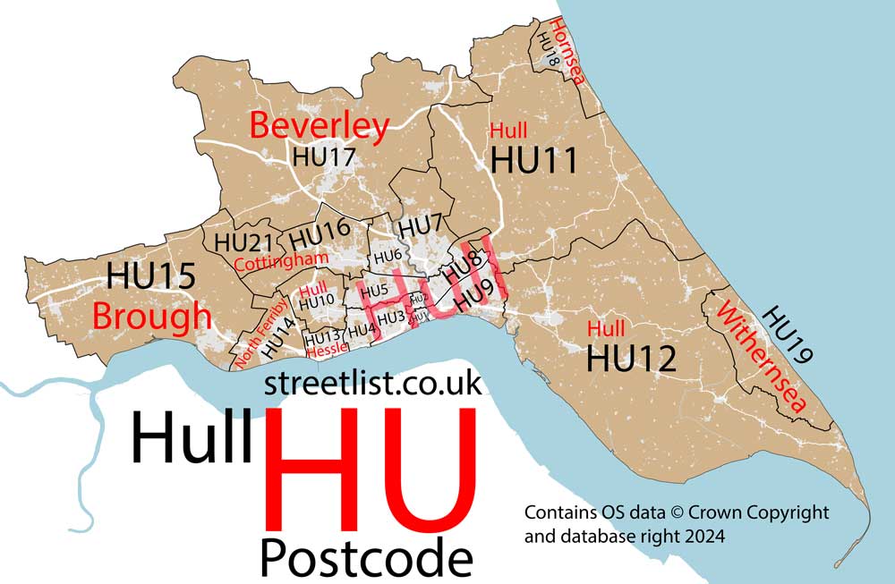
Postcode Districts within the HU Hull Postcode Area
There are 20 postcode districts within the Hull postcode area
A map showing the boundary of in relation to other areas
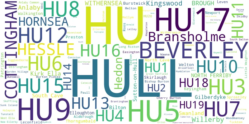
There are 7 towns within the Hull postcode area.
| Unit | Area² |
|---|---|
| Hectares | 944,830² |
| Miles | 3,648² |
| Feet | 101,700,556,370² |
| Kilometres | 9,448² |
Postal Delivery Offices serving the HU Hull Postcode Area
- Aldbrough Scale Payment Delivery Office
- Beverley Delivery Office
- Brough Scale Payment Delivery Office
- Burton Pidsea Scale Payment Delivery Office
- Cottingham Delivery Office
- Gilberdyke Scale Payment Delivery Office
- Harpings Road Delivery Office
- Hornsea Scale Payment Delivery Office
- Hull City Delivery Office
- Keyingham Scale Payment Delivery Office
- Malmo Road Delivery Office
- Newport (hu) Scale Payment Delivery Office
- North Cave Scale Payment Delivery Office
- Patrington Scale Payment Delivery Office
- Saxon Way Postal Delivery Office
- Seaton Scale Payment Delivery Office
- Skirlaugh Scale Payment Delivery Office
- South Cave Scale Payment Delivery Office
- Sproatley Scale Payment Delivery Office
- Thorngumbald Scale Payment Delivery Office
- Withernsea Scale Payment Delivery Office
Councils with Postcodes in HU
Towns and Villages within the HU Hull Postcode Area
- Aldbrough - village
- Anlaby - village
- Arnold - village
- Beverley - town
- Bilton - village
- Bishop Burton - village
- Brantingham - village
- Broomfleet - village
- Brough - village
- Burstwick - village
- Burton Pidsea - village
- Camerton - village
- Catwick - village
- Cherry Burton - village
- Coniston - village
- Cottingham - town
- Dunswell - village
- Easington - village
- Ellerker - village
- Elloughton - village
- Elstronwick - village
- Etton - village
- Gilberdyke - village
- Great Cowden - village
- Great Hatfield - village
- Halsham - village
- Hedon - town
- Hessle - town
- Hollym - village
- Holmpton - village
- Hornsea - town
- Humbleton - village
- Keyingham - village
- Kilnsea - otherSettlement
- Kingston upon Hull - city
- Kirk Ella - village
- Leconfield - village
- Leven - village
- Little Weighton - village
- Long Riston - village
- Mappleton - village
- Melton - village
- New Ellerby - village
- Newport - village
- North Cave - village
- North Ferriby - village
- Old Ellerby - village
- Ottringham - village
- Patrington - village
- Patrington Haven - village
- Paull - village
- Preston - village
- Rimswell - otherSettlement
- Riplingham - otherSettlement
- Roos - village
- Routh - village
- Ryehill - village
- Sandholme - otherSettlement
- Seaton - village
- Sigglesthorne - village
- Skeffling - village
- Skidby - village
- Skirlaugh - village
- South Cave - town
- South Dalton - village
- Sproatley - village
- Swanland - village
- Thorngumbald - village
- Tickton - village
- Tunstall - village
- Walkington - village
- Wawne - village
- Weel - village
- Welton - village
- Welwick - village
- West Ella - village
- Whitedale - otherSettlement
- Willerby - village
- Withernsea - town
- Withernwick - village
- Woodmansey - village