The HU13 9 postcode sector is within the county of East Riding of Yorkshire.
Did you know? According to the 2021 Census, the HU13 9 postcode sector is home to a bustling 7,300 residents!
Given that each sector allows for 400 unique postcode combinations. Letters C, I, K, M, O and V are not allowed in the last two letters of a postcode. With 159 postcodes already in use, this leaves 241 units available.
The HU13 9 postal code covers the settlement of HESSLE.
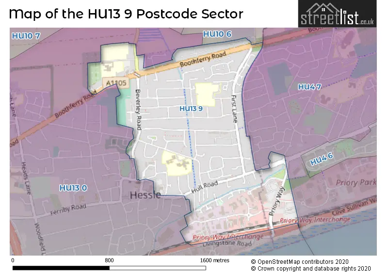
The HU13 9 Postcode shares a border with HU4 7 (HULL, Anlaby Common), HU10 6 (Willerby, Anlaby) and HU13 0 (HESSLE).
The sector is within the post town of HESSLE.
HU13 9 is a postcode sector within the HU13 postcode district which is within the HU Hull postcode area.
The Royal Mail delivery office for the HU13 9 postal sector is the Saxon Way Postal Delivery Office.
The area of the HU13 9 postcode sector is 0.66 square miles which is 1.70 square kilometres or 419.90 square acres.
The HU13 9 postcode sector is crossed by the A63 Major A road.

Map of the HU13 9 Postcode Sector
Explore the HU13 9 postcode sector by using our free interactive map.
| H | U | 1 | 3 | - | 9 | X | X |
| H | U | 1 | 3 | Space | 9 | Letter | Letter |
Official List of Streets
HESSLE (80 Streets)
Unofficial Streets or Alternative Spellings
HESSLE,
BETHUNE AVENUE BOOTHFERRY ROAD HESSLE ROADAnlaby
BEVERLEY ROAD FIRST LANEHULL
ANLABY PARK ROAD SOUTH HENRY BOOT WAY MOLLISON ROADHESSLE
ROBERT BARNETT CLOSE SWANLAND ROAD THE WILLOWS TRINITY GROVE ALBANY VILLAS BETHUNE AVENUE WEST CANON TARDREW CLOSE CLIVE SULLIVAN WAY FENBY COURT MOLLISON ROAD WEST NORTHGATE PLACE PEARTS ARCH PRIMROSE VILLAS PRIORY WAY SAXON WAY SEEL COURTWeather Forecast for HU13 9
Press Button to Show Forecast for Hessle
| Time Period | Icon | Description | Temperature | Rain Probability | Wind |
|---|---|---|---|---|---|
| 06:00 to 09:00 | Cloudy | 5.0°C (feels like 2.0°C) | 10.00% | W 9 mph | |
| 09:00 to 12:00 | Cloudy | 6.0°C (feels like 4.0°C) | 37.00% | NNW 9 mph | |
| 12:00 to 15:00 | Light rain shower (day) | 8.0°C (feels like 6.0°C) | 41.00% | N 7 mph | |
| 15:00 to 18:00 | Cloudy | 9.0°C (feels like 7.0°C) | 14.00% | NNE 7 mph | |
| 18:00 to 21:00 | Sunny day | 7.0°C (feels like 4.0°C) | 1.00% | NNE 9 mph | |
| 21:00 to 00:00 | Clear night | 4.0°C (feels like 2.0°C) | 0.00% | N 4 mph |
Press Button to Show Forecast for Hessle
| Time Period | Icon | Description | Temperature | Rain Probability | Wind |
|---|---|---|---|---|---|
| 00:00 to 03:00 | Partly cloudy (night) | 3.0°C (feels like 0.0°C) | 1.00% | NNW 4 mph | |
| 03:00 to 06:00 | Partly cloudy (night) | 2.0°C (feels like 0.0°C) | 1.00% | NW 4 mph | |
| 06:00 to 09:00 | Partly cloudy (day) | 3.0°C (feels like 1.0°C) | 2.00% | NNW 4 mph | |
| 09:00 to 12:00 | Cloudy | 7.0°C (feels like 6.0°C) | 5.00% | NE 7 mph | |
| 12:00 to 15:00 | Cloudy | 8.0°C (feels like 7.0°C) | 11.00% | ENE 7 mph | |
| 15:00 to 18:00 | Overcast | 9.0°C (feels like 7.0°C) | 13.00% | E 7 mph | |
| 18:00 to 21:00 | Cloudy | 8.0°C (feels like 5.0°C) | 8.00% | E 7 mph | |
| 21:00 to 00:00 | Partly cloudy (night) | 4.0°C (feels like 2.0°C) | 2.00% | E 4 mph |
Press Button to Show Forecast for Hessle
| Time Period | Icon | Description | Temperature | Rain Probability | Wind |
|---|---|---|---|---|---|
| 00:00 to 03:00 | Partly cloudy (night) | 3.0°C (feels like 1.0°C) | 3.00% | NE 4 mph | |
| 03:00 to 06:00 | Cloudy | 3.0°C (feels like 1.0°C) | 9.00% | NE 4 mph | |
| 06:00 to 09:00 | Partly cloudy (day) | 5.0°C (feels like 2.0°C) | 7.00% | ENE 7 mph | |
| 09:00 to 12:00 | Cloudy | 9.0°C (feels like 6.0°C) | 10.00% | ENE 9 mph | |
| 12:00 to 15:00 | Cloudy | 10.0°C (feels like 7.0°C) | 14.00% | E 11 mph | |
| 15:00 to 18:00 | Cloudy | 10.0°C (feels like 8.0°C) | 15.00% | ENE 11 mph | |
| 18:00 to 21:00 | Cloudy | 9.0°C (feels like 6.0°C) | 12.00% | ENE 11 mph | |
| 21:00 to 00:00 | Cloudy | 7.0°C (feels like 4.0°C) | 11.00% | NE 9 mph |
Press Button to Show Forecast for Hessle
| Time Period | Icon | Description | Temperature | Rain Probability | Wind |
|---|---|---|---|---|---|
| 00:00 to 03:00 | Cloudy | 7.0°C (feels like 4.0°C) | 18.00% | NE 11 mph | |
| 03:00 to 06:00 | Light rain | 7.0°C (feels like 4.0°C) | 52.00% | NE 13 mph | |
| 06:00 to 09:00 | Heavy rain | 8.0°C (feels like 5.0°C) | 78.00% | NE 13 mph | |
| 09:00 to 12:00 | Heavy rain | 9.0°C (feels like 6.0°C) | 79.00% | ENE 16 mph | |
| 12:00 to 15:00 | Light rain | 10.0°C (feels like 8.0°C) | 51.00% | ENE 13 mph | |
| 15:00 to 18:00 | Light rain shower (day) | 10.0°C (feels like 7.0°C) | 43.00% | E 13 mph | |
| 18:00 to 21:00 | Light rain | 9.0°C (feels like 7.0°C) | 49.00% | NNE 11 mph | |
| 21:00 to 00:00 | Partly cloudy (night) | 8.0°C (feels like 5.0°C) | 7.00% | S 9 mph |
Schools and Places of Education Within the HU13 9 Postcode Sector
All Saints Church of England Junior Academy
Academy converter
Northolme Road, Hessle, , HU13 9JD
Head: Miss Laura Jackson
Ofsted Rating: Good
Inspection: 2023-11-22 (155 days ago)
Website: Visit All Saints Church of England Junior Academy Website
Phone: 01482648082
Number of Pupils: 386
St Anne's School and Sixth Form College
Community special school
Boothferry Road, Hessle, , HU13 9AR
Head: Miss Hendi Longman
Ofsted Rating: Good
Inspection: 2023-06-28 (302 days ago)
Website: Visit St Anne's School and Sixth Form College Website
Phone: 01482667379
Number of Pupils: 168
House Prices in the HU13 9 Postcode Sector
| Type of Property | 2018 Average | 2018 Sales | 2017 Average | 2017 Sales | 2016 Average | 2016 Sales | 2015 Average | 2015 Sales |
|---|---|---|---|---|---|---|---|---|
| Detached | £250,455 | 11 | £176,300 | 5 | £219,444 | 9 | £206,933 | 9 |
| Semi-Detached | £145,117 | 40 | £143,557 | 35 | £138,491 | 49 | £135,349 | 42 |
| Terraced | £121,049 | 101 | £131,576 | 84 | £115,311 | 87 | £118,320 | 77 |
| Flats | £90,000 | 5 | £66,987 | 4 | £65,700 | 5 | £78,119 | 8 |
Important Postcodes HU13 9 in the Postcode Sector
HU13 9AR is the postcode for HESSLE HIGH (LOWER SCHOOL), Hessle High School, Boothferry Road
HU13 9EX is the postcode for Hessle Penshurst Primary School, Winthorpe Road
HU13 9JD is the postcode for BLOCK C, All Saints CE Junior School, Northolme Road, All Saints CE Junior School, Northolme Road, All Saints C of E Infant School, Northolme Road, and BLOCK B, All Saints CE Junior School, Northolme Road
HU13 9LZ is the postcode for Hessle Health Centre, 11 Hull Road
HU13 9NA is the postcode for East Riding of Yorkshire Council, Hessle District Office, 3 Eastgate
HU13 9NW is the postcode for RECREATION, 2062-2068, Hessle Road, Humber Mental Health Teaching NHS Trust, West End Adolescent Unit, and RESIDENTIAL BLOCK, West End Adolescent Service, 2062-2068 Hessle Road
HU13 9TA is the postcode for Royal Mail, Saxon Way Delivery Office, Priory Park, Saxon Way
| The HU13 9 Sector is within these Local Authorities |
|
|---|---|
| The HU13 9 Sector is within these Counties |
|
| The HU13 9 Sector is within these Water Company Areas |
|