The HU14 3 postcode sector is within the county of East Riding of Yorkshire.
Did you know? According to the 2021 Census, the HU14 3 postcode sector is home to a bustling 8,549 residents!
Given that each sector allows for 400 unique postcode combinations. Letters C, I, K, M, O and V are not allowed in the last two letters of a postcode. With 214 postcodes already in use, this leaves 186 units available.
The largest settlement in the HU14 3 postal code is Swanland followed by NORTH FERRIBY, and Melton.
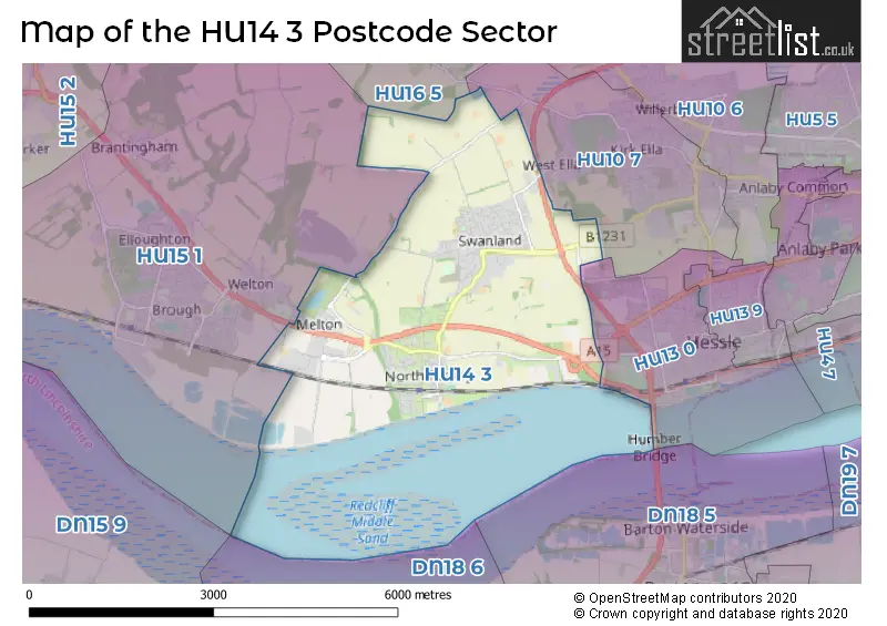
The HU14 3 Postcode shares a border with HU13 0 (HESSLE), HU15 1 (BROUGH, Elloughton, Welton), HU10 7 (Kirk Ella, Anlaby, West Ella) and HU16 5 (COTTINGHAM, Skidby, Raywell).
The sector is within the post town of NORTH FERRIBY.
HU14 3 is a postcode sector within the HU14 postcode district which is within the HU Hull postcode area.
The Royal Mail delivery office for the HU14 3 postal sector is the Saxon Way Postal Delivery Office.
The area of the HU14 3 postcode sector is 7.33 square miles which is 19.00 square kilometres or 4,693.81 square acres.
The HU14 3 postcode sector is crossed by the A63 Major A road.

Map of the HU14 3 Postcode Sector
Explore the HU14 3 postcode sector by using our free interactive map.
| H | U | 1 | 4 | - | 3 | X | X |
| H | U | 1 | 4 | Space | 3 | Letter | Letter |
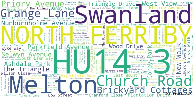
Official List of Streets
Swanland (74 Streets)
NORTH FERRIBY (67 Streets)
Melton (18 Streets)
Unofficial Streets or Alternative Spellings
HESSLE
JENNY BROUGH LANE BAKERS YARD BLACKSMITHS YARD BLASKET LANE BLASKETS LANE BOW WALK CHALK LANE CLIVE SULLIVAN WAY CROWTHER COURT DALE COURT GREENACRES LOW FIELD LANE LOW ROAD MELTON INTERCHANGE MONKS WAY (WEST) MONKS WAY EAST RAYWELL LANE SANDS COURT SOUTHFIELDDRIVE SPINNEYCROFT CLOSE STAPLETON COURT SWANLAND COURT SWANLAND DALE TOM POTTS ROW WOODSIDESwanland
DALE FLATS MERE FLATSNORTH FERRIBY
BRICKYARD COTTAGES STATION VIEW WHITE HOUSE MEWSWelton
COMMON LANE POOLBANK LANEKirk Ella
WEST ELLA ROADAnlaby
TRANBY LANEBROUGH,
PETUARIA WAYWeather Forecast for HU14 3
Press Button to Show Forecast for South Field
| Time Period | Icon | Description | Temperature | Rain Probability | Wind |
|---|---|---|---|---|---|
| 03:00 to 06:00 | Cloudy | 4.0°C (feels like 1.0°C) | 8.00% | NW 9 mph | |
| 06:00 to 09:00 | Partly cloudy (day) | 4.0°C (feels like 1.0°C) | 2.00% | NNW 9 mph | |
| 09:00 to 12:00 | Overcast | 7.0°C (feels like 3.0°C) | 9.00% | N 13 mph | |
| 12:00 to 15:00 | Overcast | 8.0°C (feels like 5.0°C) | 8.00% | N 13 mph | |
| 15:00 to 18:00 | Cloudy | 9.0°C (feels like 6.0°C) | 4.00% | N 11 mph | |
| 18:00 to 21:00 | Cloudy | 7.0°C (feels like 5.0°C) | 3.00% | NNE 9 mph | |
| 21:00 to 00:00 | Partly cloudy (night) | 5.0°C (feels like 3.0°C) | 1.00% | SSW 4 mph |
Press Button to Show Forecast for South Field
| Time Period | Icon | Description | Temperature | Rain Probability | Wind |
|---|---|---|---|---|---|
| 00:00 to 03:00 | Cloudy | 5.0°C (feels like 2.0°C) | 4.00% | WSW 9 mph | |
| 03:00 to 06:00 | Cloudy | 5.0°C (feels like 1.0°C) | 5.00% | WSW 11 mph | |
| 06:00 to 09:00 | Partly cloudy (day) | 5.0°C (feels like 1.0°C) | 4.00% | WNW 11 mph | |
| 09:00 to 12:00 | Cloudy | 7.0°C (feels like 4.0°C) | 9.00% | NW 11 mph | |
| 12:00 to 15:00 | Light rain shower (day) | 8.0°C (feels like 5.0°C) | 32.00% | NNW 9 mph | |
| 15:00 to 18:00 | Light rain shower (day) | 9.0°C (feels like 6.0°C) | 30.00% | N 9 mph | |
| 18:00 to 21:00 | Partly cloudy (day) | 7.0°C (feels like 5.0°C) | 4.00% | NNE 9 mph | |
| 21:00 to 00:00 | Clear night | 4.0°C (feels like 2.0°C) | 3.00% | N 4 mph |
Press Button to Show Forecast for South Field
| Time Period | Icon | Description | Temperature | Rain Probability | Wind |
|---|---|---|---|---|---|
| 00:00 to 03:00 | Partly cloudy (night) | 2.0°C (feels like 0.0°C) | 2.00% | N 4 mph | |
| 03:00 to 06:00 | Partly cloudy (night) | 2.0°C (feels like 0.0°C) | 3.00% | NW 4 mph | |
| 06:00 to 09:00 | Cloudy | 3.0°C (feels like 2.0°C) | 5.00% | N 4 mph | |
| 09:00 to 12:00 | Cloudy | 7.0°C (feels like 6.0°C) | 8.00% | NE 7 mph | |
| 12:00 to 15:00 | Overcast | 9.0°C (feels like 8.0°C) | 13.00% | E 7 mph | |
| 15:00 to 18:00 | Overcast | 9.0°C (feels like 7.0°C) | 13.00% | E 9 mph | |
| 18:00 to 21:00 | Cloudy | 8.0°C (feels like 6.0°C) | 11.00% | ESE 9 mph | |
| 21:00 to 00:00 | Cloudy | 6.0°C (feels like 4.0°C) | 10.00% | E 7 mph |
Press Button to Show Forecast for South Field
| Time Period | Icon | Description | Temperature | Rain Probability | Wind |
|---|---|---|---|---|---|
| 00:00 to 03:00 | Cloudy | 5.0°C (feels like 3.0°C) | 15.00% | ESE 7 mph | |
| 03:00 to 06:00 | Cloudy | 5.0°C (feels like 3.0°C) | 18.00% | E 7 mph | |
| 06:00 to 09:00 | Overcast | 6.0°C (feels like 4.0°C) | 21.00% | E 9 mph | |
| 09:00 to 12:00 | Cloudy | 9.0°C (feels like 6.0°C) | 21.00% | E 11 mph | |
| 12:00 to 15:00 | Cloudy | 10.0°C (feels like 8.0°C) | 20.00% | E 11 mph | |
| 15:00 to 18:00 | Light rain | 11.0°C (feels like 8.0°C) | 48.00% | ENE 11 mph | |
| 18:00 to 21:00 | Cloudy | 10.0°C (feels like 7.0°C) | 15.00% | E 11 mph | |
| 21:00 to 00:00 | Cloudy | 8.0°C (feels like 6.0°C) | 14.00% | ENE 9 mph |
Schools and Places of Education Within the HU14 3 Postcode Sector
North Ferriby Church of England Voluntary Controlled Primary School
Voluntary controlled school
Church Road, North Ferriby, , HU14 3BZ
Head: Mrs Joanne Spencer
Ofsted Rating: Good
Inspection: 2023-07-12 (287 days ago)
Website: Visit North Ferriby Church of England Voluntary Controlled Primary School Website
Phone: 01482631200
Number of Pupils: 291
South Hunsley School and Sixth Form College
Academy converter
East Dale Road, North Ferriby, , HU14 3HS
Head: Ms Michaela Blackledge
Ofsted Rating: Outstanding
Inspection: 2013-05-15 (3997 days ago)
Website: Visit South Hunsley School and Sixth Form College Website
Phone: 01482631208
Number of Pupils: 2115
Swanland Primary School
Academy converter
Tranby Lane, North Ferriby, , HU14 3NE
Head: Miss Hannah Stephenson
Ofsted Rating: Outstanding
Inspection: 2013-05-22 (3990 days ago)
Website: Visit Swanland Primary School Website
Phone: 01482631300
Number of Pupils: 429
House Prices in the HU14 3 Postcode Sector
| Type of Property | 2018 Average | 2018 Sales | 2017 Average | 2017 Sales | 2016 Average | 2016 Sales | 2015 Average | 2015 Sales |
|---|---|---|---|---|---|---|---|---|
| Detached | £436,930 | 69 | £431,791 | 101 | £411,822 | 94 | £390,932 | 85 |
| Semi-Detached | £208,115 | 47 | £203,245 | 52 | £225,980 | 48 | £195,342 | 49 |
| Terraced | £164,017 | 15 | £172,150 | 13 | £162,727 | 13 | £172,242 | 24 |
| Flats | £166,218 | 8 | £147,878 | 9 | £110,400 | 5 | £79,300 | 5 |
Important Postcodes HU14 3 in the Postcode Sector
HU14 3BZ is the postcode for JUNIOR SCHOOL, North Ferriby C of E School, Church Road, BLOCK A, North Ferriby C of E School, Church Road, North Ferriby C of E School, Church Road, and INFANT SCHOOL, North Ferriby C of E School, Church Road
HU14 3HH is the postcode for East Riding of Yorkshire Council, Gibson Lane, and East Riding Of Yorkshire Council Supplies, Gibson Lane South
HU14 3HS is the postcode for PRIMARY SCHOOL, South Hunsley School, East Dale Road, EASTDALE, South Hunsley School, East Dale Road, SPORTS HALL, South Hunsley School, East Dale Road, KINGSTON BUILDING, South Hunsley School, East Dale Road, TECHNOLOGY BLOCK, South Hunsley School, East Dale Road, RIDING BUILDING, South Hunsley School, East Dale Road, HUMBER BUILDING, South Hunsley School, East Dale Road, and WELTON, South Hunsley School, East Dale Road
HU14 3NE is the postcode for Swanland Primary School, Tranby Lane, and Swanland Primary School, Tranby Lane, Swanland
| The HU14 3 Sector is within these Local Authorities |
|
|---|---|
| The HU14 3 Sector is within these Counties |
|
| The HU14 3 Sector is within these Water Company Areas |
|