The HU6 8 postcode sector is within the county of East Riding of Yorkshire.
Did you know? According to the 2021 Census, the HU6 8 postcode sector is home to a bustling 10,162 residents!
Given that each sector allows for 400 unique postcode combinations. Letters C, I, K, M, O and V are not allowed in the last two letters of a postcode. With 209 postcodes already in use, this leaves 191 units available.
The HU6 8 postal code covers the settlement of HULL.
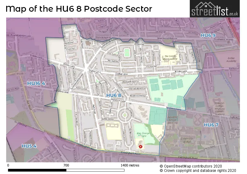
The HU6 8 Postcode shares a border with HU6 7 (HULL), HU6 9 (HULL), HU16 4 (COTTINGHAM) and HU5 4 (HULL).
The sector is within the post town of HULL.
HU6 8 is a postcode sector within the HU6 postcode district which is within the HU Hull postcode area.
The Royal Mail delivery office for the HU6 8 postal sector is the Malmo Road Delivery Office.
The area of the HU6 8 postcode sector is 0.79 square miles which is 2.05 square kilometres or 505.82 square acres.

Map of the HU6 8 Postcode Sector
Explore the HU6 8 postcode sector by using our free interactive map.
| H | U | 6 | - | 8 | X | X |
| H | U | 6 | Space | 8 | Letter | Letter |
Official List of Streets
HULL (85 Streets)
Unofficial Streets or Alternative Spellings
Weather Forecast for HU6 8
Press Button to Show Forecast for Newland
| Time Period | Icon | Description | Temperature | Rain Probability | Wind |
|---|---|---|---|---|---|
| 21:00 to 00:00 | Cloudy | 5.0°C (feels like 4.0°C) | 5.00% | NNW 2 mph |
Press Button to Show Forecast for Newland
| Time Period | Icon | Description | Temperature | Rain Probability | Wind |
|---|---|---|---|---|---|
| 00:00 to 03:00 | Cloudy | 5.0°C (feels like 2.0°C) | 5.00% | SW 7 mph | |
| 03:00 to 06:00 | Cloudy | 5.0°C (feels like 2.0°C) | 5.00% | WSW 9 mph | |
| 06:00 to 09:00 | Cloudy | 5.0°C (feels like 2.0°C) | 48.00% | W 9 mph | |
| 09:00 to 12:00 | Light rain | 6.0°C (feels like 4.0°C) | 44.00% | NNW 9 mph | |
| 12:00 to 15:00 | Light rain shower (day) | 8.0°C (feels like 6.0°C) | 58.00% | N 9 mph | |
| 15:00 to 18:00 | Cloudy | 9.0°C (feels like 6.0°C) | 10.00% | NNE 9 mph | |
| 18:00 to 21:00 | Sunny day | 7.0°C (feels like 4.0°C) | 1.00% | NNE 9 mph | |
| 21:00 to 00:00 | Clear night | 4.0°C (feels like 2.0°C) | 0.00% | N 4 mph |
Press Button to Show Forecast for Newland
| Time Period | Icon | Description | Temperature | Rain Probability | Wind |
|---|---|---|---|---|---|
| 00:00 to 03:00 | Partly cloudy (night) | 3.0°C (feels like 0.0°C) | 0.00% | NNW 4 mph | |
| 03:00 to 06:00 | Partly cloudy (night) | 2.0°C (feels like 0.0°C) | 1.00% | NW 4 mph | |
| 06:00 to 09:00 | Cloudy | 4.0°C (feels like 2.0°C) | 5.00% | NNW 4 mph | |
| 09:00 to 12:00 | Cloudy | 7.0°C (feels like 5.0°C) | 6.00% | NE 7 mph | |
| 12:00 to 15:00 | Cloudy | 9.0°C (feels like 7.0°C) | 40.00% | ENE 7 mph | |
| 15:00 to 18:00 | Cloudy | 9.0°C (feels like 7.0°C) | 12.00% | E 7 mph | |
| 18:00 to 21:00 | Cloudy | 8.0°C (feels like 6.0°C) | 6.00% | E 7 mph | |
| 21:00 to 00:00 | Clear night | 4.0°C (feels like 2.0°C) | 2.00% | E 7 mph |
Press Button to Show Forecast for Newland
| Time Period | Icon | Description | Temperature | Rain Probability | Wind |
|---|---|---|---|---|---|
| 00:00 to 03:00 | Partly cloudy (night) | 4.0°C (feels like 2.0°C) | 3.00% | ENE 4 mph | |
| 03:00 to 06:00 | Cloudy | 3.0°C (feels like 1.0°C) | 9.00% | NE 4 mph | |
| 06:00 to 09:00 | Partly cloudy (day) | 5.0°C (feels like 3.0°C) | 7.00% | ENE 4 mph | |
| 09:00 to 12:00 | Cloudy | 9.0°C (feels like 6.0°C) | 10.00% | E 9 mph | |
| 12:00 to 15:00 | Cloudy | 10.0°C (feels like 7.0°C) | 14.00% | E 11 mph | |
| 15:00 to 18:00 | Cloudy | 10.0°C (feels like 8.0°C) | 15.00% | ENE 11 mph | |
| 18:00 to 21:00 | Cloudy | 9.0°C (feels like 6.0°C) | 13.00% | ENE 11 mph | |
| 21:00 to 00:00 | Cloudy | 8.0°C (feels like 5.0°C) | 11.00% | NE 9 mph |
Press Button to Show Forecast for Newland
| Time Period | Icon | Description | Temperature | Rain Probability | Wind |
|---|---|---|---|---|---|
| 00:00 to 03:00 | Overcast | 8.0°C (feels like 5.0°C) | 21.00% | NE 11 mph | |
| 03:00 to 06:00 | Light rain | 8.0°C (feels like 4.0°C) | 52.00% | NE 13 mph | |
| 06:00 to 09:00 | Heavy rain | 8.0°C (feels like 5.0°C) | 78.00% | NE 13 mph | |
| 09:00 to 12:00 | Heavy rain | 10.0°C (feels like 7.0°C) | 79.00% | ENE 16 mph | |
| 12:00 to 15:00 | Light rain shower (day) | 11.0°C (feels like 8.0°C) | 41.00% | ENE 13 mph | |
| 15:00 to 18:00 | Light rain shower (day) | 10.0°C (feels like 7.0°C) | 55.00% | NE 13 mph | |
| 18:00 to 21:00 | Light rain | 9.0°C (feels like 7.0°C) | 51.00% | NNE 11 mph | |
| 21:00 to 00:00 | Partly cloudy (night) | 8.0°C (feels like 6.0°C) | 7.00% | S 9 mph |
Schools and Places of Education Within the HU6 8 Postcode Sector
Frederick Holmes School
Academy special converter
Inglemire Lane, Hull, , HU6 8JJ
Head: Mrs Helen Maddison
Ofsted Rating: Good
Inspection: 2023-02-22 (427 days ago)
Website: Visit Frederick Holmes School Website
Phone: 01482804766
Number of Pupils: 108
Hall Road Academy
Academy sponsor led
Hall Road, Hull, , HU6 8PP
Head: Mr Luke Pinder
Ofsted Rating: Good
Inspection: 2018-10-03 (2030 days ago)
Website: Visit Hall Road Academy Website
Phone: 01482441151
Number of Pupils: 386
McMillan Nursery School
Local authority nursery school
Eleventh Avenue, Kingston-upon-Hull, , HU6 8HT
Head: Mr Simon Bush
Ofsted Rating: Good
Inspection: 2023-10-24 (183 days ago)
Website: Visit McMillan Nursery School Website
Phone: 01482331370
Number of Pupils: 117
The Green Way Academy
Academy sponsor led
21st Avenue, Hull, , HU6 8HD
Head: Mr Simon Bush
Ofsted Rating: Good
Inspection: 2021-07-09 (1020 days ago)
Website: Visit The Green Way Academy Website
Phone: 01482331378
Number of Pupils: 416
House Prices in the HU6 8 Postcode Sector
| Type of Property | 2018 Average | 2018 Sales | 2017 Average | 2017 Sales | 2016 Average | 2016 Sales | 2015 Average | 2015 Sales |
|---|---|---|---|---|---|---|---|---|
| Detached | £147,500 | 2 | £227,650 | 5 | £140,500 | 1 | £146,375 | 4 |
| Semi-Detached | £110,415 | 41 | £108,872 | 32 | £110,373 | 45 | £105,276 | 39 |
| Terraced | £93,589 | 58 | £92,822 | 41 | £98,305 | 31 | £75,030 | 46 |
| Flats | £69,375 | 4 | £95,000 | 1 | £55,333 | 3 | £0 | 0 |
Important Postcodes HU6 8 in the Postcode Sector
HU6 8AT is the postcode for Holy Name Care Home, 240 Hall Road
HU6 8AW is the postcode for Humberside Police, 10 Courtland Road
HU6 8HD is the postcode for Green Way Primary School, 21st Avenue, Canteen Block, The Green Way Academy, Green Way Primary School, and Main Building, The Green Way Academy, Green Way Primary School
HU6 8HS is the postcode for Sure Start, 21st Avenue, and McMillan Children Centre, 21st Avenue
HU6 8HT is the postcode for McMillan Nursery School, 11th Avenue
HU6 8JH is the postcode for Oakfield School, Inglemire Lane
HU6 8JJ is the postcode for Frederick Holmes School, Inglemire Lane, and FREDERICK HOLMES SCHOOL, INGLEMIRE LANE, KINGSTON UPON HULL
HU6 8PP is the postcode for Hall Road Primary School, Hall Road, and Hall Road Academy, Hall Road Primary School, Hall Road
HU6 8QF is the postcode for New Hall Surgery, Oakfield Court
HU6 8QG is the postcode for Townend Court LD Unit, 298 Cottingham Road, Humber NHS Foundation Trust, Townend Court, 298 Cottingham Road, and Townend Court, 298 Cottingham Road
| The HU6 8 Sector is within these Local Authorities |
|
|---|---|
| The HU6 8 Sector is within these Counties |
|
| The HU6 8 Sector is within these Water Company Areas |
|