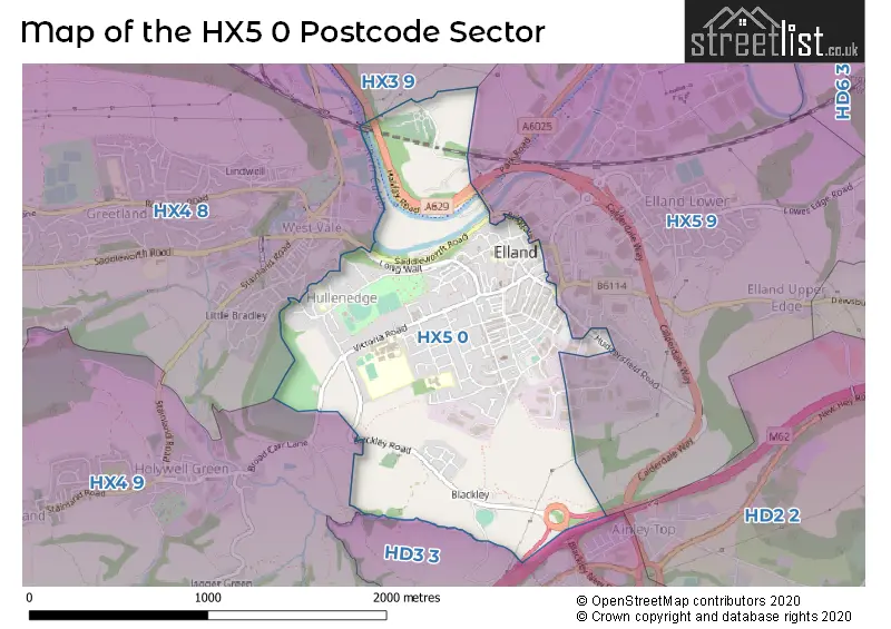
The HX5 0 postcode sector is within the county of West Yorkshire.
Did you know? According to the 2021 Census, the HX5 0 postcode sector is home to a bustling 6,476 residents!
Given that each sector allows for 400 unique postcode combinations. Letters C, I, K, M, O and V are not allowed in the last two letters of a postcode. With 179 postcodes already in use, this leaves 221 units available.
The HX5 0 postal code covers the settlement of ELLAND.
The HX5 0 Postcode shares a border with HD3 3 (HUDDERSFIELD, Lindley, Outlane), HX3 9 (HALIFAX, Southowram, Siddal), HX4 8 (Greetland), HX4 9 (Holywell Green, Stainland, Sowood) and HX5 9 (ELLAND, Lowfields Business Park).
The sector is within the post town of ELLAND.
HX5 0 is a postcode sector within the HX5 postcode district which is within the HX Halifax postcode area.
The Royal Mail delivery office for the HX5 0 postal sector is the Halifax Delivery Office.
The area of the HX5 0 postcode sector is 1.07 square miles which is 2.76 square kilometres or 681.96 square acres.
The HX5 0 postcode sector is crossed by the M62 motorway.
Waterways within the HX5 0 postcode sector include the River Calder, Calder & Hebble Navigation, Black Brook.

Map of the HX5 0 Postcode Sector
Explore the HX5 0 postcode sector by using our free interactive map.
| H | X | 5 | - | 0 | X | X |
| H | X | 5 | Space | 0 | Letter | Letter |
Official List of Streets
ELLAND (101 Streets)
Blackley (1 Streets)
Unofficial Streets or Alternative Spellings
ELLAND
BRIGGATE PARK ROAD ROSEMOUNT AVENUE THOMAS STREET ALMA STREET BACK CROSS LANE BACK SOUTH PARADE BACK WAVERLEY ROAD BLACKLEY NEW ROAD BOXWOOD ROAD CALDERDALE WAY CANAL MILLS ELIZABETH FRANCES STREET ELLAND BRIDGE ELLAND HALL ELLAND WOOD BOTTOM FEATHER BED LANE GOG HILL HAMERTON CLOSE HAMMERSTONE LEACH LANE HIGHFIELD GROVE HOLLINS HEY ROAD HOLLY BANK ROAD HULLENEDGE GARDENS HULLENEDGE LANE HULLENEDGE ROAD JOHN WILLIAM STREET LONG WALL MUCKY LANE NORTHFIELD CLOSE OLD MILL MEWS PROVIDENCE STREET ST MARYS GATE TOWN FIELDS ROAD TOWN HALL STREET TOWPATHELLAND,
EXLEY LANEBarkisland
SADDLEWORTH ROADWeather Forecast for HX5 0
Press Button to Show Forecast for Elland
| Time Period | Icon | Description | Temperature | Rain Probability | Wind |
|---|---|---|---|---|---|
| 15:00 to 18:00 | Cloudy | 10.0°C (feels like 7.0°C) | 5.00% | NNE 11 mph | |
| 18:00 to 21:00 | Cloudy | 9.0°C (feels like 7.0°C) | 3.00% | NNE 7 mph | |
| 21:00 to 00:00 | Overcast | 7.0°C (feels like 5.0°C) | 7.00% | NNE 7 mph |
Press Button to Show Forecast for Elland
| Time Period | Icon | Description | Temperature | Rain Probability | Wind |
|---|---|---|---|---|---|
| 00:00 to 03:00 | Cloudy | 5.0°C (feels like 3.0°C) | 3.00% | NNW 4 mph | |
| 03:00 to 06:00 | Partly cloudy (night) | 4.0°C (feels like 2.0°C) | 1.00% | NNW 7 mph | |
| 06:00 to 09:00 | Cloudy | 4.0°C (feels like 1.0°C) | 3.00% | NNW 7 mph | |
| 09:00 to 12:00 | Cloudy | 6.0°C (feels like 3.0°C) | 4.00% | N 9 mph | |
| 12:00 to 15:00 | Cloudy | 8.0°C (feels like 6.0°C) | 5.00% | N 9 mph | |
| 15:00 to 18:00 | Cloudy | 10.0°C (feels like 8.0°C) | 4.00% | NNW 7 mph | |
| 18:00 to 21:00 | Cloudy | 9.0°C (feels like 7.0°C) | 5.00% | NNW 7 mph | |
| 21:00 to 00:00 | Cloudy | 6.0°C (feels like 4.0°C) | 4.00% | WNW 7 mph |
Press Button to Show Forecast for Elland
| Time Period | Icon | Description | Temperature | Rain Probability | Wind |
|---|---|---|---|---|---|
| 00:00 to 03:00 | Partly cloudy (night) | 5.0°C (feels like 3.0°C) | 3.00% | WSW 9 mph | |
| 03:00 to 06:00 | Partly cloudy (night) | 5.0°C (feels like 2.0°C) | 2.00% | W 9 mph | |
| 06:00 to 09:00 | Cloudy | 5.0°C (feels like 2.0°C) | 7.00% | WNW 9 mph | |
| 09:00 to 12:00 | Partly cloudy (day) | 7.0°C (feels like 4.0°C) | 9.00% | NNW 9 mph | |
| 12:00 to 15:00 | Cloudy | 9.0°C (feels like 6.0°C) | 10.00% | NNW 9 mph | |
| 15:00 to 18:00 | Light rain | 9.0°C (feels like 7.0°C) | 38.00% | N 7 mph | |
| 18:00 to 21:00 | Cloudy | 8.0°C (feels like 6.0°C) | 7.00% | NNE 7 mph | |
| 21:00 to 00:00 | Cloudy | 5.0°C (feels like 3.0°C) | 6.00% | NE 4 mph |
Press Button to Show Forecast for Elland
| Time Period | Icon | Description | Temperature | Rain Probability | Wind |
|---|---|---|---|---|---|
| 00:00 to 03:00 | Cloudy | 4.0°C (feels like 2.0°C) | 5.00% | NNW 4 mph | |
| 03:00 to 06:00 | Cloudy | 3.0°C (feels like 1.0°C) | 6.00% | N 4 mph | |
| 06:00 to 09:00 | Cloudy | 3.0°C (feels like 1.0°C) | 7.00% | NNE 4 mph | |
| 09:00 to 12:00 | Cloudy | 6.0°C (feels like 4.0°C) | 8.00% | ENE 7 mph | |
| 12:00 to 15:00 | Overcast | 8.0°C (feels like 7.0°C) | 14.00% | ESE 7 mph | |
| 15:00 to 18:00 | Overcast | 9.0°C (feels like 7.0°C) | 16.00% | ESE 7 mph | |
| 18:00 to 21:00 | Cloudy | 8.0°C (feels like 6.0°C) | 13.00% | E 9 mph | |
| 21:00 to 00:00 | Cloudy | 6.0°C (feels like 4.0°C) | 13.00% | E 7 mph |
Press Button to Show Forecast for Elland
| Time Period | Icon | Description | Temperature | Rain Probability | Wind |
|---|---|---|---|---|---|
| 00:00 to 03:00 | Cloudy | 5.0°C (feels like 3.0°C) | 15.00% | ENE 7 mph | |
| 03:00 to 06:00 | Cloudy | 5.0°C (feels like 2.0°C) | 21.00% | ENE 7 mph | |
| 06:00 to 09:00 | Cloudy | 5.0°C (feels like 2.0°C) | 21.00% | ENE 7 mph | |
| 09:00 to 12:00 | Cloudy | 7.0°C (feels like 4.0°C) | 21.00% | E 9 mph | |
| 12:00 to 15:00 | Cloudy | 9.0°C (feels like 7.0°C) | 19.00% | E 9 mph | |
| 15:00 to 18:00 | Cloudy | 10.0°C (feels like 8.0°C) | 44.00% | E 11 mph | |
| 18:00 to 21:00 | Overcast | 9.0°C (feels like 7.0°C) | 19.00% | ENE 9 mph | |
| 21:00 to 00:00 | Light rain | 8.0°C (feels like 5.0°C) | 44.00% | ENE 9 mph |
Schools and Places of Education Within the HX5 0 Postcode Sector
Compass Community School North
Other independent special school
Long Lea House, West Yorkshire, West Yorkshire, HX5 0SH
Head: Mr Chris hughes
Ofsted Rating: Good
Inspection: 2023-10-19 (187 days ago)
Website: Visit Compass Community School North Website
Phone: 07738724903
Number of Pupils: 7
Cross Lane Primary and Nursery School
Community school
Cross Lane, Elland, West Yorkshire, HX5 0LP
Head: Mr Mark Sharp
Ofsted Rating: Good
Inspection: 2023-04-26 (363 days ago)
Website: Visit Cross Lane Primary and Nursery School Website
Phone: 01422372614
Number of Pupils: 334
Elland Church of England (Voluntary Aided) Junior, Infant and Nursery School
Voluntary aided school
Westgate, Elland, West Yorkshire, HX5 0BB
Head: Miss L Hartley
Ofsted Rating: Good
Inspection: 2020-03-11 (1504 days ago)
Website: Visit Elland Church of England (Voluntary Aided) Junior, Infant and Nursery School Website
Phone: 01422373159
Number of Pupils: 177
House Prices in the HX5 0 Postcode Sector
| Type of Property | 2018 Average | 2018 Sales | 2017 Average | 2017 Sales | 2016 Average | 2016 Sales | 2015 Average | 2015 Sales |
|---|---|---|---|---|---|---|---|---|
| Detached | £346,375 | 8 | £310,180 | 11 | £346,757 | 33 | £338,010 | 36 |
| Semi-Detached | £179,626 | 23 | £180,288 | 29 | £170,637 | 29 | £154,797 | 32 |
| Terraced | £109,711 | 60 | £103,777 | 62 | £96,144 | 50 | £97,973 | 69 |
| Flats | £68,500 | 1 | £116,250 | 2 | £116,250 | 1 | £116,250 | 1 |
Important Postcodes HX5 0 in the Postcode Sector
HX5 0BB is the postcode for Elland C of E (A) JI & N School, Westgate, ELLAND CE JUNIOR INFANTS AND NURSERY SCHOOL, WESTGATE, ELLAND, and Elland Ce Junior Infants And Nursery School, Westgate
HX5 0DF is the postcode for Calderdale Metropolitan Borough Council, Elland Library, Coronation Street
HX5 0EB is the postcode for Elland Swimming Pool, Town Hall Street
HX5 0LP is the postcode for CROSS LANE PRIMARY SCHOOL, CROSS LANE, ELLAND, and Cross Lane Primary School, Cross Lane
HX5 0QA is the postcode for 79, Victoria Road
HX5 0QF is the postcode for 72, Victoria Road
HX5 0QG is the postcode for The Brooksbank School, Victoria Road, MAIN BLOCK, The Brooksbank School, Victoria Road, and BLOCK G, The Brooksbank School, Victoria Road
HX5 0QY is the postcode for St. Patricks Catholic Primary School, Hullen Edge Road, and St Patricks Catholic Primary School, Hullen Edge Road
| The HX5 0 Sector is within these Local Authorities |
|
|---|---|
| The HX5 0 Sector is within these Counties |
|
| The HX5 0 Sector is within these Water Company Areas |
|