The IG2 6 postcode sector is within the county of Greater London.
Did you know? According to the 2021 Census, the IG2 6 postcode sector is home to a bustling 16,104 residents!
Given that each sector allows for 400 unique postcode combinations. Letters C, I, K, M, O and V are not allowed in the last two letters of a postcode. With 210 postcodes already in use, this leaves 190 units available.
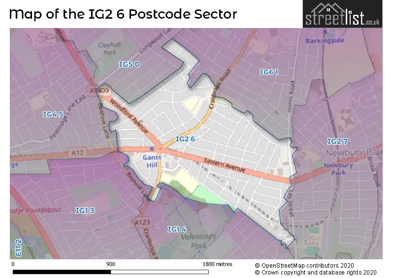
The largest settlement in the IG2 6 postal code is GANTS HILL followed by ILFORD , and BARKINGSIDE .
The IG2 6 Postcode shares a border with IG6 1 (BARKINGSIDE , ILFORD ), IG1 3 (CRANBROOK , ILFORD ), IG1 4 (ILFORD ), IG2 7 (NEWBURY PARK , BARKINGSIDE , ILFORD ), IG4 5 (ILFORD , GANTS HILL , CLAYHALL ) and IG5 0 (CLAYHALL , ILFORD ).
The sector is within the post town of ILFORD.
IG2 6 is a postcode sector within the IG2 postcode district which is within the IG Ilford postcode area.
The Royal Mail delivery office for the IG2 6 postal sector is the Ilford Delivery Office.
The area of the IG2 6 postcode sector is 0.61 square miles which is 1.58 square kilometres or 391.19 square acres.

Map of the IG2 6 Postcode Sector
Explore the IG2 6 postcode sector by using our free interactive map.
| I | G | 2 | - | 6 | X | X |
| I | G | 2 | Space | 6 | Letter | Letter |
Official List of Streets
ILFORD (59 Streets)
Unofficial Streets or Alternative Spellings
ILFORD
BEECHWOOD GARDENS BEEHIVE LANE COLLINWOOD GARDENS COLOMBO ROAD DONINGTON AVENUE EMERSON ROAD GOSFORD GARDENS HIGHWOOD GARDENS LEY STREET LOUDOUN AVENUE MONTREAL ROAD NORTHWOOD GARDENS PARKLANDS CLOSE PERRYMANS FARM ROAD SUNNYMEDE DRIVE THOROLD ROAD VERONIQUE GARDENS ALBEMARLE APPROACH BISHOPS WALK CITYGATE HOUSE GANTS HILL ROUNDABOUT HEDGEWOOD GARDENS LITTLE GEARIES OTLEY APPROACH SOUTH VIEW CRESCENT THORPEDALE GARDENS UPPARK DRIVEWeather Forecast for IG2 6
Press Button to Show Forecast for Ilford
| Time Period | Icon | Description | Temperature | Rain Probability | Wind |
|---|---|---|---|---|---|
| 03:00 to 06:00 | Cloudy | 6.0°C (feels like 3.0°C) | 3.00% | N 9 mph | |
| 06:00 to 09:00 | Partly cloudy (day) | 5.0°C (feels like 3.0°C) | 0.00% | N 9 mph | |
| 09:00 to 12:00 | Cloudy | 9.0°C (feels like 8.0°C) | 3.00% | NNE 7 mph | |
| 12:00 to 15:00 | Cloudy | 12.0°C (feels like 11.0°C) | 3.00% | WNW 4 mph | |
| 15:00 to 18:00 | Cloudy | 14.0°C (feels like 12.0°C) | 4.00% | W 9 mph | |
| 18:00 to 21:00 | Cloudy | 13.0°C (feels like 11.0°C) | 7.00% | W 11 mph | |
| 21:00 to 00:00 | Overcast | 11.0°C (feels like 8.0°C) | 25.00% | W 11 mph |
Press Button to Show Forecast for Ilford
| Time Period | Icon | Description | Temperature | Rain Probability | Wind |
|---|---|---|---|---|---|
| 00:00 to 03:00 | Cloudy | 9.0°C (feels like 7.0°C) | 52.00% | WSW 11 mph | |
| 03:00 to 06:00 | Overcast | 10.0°C (feels like 7.0°C) | 14.00% | W 11 mph | |
| 06:00 to 09:00 | Overcast | 10.0°C (feels like 7.0°C) | 11.00% | WNW 11 mph | |
| 09:00 to 12:00 | Cloudy | 11.0°C (feels like 8.0°C) | 8.00% | NW 13 mph | |
| 12:00 to 15:00 | Cloudy | 13.0°C (feels like 10.0°C) | 9.00% | NW 16 mph | |
| 15:00 to 18:00 | Cloudy | 13.0°C (feels like 10.0°C) | 8.00% | NNW 13 mph | |
| 18:00 to 21:00 | Partly cloudy (day) | 11.0°C (feels like 9.0°C) | 10.00% | N 11 mph | |
| 21:00 to 00:00 | Cloudy | 8.0°C (feels like 7.0°C) | 5.00% | NNE 7 mph |
Press Button to Show Forecast for Ilford
| Time Period | Icon | Description | Temperature | Rain Probability | Wind |
|---|---|---|---|---|---|
| 00:00 to 03:00 | Partly cloudy (night) | 7.0°C (feels like 4.0°C) | 2.00% | N 9 mph | |
| 03:00 to 06:00 | Partly cloudy (night) | 6.0°C (feels like 3.0°C) | 1.00% | NNW 9 mph | |
| 06:00 to 09:00 | Cloudy | 5.0°C (feels like 2.0°C) | 4.00% | NNW 9 mph | |
| 09:00 to 12:00 | Cloudy | 8.0°C (feels like 5.0°C) | 4.00% | N 11 mph | |
| 12:00 to 15:00 | Overcast | 10.0°C (feels like 8.0°C) | 7.00% | N 9 mph | |
| 15:00 to 18:00 | Cloudy | 11.0°C (feels like 9.0°C) | 5.00% | N 11 mph | |
| 18:00 to 21:00 | Cloudy | 10.0°C (feels like 8.0°C) | 4.00% | NNE 9 mph | |
| 21:00 to 00:00 | Partly cloudy (night) | 8.0°C (feels like 6.0°C) | 1.00% | NNE 7 mph |
Press Button to Show Forecast for Ilford
| Time Period | Icon | Description | Temperature | Rain Probability | Wind |
|---|---|---|---|---|---|
| 00:00 to 03:00 | Partly cloudy (night) | 7.0°C (feels like 5.0°C) | 1.00% | NNE 4 mph | |
| 03:00 to 06:00 | Partly cloudy (night) | 6.0°C (feels like 5.0°C) | 1.00% | NW 4 mph | |
| 06:00 to 09:00 | Cloudy | 6.0°C (feels like 4.0°C) | 4.00% | NNW 4 mph | |
| 09:00 to 12:00 | Cloudy | 9.0°C (feels like 7.0°C) | 5.00% | N 7 mph | |
| 12:00 to 15:00 | Overcast | 11.0°C (feels like 9.0°C) | 9.00% | N 9 mph | |
| 15:00 to 18:00 | Overcast | 12.0°C (feels like 10.0°C) | 13.00% | NNE 9 mph | |
| 18:00 to 21:00 | Cloudy | 12.0°C (feels like 10.0°C) | 8.00% | NNE 9 mph | |
| 21:00 to 00:00 | Cloudy | 9.0°C (feels like 8.0°C) | 10.00% | NE 7 mph |
Schools and Places of Education Within the IG2 6 Postcode Sector
Gearies Primary School
Community school
Waremead Road, Ilford, Essex, IG2 6TF
Head: Mr Robert Drew
Ofsted Rating: Outstanding
Inspection: 2014-10-01 (3487 days ago)
Website: Visit Gearies Primary School Website
Phone: 02085501803
Number of Pupils: 897
St Augustine's Catholic Primary School
Voluntary aided school
Cranbrook Road, Ilford, Essex, IG2 6RG
Head: Mr Pius Olorunfe-Ojo
Ofsted Rating: Good
Inspection: 2019-10-16 (1646 days ago)
Website: Visit St Augustine's Catholic Primary School Website
Phone: 02085541919
Number of Pupils: 450
Valentines High School
Community school
Cranbrook Road, Ilford, Essex, IG2 6HX
Head: Mr Richard Laws
Ofsted Rating: Outstanding
Inspection: 2021-10-06 (925 days ago)
Website: Visit Valentines High School Website
Phone: 02085543608
Number of Pupils: 1346
House Prices in the IG2 6 Postcode Sector
| Type of Property | 2018 Average | 2018 Sales | 2017 Average | 2017 Sales | 2016 Average | 2016 Sales | 2015 Average | 2015 Sales |
|---|---|---|---|---|---|---|---|---|
| Detached | £565,000 | 3 | £585,000 | 2 | £605,000 | 1 | £502,500 | 2 |
| Semi-Detached | £491,500 | 4 | £535,224 | 16 | £554,154 | 13 | £453,933 | 12 |
| Terraced | £501,427 | 69 | £519,103 | 60 | £478,615 | 66 | £408,396 | 93 |
| Flats | £276,022 | 41 | £273,927 | 56 | £299,067 | 101 | £244,738 | 54 |
Important Postcodes IG2 6 in the Postcode Sector
IG2 6AT is the postcode for London Borough of Redbridge, Perth Road, Perth Terrace
IG2 6AU is the postcode for Seven Kings Primary School, 2 Perth Road
IG2 6BN is the postcode for Cadet Centre, 67 Horns Road
IG2 6FJ is the postcode for Perth Terrace Hostel, 8 Perth Terrace, Newbury Park
IG2 6HX is the postcode for MATHS (BLOCK 6), Valentines High School, 348-360 Cranbrook Road, SPORTS HALL (BLOCK 4), Valentines High School, 348-360 Cranbrook Road, CDT BLOCK, Valentines High School, 348-360 Cranbrook Road, MAIN BUILDING (BLOCK 1), Valentines High School, 348-360 Cranbrook Road, Valentines High School, 348-360 Cranbrook Road, ICT (BLOCK 3), Valentines High School, 348-360 Cranbrook Road, MAIN BUILDING, Valentines High School, 348-360 Cranbrook Road, CDT & ART (BLOCK 2), Valentines High School, 348-360 Cranbrook Road, and SIXTH FORM BUILDING, Valentines High School, 348-360 Cranbrook Road
IG2 6LA is the postcode for London Borough of Redbridge, Gants Hill Library, 490 Cranbrook Road
IG2 6NN is the postcode for D W P, Wentworth House, 350 Eastern Avenue
IG2 6RG is the postcode for JUNIOR BLOCK, St. Augustine's Catholic Primary School, Cranbrook Road, and INFANT BLOCK, St. Augustine's Catholic Primary School, Cranbrook Road
IG2 6TD is the postcode for Redbridge Institute of Adult Education, Gaysham Avenue
IG2 6TF is the postcode for Gearies Primary School, Waremead Road
IG2 6TU is the postcode for Gearies Primary School, Gantshill Crescent, Gearies Infant School, Gantshill Crescent, and Gearies Junior School, Gantshill Crescent
IG2 6YG is the postcode for Redbridge Childrens Centre, Kenwood Gardens
| The IG2 6 Sector is within these Local Authorities |
|
|---|---|
| The IG2 6 Sector is within these Counties |
|
| The IG2 6 Sector is within these Water Company Areas |
|