The IP19 postcode district is a postal district located in the IP Ipswich postcode area with a population of 10,319 residents according to the 2021 England and Wales Census.
The area of the IP19 postcode district is 56.72 square miles which is 146.90 square kilometres or 36,300.50 acres.
Currently, the IP19 district has about 591 postcode units spread across 3 geographic postcode sectors.
Given that each sector allows for 400 unique postcode combinations, the district has a capacity of 1,200 postcodes. With 591 postcodes already in use, this leaves 609 units available.
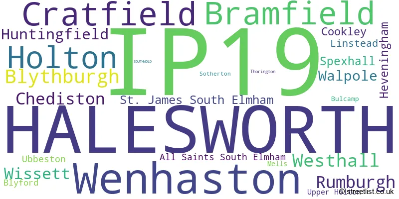
The largest settlement in the IP19 postal code is HALESWORTH followed by Wenhaston, and Holton.
The postcode area has a boundary with The North Sea.
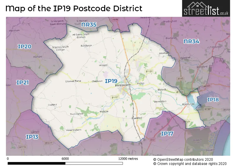
The IP19 Postcode shares a border with IP13 (Framlingham, Wickham Market, Grundisburgh), IP20 (HARLESTON, Alburgh, Metfield), IP21 (Stradbroke, Fressingfield, Scole), NR35 (BUNGAY, Ditchingham, Earsham), IP17 (SAXMUNDHAM, Kelsale, Yoxford), IP18 (SOUTHWOLD, Reydon, Walberswick) and NR34 (BECCLES, Worlingham, Wrentham).
The primary settlement in the IP19 postcode district is Halesworth, located in the county of Suffolk in England. Other significant settlements in the district include All Saints South Elmham, Chediston, Cookley, Cratfield, Heveningham, Huntingfield, Linstead, Rumburgh, Spexhall, St. James South Elmham, Ubbeston, Wissett, Blyford, Holton, Sotherton, Upper Holton, Westhall, Blythburgh, Bramfield, Bulcamp, Mells, Thorington, Walpole, and Wenhaston. The most significant postal town in the district is Halesworth.
For the district IP19, we have data on 4 postcode sectors. Here's a breakdown: The sector IP19 0, covers Cratfield and Rumburgh and Chediston in Suffolk. The sector IP19 1 is non-geographic. It's often designated for PO Boxes, large organisations, or special services. The sector IP19 8, covers Halesworth and Holton in Suffolk. The sector IP19 9, covers Wenhaston and Bramfield and Blythburgh and Walpole in Suffolk.

Map of the IP19 Postcode District
Explore the IP19 postcode district by using our free interactive map.
When it comes to local government, postal geography often disregards political borders. However, for a breakdown in the IP19 District: the district mostly encompasses the East Suffolk District area with a total of 591 postcodes.
Recent House Sales in IP19
| Date | Price | Address |
|---|---|---|
| 13/10/2023 | £261,000 | Rectory Street, Halesworth, IP19 8BS |
| 05/10/2023 | £935,000 | London Road, Halesworth, IP19 8LR |
| 05/10/2023 | £325,000 | Blyth View, Blythburgh, Halesworth, IP19 9LB |
| 28/09/2023 | £360,000 | The Street, Rumburgh, Halesworth, IP19 0JY |
| 22/09/2023 | £725,000 | Mill Road, Wissett, Halesworth, IP19 0RA |
| 21/09/2023 | £265,000 | Princes Green, Halesworth, IP19 8DP |
| 15/09/2023 | £465,000 | Holton Terrace, Halesworth, IP19 8HA |
| 15/09/2023 | £395,000 | Dunwich Road, Blythburgh, Halesworth, IP19 9LY |
| 05/09/2023 | £765,000 | Catalina Close, Halesworth, IP19 8DQ |
| 05/09/2023 | £505,000 | The Street, Holton, Halesworth, IP19 8PN |
Weather Forecast for IP19
Press Button to Show Forecast for Halesworth
| Time Period | Icon | Description | Temperature | Rain Probability | Wind |
|---|---|---|---|---|---|
| 21:00 to 00:00 | Cloudy | 5.0°C (feels like 2.0°C) | 6.00% | NW 9 mph |
Press Button to Show Forecast for Halesworth
| Time Period | Icon | Description | Temperature | Rain Probability | Wind |
|---|---|---|---|---|---|
| 00:00 to 03:00 | Cloudy | 5.0°C (feels like 1.0°C) | 6.00% | NW 9 mph | |
| 03:00 to 06:00 | Cloudy | 4.0°C (feels like 0.0°C) | 8.00% | NW 9 mph | |
| 06:00 to 09:00 | Cloudy | 5.0°C (feels like 1.0°C) | 33.00% | NW 11 mph | |
| 09:00 to 12:00 | Light rain | 7.0°C (feels like 3.0°C) | 48.00% | NNW 18 mph | |
| 12:00 to 15:00 | Overcast | 8.0°C (feels like 4.0°C) | 18.00% | NNW 16 mph | |
| 15:00 to 18:00 | Cloudy | 8.0°C (feels like 4.0°C) | 8.00% | NNW 16 mph | |
| 18:00 to 21:00 | Cloudy | 7.0°C (feels like 3.0°C) | 5.00% | NNW 11 mph | |
| 21:00 to 00:00 | Cloudy | 4.0°C (feels like 1.0°C) | 3.00% | WNW 7 mph |
Press Button to Show Forecast for Halesworth
| Time Period | Icon | Description | Temperature | Rain Probability | Wind |
|---|---|---|---|---|---|
| 00:00 to 03:00 | Overcast | 3.0°C (feels like 1.0°C) | 8.00% | W 7 mph | |
| 03:00 to 06:00 | Cloudy | 4.0°C (feels like 1.0°C) | 8.00% | WSW 9 mph | |
| 06:00 to 09:00 | Cloudy | 5.0°C (feels like 1.0°C) | 5.00% | W 9 mph | |
| 09:00 to 12:00 | Cloudy | 8.0°C (feels like 5.0°C) | 11.00% | W 11 mph | |
| 12:00 to 15:00 | Light rain shower (day) | 9.0°C (feels like 6.0°C) | 35.00% | WNW 11 mph | |
| 15:00 to 18:00 | Cloudy | 9.0°C (feels like 7.0°C) | 13.00% | NW 11 mph | |
| 18:00 to 21:00 | Light rain shower (day) | 7.0°C (feels like 5.0°C) | 29.00% | NW 7 mph | |
| 21:00 to 00:00 | Clear night | 4.0°C (feels like 2.0°C) | 4.00% | NNW 7 mph |
Press Button to Show Forecast for Halesworth
| Time Period | Icon | Description | Temperature | Rain Probability | Wind |
|---|---|---|---|---|---|
| 00:00 to 03:00 | Clear night | 3.0°C (feels like 0.0°C) | 2.00% | NW 7 mph | |
| 03:00 to 06:00 | Partly cloudy (night) | 2.0°C (feels like -1.0°C) | 2.00% | NW 4 mph | |
| 06:00 to 09:00 | Cloudy | 4.0°C (feels like 2.0°C) | 6.00% | NW 4 mph | |
| 09:00 to 12:00 | Cloudy | 8.0°C (feels like 7.0°C) | 7.00% | NE 7 mph | |
| 12:00 to 15:00 | Cloudy | 9.0°C (feels like 8.0°C) | 11.00% | E 7 mph | |
| 15:00 to 18:00 | Overcast | 10.0°C (feels like 8.0°C) | 12.00% | ESE 9 mph | |
| 18:00 to 21:00 | Cloudy | 8.0°C (feels like 6.0°C) | 9.00% | ESE 9 mph | |
| 21:00 to 00:00 | Cloudy | 7.0°C (feels like 4.0°C) | 12.00% | ESE 9 mph |
Press Button to Show Forecast for Halesworth
| Time Period | Icon | Description | Temperature | Rain Probability | Wind |
|---|---|---|---|---|---|
| 00:00 to 03:00 | Cloudy | 7.0°C (feels like 4.0°C) | 16.00% | ESE 9 mph | |
| 03:00 to 06:00 | Cloudy | 7.0°C (feels like 5.0°C) | 18.00% | ESE 9 mph | |
| 06:00 to 09:00 | Cloudy | 8.0°C (feels like 6.0°C) | 13.00% | SE 9 mph | |
| 09:00 to 12:00 | Overcast | 11.0°C (feels like 9.0°C) | 19.00% | SE 11 mph | |
| 12:00 to 15:00 | Cloudy | 12.0°C (feels like 9.0°C) | 15.00% | ESE 13 mph | |
| 15:00 to 18:00 | Cloudy | 12.0°C (feels like 10.0°C) | 14.00% | ESE 11 mph | |
| 18:00 to 21:00 | Cloudy | 11.0°C (feels like 9.0°C) | 11.00% | ESE 11 mph | |
| 21:00 to 00:00 | Cloudy | 10.0°C (feels like 8.0°C) | 11.00% | ESE 11 mph |
Where is the IP19 Postcode District?
The data indicates that the postcode district for IP19 is located in Halesworth, a town in Suffolk. Halesworth is nearby various other towns, including Bungay to the north (distance of 7.4 miles), Southwold to the east (distance of 8.4 miles), Beccles to the northeast (distance of 8.7 miles), Saxmundham to the south (distance of 8.7 miles), Harleston to the northwest (distance of 9.2 miles), and Leiston to the southeast (distance of 10.4 miles). Additionally, the distance to the center of London from this postcode district is approximately 89.6 miles.
The district covers the post towns of HALESWORTH, SOUTHWOLD.
The sector has postcodes within the nation of England.
The IP19 Postcode District is in the region of within the .
| Postcode Sector | Delivery Office |
|---|---|
| IP19 0 | Halesworth Delivery Office |
| IP19 8 | Halesworth Delivery Office |
| IP19 9 | Halesworth Delivery Office |
| I | P | 1 | 9 | - | X | X | X |
| I | P | 1 | 9 | Space | Numeric | Letter | Letter |
Tourist Attractions within the Postcode Area
We found 1 visitor attractions within the IP19 postcode area
| Halesworth and District Museum |
|---|
| Museums & Art Galleries |
| Museum and / or Art Gallery |
| View Halesworth and District Museum on Google Maps |
Current Monthly Rental Prices
| # Bedrooms | Min Price | Max Price | Avg Price |
|---|---|---|---|
| 1 | £595 | £675 | £623 |
| 2 | £875 | £875 | £875 |
| 3 | £1,975 | £1,975 | £1,975 |
| 4 | £1,295 | £1,350 | £1,323 |
| 7 | £3,995 | £3,995 | £3,995 |
Current House Prices
| # Bedrooms | Min Price | Max Price | Avg Price |
|---|---|---|---|
| £195,000 | £195,000 | £195,000 | |
| 1 | £67,500 | £169,000 | £105,929 |
| 2 | £80,000 | £600,000 | £267,838 |
| 3 | £175,000 | £1,000,000 | £392,340 |
| 4 | £320,000 | £785,000 | £503,448 |
| 5 | £615,000 | £950,000 | £775,000 |
| 6 | £745,000 | £1,350,000 | £1,047,500 |
| 7 | £850,000 | £850,000 | £850,000 |
| 8 | £1,150,000 | £1,150,000 | £1,150,000 |
Estate Agents who Operate in the IP19 District
| Logo | Name | Brand Name | Address | Contact Number | Total Properties |
|---|---|---|---|---|---|
 | Halesworth | Attik City Country Coast | The Cut Norwich Road, Halesworth, IP19 8BX | 01986 899532 | 33 |
 | Halesworth | Durrants | 12 Thoroughfare, Halesworth, IP19 8AH | 020 3870 2696 | 24 |
 | Framlingham | Clarke & Simpson | Well Close Square, Framlingham, IP13 9DU | 01728 443978 | 14 |
 | Halesworth | Musker McIntyre | 15A Thoroughfare, Halesworth, IP19 8AH | 020 3840 3654 | 12 |
 | Southwold | Winkworth | 45 High Street Southwold IP18 6DJ | 01502 441259 | 8 |
- All Saints' South Elmham
- Blackheath
- Blyford
- Blythburgh
- Bramfield
- Chediston
- Collipy's Green
- Cookley Street
- Cratfield
- Darsham
- Halesworth
- Heveningham
- Holton
- Huntingfield
- Ilketshall St Lawrence
- Laxfield
- Linstead Parva
- Mill Common
- Rumburgh
- St James South Elmham
- St Margaret South Elmham
- Stone Street
- Ubbeston
- Walpole
- Wenhaston
- Westhall
- Wissett
| Type of Property | 2018 Average | 2018 Sales | 2017 Average | 2017 Sales | 2016 Average | 2016 Sales | 2015 Average | 2015 Sales |
|---|---|---|---|---|---|---|---|---|
| Detached | £340,761 | 89 | £365,112 | 104 | £321,373 | 75 | £323,075 | 105 |
| Semi-Detached | £219,223 | 66 | £225,302 | 56 | £202,505 | 49 | £192,598 | 41 |
| Terraced | £232,041 | 40 | £190,453 | 43 | £191,641 | 43 | £181,001 | 36 |
| Flats | £127,938 | 12 | £140,000 | 16 | £143,875 | 14 | £114,111 | 9 |