The IP29 4 postcode sector is within the county of Suffolk.
Did you know? According to the 2021 Census, the IP29 4 postcode sector is home to a bustling 4,458 residents!
Given that each sector allows for 400 unique postcode combinations. Letters C, I, K, M, O and V are not allowed in the last two letters of a postcode. With 216 postcodes already in use, this leaves 184 units available.
The largest settlement in the IP29 4 postal code is Lawshall followed by Chedburgh, and Whepstead.
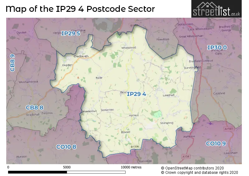
The IP29 4 Postcode shares a border with CO10 7 (Glemsford, Bulmer, SUDBURY), CO10 8 (Clare, Hundon, Cavendish), CO10 9 (Long Melford, Lavenham, Stanstead), CB8 8 (NEWMARKET, Wickhambrook, Moulton), IP30 0 (Cockfield, Rattlesden, Great Whelnetham) and IP29 5 (Barrow, Horringer, Chevington).
The sector is within the post town of BURY ST. EDMUNDS.
IP29 4 is a postcode sector within the IP29 postcode district which is within the IP Ipswich postcode area.
The Royal Mail delivery office for the IP29 4 postal sector is the Whepstead Scale Payment Delivery Office and Bury St. Edmunds Delivery Office.
The area of the IP29 4 postcode sector is 34.07 square miles which is 88.23 square kilometres or 21,802.99 square acres.
Waterways within the IP29 4 postcode sector include the Lark, River Glem, Chad Brook.

Map of the IP29 4 Postcode Sector
Explore the IP29 4 postcode sector by using our free interactive map.
| I | P | 2 | 9 | - | 4 | X | X |
| I | P | 2 | 9 | Space | 4 | Letter | Letter |
Official List of Streets
Lawshall (23 Streets)
Shimpling (13 Streets)
Stanningfield (11 Streets)
Chedburgh (17 Streets)
Brockley (8 Streets)
Hartest (11 Streets)
Whepstead (13 Streets)
Depden (4 Streets)
Rede (3 Streets)
Hawkedon (3 Streets)
Boxted (2 Streets)
Unofficial Streets or Alternative Spellings
Alpheton
AVELEY LANEGreat Whelnetham
STANNINGFIELD ROADHawstead
LAWSHALL ROAD WHEPSTEAD ROADHorringer
WHEPSTEAD ROADBrockley
HEDGEROWSStansfield
THURSTON LANEWeather Forecast for IP29 4
Press Button to Show Forecast for Rede
| Time Period | Icon | Description | Temperature | Rain Probability | Wind |
|---|---|---|---|---|---|
| 00:00 to 03:00 | Clear night | 0.0°C (feels like -2.0°C) | 0.00% | N 4 mph | |
| 03:00 to 06:00 | Clear night | -1.0°C (feels like -4.0°C) | 0.00% | NNW 4 mph | |
| 06:00 to 09:00 | Sunny day | 2.0°C (feels like -1.0°C) | 1.00% | NNW 4 mph | |
| 09:00 to 12:00 | Cloudy | 7.0°C (feels like 5.0°C) | 4.00% | NE 7 mph | |
| 12:00 to 15:00 | Cloudy | 9.0°C (feels like 8.0°C) | 6.00% | NE 4 mph | |
| 15:00 to 18:00 | Overcast | 9.0°C (feels like 8.0°C) | 10.00% | ENE 4 mph | |
| 18:00 to 21:00 | Cloudy | 8.0°C (feels like 6.0°C) | 8.00% | E 7 mph | |
| 21:00 to 00:00 | Cloudy | 4.0°C (feels like 2.0°C) | 9.00% | E 7 mph |
Press Button to Show Forecast for Rede
| Time Period | Icon | Description | Temperature | Rain Probability | Wind |
|---|---|---|---|---|---|
| 00:00 to 03:00 | Partly cloudy (night) | 3.0°C (feels like 0.0°C) | 7.00% | ENE 7 mph | |
| 03:00 to 06:00 | Cloudy | 2.0°C (feels like -1.0°C) | 13.00% | NE 7 mph | |
| 06:00 to 09:00 | Cloudy | 4.0°C (feels like 1.0°C) | 16.00% | ENE 9 mph | |
| 09:00 to 12:00 | Cloudy | 9.0°C (feels like 6.0°C) | 17.00% | ENE 9 mph | |
| 12:00 to 15:00 | Cloudy | 11.0°C (feels like 9.0°C) | 15.00% | E 9 mph | |
| 15:00 to 18:00 | Overcast | 11.0°C (feels like 9.0°C) | 19.00% | E 11 mph | |
| 18:00 to 21:00 | Cloudy | 10.0°C (feels like 7.0°C) | 17.00% | ENE 11 mph | |
| 21:00 to 00:00 | Overcast | 8.0°C (feels like 5.0°C) | 20.00% | NE 11 mph |
Press Button to Show Forecast for Rede
| Time Period | Icon | Description | Temperature | Rain Probability | Wind |
|---|---|---|---|---|---|
| 00:00 to 03:00 | Light rain | 8.0°C (feels like 5.0°C) | 48.00% | ENE 11 mph | |
| 03:00 to 06:00 | Heavy rain | 9.0°C (feels like 6.0°C) | 74.00% | ESE 11 mph | |
| 06:00 to 09:00 | Light rain | 9.0°C (feels like 7.0°C) | 52.00% | SE 11 mph | |
| 09:00 to 12:00 | Light rain shower (day) | 11.0°C (feels like 8.0°C) | 44.00% | SSE 13 mph | |
| 12:00 to 15:00 | Heavy rain shower (day) | 11.0°C (feels like 9.0°C) | 61.00% | S 13 mph | |
| 15:00 to 18:00 | Light rain shower (day) | 12.0°C (feels like 10.0°C) | 44.00% | SW 13 mph | |
| 18:00 to 21:00 | Light rain shower (day) | 11.0°C (feels like 9.0°C) | 34.00% | SW 11 mph | |
| 21:00 to 00:00 | Partly cloudy (night) | 8.0°C (feels like 6.0°C) | 6.00% | WSW 9 mph |
Schools and Places of Education Within the IP29 4 Postcode Sector
All Saints' Church of England Voluntary Controlled Primary School, Lawshall
Voluntary controlled school
The Street, Bury St Edmunds, Suffolk, IP29 4QA
Head: Ms Clare Pamela Lamb
Ofsted Rating: Outstanding
Inspection: 2010-12-03 (4893 days ago)
Website: Visit All Saints' Church of England Voluntary Controlled Primary School, Lawshall Website
Phone: 01284828223
Number of Pupils: 171
Hartest Church of England Primary School
Academy sponsor led
The Row, Bury St Edmunds, Suffolk, IP29 4DL
Head: Mrs Amanda Woolmer
Ofsted Rating: Special Measures
Inspection: 2021-09-22 (947 days ago)
Website: Visit Hartest Church of England Primary School Website
Phone: 01284830343
Number of Pupils: 49
House Prices in the IP29 4 Postcode Sector
| Type of Property | 2018 Average | 2018 Sales | 2017 Average | 2017 Sales | 2016 Average | 2016 Sales | 2015 Average | 2015 Sales |
|---|---|---|---|---|---|---|---|---|
| Detached | £459,329 | 41 | £489,457 | 35 | £393,402 | 26 | £519,771 | 35 |
| Semi-Detached | £364,909 | 11 | £295,416 | 25 | £315,081 | 18 | £290,000 | 14 |
| Terraced | £240,099 | 5 | £244,143 | 14 | £210,050 | 10 | £265,595 | 10 |
| Flats | £0 | 0 | £0 | 0 | £0 | 0 | £0 | 0 |
| The IP29 4 Sector is within these Local Authorities |
|
|---|---|
| The IP29 4 Sector is within these Counties |
|
| The IP29 4 Sector is within these Water Company Areas |
|